MAAP #156: Intense Mining Activity in Yapacana National Park (Venezuelan Amazon)


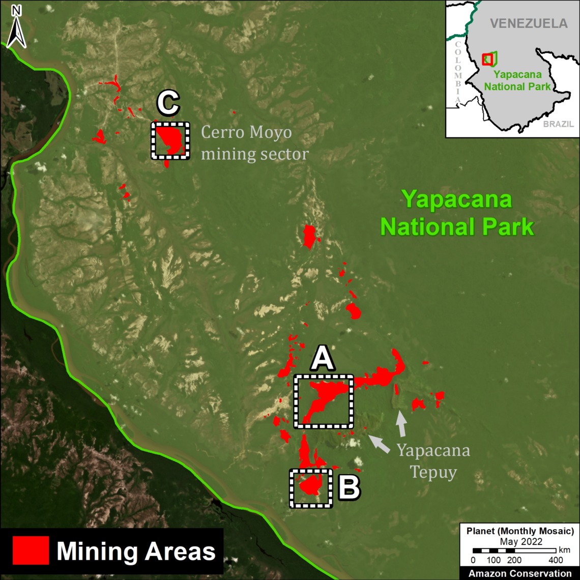
Base Map: Mining areas in Yapacana National Park. Data: SOS Orinoco, ACA/MAAP, Planet.
We present the second report in our series focused on the Venezuelan Amazon.
The first (MAAP #155) documented the loss of over 140,000 hectares (345,000 acres) of primary forest over the past four years. We also zoomed in on the major hotspots, showing that mining is one of the primary deforestation drivers, including in protected areas.
Here we focus on a key protected area, Yapacana National Park.
The park, created in 1978, is a key biogeographical site, with diverse ecosystems (including white sand savannahs), high endemism and biodiversity, and unique Guiana Shield outcrops. Illegal mining started in the park in the 1980s and started to surge in the 2000s (see SOS Orinoco 2020 for details on the complex socio-political issues).
We show Yapacana National Park is currently experiencing intense illegal mining activity.
Specifically, we carried out a detailed estimate of current mining camps and machinery, based on recent and very high-resolution Skysat satellite imagery from Planet (0.5 meters).
We found over 8,000 mining data points (over 4,100 camps and 3,800 pieces of machinery), indicating that Yapacana National Park may currently be the most impacted site in the Amazon (replacing the case La Pampa in the buffer zone of Tambopata National Reserve, in the southern Peruvian Amazon), based on density of mining-related activity.
The goal of this report is to precisely inform the international community about the magnitude of the crisis in Yapacana National Park in hopes of an eventual solution.
Intense Mining in Yapacana National Park
The Base Map (see above) shows the major mining sectors in Yapacana National Park and our Skysat coverage over the recent time period of December 2021 to March 2022 (vertical dark green polygons). In this area, we recorded an astounding 8,214 mining data points (4,167 camps and 3,884 pieces of machinery). This finding is consistent with previous estimates that there are over 2,000 illegal miners operating in the park (and even indicates that this is an underestimate).
The Letters A-C correspond to the zoom images below.
Zoom A: Cerro Yapacana (north)
Zoom A centers on a major mining area in the Cerro Yapacana sector that experienced the deforestation of 360 hectares since the early 2000s, including a spike starting in 2016. It shows a very high-resolution Skysat image from early December 2021, with and without the mining data (left and right panel, respectively). Note how the second image brings out previously “invisible” elements within the overall mining area: 945 mining data points (413 camps and 532 equipment). Further below, Zooms A1 and A2 further illustrate this point.
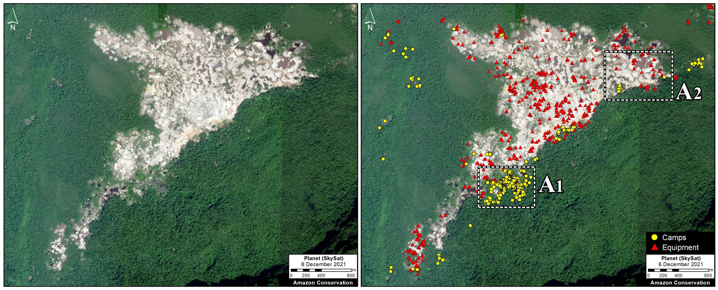
Zoom A. Mining activity in the Cerro Yapacana northern sector without (left panel) and with (right panel) the mining data. Data: ACA/MAAP, Planet (Skysat).
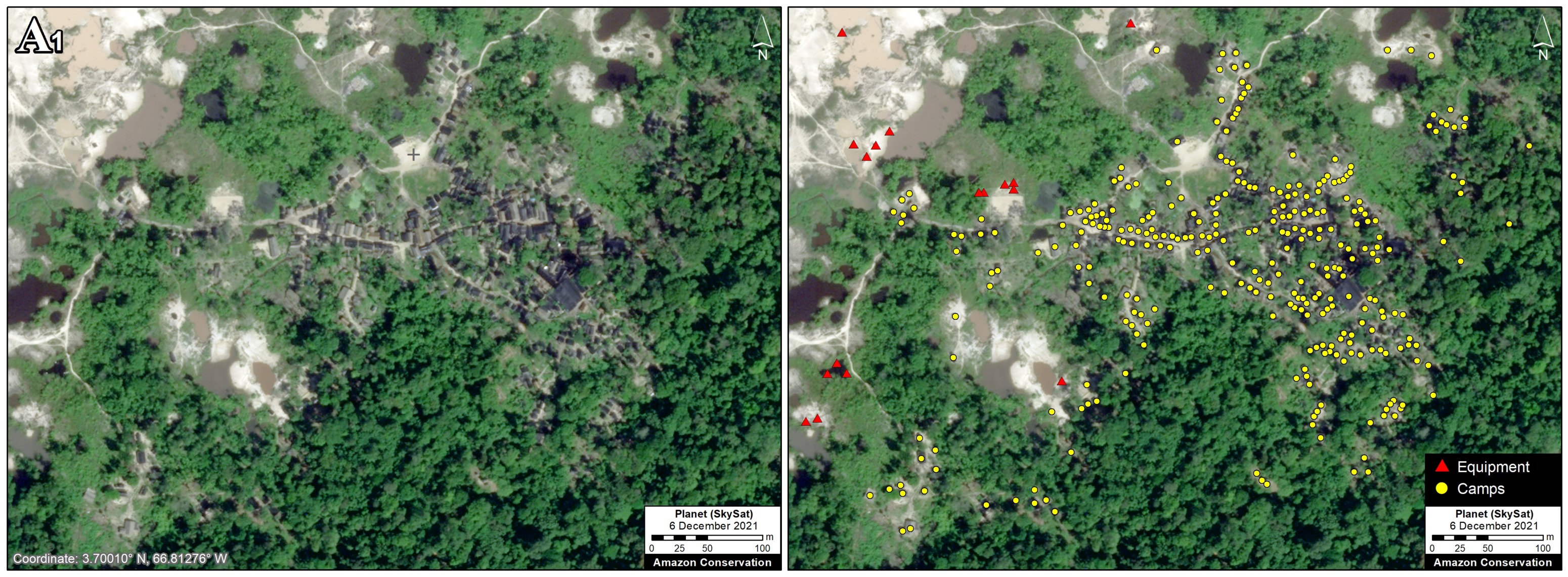
Zoom A1. Mining activity in the Cerro Yapacana sector without (left panel) and with (right panel) the mining data. Data: ACA/MAAP, Planet (Skysat).
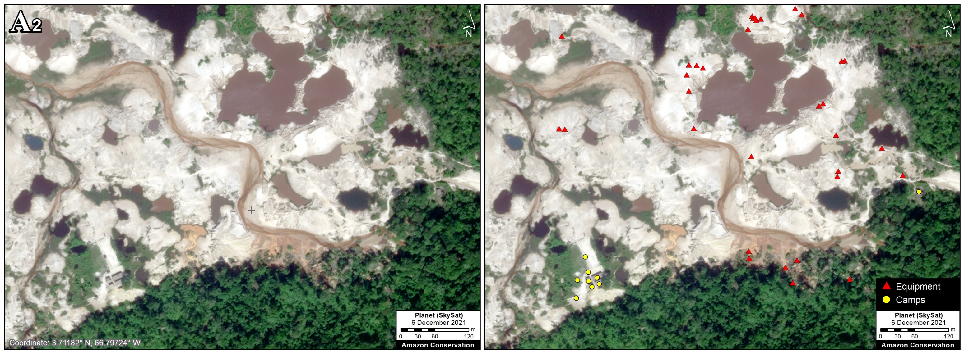
Zoom A2. Mining activity in the Cerro Yapacana sector without (left panel) and with (right panel) the mining data. Data: ACA/MAAP, Planet (Skysat).
Zoom B: Cerro Yapacana (south)
Zoom B centers on a major mining area in the Cerro Yapacana sector that experienced the deforestation of 175 hectares since the early 2000s, including a spike starting in 2014. It shows a very high-resolution Skysat image from early December 2021, with and without the mining data (left and right panel, respectively). Note how the second image brings out previously “invisible” elements within the overall mining area: 1,175 mining data points (667 camps and 508 equipment). Again, note how the second image brings out previously “invisible” elements within the overall mining area. Zooms B1 and B2 further illustrate this point.
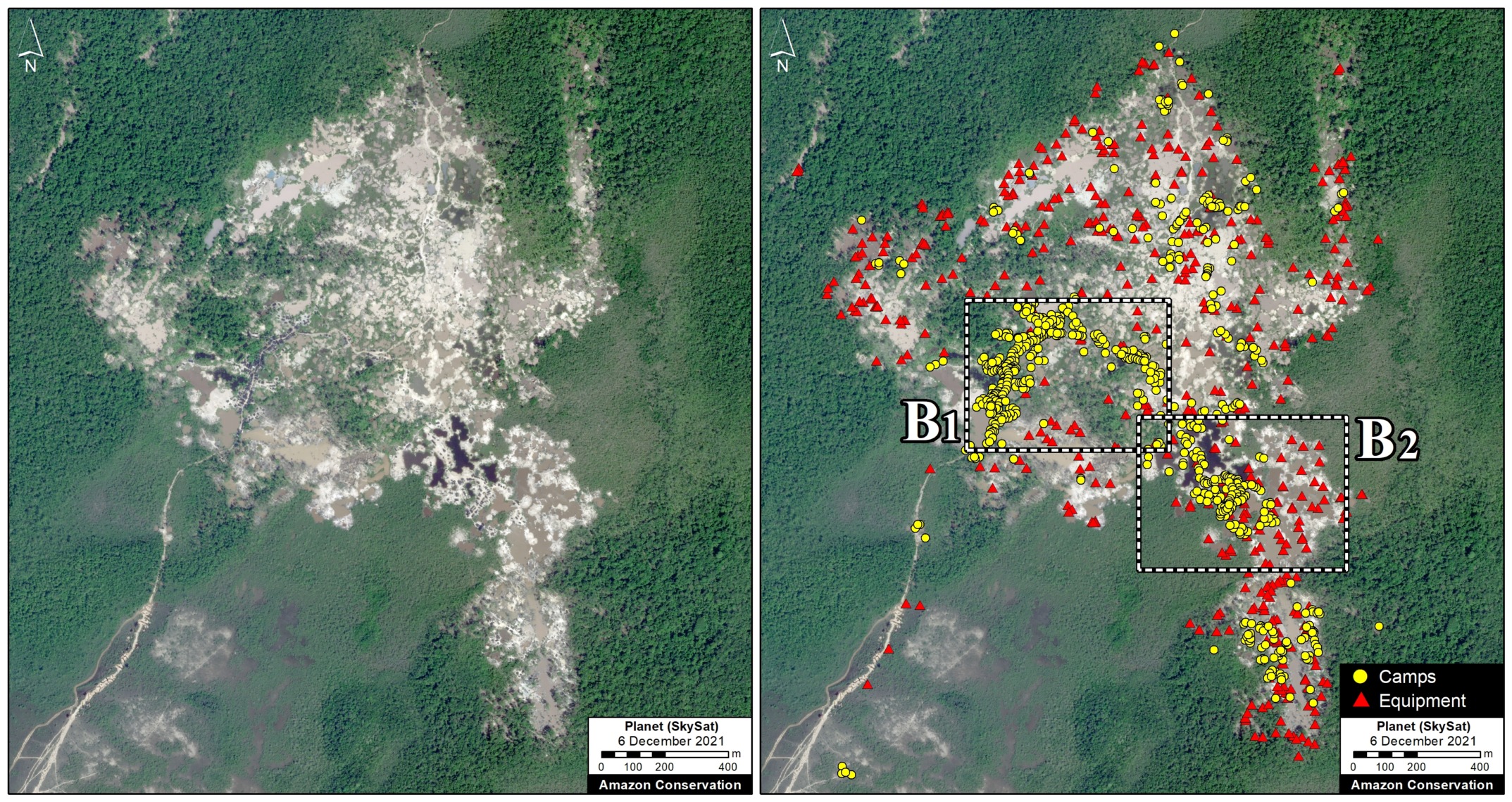
Zoom B. Mining activity in the Cerro Yapacana southern sector without (left panel) and with (right panel) the mining data. Data: ACA/MAAP, Planet (Skysat).
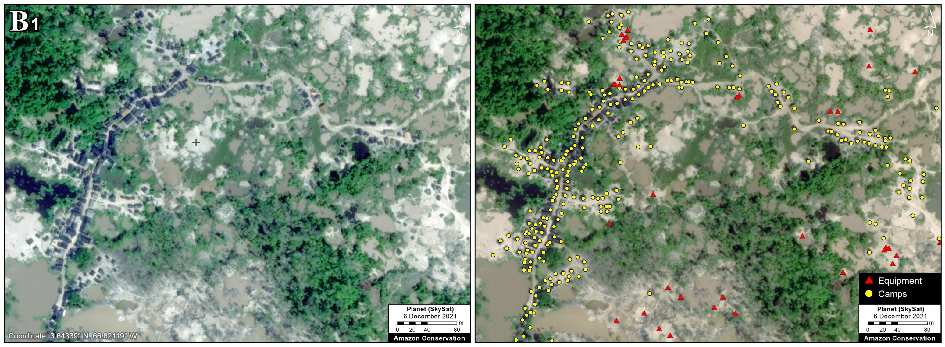
Zoom B1. Mining activity in the Cerro Yapacana southern sector without (left panel) and with (right panel) the mining data. Data: ACA/MAAP, Planet (Skysat).
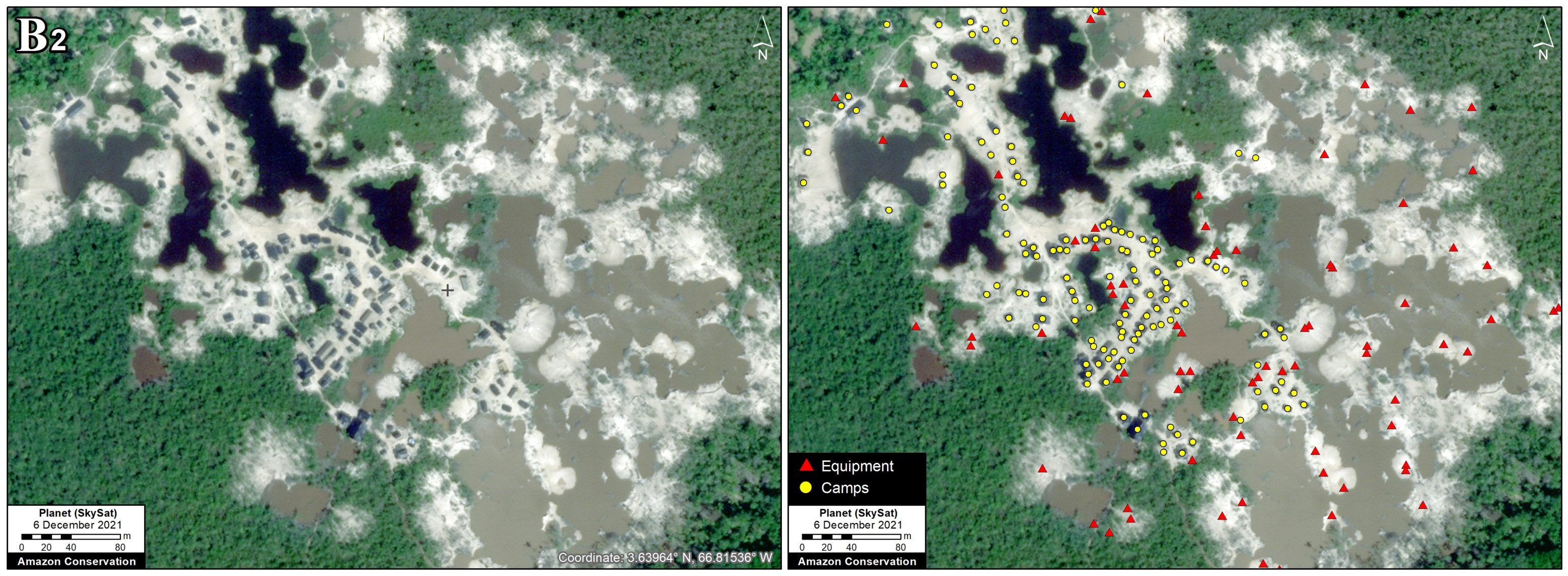
Zoom B2. Mining activity in the Cerro Yapacana southern sector without (left panel) and with (right panel) the mining data. Data: ACA/MAAP, Planet (Skysat).
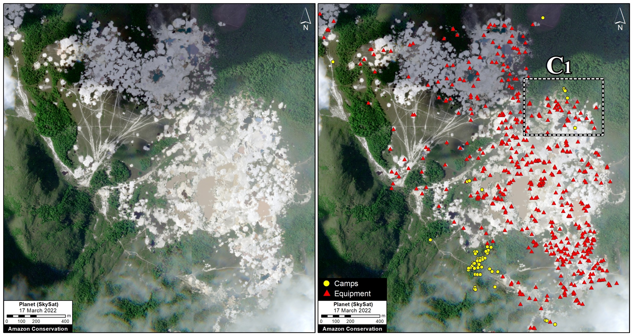
Zoom C: Cerro Moyo
Lastly, Zoom C centers on a major mining area in the Cerro Moyo sector that experienced the deforestation of 240 hectares since the early 2000s, including a spike starting in 2011. It shows a very high-resolution Skysat image from March 2022, with and without the mining data (left and right panel, respectively). Again, note how the second image brings out previously “invisible” elements within the overall mining area: 579 data points (55 camps and 524 equipment). Zoom C1 further illustrates this point.
Zoom C. Mining activity in the Cerro Moyo sector without (left panel) and with (right panel) the mining data. Data: ACA/MAAP, Planet (Skysat).
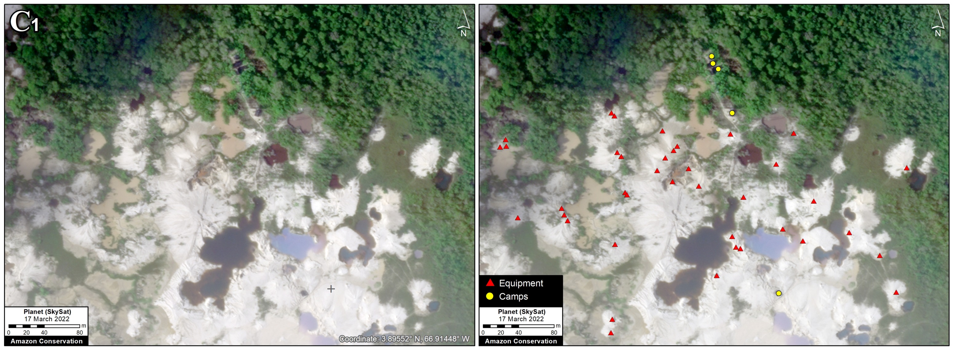
Zoom C1. Mining activity in the Cerro Moyo sector without (left panel) and with (right panel) the mining data. Data: ACA/MAAP, Planet (Skysat).
Methodology
We tasked very high-resolution Skysat satellite imagery (0.5 meters), using the host company Planet’s tasking dashboard, of known mining locations in Yapacana National Park. We then closely and manually analyzed these images, documenting both mining camps and equipment. We researched aerial examples of mining areas in other countries to improve our identification abilities.
As a guide to locate key mining zones in these areas, we used mining area data produced by the organization SOS Orinoco, which used manual visual interpretation methods to identify these areas.
References
BirdLife International. Yapacana National Park (Parque Nacional Yapacana IBA). http://datazone.birdlife.org/site/factsheet/14941
Castillo R. y V. Salas. 2007. Estado de Conservación del Parque Nacional Yapacana. Reporte Especial. En: BioParques: Programa Observadores de Parques
SOS Orinoco. 2019. La Minería Aurífera en el Parque Nacional Yapacana Amazonas Venezolano: Un caso de extrema urgencia ambiental y geopolítica, nacional e internacional.
Acknowledgements
We thank the organization SOSOrinoco for important information and comments related to this report.
Citation
Finer M, Mamani N (2022) Intense Mining Activity in Yapacana National Park (Venezuelan Amazon). MAAP: 156.
Download PDF of this article