MAAP #204: New Road Construction in Waorani Indigenous Territory (Ecuadorian Amazon)

We analyze a new road project that enters the western sector of the Waorani Indigenous Territory, located in the heart of the Ecuadorian Amazon (see Base Map, below).

The project, called “Construction of the Arajuno-Nushiño-Ishpingo-Toñampade Road”, has been designed in response to the mobility needs of eight Waorani communities in the area, including Toñampade, the most populated community in the territory.

This road would cross 42 kilometers of primary forest from the Nushiño River to the community of Toñampade. Therefore, there is great potential to open new deforestation fronts along the route.

This road project was managed, approved, and promoted through the Waorani Nationality of Ecuador (NAWE) and its construction is led by the Provincial Government of Pastaza.

The Environmental Impact Study and  Management Plan for this road was prepared in 2016 and approved in 2018 and mentions the importance of protecting the biodiversity of the area and the cultural importance of the Amazon rainforests in the Waorani Territory.

In March 2023, the Waorani Organization of Pastaza (OWAP) presented a complaint to the Ministry of the Environment, in which it requested to suspend the construction of the road until the protection of the ecosystems is ensured.

In July, an assembly convened by the NAWE was held to discuss the road project, in which a consensus was sought with the OWAP to restart construction. The agreement was obtained that both Waorani entities, and the communities of Pastaza, will provide monitoring and control so that the technical specifications of the Environmental Impact Study and  Management Plan are met.

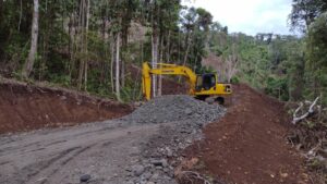
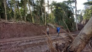
The objective of this report is to analyze the current state of the road, focused on deforestation caused by the construction (see Image 1), and the actions carried out by Waorani organizations to monitor the project.

Base Map of the Road Project

The Base Map shows the location of the project “Construction of the Arajuno-Nushiño-Ishpingo-Toñampade Road”, located in the heart of the Ecuadorian Amazon.

Base Map. Nushiño-Toñampade satellite monitoring area. Data: Planet-NICFI, EcoCiencia.

Road Construction

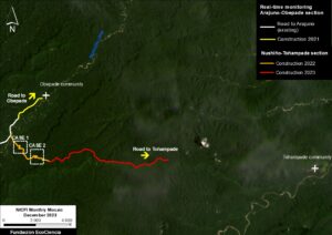
To document the current state of the road, we analyzed satellite imagery from September 2021 to January 2024. We found a total of 15.8 kilometers of construction (see Image 2).

In September 2021, the construction of the road section towards the community of Obepade was carried out, extending the previously built road from Arajuno (white line), with a new additio of 2.1 kilometers (yellow line).

From July 2022 to July 2023, construction was carried out from the Nunshiño River, reaching a total of 13.7 km towards Toñampade (orange and red lines). There is no evidence of new construction since July 2023, likely due to the above-noted complaint from OWAP.

Thus, the project still needs to construct 28.3 km through primary forest to reach Toñampade.

Image 2. Progress of the Nushiño-Toñampade road. Data: EcoCiencia; Planet-NICFI.

Territorial Monitoring of Road Construction

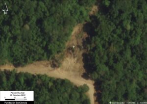
Image 3.

In 2022, the Waorani Nationality of Ecuador – NAWE, through its territorial technical team Kenguiwe, carried out the first territorial monitoring and surveillance tours to identify the environmental and social impacts of road construction.

Two cases were discovered where the construction of the road has generated deforestation processes along the route. See the location of these two cases in Image 2.

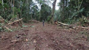
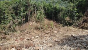
In the first case, an area of 0.54 hectares was deforested as a consequence of the construction of the road (Image 3). Potentially this deforestation process occurred to find alternative routes to the road.


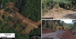
In the second case, 5.27 hectares was deforested, additionally leading to a mudslide.

Monitoring by  the Waorani Nationality of Ecuador

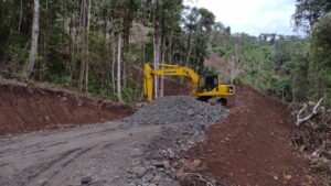
Here we present a series of photographs from the territorial monitoring by the Waorani Nationality of Ecuador, investigating the impacts of the new road construction. All photo credits to the NAWE monitoring program.


Acknowledgments

We thank NAWE for facilitating and authorizing the use of the information and images generated by the monitoring work carried out by its technical team called “Kenguiwe”, with financial support from the EcoCiencia Foundation and the French Development Agency (AFD)  through the TerrIndigena Project.

This report is part of a series focused on the Ecuadorian Amazon through a strategic collaboration between the organizations Fundación EcoCiencia and Amazon Conservation, with the support of the Norwegian Development Cooperation Agency (Norad).

Ecociencia Logo


MAAP #206: Direct Link Emerges between Mennonites and Potential Large-scale Deforestation in Suriname

In the recent MAAP #203, we reported that the government of Suriname is preparing to clear large tracts of Amazon rainforest for agriculture.

Specifically, we estimated that a shocking 451,000 hectares (1.1 million acres) of primary forest were threatened in the proposed agricultural plots.

Intertwined with this issue are additional reports indicating that groups of Mennonites are in the process of relocating to Suriname from Bolivia. This raised alarms given the extensive large-scale agriculture deforestation caused by Mennonites in the Amazon regions of both Peru and Bolivia.

Here we report the first evidence directly linking the Mennonites with potential large-scale deforestation in Suriname.

As background, the agricultural real estate company Terra Invest is responsible for all aspects of the project to bring select Mennonites families to Suriname from Bolivia1. As detailed in the Bolivian news outlet Nomadas, the Suriname government would grant the agriculture land to Terra Invest, who would then transfer the land to societies formed by Mennonites in Suriname. 

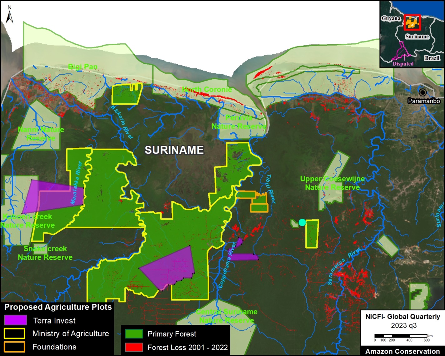
Newly leaked government documents, from Suriname’s Ministry of Land and Forest Management dated to February 2023, provide the first available spatial data on the location of proposed lands to Terra Invest.

These lands are broken down into three separate areas, totaling 78,775 hectares.

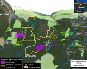
The Base Map shows these Terra Invest request areas (purple) in relation to the previously published information on proposed agricultural plots to the Ministry of Agriculture and Foundations backed by private land developers.

Potential Primary Forest Loss

We performed an additional analysis looking at how much primary forest is contained and threatened in these proposed agriculture plots to Terra Invest. This analysis was based on data from the University of Maryland and Global Forest Watch.

In Figure 2, we show that the proposed Terra Invest plots threaten 76,932 hectares of primary forest. Note that 8,991 hectares of primary forest overlaps with Kaboeri Creek Nature Preserve.

We also that of the above total, 22,675 hectares of primary forest are in addition to what was previously calculated for the Ministry of Agriculture lands. Thus, we now estimate that 473,675 of primary forest are threatened across all three types of proposed agriculture plots (Terra Invest, Ministry of Agriculture, and Foundations).

Notes

  1. Bolivian mennonites bring the «hell» of deforestation to Suriname

Citation

Finer M, Goedschalk J, Arinez Z (2024). Direct Link Emerges between Mennonites and Potential Large-scale Deforestation in Suriname. MAAP: 206.

MAAP #203: Massive Planned Deforestation in Amazon of Suriname

In a recent article, the environmental science news platform Mongabay reported that, according to their review of official documents, the government of Suriname is preparing to clear large tracts of Amazon rainforest for agriculture.

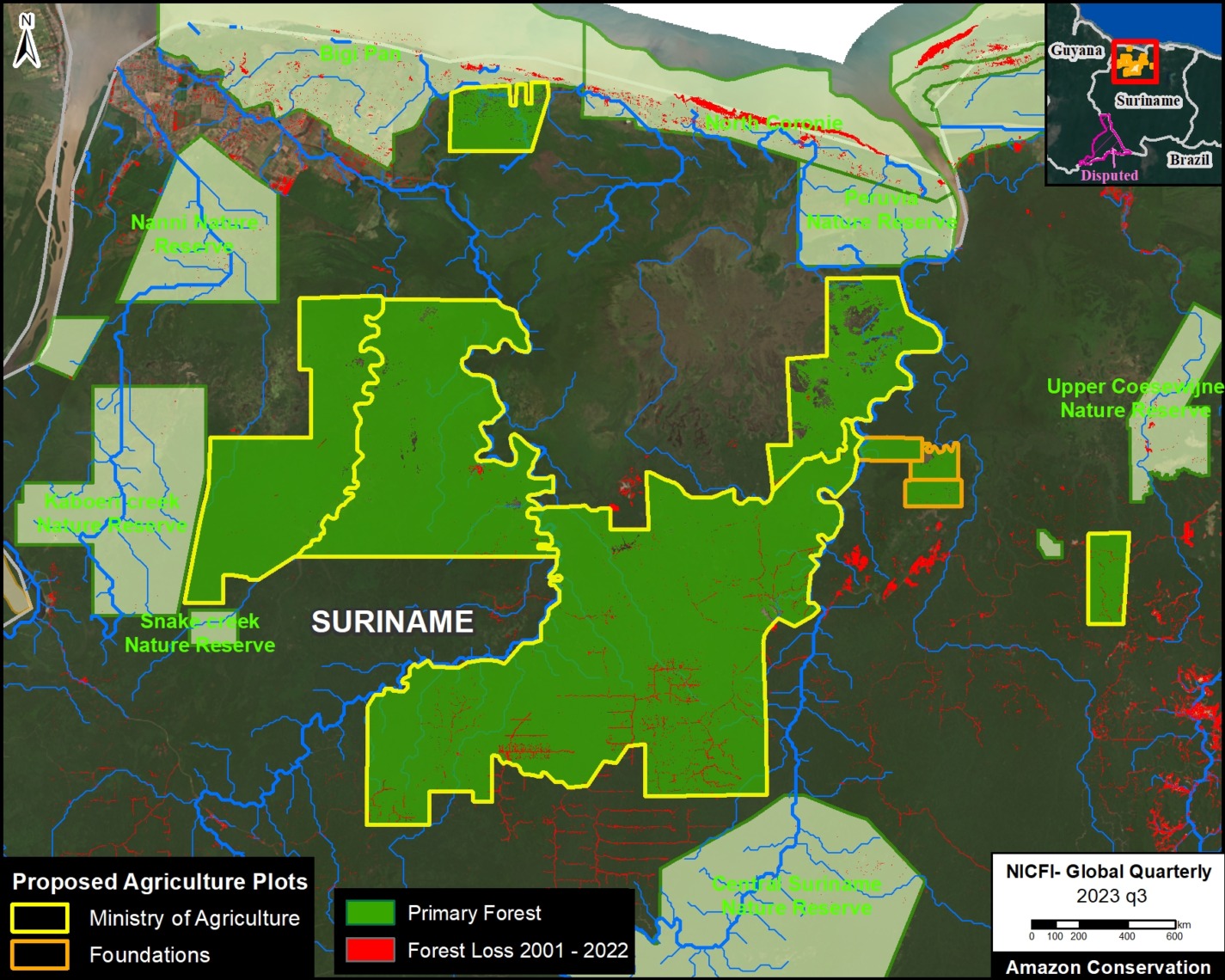
Mongabay reported that a massive amount of land (365,704 hectares, or 903,674 acres) was being targeted for new agriculture plots being established for the Ministry of Agriculture (354,836 hectares) and private land developers (10,868 hectares).

This is additionally noteworthy because large-scale agriculture is not historically or currently a deforestation driver in Suriname, so these new plots would likely trigger unprecedented forest loss in one of the world’s few remaining countries dominated by primary rainforest.

Intertwined with this issue are additional reports indicating that groups of Mennonites are planning to relocate to Suriname. This news has also raised alarms given the extensive deforestation caused by Mennonites in the Amazon regions of both Peru (7,032 hectares) and Bolivia (210,980 hectares).

In their article, Mongabay gathered information from the government documents to create a map of the proposed agriculture plots. We then digitized this map, calibrated it with coordinates in the documents, and then conducted our own analysis.

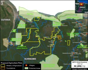
The Base Map shows our digitized map of the agricultural plots, with the inclusion of protected areas and Indigenous & Tribal Peoples villages, all overlayed on top of a recent satellite image.

We estimate 467,000 hectares in the proposed new agricultural plots (456,238 ha for the Ministry of Agriculture and 10394 ha for Foundations backed by private land developers). Note this is substantially higher than the estimate reported by Mongabay. Additional analysis of the documents indicates that the actual total could rise to 560,000 hectares.

Potential Primary Forest Loss

We performed an additional analysis looking at how much primary forest is contained and threatened in these proposed agriculture plots. This analysis was based on data from the University of Maryland and Global Forest Watch.

In Figure 2, we estimate 451,000 hectares of threatened primary forest in the proposed agriculture plots (441,362 ha for the Ministry of Agriculture and 9,958 ha for Foundations backed by private land developers).

This would result in a shocking amount of primary forest loss for a country that has experienced an average annual deforestation of 6,560 hectares over the past 21 years (137,746 hectares in total since the year 2002).

Citation

Finer M, Goedschalk J, Arinez Z (2024) Massive Planned Deforestation in Amazon of Suriname. MAAP: 203.

MAAP #202: Protecting Strategic, Free-flowing River Corridors in the Ecuadorian Amazon

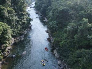
Aerial photo of a section of the proposed river conservation corridor, highlighting some of the key components of the proposal: free-flowing river, intact riparian forest, and sustainable, low-impact tourism. Photo credit: Wil Henkel

Here, we present a model river conservation strategy proposed by the Ecuadorian Rivers Institute, designed to protect strategic free-flowing river corridors with intact surrounding forests in the critical transition zone between the Andes mountains and the Amazon lowlands.

The vision is to conserve freshwater resources and their surrounding riparian forests, encourage sustainable economic alternatives, and preserve free-flowing ecological connectivity at the basin scale.

There are few remaining high-quality and ecologically intact Andean-Amazon watershed corridors in Ecuador, making their protection and management an urgent national priority, ideally as part of a larger global tropical river conservation strategy

The proposal targets strategic corridors that have three major characteristics:

  1. Free-flowing rivers with no dams, diversions, or channel modifications, and no mining or dredging.
    h
  2. High-quality rivers that are a reference for water quality and have exceptional natural and cultural values.
    j
  3. Forested riparian buffer zones to preserve the quality and integrity of the river corridor, enhance the ecological connectivity between protected areas, and preserve habitat throughout critical transition zones.

These core components provide the key elements that are needed to preserve, restore, and enhance the integrity of the freshwater biodiversity, aquatic ecosystems, and scenic landscapes of strategic, free-flowing river corridors in the tropical Andes.

Priorities for River Protection in Ecuador
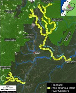
Base Map. Proposed free-flowing and intact riparian forest corridors (highlighted in yellow) in the northern Ecuadorian Amazon. Data: ERI.

The Base Map illustrates two proposed pilot projects in the northern Ecuadorian Amazon. Both represent key habitats for native fisheries and migratory birds and are important destinations for sustainable ecotourism activities. Following these two examples, national, regional (Amazon-scale), and global river protection programs could be created to include additional watershed corridors.

Jondachi-Hollín-Misahuallí-Napo River Corridor

The Jondachi and Hollín Rivers are major free-flowing tributaries of the Misahuallí River sub-basin in the Napo River watershed. These rivers drain from the Antisana and the Sumaco Napo Galeras National Parks, and provide strategic connectivity in a critical transition zone between montane cloudforests and lowland rainforest.

The proposed corridor would protect 200 km of free-flowing rivers and 19,050 hectares of riparian forest (with the application of 500m-wide buffers) within the Sumaco Biosphere Reserve. A significant portion of the corridor is within a forest reserve to provide enhanced connectivity and protection. The proposed corridor is an established destination for a variety of low-impact ecotourism activities that provide significant benefits to the local economy.

Piatúa River Corridor

The Piatúa River is another world-class paddle sports ecotourism destination that is renowned for its natural bathing areas with crystal clear water and sculpted granite boulders. The Piatúa River is a tributary of the Anzu River sub-basin of the Napo River watershed, which drains out of rugged paramo tundra and montane cloud forests deep within the Llanganates National Park, and provides critical ecosystem connectivity through a wide elevation range with high levels of endemic species.

The proposed corridor would protect 46 km of free-flowing rivers and tributaries and 947 hectares of riparian forest (with the application of a 100m-wide riparian buffer)

River Conservation Strategy

Guidelines for Protection

Legally binding frameworks are needed which restrict the development of intensive land-use activities and hydraulic infrastructure, and guarantee high-level, permanent protection of natural river corridors and natural instream flow regimes, with riparian buffer zones to preserve aquatic habitat and water quality. Ecuador has an existing framework which can be used to designate protected river corridors with the same status as national parks. However, until now it has only been applied to protect small catchment basin areas for sources of drinking water in headwater tributaries.

Management recommendations

Comprehensive management plans must be developed with meaningful public participation, and provisions for monitoring, control and enforcement of restricted activities. Independent monitoring and evaluation is necessary to ensure adequate compliance and implementation is achieved. Academic institutions should be encouraged to participate and develop research programs which reinforce the management objectives.

Social component

The successful implementation of the proposed river protection strategy depends on the active participation and endorsement by the local population and people who use the resource, along with adequate governance, and sufficient funding for management and incentives.

Protecting the river corridor ensures sustainable economic benefits for the inhabitants of the region through low-impact ecotourism activities (such as kayaking, rafting, mountain biking, bird watching, and hiking) which are compatible with the management of the resource.

However, additional financial incentives (such as land grants) are needed to reach other sectors of the population in order to take pressure off of the increasing encroachment into the forested riparian corridors for timber harvesting and subsistence-level agricultural expansion.

Ongoing support and guidance is also needed for local communities and landowners to identify employment opportunities and encourage other sustainable production activities in order to optimize the use of degraded areas outside of the protected riparian buffers.

In the case of plastic recycling, the population of Ecuador has responded favorably to adapting cultural and behavioral norms in response to small incentives created by a tax on plastic beverage containers, to address a significant waste management issue. This is a positive sign for what to expect if incentives are provided for protecting natural river corridors.

Financial mechanisms

Securing long-term financial commitments is a fundamental component to ensure the viability of any natural resource protection program. Most developing countries are burdened by foreign debt and are struggling to meet their fiscal obligations and priorities, which often lessens priorities for environmental management. However, experience has shown that the international community responds favorably to reinforce commitments made by host countries to preserve natural and cultural heritage of global significance, and debt forgiveness and debt reduction transactions for host country governments, from wealthy countries would be expected to provide some funding for the proposed strategy to protect strategic free-flowing river corridors in Ecuador.

The Government of Ecuador is facing a critical economic situation. However, water conservation funds have been successfully implemented to cover the cost of managing the protection of drinking water sources for metropolitan areas by including a small environmental management fee on monthly water bills. Some of these water conservation funds have generated substantial levels of endowment to the point where they could have the potential to provide funding for the protection of strategic river corridors, if that was authorized by the water fund consortium.

While the outcome of COP28 may have put a temporarily damper on the value of the nascent carbon credit market, once the programs are restructured to provide for improved accountability and implementation, the expectations for carbon credits to provide a source of long-term funding for the protection and management of strategic free-flowing river corridors as a climate mitigation strategy are quite encouraging, as are expectations for eventual funding allocations for river protection to be derived from the COP21 Paris Climate Accord, and the Global Environmental Facility (GEF).

Meanwhile, voluntary contributions from hydroelectric projects and extractive projects to offset their impacts by designating a percentage of annual income from the generation of electricity for the protection of free-flowing river corridors.

Likewise, voluntary contributions from international finance institutions based on a percentage of annual revenue disbursed through their investment portfolio could provide meaningful support for the protection of free-flowing river corridors, once these agreements are established.

Annex

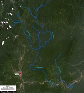
Herre is a recent satellite image of the Jondachi-Hollín-Misahuallí-Napo River Corridor. Note the intact river and forest core to the east of the major road network, and north of the Napo River.
 

Citation

Terry M, Finer M, Ariñez A (2023) Protecting Free-flowing & Intact River Corridors in the Ecuadorian Amazon. MAAP: 202.