MAAP: Amazon Fire Tracker #2 – Brazil, June 8 2020
June 9, 2020
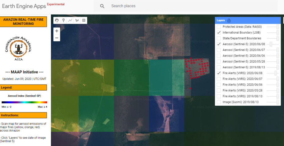
As presented in MAAP #118, Amazon Conservation launched a real-time fire monitoring app that specializes in detection of elevated aerosol emissions from burning Amazon fires. As detailed below, the app detected the second major 2020 fire on June 8, 2020 in Mato Grosso, Brazil.
Step 1. Detection of elevated emissions in the southeastern Brazilian Amazon (Mato Grosso).
Step 2. Zoom in on the emissions, adjust the transparency to see the underlying fire alerts that indicate the fire location.
Step 3. Zoom in again to see precisely the fire location and obtain coordinates.
Step 4. Check the satellite imagery archive in Planet Explorer. Here is a Landsat image (30 meter resolution) showing the fire burned around 3,000 hectares (7,400 acres) of an area deforested in July 2018. Note that MAAP #113 made the important discovery that most of the 2019 Brazilian Amazon fires were burning recently deforested areas (and not uncontrolled forest fires).![]()
Coordinates
References
Acknowledgements
This work was supported by the following major funders: USAID/NASA (SERVIR), Global Forest Watch Small Grants Fund (WRI), Norwegian Agency for Development Cooperation (NORAD), International Conservation Fund of Canada (ICFC), Metabolic Studio, and Erol Foundation.
Citation
Finer M, Villa L (2020) Amazon 2020 Fire Tracker #2 – Brazil, June 8. MAAP.


