MAAP #150: New Oil Platforms Deeper into Yasuni National Park (Ecuador), towards Uncontacted Indigenous Zone

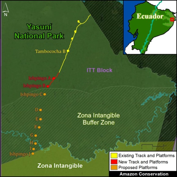
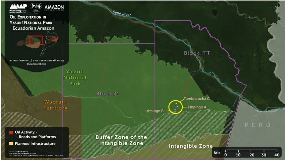
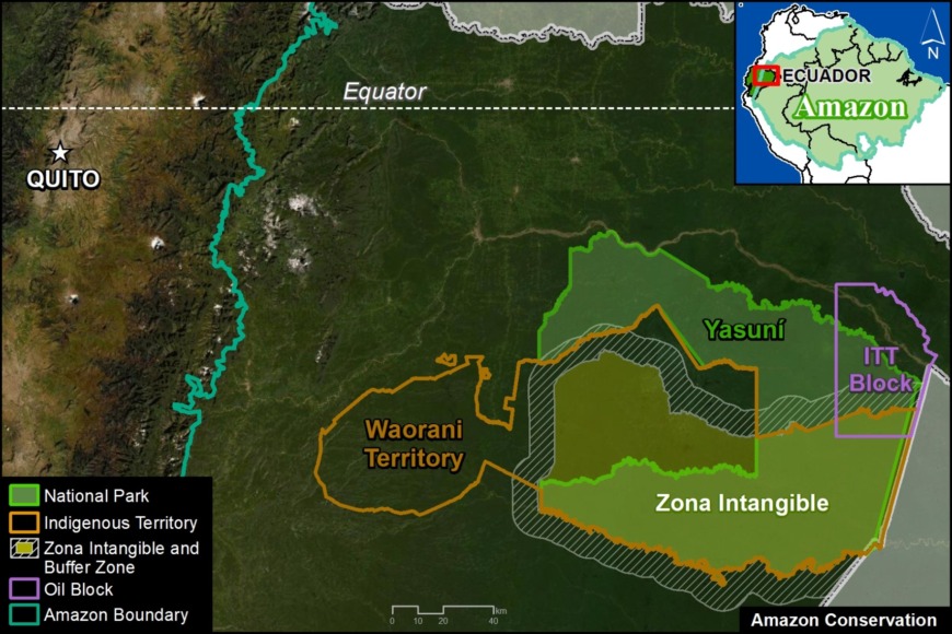
Base Map. Location of Yasuni National Park, ITT Block, and Zona Intangible in the Ecuadorian Amazon.

Yasuni National Park, located in the heart of the Ecuadorian Amazon, is one of the most biodiverse places in the world thanks to its unique location at the intersection of the Amazon, Andes Mountains, and the equator (see Base Map).

In addition, it is part of the ancestral territory of the Waorani indigenous peoples. The entire southern portion of Yasuni National Park has been declared an Untouchable Zone (Zona Intangible) to protect the territory of the relatives of the Waorani who live in voluntary isolation (Tagaeri-Taromenane).

In a series of previous reports, we have shown the construction of oil drilling platforms (and associated access road) in the ITT Block. This controversial block, run by the state oil company Petroecuador, is located in the remote and largely intact northeast sector of Yasuni National Park.

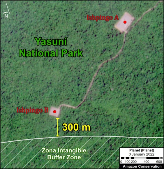
In this report, based on the latest satellite images, we show the most recent construction within the ITT Block: an oil drilling platform known as Ishpingo B. This platform is located just 300 meters from the buffer zone of the Zona Intangible.

We also issue a warning about the future construction of additional oil drilling platforms that would enter the buffer zone and reach the limit of the Zona Intangible itself.

Image 1. Data: Planet, MAAP/ACA.

Ishpingo Platforms A & B

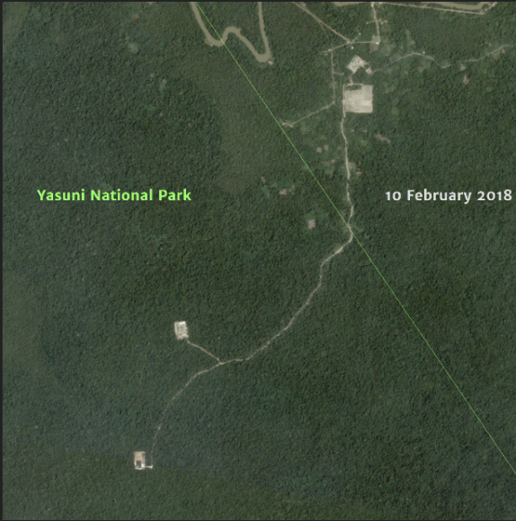
The following images show the construction of the two new oil drilling platforms (Ishpingo A and B) in the heart of the Yasuni National Park (ITT Block).

Image 1 (on the right) shows that the newest and southernmost platform (Ishpingo B) is located just 300 meters from the buffer zone of the Zona Intangible.

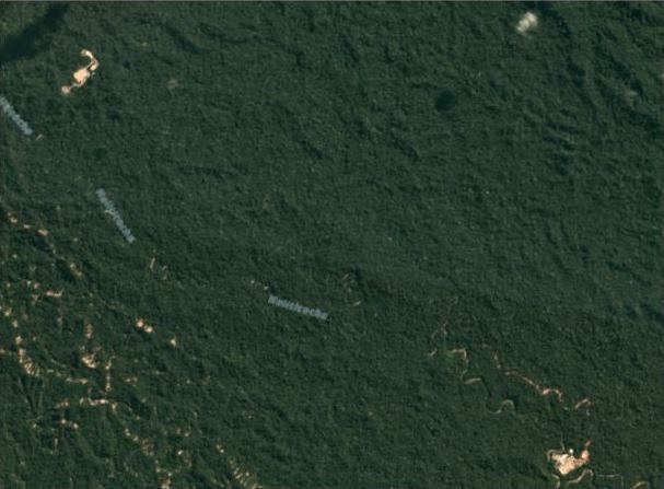
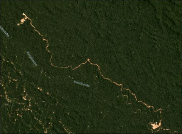
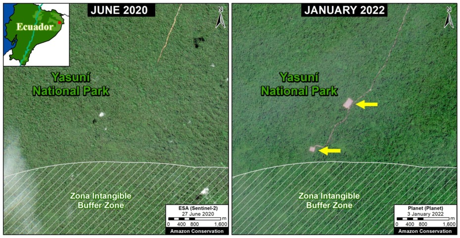
Image 2 (below) shows the construction of the two new platforms and associated access road between June 2020 (left panel) and January 2022 (right panel).

It is worth mentioning that the construction of these platforms has a corresponding environmental license in accordance with the “Environmental Impact Study and Environmental Management Plan of the Ishpingo North Development and Production Project.”

Image 2. Data ESA, Planet, MAAP/ACA.
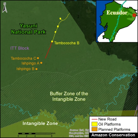
Image 3. Data: MAAP/ACA, Energy and Environmental Consulting.

Towards the Zona Intangible

Image 3 shows (in red) the location of the two new platforms (Ishpingo A and B) in relation to Yasuni National Park and the Zona Intangible.

Once again, note that the newest and southernmost platform (Ishpingo B) is located just 300 meters from the buffer zone of the Zona Intangible.

Alert: It is critical to emphasize that a previous version of the Environmental Impact Study includes plans for the construction of eight additional platforms (Ishpingo C-J), all located within the buffer zone towards the limit of the Zona Intangible Zone.

In fact, in early 2022, the head of Petroecuador has begun to publicly state the importance of moving forward with these extremely controversial plans.

Acknowledgments

We thank M. Bayón and P. Bermeo for useful information about the Environmental Impact Studies.

This report is part of a series focused on the Ecuadorian Amazon through a strategic collaboration between the organizations Fundación EcoCiencia and Amazon Conservation, with the support of the Norwegian Agency for Development Cooperation (Norad) and the International Conservation Fund of Canada (ICFC).

Citation

Finer M, Mamani N, Josse C, Villacis S (2022) New Oil Platforms Deeper into Yasuni National Park (Ecuador), towards Uncontacted Indigenous Zone. MAAP: 150.
MAAP #117: New Oil Road Deeper into Yasuni National Park (Ecuador), Towards Uncontacted Indigenous Reserve

Yasuní National Park, located in the heart of the Ecuadorian Amazon, is one of the most biodiverse spots in the world and overlaps ancestral Waorani territory. In the recent MAAP #114, we showed the construction of four new oil drilling platforms (and access road) in the controversial ITT oil block, located in the heart of Yasuní.

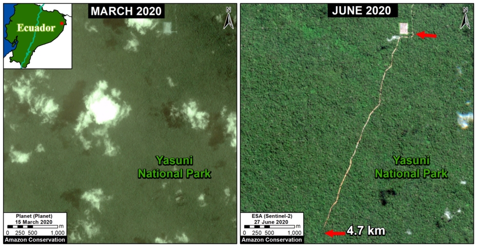
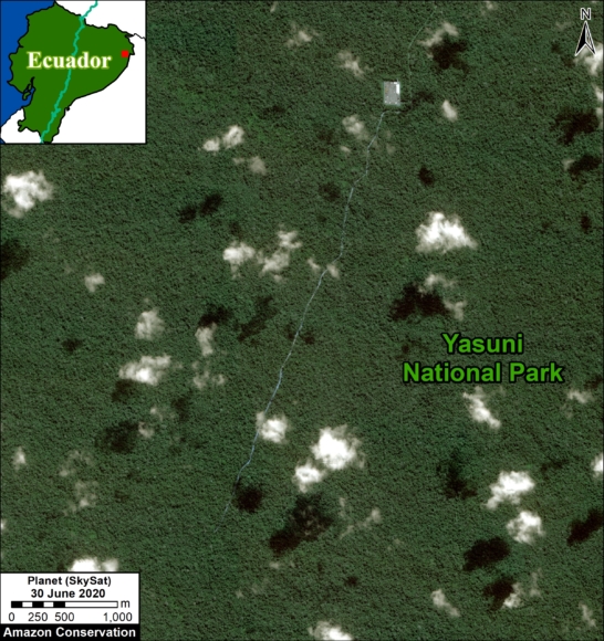
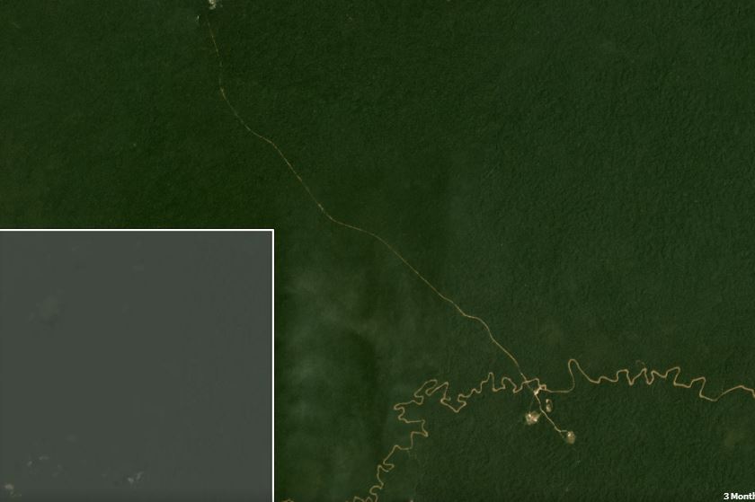
Here, we show that, beginning in mid-March 2020, we detected the construction of a new access road heading further south from the last platform (Image 1). As of early May, this road construction was 4.7 km through primary forest.

Updated: June 30 (4.7 km); June 14 (3.7 km); May 17 (2.2 km).

Image 1. Construction of a new 4.7 km oil access road deeper into Yasuni National Park between March (left panel) and June (right panel) 2020. Click to enlarge.

Implications of the New Oil Road

This finding is concerning because it brings oil development closer to the “Zona Intangible,” a reserve created to protect the territory of indigenous people in voluntary isolation (Tagaeri, Taromenane), isolated relatives of the Waorani.

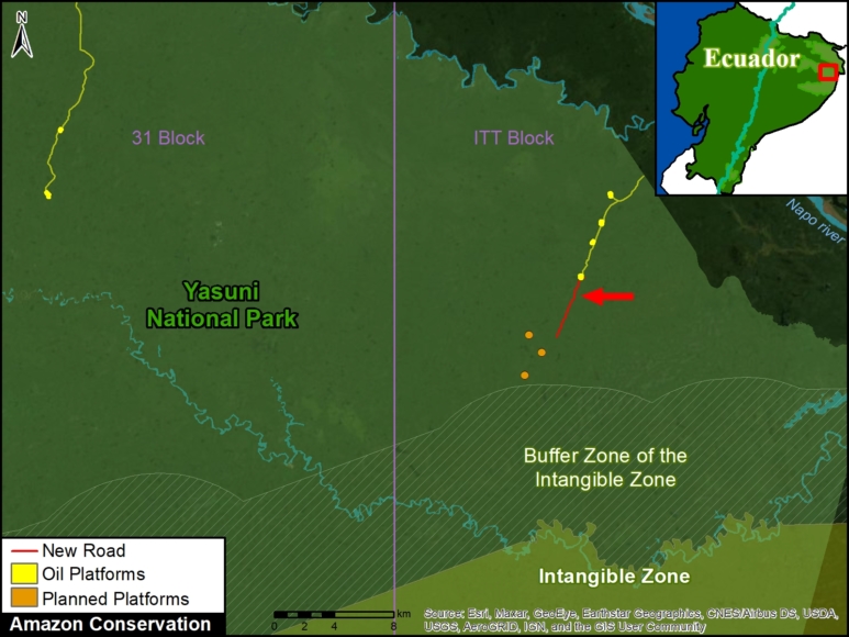
In Image 2, the location of the new road (indicated in red) is shown approaching several planned oil drilling platforms just outside the buffer zone of the Zona Intangible. Image 3 shows a zoom of this area.

It is also concerning because construction is occurring during the coronavirus pandemic.

Image 2. The new oil acces road (in red) approaching the Zona Intangible.

Very High Resolution Image

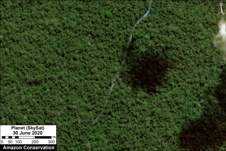
We have also obtained a very high resolution satellite image (Skysat, 0.8 meters) of the new oil access road. Below are two examples of this image; the first shows the complete route of the new highway and the second is a zoom of the most recent expansion to the south. Click to enlarge.

Finer M, Mamani N (2020) New Oil Road Deeper into Yasuni National Park. MAAP: 116.

MAAP #114: Oil Drilling Pushes Deeper into Yasuni National Park

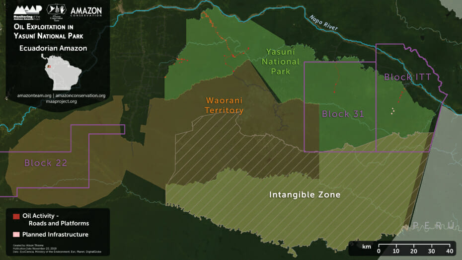
Base Map. Oil Exploitation in Yasuni National Park. Click to enlarge.

Yasuni National Park, located in the heart of the Ecuadorian Amazon, is one of the most biodiverse places in the world and forms part of the ancestral territory of the Waorani (see Base Map).

Under the ground of this vast area, however, are large oil fields.

In July 2019, the Waorani won an important legal victory to prevent oil activity in the western part of their territory (Block 22).

However, here we show the construction of new oil drilling platforms in the controversial ITT Block, in the northeast part of Yasuni National Park.

We calculated the deforestation of 57.3 hectares (141.6 acres) for drilling platforms and access roads within ITT and the adjacent Block 31.

In addition, incorporating edge effects caused by the deforestation, we estimate the impacted area is actually 655 hectares (1,619 acres), exceeding the limit of 300 hectares (741 acres) established in the public referendum of 2018.*


ITT Block

The ITT Block covers one of the most remote and intact parts of Yasuni National Park. In 2007, the Ecuadorian government launched a unique initiative to keep ITT’s oil underground in exchange for economic compensation from the international community (Yasuni-ITT Initiative).

In 2013, however, the Initiative failed and was abandoned. Indeed, the government is now actively advancing it’s ITT oil extraction plans.

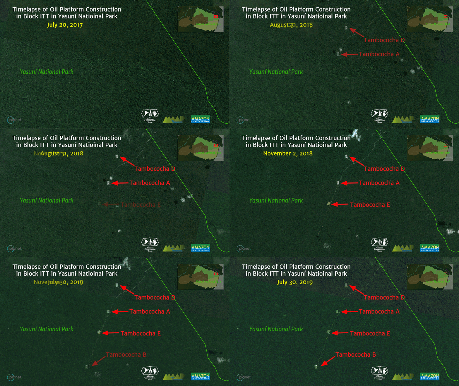
Next, we present a video of satellite images showing the recent oil-related activity inside the ITT Block, within Yasuni National Park. It involves the construction of 4 drilling platforms (Tambococha A,B,D, E) and an access road, between 2017 and 2019. The associated deforestation is 28.5 hectares (70 acres).

Zona Intangible (Untouchable Zone)

There are plans for at least 3 more drilling platforms deeper into Yasuni National Park (see yellow circle in map below). These platforms would bring oil activity close to the buffer zone of an area known as the Zona Intangible, or Untouchable Zone.

The government established the Zona Intangible in 2007 as an area where extractive activities, including oil, are prohibited to protect the territory of the Waorani relatives in voluntary isolation (Tagaeri and Taromenane).

Planned oil platforms (yellow circle) near the buffer zone of the Zona Intangible. Click to enlarge.

*Notes

Edge effects are the impacts that extend into the surrounding forest from the edge of deforestation. These impacts include changes in forest structure and microclimate, higher tree mortality, and increased susceptibility to fire. Based on Broadbent et al (2008), we incorporated an edge effect of 100 meters, which represents the median distance of edge effects recorded in 62 scientific studies. This is a conservative estimate given that an edge effect of 300-2000 meters could be also be justified according to the data.

In MAAP #82, we documented the oil-related deforestation of more than 400 hectares (990 acres) throughout all of Yasuni National Park.

Referenes

Bass M, Finer M, Jenkins C et al (2010) Global Conservation Significance of Ecuador’s Yasuní National Park. PLOS ONE. Link: https://journals.plos.org/plosone/article?id=10.1371/journal.pone.0008767

Finer M et al (2009) Ecuador’s Yasuní Biosphere Reserve: a brief modern history and conservation challenges. ERL. Link: https://iopscience.iop.org/article/10.1088/1748-9326/4/3/034005/fulltext/

Broadbent EB, Asner GP et al (2008) Forest fragmentation and edge effects from deforestation
and selective logging in the Brazilian Amazon. Bio Cons 141:1745–1757.

Acknowledgements

We thank A. Puyol (EcoCiencia), M. Bayon (Colectivo de Geografía Crítica del Ecuador), E. Martínez,  and G. Palacios for helpful comments to earlier versions of this report.

This work was supported by the following major funders: Norwegian Agency for Development Cooperation (NORAD), MacArthur Foundation, International Conservation Fund of Canada (ICFC), Metabolic Studio, and Global Forest Watch Small Grants Fund (WRI).

Citation

Finer M, Thieme A, Hettler B (2019) Oil Drilling Pushes Deeper into Yasuni National Park (Ecuador). MAAP: 114.

MAAP #82: Oil-related Deforestation in Yasuni National Park, Ecuadorian Amazon

MAAP #82: Oil-related Deforestation in Yasuni National Park, Ecuadorian Amazon
https://www.maaproject.org/yasuni_eng/ 

Yasuni National Park, located in the heart of the Ecuadorian Amazon, is arguably the most biodiverse area in the world. It is also the ancestral territory of the Waorani, and their relatives in voluntary isolation.

However, underneath the park are large oil fields, setting up the constant conflict looming over Yasuni. In fact, in a recent referendum, Ecuadorian voters approved limiting the oil extraction area within Yasuni National Park to 300 hectares (740 acres).

Here, we analyze high-resolution satellite imagery to estimate both direct and indirect oil-related deforestation within Yasuní National Park.

For direct impact, we document the deforestation of 169 hectares (418 acres) within the park for oil-related infrastructure.
For indirect impact, we document the deforestation of 248 hectares (613 acres) due to colonization along an oil access road.
The total direct and indirect deforestation due to oil extraction is 417 hectares (1,030 acres).

Thus, one could argue that the oil-related deforestation has already exceeded the 300 hectares (740 acres) approved by the voters.

We illustrate these results in a Story Map.

MAAP #82: Oil-related Deforestation in Yasuni National Park, Ecuadorian Amazon
https://www.maaproject.org/yasuni_eng/