MAAP 214: Agriculture in the Amazon: New data reveals key patterns of crops & cattle pasture

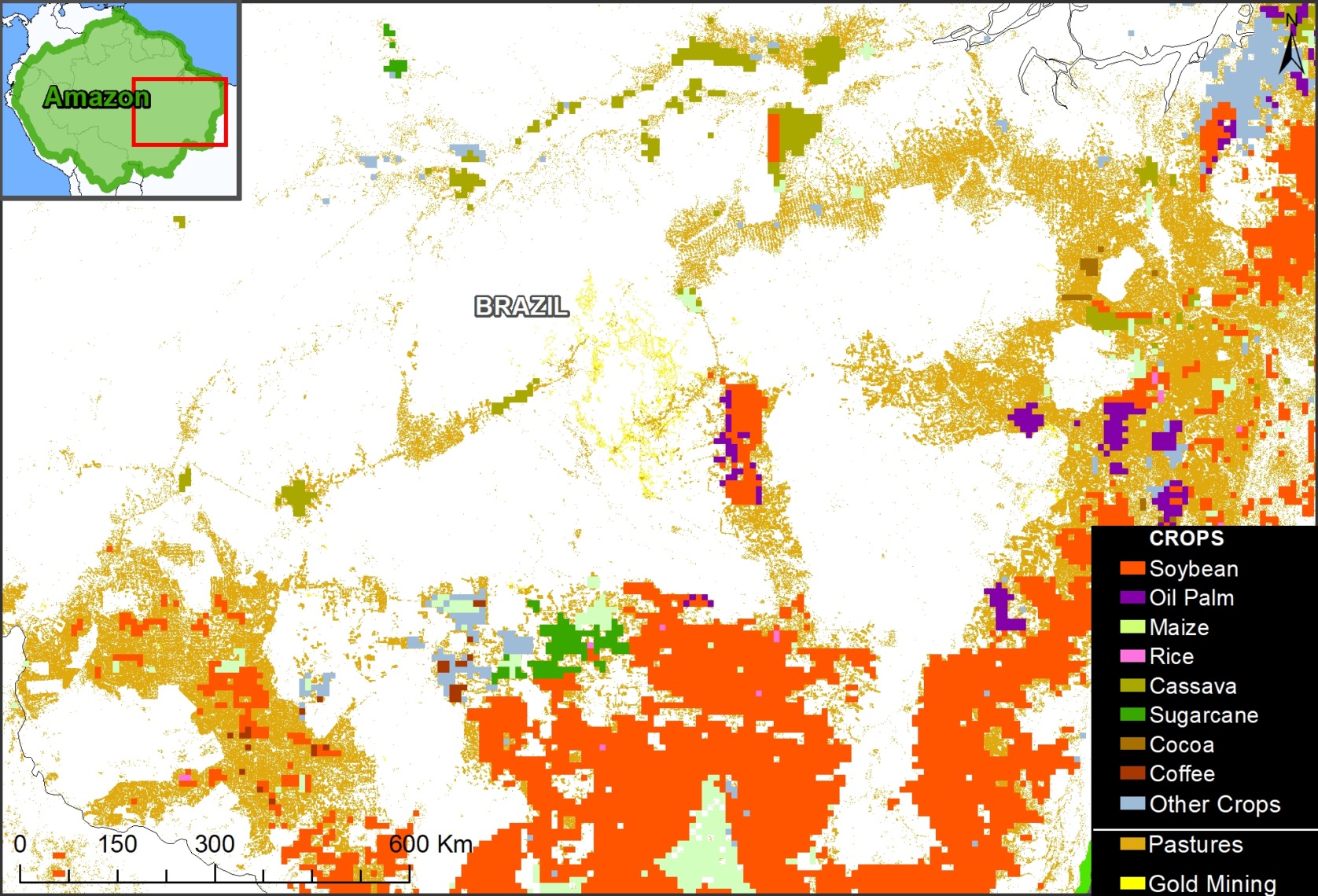
Figure 1. Example of the merged agricultural and pasture data in a section of the Brazilian Amazon. Data: IFRI/SPAM, Lapig/UFG, Mapbiomas, AMW, ACA/MAAP.

A burst of new data and online visualization tools are revealing key land use patterns across the Amazon, particularly regarding the critical topic of agriculture. This type of data is particularly important because agriculture is the leading cause of overall Amazonian deforestation.

These new datasets include:

  • Crops. The International Food Policy Research Institute (IFPRI), a leading agriculture and food systems research authority, recently launched the latest version of their innovative crop monitoring product, the Spatial Production Allocation Model (SPAM).1 This latest version, developed with support from WRI’s Land & Carbon Lab, features spatial data for 46 crops, including soybean, oil palm, coffee, and cocoa. This data is mapped at 10-kilometer resolution across the Amazon and updated through 2020.2
    j
  • Cattle pasture. The Atlas of Pastures,3 developed by the Federal University of Goiás, facilitates access to data regarding Brazilian cattle pastures generated by MapBiomas. This data is mapped at 30-kilometer resolution and updated through 2022. We use Collection 5 from Mapbiomas for the rest of the Amazonian countries.4
    j
  • Gold mining. New mining data is included for additional context. Amazon Mining Watch uses machine learning to map open-pit gold mining.5 This data is mapped at 10-kilometer resolution across the Amazon and updated through 2023.

We merged and analyzed these new datasets to provide our first overall estimate of Amazonian land use, the most detailed effort to date across all nine countries of the biome. Figure 1 shows an example of this merged data in a section of the Brazilian Amazon.

Below, we present and illustrate the following major findings across the Amazon, and then zoom in on several regions across the Amazon to show the data in greater detail.

Major Findings

The Base Map illustrates several major findings detailed below.
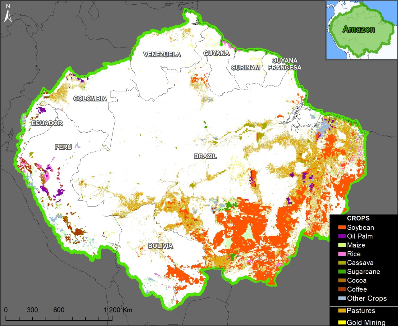
Base Map. Overview of the merged datasets noted above for crops, pasture, and gold mining. Double-click to enlarge. Data: IFRI/SPAM, Lapig/UFG, Mapbiomas, AMW, ACA/MAAP.

1) Crops
We found that 40 crops in the SPAM dataset overlap with the Amazon, covering over 106 million hectares (13% of the Amazon biome).

Soybean covers over 67.5 million hectares, mostly in southern Brazil and Bolivia. Maize covers slightly more area (70 million hectares) but we consider this a secondary rotational crop with soy (thus, there is considerable overlap between these two crops).

Oil palm covers nearly 8 million hectares, concentrated in eastern Brazil, central Peru, northern Ecuador, and northern Colombia.

In the Andean Amazon zones of Peru, Ecuador, and Colombia, cocoa covers over 8 million hectares and the two types of coffee (Arabica and Robusta) cover 6.7 million hectares.

Other major crops across the Amazon include rice (13.8 million hectares), sorghum (10.9 million hectares), cassava (9.8 million hectares), sugarcane (9.6 million hectares), and wheat (5.8 million hectares).

2) Cattle Pasture
Cattle Pasture covers 76.3 million hectares (9% of the Amazon biome). The vast majority (92%) of the pasture is in Brazil, followed by Colombia and Bolivia.

3) Crops & Cattle Pasture
Overall, accounting for overlaps between the data, we estimate that crops and pasture combined cover 115.8 million hectares. This total is the equivalent of 19% of the Amazon biome.

In comparison, open-pit gold mining covered 1.9 million hectares (0.23% of the Amazon biome).

Zooms across the Amazon

Eastern Brazilian Amazon

Figure 2 shows the transition from the soy frontier to the cattle pasture frontier in the eastern Brazilian Amazon. Also note a mix of other crops, such as oil palm, sugarcane, and cassava, and some gold mining.

Figure 2. Eastern Brazilian Amazon. Data: IFRI/SPAM, Lapig/UFG, Mapbiomas, AMW, ACA/MAAP.

Andean Amazon (Peru and Ecuador)

Figure 3. Andean Amazon. Data: IFRI/SPAM, Lapig/UFG, Mapbiomas, AMW, ACA/MAAP.

The land use patterns are quite different in the Andean Amazon regions of Peru and Ecuador.

Figure 3 shows, that instead of soy and cattle pasture, there is instead oil palm, rice, coffee, and cocoa.

Also note the extension of the cattle pasture frontier in the western Brazilian Amazon, towards Peru and Bolivia.


Northeast Amazon (Venezuela, Guyana, Suriname, French Guiana)

Figure 4 shows the general lack of crops in the core Amazon regions Guyana, Suriname, and French Guiana, which is surely a major factor they are all considered High Forest cover, Low Deforestation countries (HFLD). In contrast, note there is abundant gold mining activity throughout this region.

Figure 4. Northeastern Amazon. Data: IFRI/SPAM, Lapig/UFG, Mapbiomas, AMW, ACA/MAAP.

Methods

For the SPAM data, we used the physical area, which is measured in a hectare and represents the actual area where a crop is grown (not counting how often production was harvested from it). We only considered values ​​greater than or equal to 100 ha per pixel.

For the Base Map, due to their importance as primary economic crops, we layered soybean and oil palm as the top two layers, respectively. From there, crops were layered in order of their total physical area across the Amazon. Thus, the full extensions of some crops are not shown if they overlap pixels with other crops that have greater physical area. For overlaps with crops and pasture, we favored the crops.

Notes & Data Sources

1 International Food Policy Research Institute (IFPRI), 2024, “Global Spatially-Disaggregated Crop Production Statistics Data for 2020 Version 1.0” https://doi.org/10.7910/DVN/SWPENT, Harvard Dataverse, V1

Spatial Production Allocation Model (SPAM)
SPAM 2020 v1.0 Global data (Updated 2024-04-16)

2 Note that the spatial resolution is rather low (10-kilometers) so all crop coverage data above should be interpreted as referential only.

3 The Atlas of Pastures (Atlas das Pastagens), open to the public, was developed by the Image Processing and Geoprocessing Laboratory of the Federal University of Goiás (Lapig/UFG), to facilitate access to results and products generated within the MapBiomas initiative, regarding Brazilian pastures.

https://atlasdaspastagens.ufg.br/

4 MapBiomas Collection 5;  https://amazonia.mapbiomas.org/en/

5 See MAAP #212 for more information on Amazon Mining Watch.

Citation

Finer M, Ariñez A (2024) Agriculture in the Amazon: New data reveals key patterns of crops & cattle pasture. MAAP: 214.

MAAP #188: Mennonite Colonies Continue Major Deforestation in the Peruvian Amazon

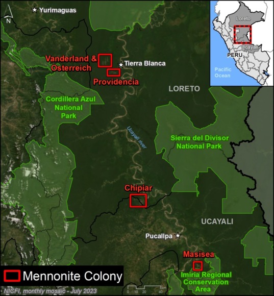
Base Map. Mennonite Colonies in the Peruvian Amazon. Data: ACA/MAAP, SERNANP.

Starting in 2017, new Mennonite colonies began appearing in the Peruvian Amazon, coming from other parts of Latin America in search of new lands.

TheMennonites, a global religious group dating back to the 1600s, often require vast tracts of land to support their characteristic large-scale, industrialized agricultural activity.

In a series of reports, we have demonstrated that the Mennonites have become one of the major deforestation drivers in both the Peruvian and Bolivian Amazon.

Here, we update our findings for Peru for the most recent time period, January 2022 – August 2023.

Our objective is to provide detailed information on the magnitude of deforestation caused by the Menonites in Peru, and to identify the specific colonies where this forest loss is most active now.

Major Findings:

Our analysis has revealed that the Mennonites have now deforested over 7 thousand hectares (7,032 hectares, or 17,376 acres) in the five colonies established since 2017 (Vanderland, Osterreich, Providencia, Chipiar, and Masisea; see Base Map). In addition, we have documented an additional impact of more than 1,600 hectares of burned forests.

Of the total deforestation, more than a third (34.5%) has occurred in the most recent period, from January 2022 to the current date in August 2023 (2,426 hectares, or 5,995 acres).

Below, we detail the deforestation history in each colony, with an emphasis on the most recent loss.

In addition, there is mounting evidence that this massive deforestation is illegal, with numerous ongoing investigations by the Peruvian government (see the Legal Summary, below).

Deforestation in Mennonite Colonies (Peruvian Amazon)

Chipiar Colony

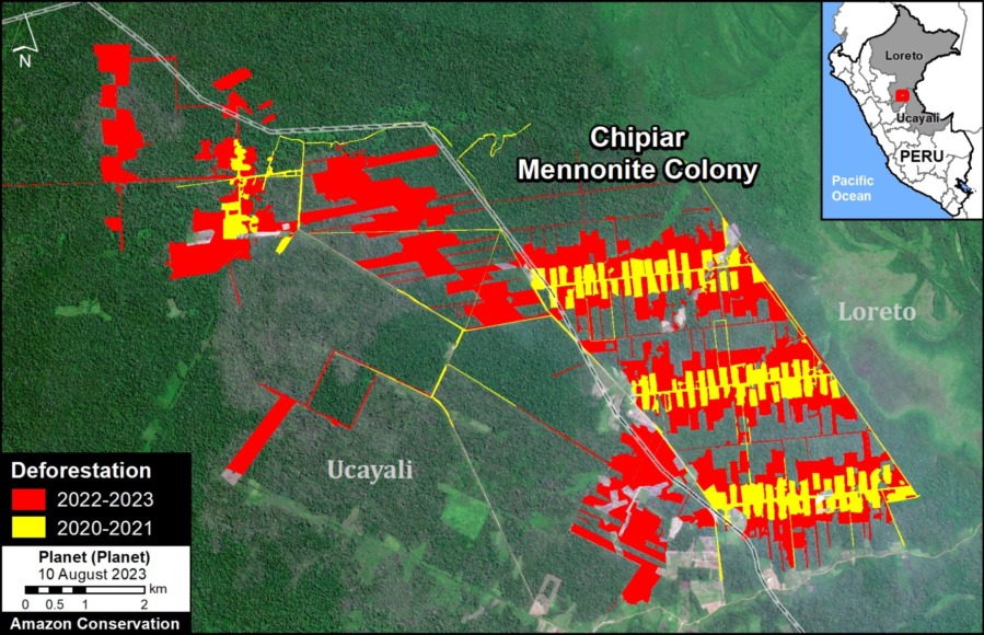
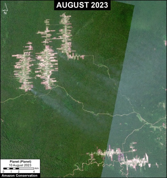
Figure 1. Deforestation in the Chipiar Mennonite colony. Data: ACA/MAAP, Planet.

This colony is located on both sides of the border between the departments of Ucayali and Loreto, originating in the district of Padre Marquez on the Loreto side.

It is the newest colony, where deforestation began in 2020. This deforestation escalated in 2021, peaked in 2022, and continues to expand in 2023.

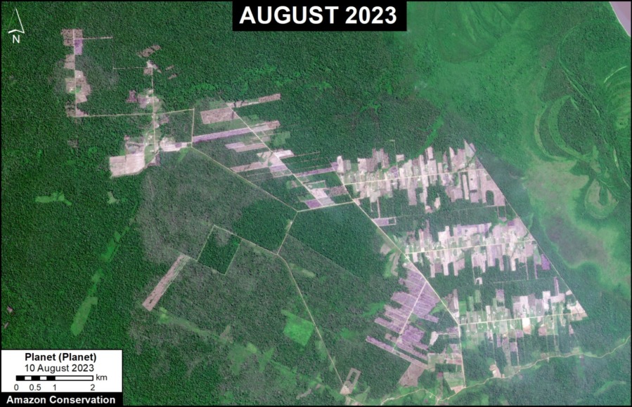
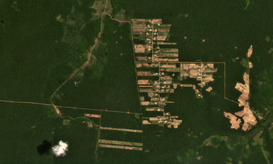
In total, we document the deforestation of 2,221 hectares in the Chipiar colony since 2020 (see image below).

Much of this loss (76%) occurred in the most recent 2022 – 2023 period.

In addition, we estimate the additional degradation of 1,600 hectares by fires that have escaped from the Mennonite plantations into the surrounding forests.


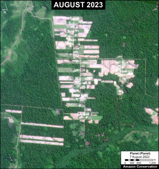
Figure 2. Recent image of deforestation in the Chipiar Mennonite colony. Data: Planet.


Vanderland, Osterreich & Providencia Colonies

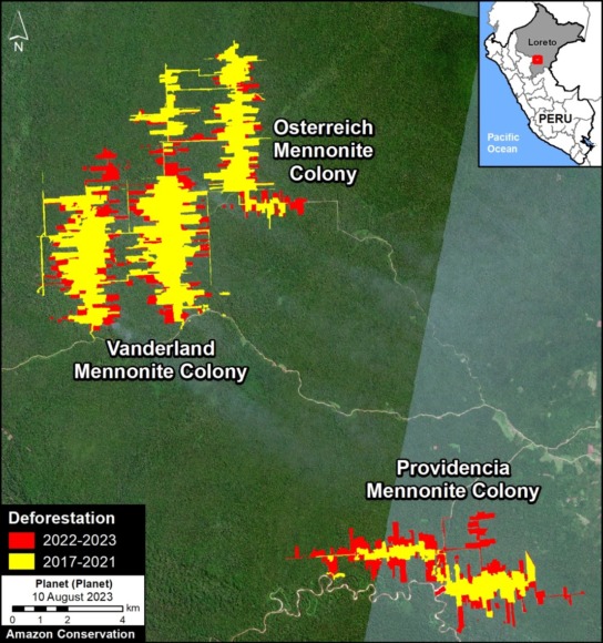
Figure 3. Deforestation in the Mennonite colonies of Tierra Blanca (Vanderland, Österreich and Providencia). Data: ACA/MAAP, Planet.

These three colonies are located near the town of Tierra Blanca, in the Loreto region.

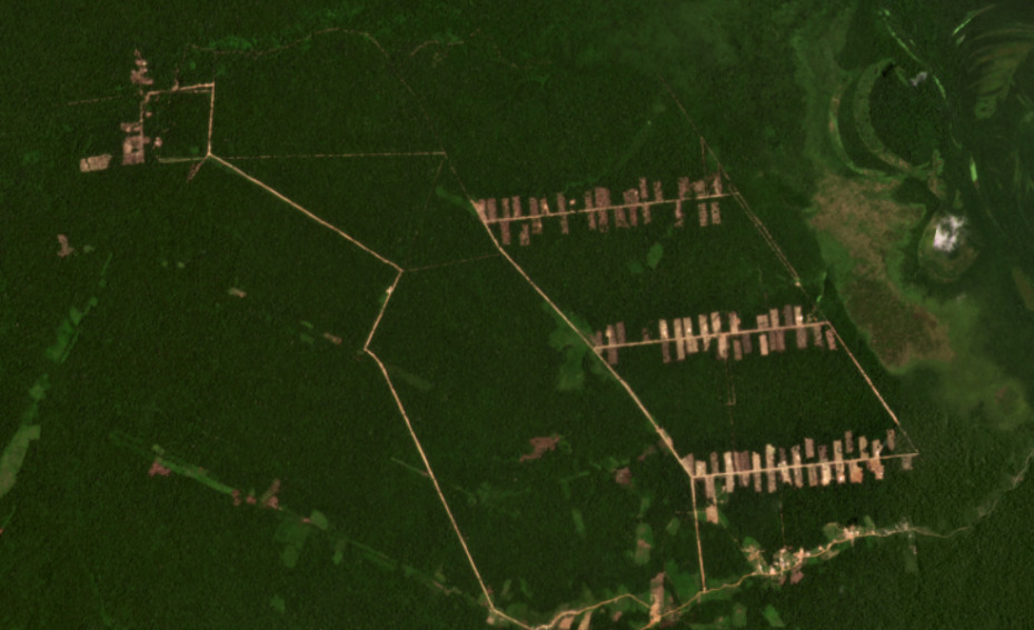
In total, we have documented the deforestation of 3,881 hectares since 2017, with 32.5% occurring in the most recent 2022 – 2023 period (see image below).


Masisea Colony

This colony, located in the Ucayali region, was the first to be established in Peru and was occupied with colonists arriving from Bolivia.

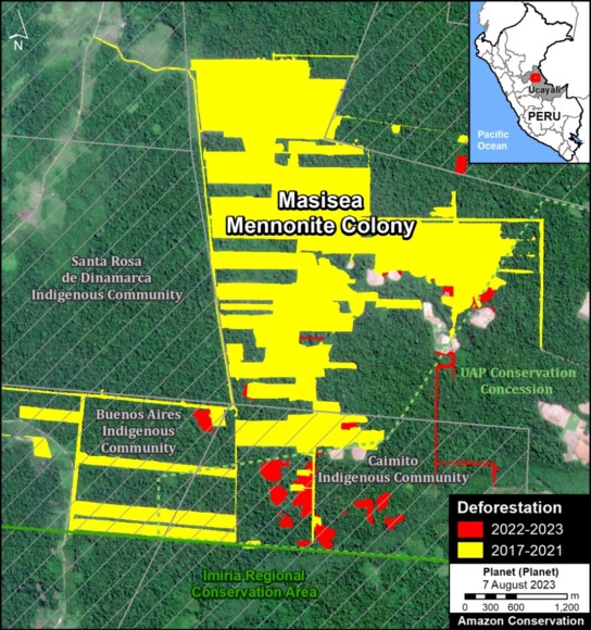
In total, we document the deforestation of 929 hectares in the Masisea colony since 2017 (see image below). Deforestation was highest between 2017 and 2019, and just 6% occurred in the most recent 2022 – 2023 time period.

Figure 4. Recent image of deforestation in the Vanderland, Österreich and Providencia Mennonite colonies. Data: Planet.
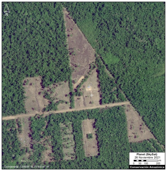
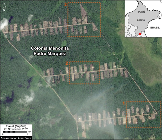
Figure 5. Deforestation in the Masisea Mennonite colony. Data: ACA/MAAP, Planet.


Legal Summary

Figura 6. Imagen reciente de la deforestación en la colonia menonita Masisea. Datos: Planet.

The Specialized Environmental Prosecutor’s Office, known as FEMA (Fiscalia Especializada en Materia Ambiental), is conducting investigations against the Mennonite colonies in each of the three areas:

  • In Masisea, which is the most advanced case, the accusation is for illegal trafficking of timber forest products, crimes against forests in an aggravated form, alteration of the environment or landscape, and crimes against the forests of an indigenous community (tráfico ilegal de productos forestales maderables, delitos contra los bosques en forma agravada y alteración del ambiente o paisaje, y delitos contra los bosques de una comunidad nativa).
    j
  • In the colonies of Tierra Blanca, the accusations include crimes against forests or wooded areas and misuse of agricultural lands (delitos contra los bosques o formaciones boscosas y por utilización indebida de tierras agrícolas).
    j
  • In Chipiar, officially known as the Christian Agricultural Mennonite Colony Gnadenhoff Reinlaender Benboya, the accusation is crime against forests or forest formations in aggravated form (delito contra los bosques o formaciones boscosas en forma agravada).

The Public Prosecutor of the Ministry of the Environment has indicated that all deforestation has occurred without the proper authorization from the relevant state agencies. The regional governments of Ucayali and Loreto have confirmed this assertion, stating that there is no authorization for land use change.

In addition, the National Forest Service (SERFOR) has received five complaints against the Mennonite colonies in the three sectors (two for Masisea, two for Tierra Blanca, and one for Chipiar). These complaints have been forwarded to the respective regional governments and to FEMA in Loreto and Ucayali.

In general, the Mennonites have followed the same pattern in each area: First, there is an irregular purchase of land. Then, they proceed with land use change and deforestation without proper authorization.

In October 2022, the Ucayali Transitory Preparatory Investigation Court for Environmental Crimes (Juzgado de Investigación Preparatoria Transitorio de Delitos Ambientales de Ucayali) ruled in favor of the request of the Attorney General of the Ministry of the Environment, in relation to deforestation in the Chipiar colony. In July 2023, the Second Criminal Appeals Chamber of the Superior Court of Justice of Ucayali (Segunda Sala Penal de Apelaciones de la Corte Superior de Justicia de Ucayali) ratified the immediate suspension of predatory activities of clearing and logging by the colony. According to the judicial order, the members of this Mennonite colony will not be able to use vehicles, machinery or instruments that cause deforestation.

Sources:

Mongabay Latam

https://es.mongabay.com/2022/10/tiruntan-perdio-sus-bosques-tras-la-llegada-de-menonitas-en-peru/

https://es.mongabay.com/2022/02/menonitas-en-peru-tres-colonias-investigadas-por-la-deforestacion-de-casi-4-mil-hectareas-de-bosque-en-la-amazonia/

https://es.mongabay.com/2020/11/menonitas-peru-deforestacion-loreto/

https://es.mongabay.com/2021/04/menonitas-peru-historia-entrega-bosques-masisea/

Ojo Publico

https://ojo-publico.com/ambiente/territorio-amazonas/las-visitas-al-congreso-detras-del-proyecto-que-amenaza-los-bosques

Convoca

https://convoca.pe/investigacion/menonitas-el-grupo-que-convierte-la-fe-religiosa-en-deforestacion-en-la-amazonia-del

https://convoca.pe/investigacion/brechas-legales-permiten-que-los-menonitas-deforesten-la-amazonia-peruana

Actualidad Ambiental

https://www.actualidadambiental.pe/ordena-suspender-depredacion-de-bosques-a-colonia-menonita/

Acknowledgements

We thank colleagues at USAID in Peru and Conservación Amazónica-ACCA for helpful input and comments on this report, and R. McMullen for translation.

This report was prepared with the technical support of USAID through the Prevent Project. Prevent (Proyecto Prevenir in Spanish) works with the Government of Peru, civil society, and the private sector to prevent and combat environmental crimes for the conservation of the Peruvian Amazon, particularly in the regions of Loreto, Madre de Dios, and Ucayali.

Disclaimer: This publication is made possible by the generous support of the American people through USAID. The contents are the sole responsibility of the authors and do not necessarily reflect the views of USAID or the United States Government.

Citation

Finer M, Mamani N (2023) Mennonite Colonies Continue Major Deforestation in the Peruvian Amazon. MAAP: 188.

MAAP #180: Mennonites & Soy Deforestation in the Bolivian Amazon

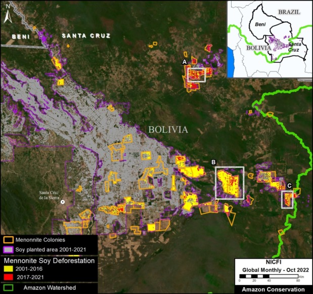
Base Map. Soy deforestation by Mennonite colonies in the Bolivian Amazon.

We continue with the second part in our series on soy deforestation in the Bolivian Amazon.

In the first part, see MAAP #179, we documented the massive soy-driven deforestation of 904,518 hectares (2.2 million acres) between 2001 and 2021 in the Bolivian Amazon.

During this time period, a large number of farming-based Mennonite colonies have been established in the southern Bolivian Amazon, helping drive the increase in soybean expansion in the region.1,2

Here, we incorporate colony location data to estimate the role of Mennonite colonies in this soy deforestation.

In summary, we find that Mennonites have caused a third (33%) of the soy deforestation in the Bolivian Amazon over the past 5 years (see Base Map).

Overall, Mennonites caused nearly a quarter (23%) of the total soy deforestation over the past 20 years (210,980 hectares, or 521,344 acres).


Mennonites & Soy Deforestation in the Bolivian Amazon

We estimate that Mennonite colonies have caused the deforestation of 210,980 hectares (521,344 acres) for soy expansion in the Bolivian Amazon between 2001 and 2021 (see Base Map). This accounts for 23% of the total soybean deforestation in Bolivia over the past 20 years.

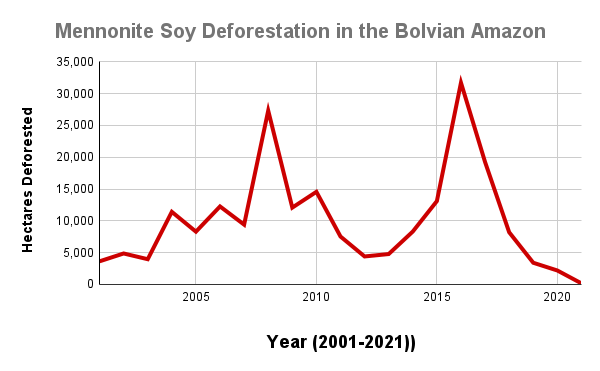
This Mennonite-driven soy deforestation peaked in 2016 (31,728 hectares), following a previous peak in 2008 (see Graph 1). In general, note that Mennonite soy deforestation has been relatively high (>2,000 hectares) every year from 2001 to 2020.

Focusing on just the past five years (2017-21), Mennonites have cleared 33,234 hectares (82,123 acres). This represents an increase to 33% of the total soybean deforestation during this time period.

Graph 1. Soy deforestation caused by Mennonites in the Bolivian Amazon, 2001-2021.

Satellite Images of Mennonite Colonies in the Bolivian Amazon

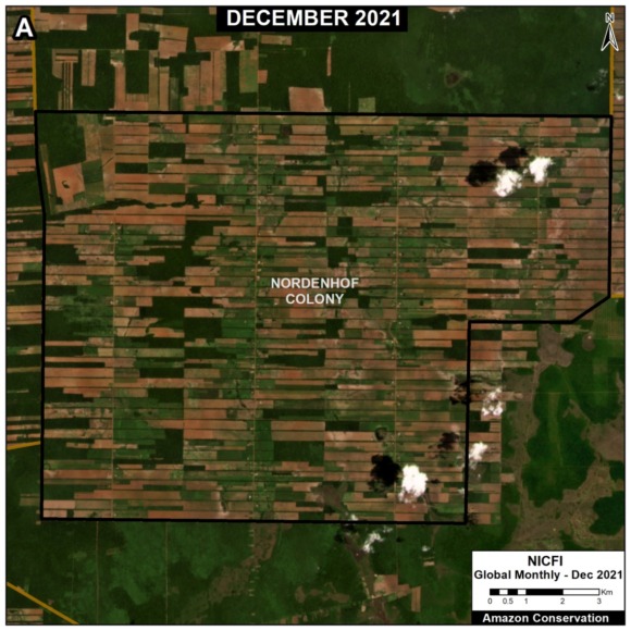
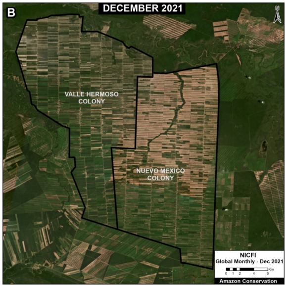
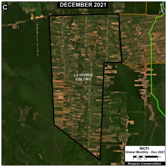
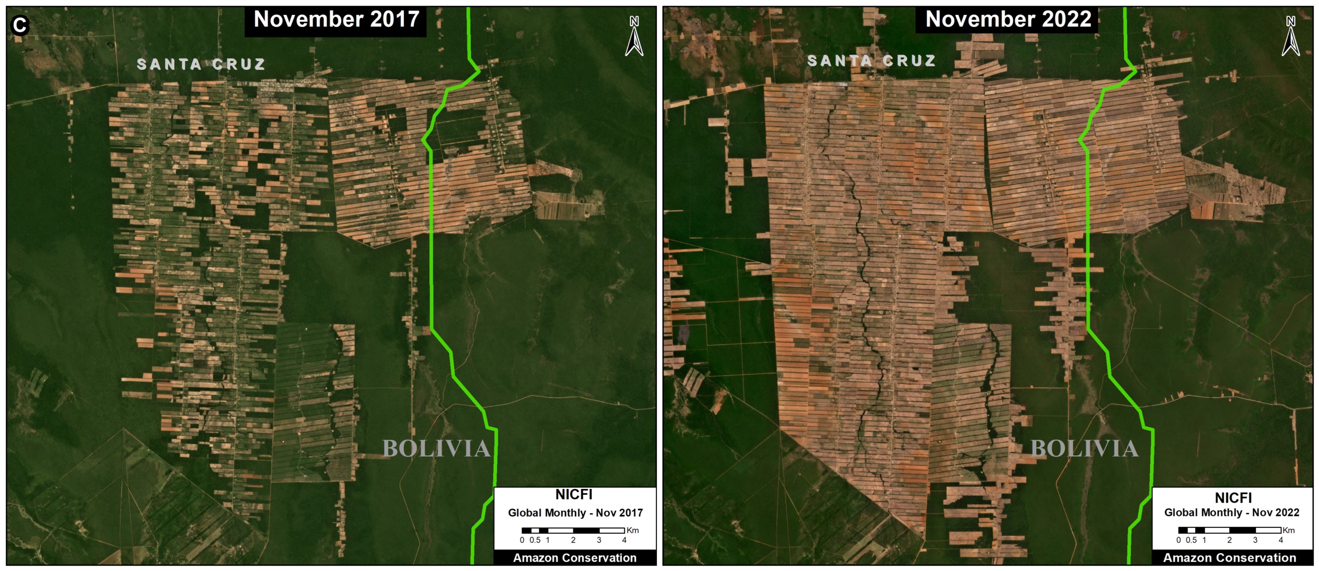
We present a series of recent satellite images showing examples of Mennonite colonies in the Bolivian Amazon. See the Base Map above for the location of the three zooms (A-C). Note that they are made up of highly-organized and connected agricultural plots that have been created following deforestation events over the past 20 years.

Methodology

For this series of reports, we employed a three-part methodology.

First, we mapped out “soy planted area” for 2001 to 2021 based on the data from Song et al 2021. This data is available on the University of Maryland’s GLAD site “Commodity Crop Mapping and Monitoring in South America.”3

Second, on top of the soy planted area noted above, we mapped out forest loss for 2001 to 2021, also based on data from the University of Maryland.4 This served as our estimate of soy-driven deforestation.

Third, on top of the soy planted area noted above, we incorporated an additional dataset from a recent study on the expansion of Mennonite colonies in Latin America.1 Spatial data from this study available here. We then estimated forest loss for these select Mennonite soy areas.

References

1Yann le Polain de Waroux, Janice Neumann, Anna O’Driscoll & Kerstin Schreiber (2021) Pious pioneers: the expansion of Mennonite colonies in Latin America, Journal of Land Use Science, 16:1, 1-17, DOI: 10.1080/1747423X.2020.1855266

2Nobbs-Thiessen, B. (2020). Landscape of Migration. The University of North Carolina Press.

3Song, X.P., M.C. Hansen, P. Potopov, B. Adusei, J. Pickering, M. Adami, A. Lima, V. Zalles, S.V. Stehman, D.M. Di Bella, C.M. Cecilia, E.J. Copati, L.B. Fernandes, A. Hernandez-Serna, S.M. Jantz, A.H. Pickens, S. Turubanova, and A. Tyukavina. 2021. Massive soybean expansion in South America since 2000 and implications for conservation.

4Hansen, M. C., P. V. Potapov, R. Moore, M. Hancher, S. A. Turubanova, A. Tyukavina, D. Thau, S. V. Stehman, S. J. Goetz, T. R. Loveland, A. Kommareddy, A. Egorov, L. Chini, C. O. Justice, and J. R. G. Townshend. 2013. “High-Resolution Global Maps of 21st-Century Forest Cover Change.” Science 342 (15 November): 850–53. Data available from: earthenginepartners.appspot.com/science-2013-global-forest.

Acknowledgements

These reports are part of a series focused on the Bolivian Amazon through a strategic collaboration between the sister organizations Amazon Conservation in Bolivia (ACEAA) and Amazon Conservation in the U.S.

Citation 

Finer M, Ariñez A (2023) Mennonites & Soy Deforestation in the Bolivian Amazon. MAAP #179.

MAAP #179: Soy Deforestation in the Bolivian Amazon

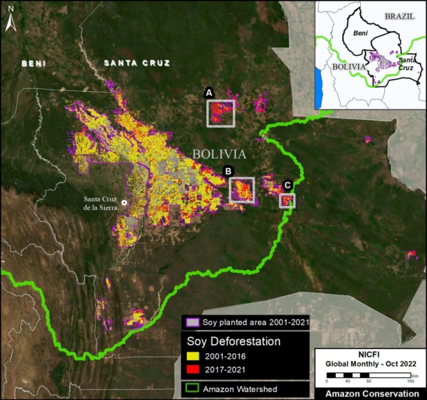
Base Map. Soy-driven deforestation in the Bolivian Amazon, 2001-2021. Click on map to enlarge.

It is generally known that commodities such as oil palm, soy, and cattle are major tropical deforestation drivers, but concise estimates are often difficult.

New satellite-based datasets are improving this situation. Notably, researchers recently published the first overview of soybean plantations for South America.1

Here, we use this data to estimate recent soy-driven deforestation in the Bolivian Amazon.

In the second part of this series, see MAAP #180, we incorporate additional data to estimate the role of Mennonite colonies in this soy deforestation.

In summary, we document the massive soy-driven deforestation of 904,518 hectares (2.2 million acres) between 2001 and 2021 in the Bolivian Amazon (see Base Map).

Of this total, Mennonites have caused 23% (210,980 hectares, or 521,344 acres).


Soy Deforestation in the Bolivian Amazon, 2001 – 2021

Soy has covered 2.1 million hectares of the southern Bolivian Amazon over the past 20 years, with current coverage around 1.2 million hectares.

We documented an extremely high level of soy-driven deforestation in the Bolivian Amazon: 904,518 hectares (2.2 million acres) between 2001 and 2021 (see Base Map above). This is a massive area, similar to the size of the U.S. state of Vermont.

This soy deforestation peaked in 2008 (92,000 hectares), but has been high (>18,000 hectares) every year between 2001 and 2019, meaning this is a long-running and persistent issue.

The vast majority of the total deforestation occurred in the Santa Cruz department, plus a small corner of adjacent Beni department.

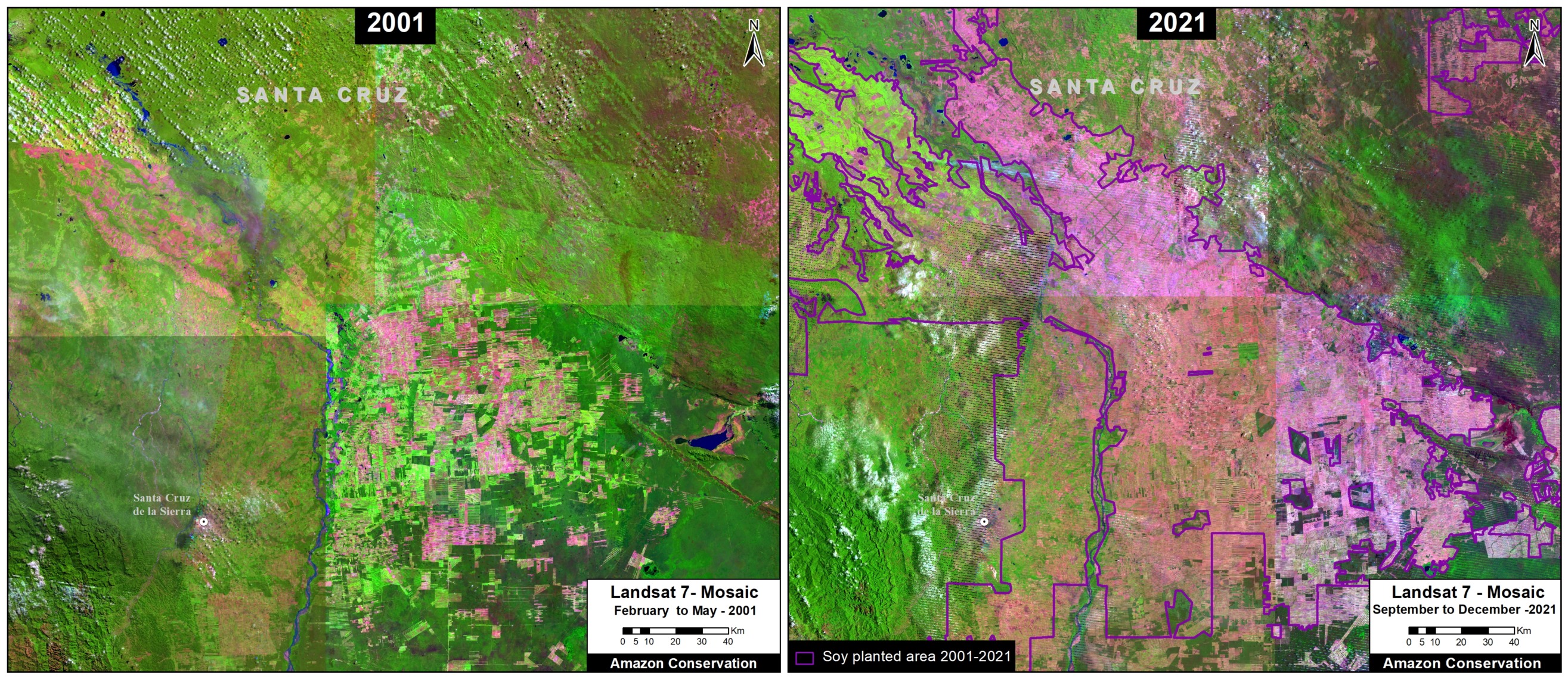
Below, Figure 1 shows the overall massive soy deforestation over the past 20 years in the Bolivian Amazon, comparing 2001 (left panel) with 2021 (right panel).

Figure 1. Soy deforestation in the Bolivian Amazon, 2001 vs 2021.

Soy Deforestation in the Bolivian Amazon, 2017 – 2021

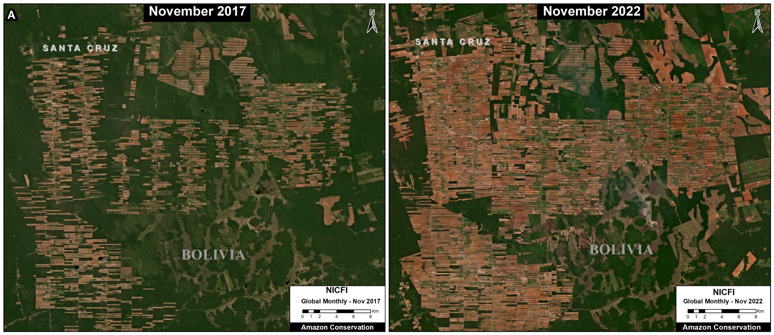
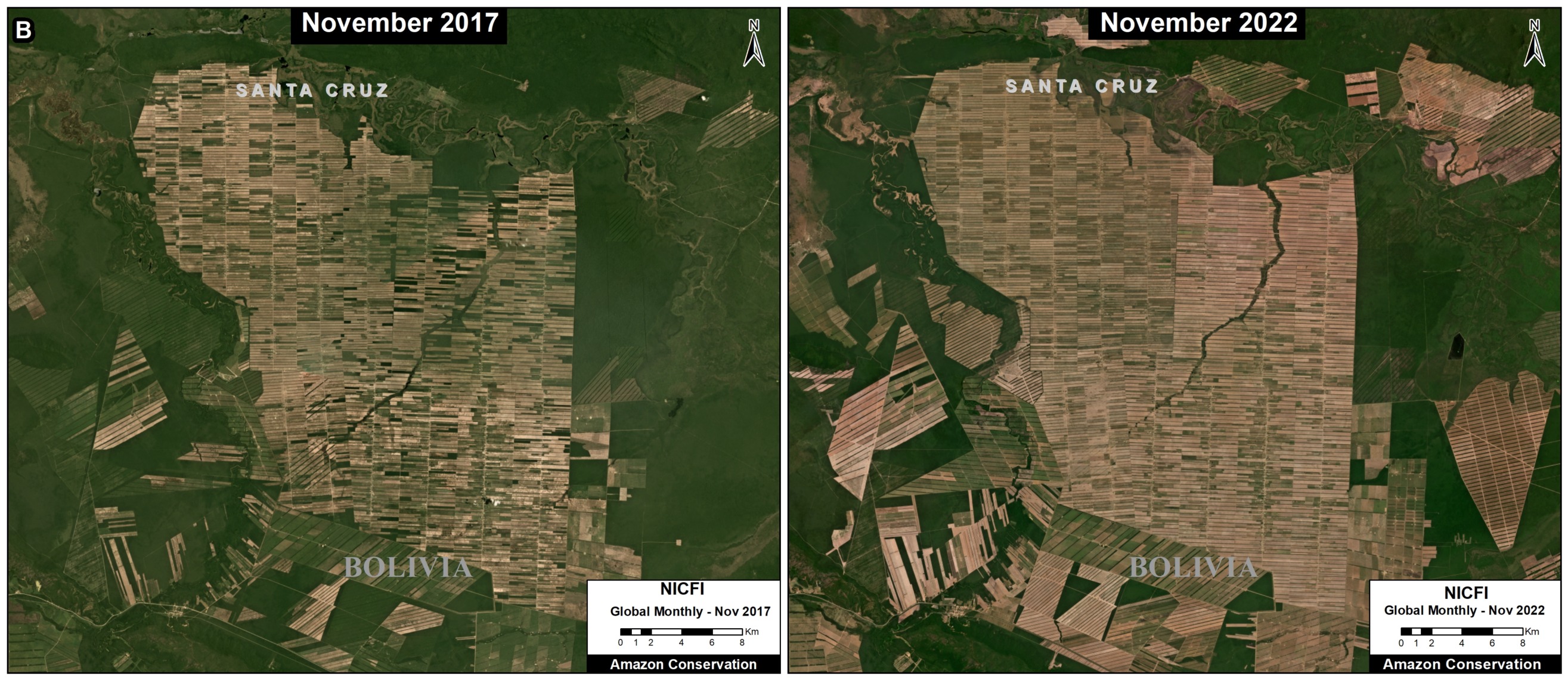
Of the total soy deforestation noted above, 11% (101,188 hectares, or 250,000 acres) occurred in just the past 5 years (2017-21).

Below, Figures 2-4 show examples of this recent soy deforestation, comparing 2017 (left panel) with 2021 (right panel). See the Base Map above for locations of insets A-C.

Figure 2. Soy deforestation in the Bolivian Amazon, 2017 vs 2021.
Figure 3. Soy deforestation in the Bolivian Amazon, 2017 vs 2021.
Figure 4. Soy deforestation in the Bolivian Amazon, 2017 vs 2021.

Methodology

For this series of reports, we employed a three-part methodology.

First, we mapped out “soy planted area” for 2001 to 2021 based on the data from Song et al 2021.1 This data is available on the University of Maryland’s GLAD site “Commodity Crop Mapping and Monitoring in South America.”

Second, on top of the soy planted area noted above, we mapped out forest loss for 2001 to 2021, also based on data from the University of Maryland.2 This served as our estimate of soy-driven deforestation.

Third, on top of the soy planted area noted above, we incorporated an additional dataset from a recent study on the expansion of Mennonite colonies in Latin America. 3 Spatial data from this study available here. We then estimated forest loss for these select Mennonite soy areas. See MAAP #180.

References

1Song, X.P., M.C. Hansen, P. Potopov, B. Adusei, J. Pickering, M. Adami, A. Lima, V. Zalles, S.V. Stehman, D.M. Di Bella, C.M. Cecilia, E.J. Copati, L.B. Fernandes, A. Hernandez-Serna, S.M. Jantz, A.H. Pickens, S. Turubanova, and A. Tyukavina. 2021. Massive soybean expansion in South America since 2000 and implications for conservation.

2Hansen, M. C., P. V. Potapov, R. Moore, M. Hancher, S. A. Turubanova, A. Tyukavina, D. Thau, S. V. Stehman, S. J. Goetz, T. R. Loveland, A. Kommareddy, A. Egorov, L. Chini, C. O. Justice, and J. R. G. Townshend. 2013. “High-Resolution Global Maps of 21st-Century Forest Cover Change.” Science 342 (15 November): 850–53. Data available from: earthenginepartners.appspot.com/science-2013-global-forest.

3Yann le Polain de Waroux, Janice Neumann, Anna O’Driscoll & Kerstin Schreiber (2021) Pious pioneers: the expansion of Mennonite colonies in Latin America, Journal of Land Use Science, 16:1, 1-17, DOI: 10.1080/1747423X.2020.1855266

Acknowledgements

These reports are part of a series focused on the Bolivian Amazon through a strategic collaboration between the sister organizations Amazon Conservation in Bolivia (ACEAA) and Amazon Conservation in the U.S.

Citation

Finer M, Ariñez A (2023) Soy Deforestation in the Bolivian Amazon. MAAP #179.

MAAP #161: Soy Deforestation in the Brazilian Amazon

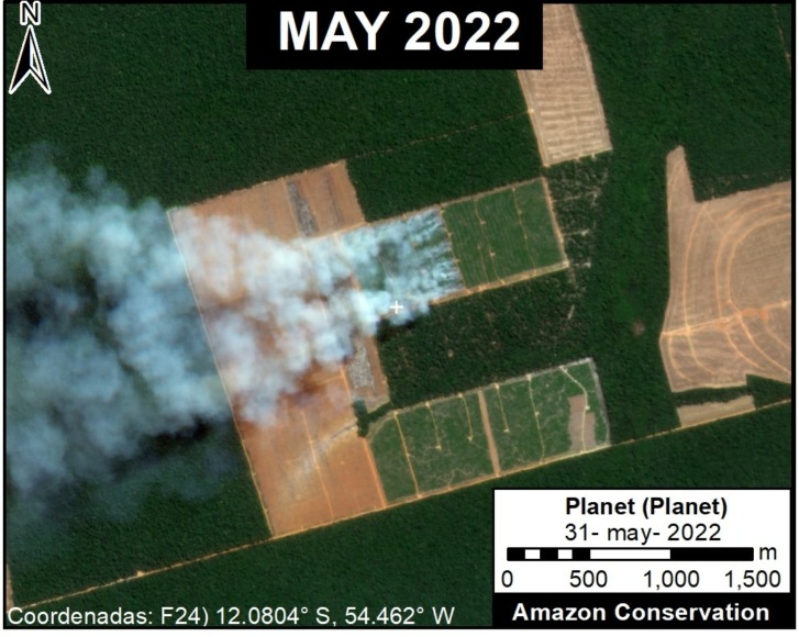
Example of fires burning an area recently deforested for a new soy plantation. Data: Planet.

The Amazon Soy Moratorium has often been credited with significantly reducing soy-related deforestation in the Amazon over the past 15 years.

The Moratorium is a voluntary zero-deforestation agreement in which traders agree not to purchase soy grown on land cleared after 2008.

However, increasing soybean prices may be driving a resurgence of the problem of direct soy deforestation. That is, direct conversion of primary deforestation to soy plantation without passing an initial period as cattle pasture.

A recent report by Global Forest Watch estimated the direct soy deforestation of 29,000 hectares in the Brazilian Amazon in 2019 (Schneider et al 2021).

Here, we report the additional direct soy deforestation of at least 42,000 hectares in the Brazilian Amazon since 2020. All of these areas occurred in the state of Mato Grosso, located on the southeast edge of the Amazon.

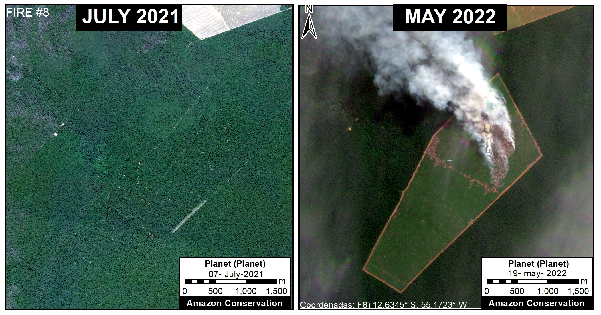
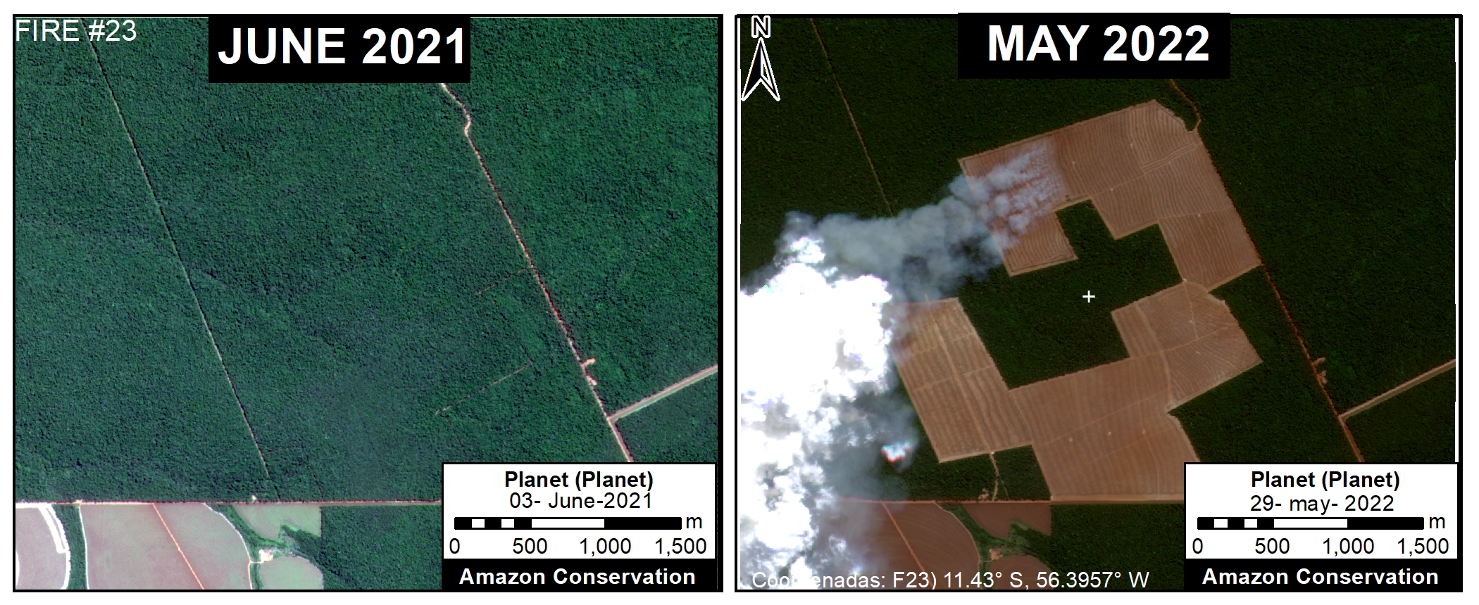
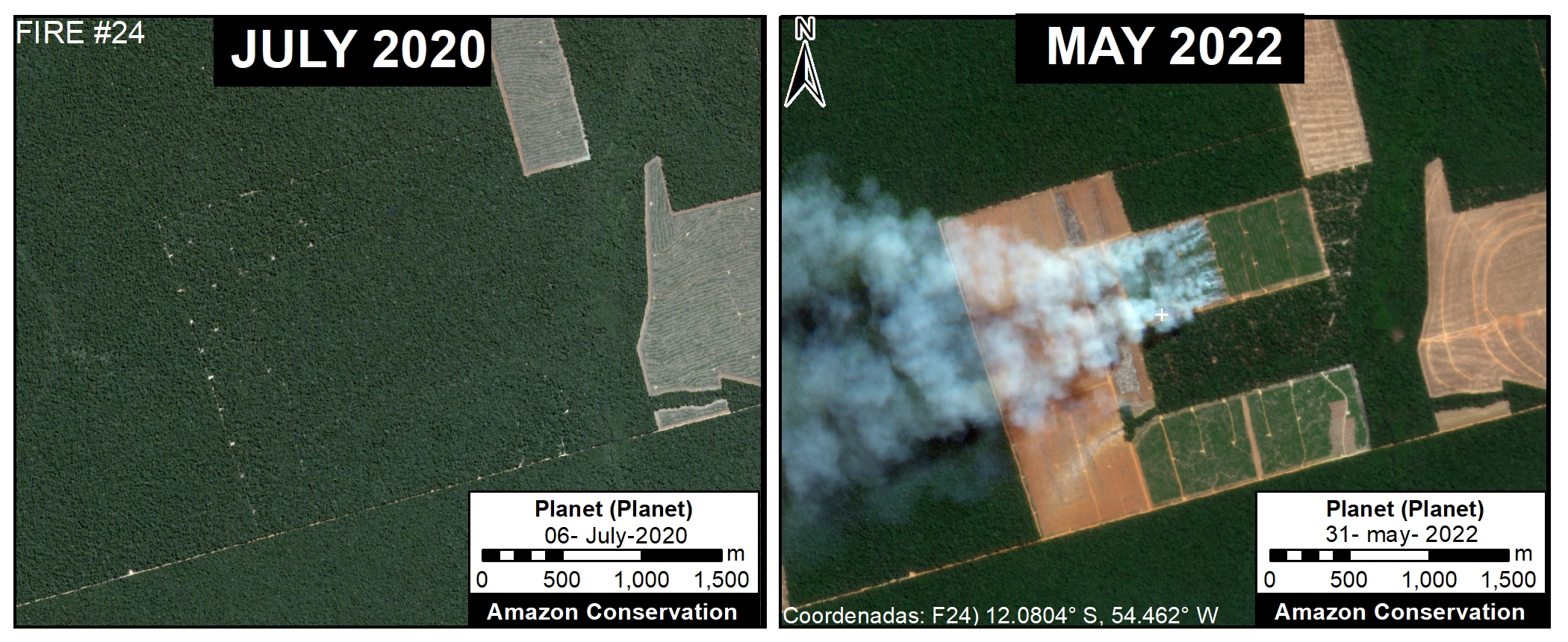
We detected all of these soy plantations based on recent major fire activity (84 major fires), in which the recently deforested area was burned in preparation for the upcoming planting season (see Methodology below for more details).

Below, we show a base map of these recently deforested and then burned areas in the Mato Grosso state of the Brazilian Amazon followed by a series of examples from the satellite imagery.

Base Map – Recent Soy Deforestation in Brazilian Amazon

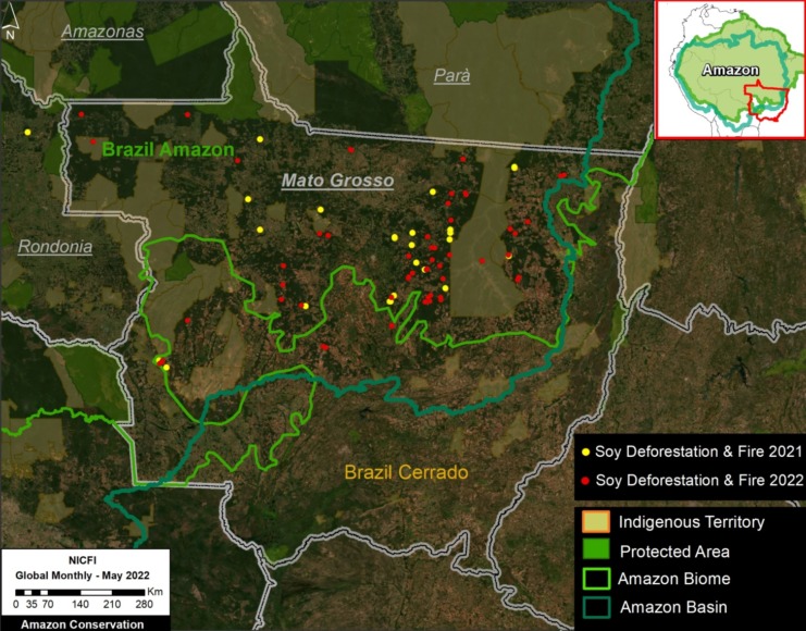
The Base Map below shows the areas, indicated by red dots, of recent direct deforestation for new soy plantations that we detected by monitoring major fire activity in 2022.

Between May 2021 and June 2022, we detected 84 major fires that corresponded to burning areas recently deforested for new soy plantations. These 84 areas, all of which occurred in the state of Mato Grosso, cover an area of 42,000 hectares.

Our geographic focus was the Brazilian Amazon biome in the state of Mato Grosso, as covered by the Amazon Soy Moratorium. For example, we also documented extensive direct soy deforestation and fire in the Bolivian Amazon (Santa Cruz department), but we did not include that information here.

Base Map. Recent Soy Deforestation in Brazilian Amazon. Data: ACA/MAAP, NICFI.

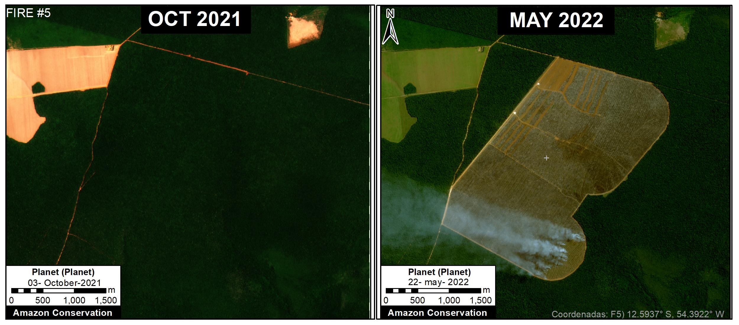
Examples of Deforestation & Fire for New Soy Plantations

As noted above, we detected the direct deforestation for new soy plantations by monitoring major fire activity in 2022. It is assumed that fires are preparing the recently deforested area for upcoming soy planting.

Methodology

We first tracked major fires in 2021 and 2022 using our novel real-time fire monitoring app. See MAAP #118 for more background information about the app and general methodology for detecting major fires based on aerosol emissions. The first major fires were detected in May of each year (2021 and 2022) and we continued collecting data on a daily basis through early July of each year. We monitored fires across the entire Amazon, but this report focuses on Brazil.

For all major fires detected with the app, we confirmed them with high-resolution satellite imagery from Planet. This confirmation was accomplished by visualizing either smoke plumes the day of the fire or burned areas in subsequent days after the fire.

All confirmed fires were assigned a category based on likely direct fire type or driver. These categories include 1) burning area recently deforested for new soy plantation, burning area recently deforested for new cattle pasture, and burning grasslands embedded in the larger rainforest matrix. On rarer occasions, one of these fire types may escape into the surrounding forest, making it an actual forest fire.

Specifically, the soy-related fires were defined as those burning recently deforested areas (that is, areas cleared since 2020) that had a distinctive linear pattern seemingly designed for organized crop agriculture. Most of the newly identified soy areas were also adjacent to existing soy plantations. In other words, the soy deforestation and fire pattern were visually quite distinct from cattle-related and grassland fires. Local experts have informed us that the fires are likely prepping the recently deforested area for the upcoming soy planting season. For all determined direct soy-related fires, we estimated the burned area using the spatial measurement tools in Planet Explorer and entered it into a database. We noted that in July of both years, the fires shifted away from soy and more towards cattle areas.

References

Martina Schneider, Liz Goldman, Mikaela Weisse, Luiz Amaral and Luiz Calado (2021) The Commodity Report: Soy Production’s Impact on Forests in South America. Link: https://www.globalforestwatch.org/blog/commodities/soy-production-forests-south-america/

X.-P. Song, M.C. Hansen, P. Potapov, et al (2021). Massive soybean expansion in South America since 2000 and implications for conservation. Nature Sustainability. Link: https://www.nature.com/articles/s41893-021-00729-z

Acknowledgements

We thank V. Silgueiro and R. Carvalho from the organization Instituto Centro de Vida (ICV) for helpful information and comments related to this report.

Citation

Finer M, Ariñez A (2022) Soy Deforestation in the Brazilian Amazon. MAAP: #161.

MAAP #149: Mennonite Colonies Continue Major Deforestation in Peruvian Amazon

Recent deforestation associated with the newest Mennonite colony “Padre Marquez”. Data: Planet

The Mennonites, a religious group often associated with agricultural activity, have become one of the major deforestation drivers in the Peruvian Amazon.

In October 2020, we reported the deforestation of over 3,400 hectares across three new colonies established.

Here, we show that in 2021 the Mennonites have established a fourth colony (over 400 hectares) and continued expansion of the first three colonies.

In total, we have now documented the deforestation of 3,968 hectares (9,805 acres) across four new colonies established in the Peruvian Amazon since 2017, making it the new leading cause of large-scale deforestation in Peru.

Moreover, there are strong indications that much of this deforestation is illegal (see MAAP #127).

Below, we present the following:

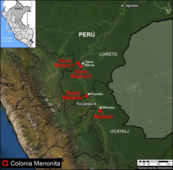
  • An updated Base Map showing the location of the four new Mennonite colonies in the Peruvian Amazon.
    p
  • A series of satellite images showing the most recent deforestation in the newest colony (referred to here as “Padre Marquez”).
Updated Base Map showing the location of the four major new Mennonite Colonies in the Peruvian Amazon. Data: MAAP.

Base Map

The Base Map shows the location of the four major Mennonite colonies in the Peruvian Amazon.

The newest colony is referred to here as “Padre Marquez,” named for a nearby town. Note that it is located about halfway between the other colonies (Tierra Blanca to the north and Masisea to the south.

Of the total deforestation (3,968 hectares):

  • 66% (2,628 ha) is in the Tierra Blanca colonies in Loreto;
  • 23% (918 ha) is in Masisea colony in Ucayali;
  • 11% (421) is in the new Padre Marquez colony along the Ucayali/Loreto border.
    k
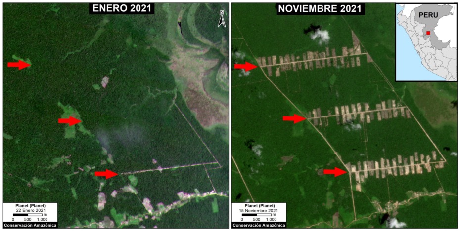
  • 12% occurred in 2021 (495 ha). In addition to the establishment of Padre Marquez, we also detected expansion in the Tierra Blanca and Masisea colonies.

Deforestation 2021

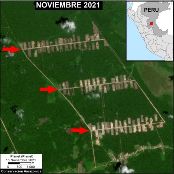
The following image shows the large-scale deforestation of 366 hectares between January (left panel) and November (right panel) 2021 associated with the main section of the new Padre Marquez colony. The red arrows serve as reference points between the two panels. Click to enlarge.

Deforestation between January (left panel) and November 2021 (right panel), associated with the new Padre Marquez colony. Data: Planet, MAAP. Click to enlarge.

Satellite Images of Each Mennonite Colony

Tierra Blanca 1

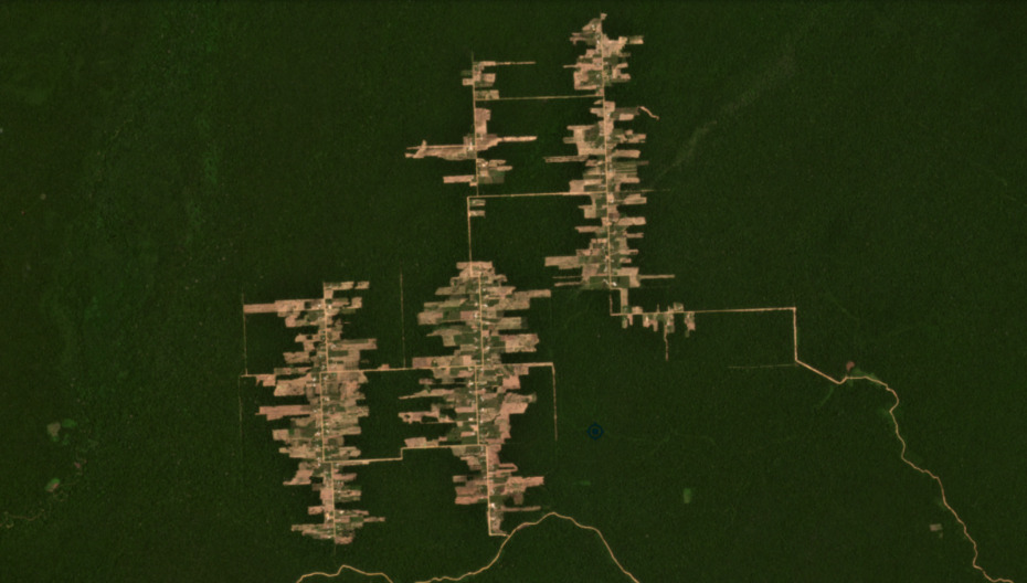
The following image shows the deforestation of 2,200 hectares (5,436 acres) since 2017 in the Tierra Blanca 1 colony (Loreto region). In 2021, this deforestation mostly stopped (only 8 ha).

Tierra Blanca 2

The following image shows the additional deforestation of 428 hectares (1,058 acres) in the nearby Tierra Blanca s colony (Loreto region). In 2021, this deforestation also mostly stopped (15 ha).

Masisea

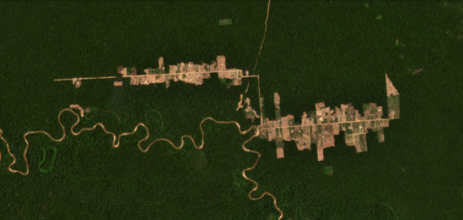
The following image shows the deforestation of 918 hectares (2,268 acres) in the Masisea colony (Ucayali region). In 2021, there was a major expansion to the east (with 47 ha of new deforestation).

Padre Marquez

The following image shows the deforestation of 421 hectares (1,040 acres) in the Padre Marquez colony (Ucayali region), all of which occured in 2021.

Very High-Resolution Images of Padre Marquez colony

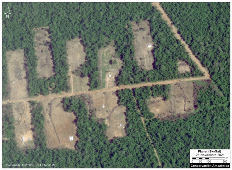
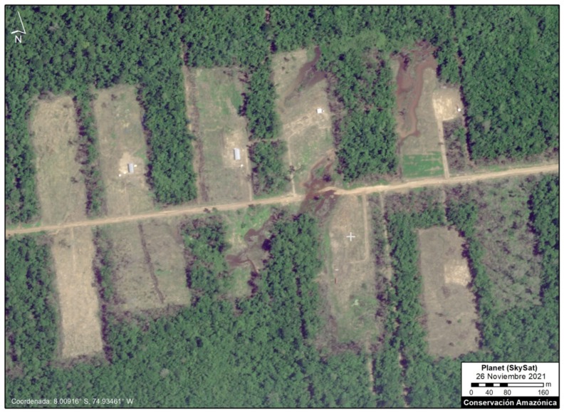
Below, we present a series of very high resolution (0.5 meter) satellite images of the Padre Marquez colony, thanks to the company Planet and their Skysat fleet. The image allows enhanced visualization of some details of the deforested area, such as roads, buildings, and cleared land for likely agricultural activities. Click to enlarge.


Declaration from the Peruvian Ministry of Environment (MINAM):

La destrucción de cientos de hectáreas de bosques en Loreto y en Ucayali causada por las ocupaciones irregulares de colonias menonitas, ha sido priorizada por el MINAM a través de las siguientes acciones:

1. Denuncias penales por afectación de las formaciones boscosas, contra los dirigentes de las colonias menonitas.   Cuatro denuncias en Ucayali y una denuncia penal en Loreto.
2. Medidas cautelares, en el marco de las denuncias penales, para que la autoridad judicial disponga la suspensión de las acciones destructivas y predatorias del bosque.
3. Solicitudes a las entidades de control institucional para la supervisión sobre el ejercicio funcional de las autoridades regionales a cargo del otorgamiento de permisos que afectan el bosque.
4. Además, el MINAM ha venido ejecutando y coordinando diversas acciones con la finalidad que las entidades competentes investiguen, sancionen y paralicen las actividades irregulares de estas personas extranjeras que no solamente han ingresado sin las autorizaciones respectivas para ejecutar actividades económicas, sino que además están dañando ostensiblemente el patrimonio natural peruano.

Acknowledgements

We thank M.E. Gutierrez, E. Ortiz, S. Novoa, R. Catpo, D. Suarez and G. Palacios for helpful comments to earlier versions of this report.

This work was supported by the following major funders: Erol Foundation, Norwegian Agency for Development Cooperation (NORAD), and International Conservation Fund of Canada (ICFC).

Citation

Finer M, Mamani N, Spore J, Suarez D (2021)Mennonite Colonies Continue Major Deforestation in Peruvian Amazon. MAAP: 149.

MAAP #68: 2017 DEFORESTATION HOTSPOTS IN THE PERUVIAN AMAZON (Part 2)

Image 68. Base map. Data: PNCB/MINAM, UMD/GLAD, SERNANP.

In a previous report, MAAP #65, we presented information about deforestation hotspots in 2017 in the Peruvian Amazon, based on early warning alert data from January until mid-July.

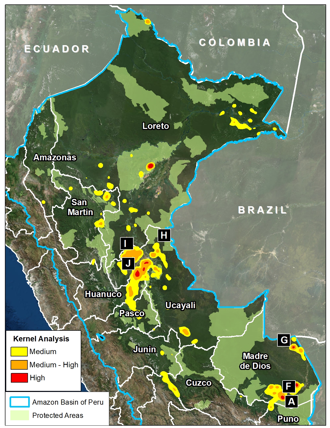
Between July and August, the amount of alerts greatly increased, likely due to arrival of the dry season. Thus, this report includes new updated data until mid-August.*

We find new deforestation hotspots in the regions of Madre de Dios and Ucayali (see base map).** At the national level, we now estimate the forest loss of 111,200 acres (45,000 hectares) thus far in 2017 (thru August 17).***

Below, we present satellite imagery of the following hotspots:

– La Pampa, Madre de Dios (Inset A)
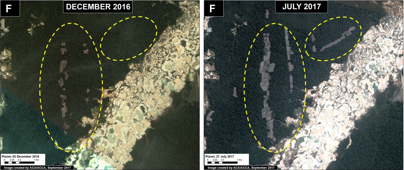
– Guacamayo, Madre de Dios (Inset F)
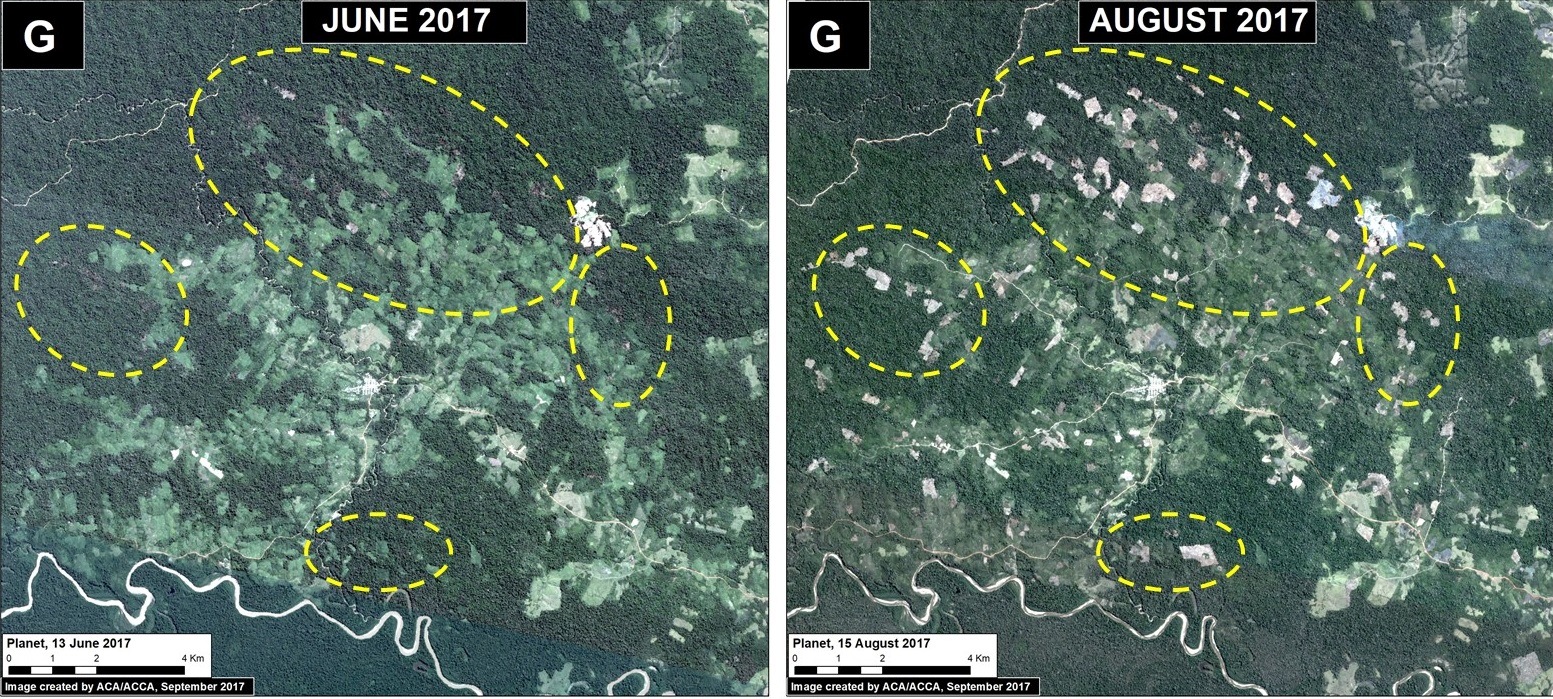
– Iberia, Madre de Dios (Inset G)
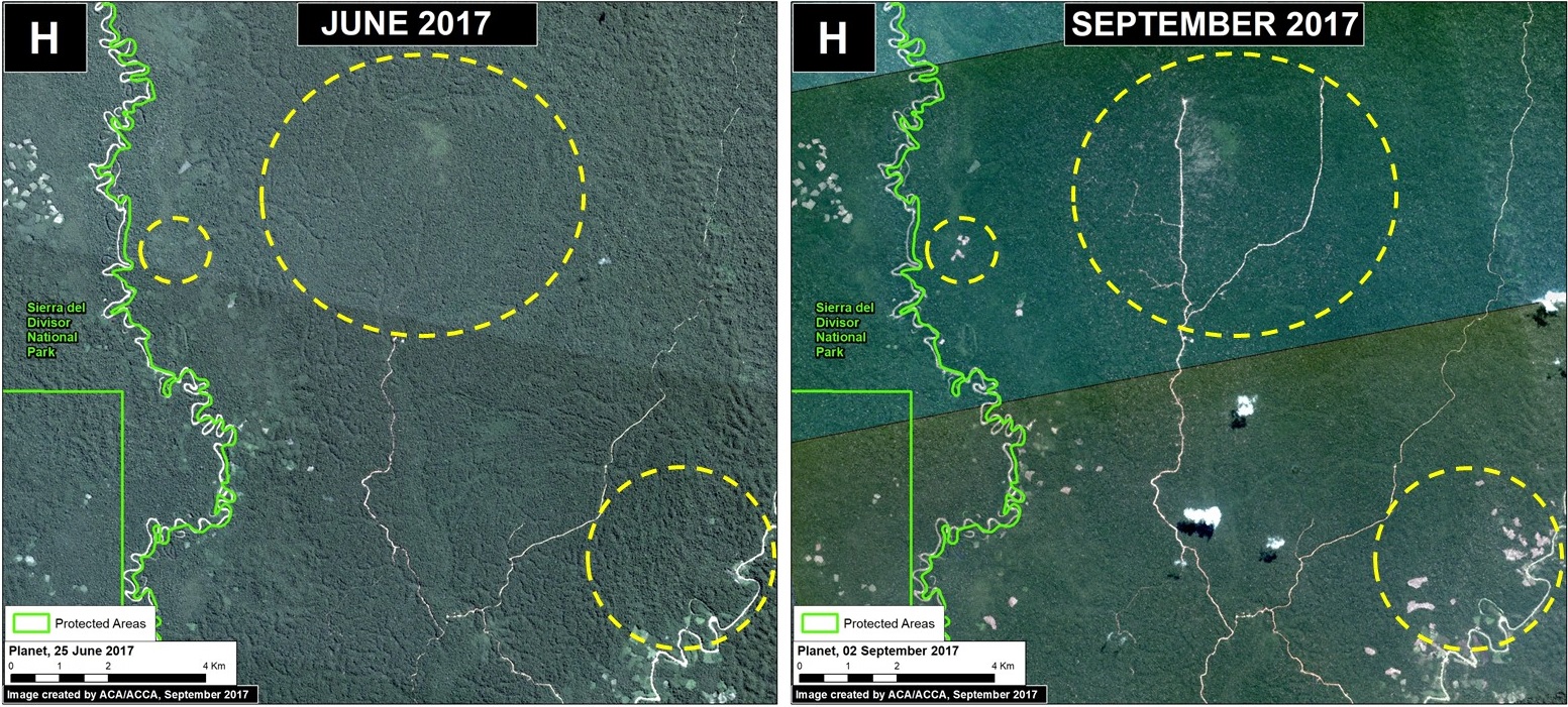
– South of Sierra del Divisor, Ucayali (Inset H)
– Nueva Requena, Ucayali (Inset I)

**The data were generated by the National Program of Forest Conservation for Climate Change Mitigation, Peruvian Ministry of Environment (PNCB/MINAM).

**See Hotspots A-E in MAAP #65

***We emphasize that our calculations are just estimates. Official forest loss data are produced annually by the Peruvian Ministry of Environment.


La Pampa, Madre de Dios (Inset A)

Illegal gold mining deforestation continues to expand in the buffer zone of Tambopata National Reserve in the southern Peruvian Amazon. The Peruvian Government has conducted several interventions this year, most notably in July. However, between July and August we documented the additional loss of 67 acres (27 hectares), increasing the 2017 total deforestation in this zone to 1,280 acres (517 hectares). Image 68a is a GIF illustrating the gold mining deforestation from January to September 2017.

Image 68a. Data: Planet

Guacamayo, Madre de Dios (Inset F)

North of La Pampa, in another gold mining zone, known as Guacamayo, we have documented the rapid deforestation of 182 acres (74 hectares). This newly deforested area is located next to the mining zone (within a forestry concession), and appears to be caused by agricultural activity.

Image 68f. Data: Planet

Iberia, Madre de Dios (Inset G)

Around the  town of Iberia, located along the Interoceanica highway near the border with Brazil, has recently become a major deforestation hotspot (see MAAP #28 and MAAP #47). Between June and August 2017, we detected the deforestation of 1,075 acres (435 hectares). Much of this deforestation is within forestry concessions, indicating that the concessions have been invaded. The deforestation appears  to be caused by agriculture (according to local sources, the clearing is for corn plantations).

Image 68g. Data: Planet.

South of Sierra del Divisor, Ucayali (Inset H)

In the central Peruvian Amazon, just south of Sierra del Divisor National Park, we detected the new construction of 25 km of logging roads in the forestry concessions surrounding the park. We also detected the deforestation of 138 acres (56 hectares), close to the National Park’s limit for what appears to be agricultural activity.

Image 68h. Data: Planet, SERNANP

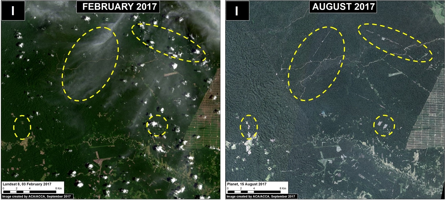
Nueva Requena, Ucayali (Inset I)

Also in the central Peruvian Amazon, in the Nueva Requena district near two controversial oil palm plantations (MAAP #41), we detected the deforestation of 1,130 acres (457 hectares) in state forestry lands (known as Permanent Production Forest). This includes 26 km of new logging and agricultural roads. It is important to note that this area was recently in the news regarding the killing of six farmers over land rights dispute.

Image 68i. Data: Planet

References

Planet Team (2017). Planet Application Program Interface: In Space for Life on Earth. San Francisco, CA. https://api.planet.com.

Citation

Finer M, Novoa S, Olexy T (2017) 2017 Deforestation Hotspots in the Peruvian Amazon (Part 2). MAAP: 68.