MAAP #157: New and Proposed Roads Across the Western Amazon

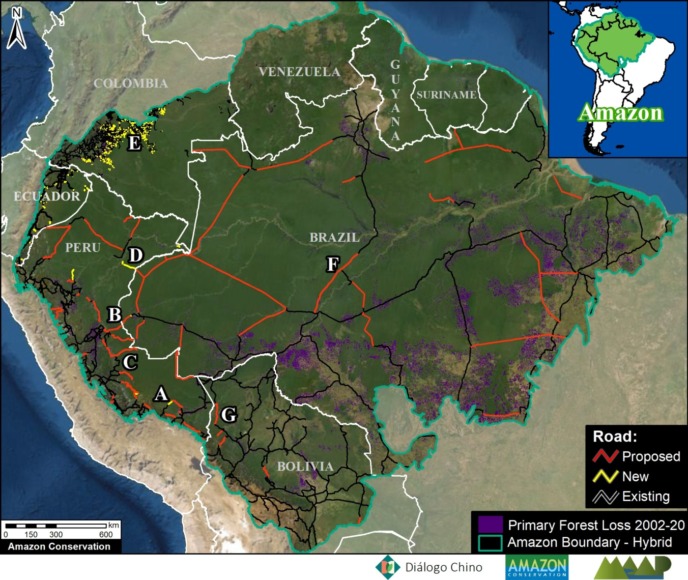
Amazon Roads Base Map 1. Data: ACA/MAAP, MTC, MINAM, MI, ABT, GAD Napo, FCDS, EcoCiencia, Diálogo Chino, CSF, RAISG, ACCA, ACEAA.

Extensive deforestation, especially along the major road networks, has shockingly turned the eastern Brazilian Amazon into a net carbon source (see MAAP #144).

Fortunately, the greater Amazon across all nine countries is still a net carbon sink, largely thanks to the still intact core of the western Amazon.

The biggest long-term threat to this core Amazon is likely new roads, as they are a leading cause of opening up vast and previously remote areas to deforestation and degradation (Vilela et al 2020).

Here, we present an initial analysis of new and proposed roads across the western Amazon.

Although it’s difficult to predict what proposed projects are actually likely to eventually move forward, we do find the potential of a major road expansion across the core western Amazon (see Base Map 1).

Moreover, even by just focusing on the most advanced or actively discussed projects, we find the risk of major negative impact.

Below, we discuss our initial Amazon Roads Base Map and present a series of zooms showing the primary forest at risk if select road projects move forward.

Amazon Roads Base Map

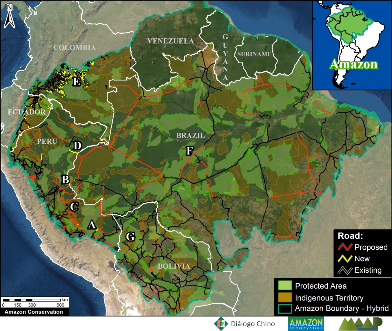
Base Map 2 highlights new, proposed, and existing roads (red, yellow, and black lines, respectively), in relation to protected areas and indigenous territories for context. We focus on the still largely intact core of the western Amazon (Bolivia, Colombia, Ecuador, Peru, and western Brazil).

Most of the new roads were constructed in the past five years and were digitized from satellite imagery. Note that for some of these new roads, just initial construction of a rough road started and there is still potential for future impacts from road improvement and paving.

Most of the proposed roads were obtained from official government data sets. As noted above, it’s difficult to predict what proposed road projects are actually likely to eventually move forward. Nonetheless, it is clear to see there is the potential to greatly divide the remaining core western Amazon with the portfolio of proposed roads.

Amazon Roads Base Map 2. Data: ACA/MAAP, MTC, MINAM, MI, ABT, GAD Napo, FCDS, EcoCiencia, Diálogo Chino, CSF, RAISG, ACCA, ACEAA.

Zooms of High-Impact New & Proposed Roads

In this section, we focus on the currently most advanced or actively discussed projects (see Letters A-F on Amazon Roads Base Map). We highlight their potential impacts to vast sections of the core western Amazon protected areas and indigenous terrritories.

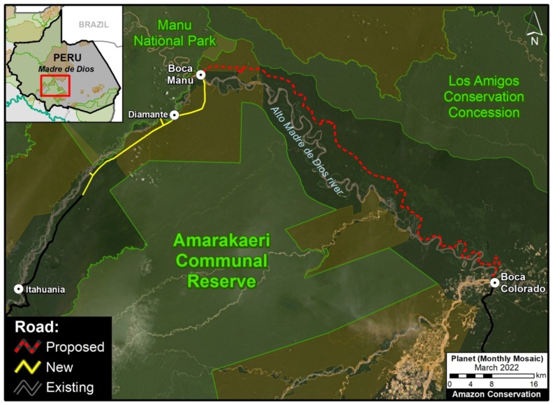
A. Boca Manu Road (Peru)

The new/proposed road that we refer to here as the Boca Manu road would serve as a new connection between Cusco and Madre de Dios regions. It is notable due its sensitive route between Manu National Park and Amarakaeri Communal Reserve to Boca Manu, and from there between Los Amigos Conservation Concession and Amarakaeri Communal Reserve to Boca Colorado. In addition to likely impacting these protected areas and the concession, the road also has the potential to impact the nearby territory of  indigenous groups in voluntary isolation. See this recent report from Diálogo Chino for more information about this road and its status and impacts.

Zoom A. Boca Manu Road. Data: MTC, MINAM, ACA, ACCA, RAISG.

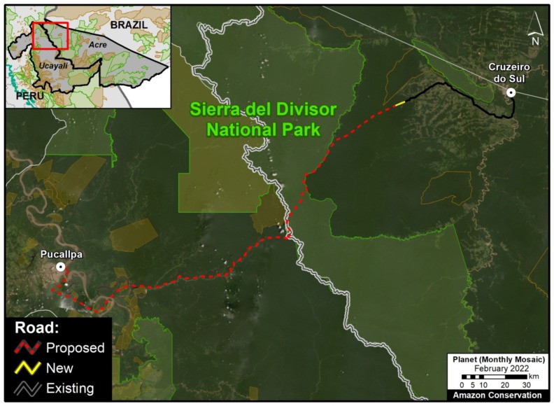
B. Pucallpa – Cruzeiro do Sul Road (Peru – Brazil)

This proposed road would connect the Peruvian city of Pucallpa with the edge of the existing road network in western Brazil, near the town of Cruzeiro do Sul. Although the potential route has several options, it would sure cut through or near Sierra del Divisor National Park in Peru and the adjacent Serra do Divisor National Park in Brazil. This area is characterized by vast primary forests, thus creating a new binational route connecting the deforestation fronts in each country could obviously trigger significant impacts. See this recent report from Diálogo Chino for more information about this road and its status and impacts.

Zoom B. Pucallpa – Cruzeiro do Sul Road. Data: MTC, MINAM, ACA, CSF, Diálogo Chino, RAISG.

C. Yurua Road (Peru)

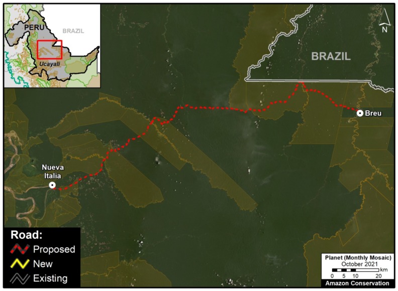
The new/proposed road that we refer to here as the Yurua road would connect the Peruvian towns of Nueva Italia on the Ucayali River and Breu on the Yurua River. This 200 km route was originally built as a logging road in the late 1980s to access remote timber areas in the central Peruvian Amazon, but had fallen into disrepair by the early 2000s. A recent MAAP analysis (see MAAP #146) found that between 2010 and 2021 much of the route had been rehabilitated, triggering elevated deforestation along the way. If this road were ever to be paved then impacts would likely continue to rise, including with native communities along the route. See MAAP #146 for more information about this road and its status and impacts.

Zoom C. Yurua Road. Data: MTC, MINAM, ACA, ACCA, RAISG.

D. Genaro Herrera – Angamos Road (Peru)

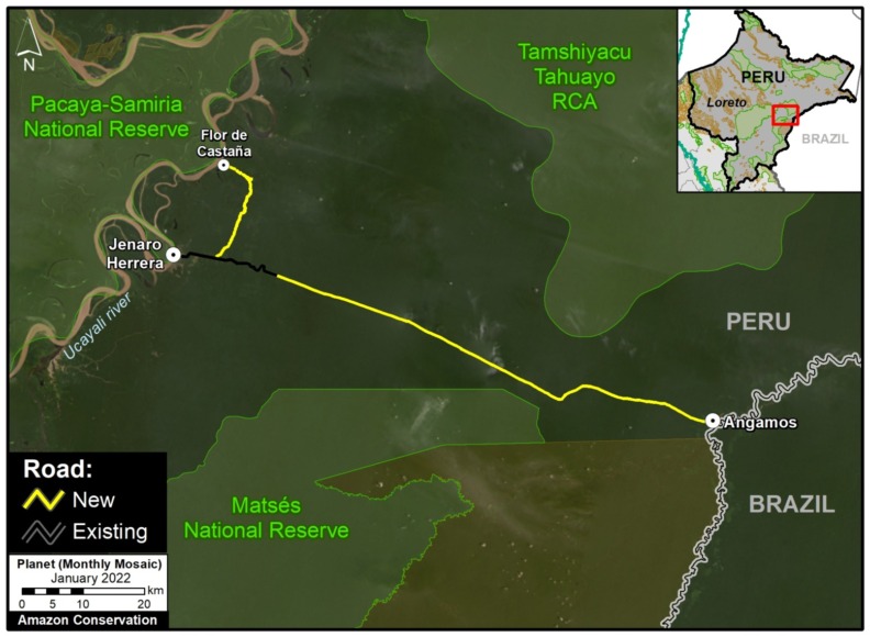
This new/proposed road would build off an old track through the vast forests connecting the northern Peruvian towns of Genaro Herrera and Angamos, in the region of Loreto. In 2021, clearing began along this route, advancing over 100 kilometers from both ends. If completed and paved, the final road project would impact protected areas on both sides (including the Matsés National Reserve to the south) and pose a major threat to indigenous people in voluntary isolation reportedly living to the north. See this recent report for more information about this road and its status and impacts.

Zoom D. Genaro Herrera – Angamos Road. Data: MTC, ACA, RAISG.

E. Cachicamo – Tunia Road (Chiribiquete National Park, Colombia)

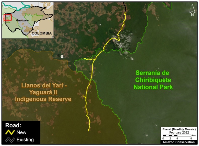
Chiribiquete National Park, located in the heart of the Colombian Amazon, has been experiencing increasing deforestation pressures, partly due to expanding road networks around and even within the park. For example, the Cachicamo-Tunia Road, constructed in 2020, has triggered a new deforestation front in the northwest section of the park. Note this road is also impacting an adjacent Indigenous Reserve.

Zoom E. Cachicamo – Tunia Road. Data: FCDS, RAISG, ACA.

F.  Manaus – Porto Velho Road (BR-319, Brazil)

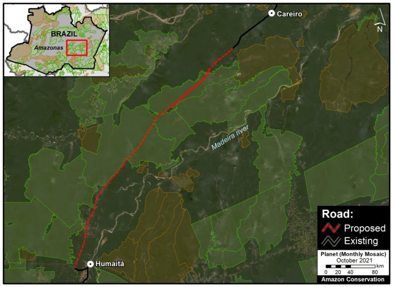
Arguably the most controversial project on the list: paving the middle section of BR-319 in the heart of the Brazilian Amazon. This nearly 900 km road connects the remote city of Manaus (otherwise only reachable by air or water) with the rest of Brazilian road network in Humaitá and Porto Velho to the south. It was built in the early 1970s but abandoned and impassable by the late 1980s, isolating Manaus once again. Since 2015, a basic maintenance program has made the road generally passable, but the main project remains: paving the 400 km middle section that passes through the core western Amazon. This paving would effectively connect Manaus with the existing highways in the south, and most likely trigger massive forest loss by extending the arc of deforestation northwards, including within and around the protected areas that surround the road. This road project has been the subject of numerous recent press reports, including investigative pieces by the Washington Post and El Pais.

Zoom F. Manaus – Porto Velho Road. Data: Ministério da Infraestrutura, ACA, RAISG.

G. Ixiamas – Chivé Road (Bolivia)

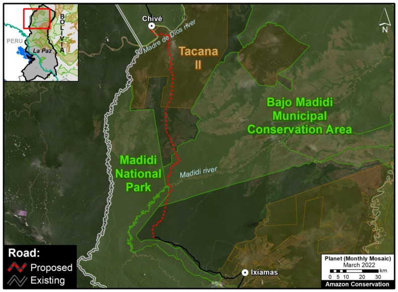
In recent years, Bolivia has been seeking financing for a 250 km road linking the current frontier town Ixiamas with the isolated town Chivé, located near the Peruvian border on the Madre de Dios river. This road would cross extensive tracts of primary Amazon forest and savannah in the north of the La Paz department, including the newly created Bajo Madidi Municipal Conservation Area and the Tacana II indigenous territory.

Zoom G. Ixiamas – Chivé Road. Data: ABT, ACEAA, ACA, RAISG.

Methodology

Our analysis and maps focus on the western Amazon (Bolivia, Colombia, Ecuador, Peru, and western Brazil).

Most of the new roads were constructed in the past five years and were digitized from satellite imagery. Note that for some of these new roads, just initial rehabilitation/improvement of a rough road started and there is still potential for future impacts from paving.

Most of the proposed roads were obtained from official government data sets (and complemented by civil society reports).

We credit the following data sources: Ministerio de Transportes y Comunicaciones (Peru), Geobosques/MINAM (Peru), Ministério da Infraestrutura (Brazil),  Autoridad de Fiscalización y Control Social de Bosques y Tierra – ABT (Bolivia), Gobierno Autonomo Descentralizado Provincial de Napo (Ecuador), Fundación para la Conservación y el Desarrollo Sostenible – FCDS (Colombia), Fundación EcoCiencia (Ecuador), Diálogo Chino, Conservation Strategy Fund, RAISG, Conservación Amazónica – ACCA (Peru), Conservación Amazónica – ACEAA (Bolivia), and Amazon Conservation (digitalization of some new and proposed roads).

Reference:
Vilela et al (2020) A better Amazon road network for people and the environment. PNAS 17 (13) 7095-7102.

Acknowledgments

We especially thank Diálogo Chino for their support of this report. We also thank E. Ortiz, S. Novoa, S. Villacis, D. Larrea, M. Terán, and D. Larrea for helpful comments on earlier drafts of the text and images.

Citation

Finer M, Mamani N (2022) New and Proposed Roads Across the Western Amazon. MAAP: 157.

MAAP #84: New Threats to the Peruvian Amazon (Part 1: Yurimaguas-Jeberos Road)

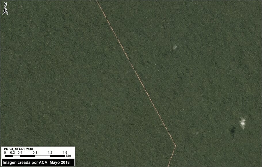
Image A: New Yurimaguas-Jeberos road crossing primary forest. Data: Planet

The efforts and international commitments of the Peruvian Government to reduce deforestation may be compromised by new projects do not have adequate environmental assessment.

In this series, we address the most urgent of these projects, those that threaten large areas of primary Amazonian forest.

We believe that these projects require urgent attention from both government and civil society to ensure an adequate response and avoid irreversible damage. For example, in the case below, it is not known whether there is an environmental impact study.

The first report of this series focuses on a new road (Jeberos – Yurimaguas) that threatens a large expanse of primary forest in the northern Peruvian Amazon (see Image A).


Yurimaguas-Jeberos Road

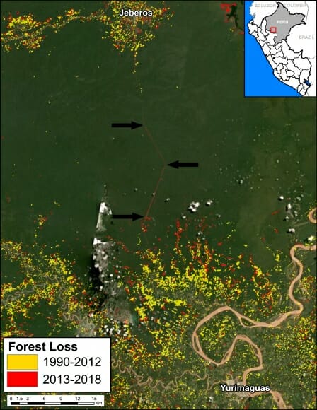
Image B. Data: GLAD/UMD, PNCB/MINAM, Hansen/UMD/Google/USGS/NASA

Early warning forest loss alerts (GLAD alerts from the University of Maryland and Global Forest Watch) have detected the construction of a new road between the city of Yurimaguas and the town of Jeberos, in southern Loreto region (see Image B).

We estimate that the new road is 65 km (40 miles). In the image, the arrows indicate part of the route crossing primary forest (indicated in dark green).

Although the road improves the connectivity of an isolated town, the problem is that much of it crosses primary Amazon forest and may trigger massive deforestation. It is well documented that roads are one of the main drivers of deforestation in the Amazon (see MAAP #76).

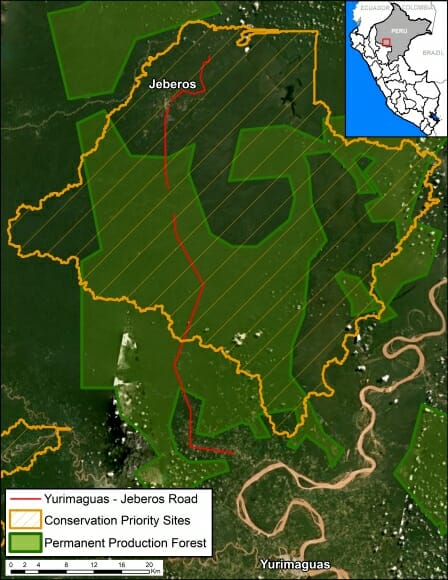
In addition, most of the route crosses “Permanent Production Forest“, a legal land classification restricted to forestry activities, not agriculture or infrastructure (Image D). The route also crosses a regional conservation priority site (Image D).

It is important to note that the Regional Government of Loreto, which is promoting and financing the project, specifically said in a press statement that the road will “encourage the expansion of the agricultural and livestock frontier in this part of the region.” That phrase can be interpreted as frankly stating that the road will cause extensive deforestation. It is a particularly troubling scenario given that Yurimaguas is already a deforestation hotspot.


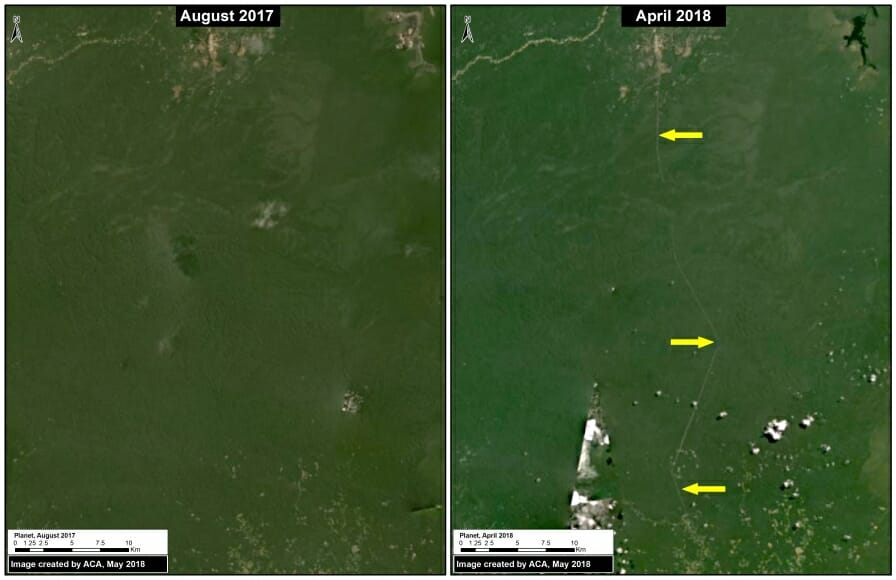
Image C shows the beginning of road construction between August 2017 (left panel) and April 2018 (right panel).

Image C. Road construction. Data: Planet.

Image D shows how the road crosses Permanent Production Forest and a regional conservation priority site.

Image D. Data: GOREL, MINAGRI, MAAP

Citation

Finer M, Mamani N (2018) New Threats to the Peruvian Amazon (Part 1: Yurimaguas-Jeberos Road). MAAP: 84.

MAAP #80: Amazon Beauty, in High-Resolution

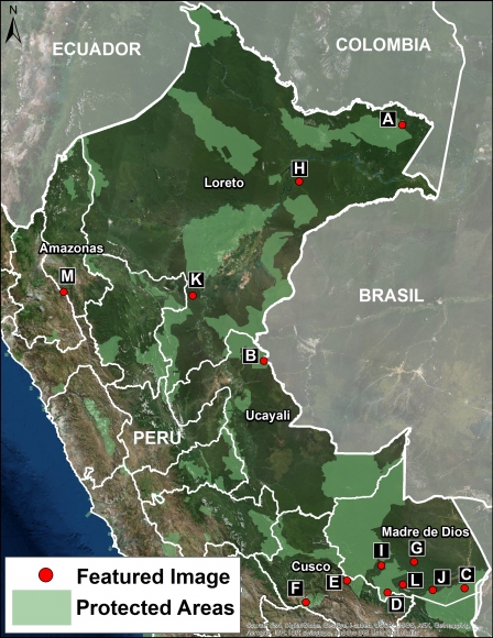
Image 80. Base Map. Data: SERNANP, MAAP

MAAP tracks the most urgent deforestation cases in the Andean Amazon, thus it can be a bit depressing. However, it is important to remember why we do it: the Amazon is spectacular.

Here, we present a series of high-resolution satellite images to show the incredible beauty of the Peruvian Amazon, and help remind us all why it is so important to protect.

All the images, obtained from DigitalGlobe, are both recent and very high resolution (less than 0.5 meters). Together, they form an art exhibition, starring the forests, rivers, and mountains of the Peruvian Amazon.

The categories of the images are: “Protected Areas” and “Threatened Areas.”

The Protected Areas include National Parks (Yaguas, Sierra del Divisor, and Manu); National Reserve (Tambopata); Communal Reserve (Amarakaeri); and Regional Conservation Area (Choquequirao).

The Threatened Areas include areas at risk due to gold mining, road construction, hydroelectric dams, and new oil palm and cacao plantations.

Click on each image to enlarge. See the base map for the location of each image (A-M).


Protected Areas

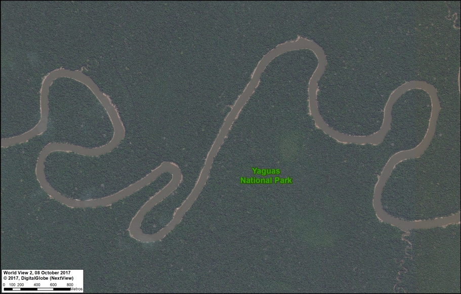
A. Yaguas National Park (Loreto)

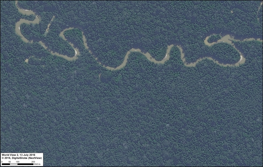
As Peru’s newest national park, created in January 2018, Yaguas National Park now protects a large (2,147,345 acres) and nearly intact stretch of the northern Peruvian Amazon. In featured Image A, we show the Yaguas River meandering through the primary forest of the eastern section of the new park.

Image 80_A. Parque Nacional Yaguas. Data: DigitalGlobe (Nextview)

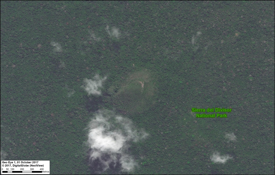
B. Sierra del Divisor National Park (Ucayali)

The second newest national park in Peru is Sierra del Divisor, created in 2015. Sierra del Divisor National Park protects more than three million acres in the remote central Peruvian Amazon, along the border with Brazil. Featured Image B shows an aerial view of the famous cone mountain in the southern part of the park.

Image B. Parque Nacional Sierra del Divisor. Data: DigitalGlobe (Nextview)

C. Tambopata National Reserve (Madre de Dios)

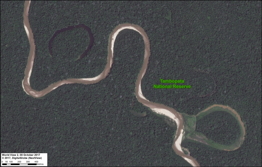
Tambopata National Reserve made headlines in 2015 due to an illegal gold mining invasion that has since been contained (MAAP #61). Fortunately, Tambopata, located in the southern Peruvian Amazon, is best known for its world-renowned biodiversity. Featured Image C shows a meandering tributary of the Tambopata River and the subsequent formation of oxbow lakes.

Image C. Reserva Nacional Tambopata. Data: DigitalGlobe (Nextview)

D. Amarakaeri Communal Reserve (Madre de Dios)

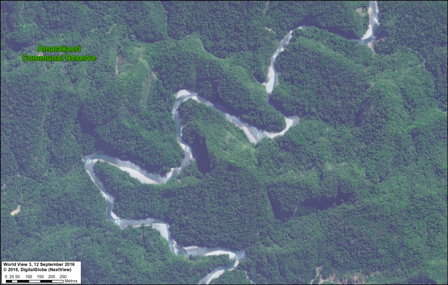
Amarakaeri Communal Reserve is an important protected area in the southern Peruvian Amazon that is jointly managed by indigenous communities (ECA Amarakaeri) and the national protected areas agency (SERNANP). Featured Image D shows a wild river winding through the rugged foothills of the southern portion of the reserve.

Image D. Reserva Comunal Amarakaeri. Data: DigitalGlobe (Nextview), SERNANP

E. Manu National Park (Cusco sector)

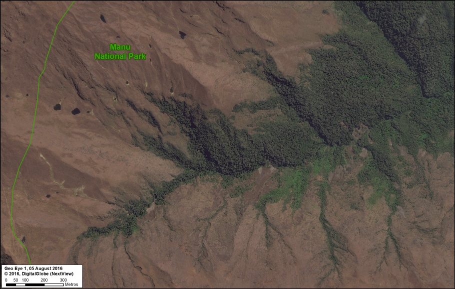
Manu is one of the most famous national parks in the world, known for its diversity of habitats in the southern Peruvian Amazon, including lowland rainforest. Featured Image E shows the other extreme, the highlands and the transition beyond treeline to an ecosystem known as puna. Interestingly, this image shown an example of the upper-most headwaters where Amazonian rivers are born.

Image E. Parque Nacional Manu. Data: DigitalGlobe (Nextview), SERNANP

F. Regional Conservation Area Choquequirao (Cusco)

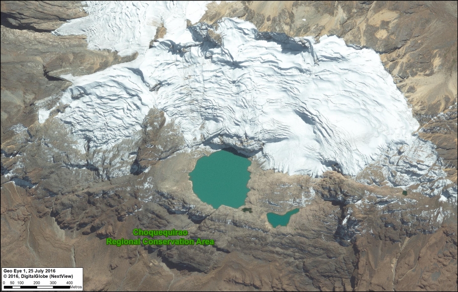
Choquequirao, one of the first examples of a regional conservation area in southern Peru, is located next to Machu Picchu. Featured Image F shows a high-elevation scene in the heart of the reserve, near the mountain peak known as Nevado Sacsarayoc.

Image F. Choquequirao. Data: DigitalGlobe (Nextview)

G. Los Amigos Conservation Concession (Madre de Dios)

It’s not technically a protected area, but a forestry concession in the southern Peruvian Amazon. In fact, Los Amigos is the first private conservation concession in the world. Featured Image G shows the meandering course of a tributary of the Los Amigos river, and the surrounding primary forest, deep in the concession.

Image G. Los Amigos. Data: DigitalGlobe (Nextview)

Threatened Areas

H. Tamshiyacu (Loreto)

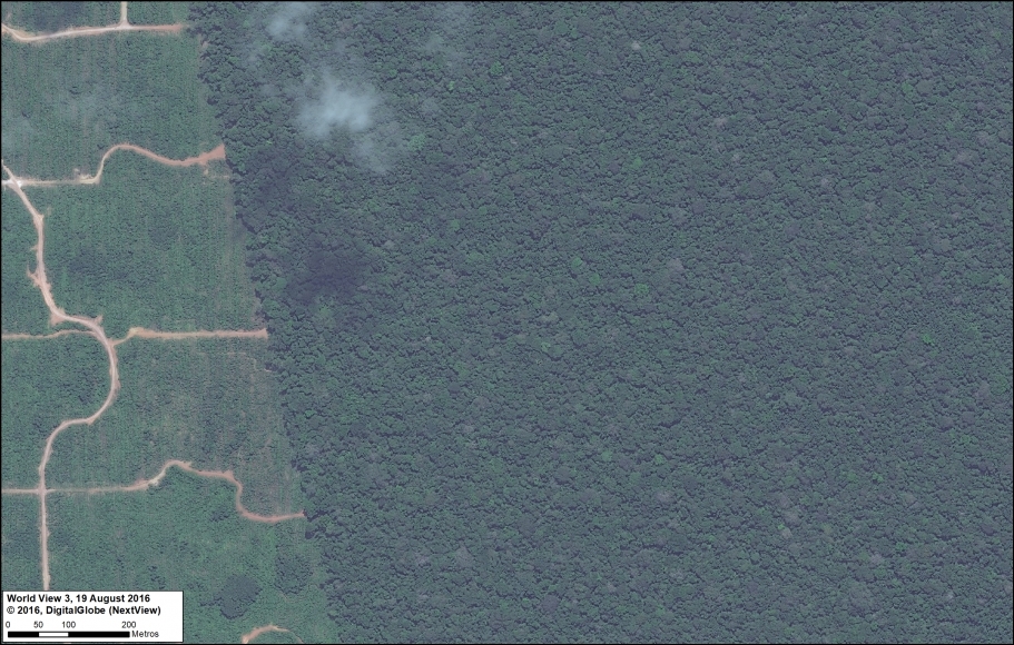
The company United Cacao clearcut 5,880 acres of primary forest near the town of Tamshiycacu in the northern Peruvian Amazon between 2013 and 2015 (MAAP #35). Featured Image H shows the abrupt transition between plantation and primary forest at the eastern end of the project area, where plans exist to expand for more large-scale cacao operations.

Image H. United Cacao. Data: DigitalGlobe (Nextview)

I. Manu-Amarakaeri Highway (Madre de Dios)

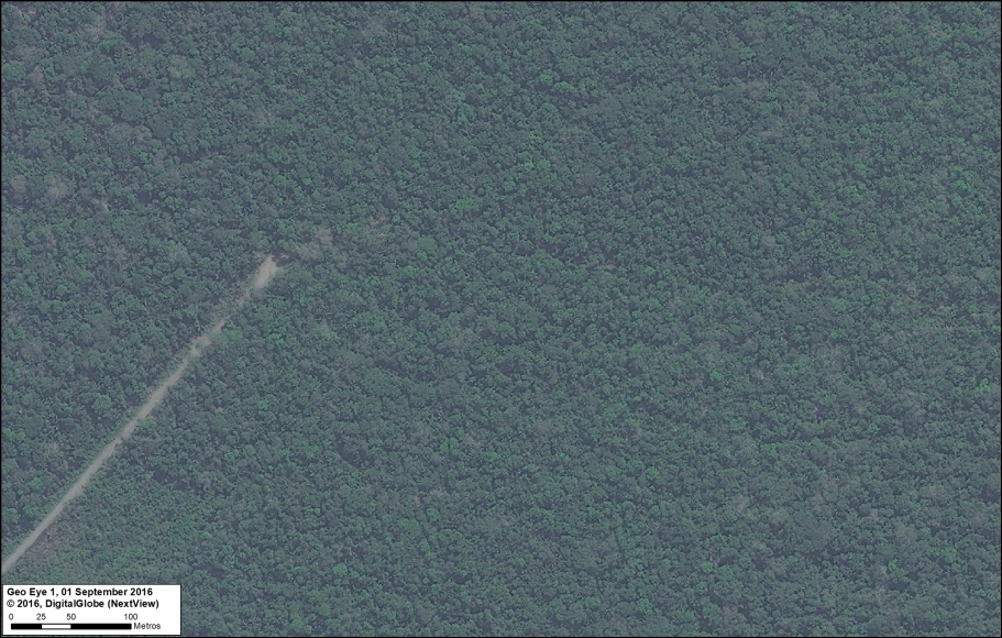
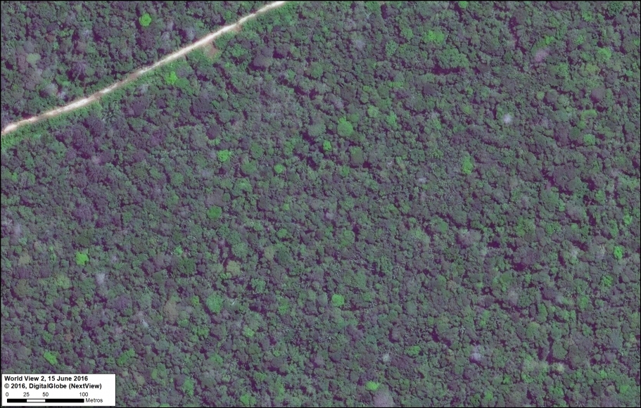
A controversial road construction project would cross the buffer zones of two important protected areas in the southern Peruvian Amazon, Amarakaeri Communal Reserve and Manu National Park. Initial construction began in 2015 before being halted by the courts, but the project continues to be a long-term threat to the area. Featured Image I shows the leading edge of the road construction, surrounded by primary forest.

Image I. Amarakaeri/Manu road. Data: DigitalGlobe (Nextview)

J. La Pampa (Madre de Dios)

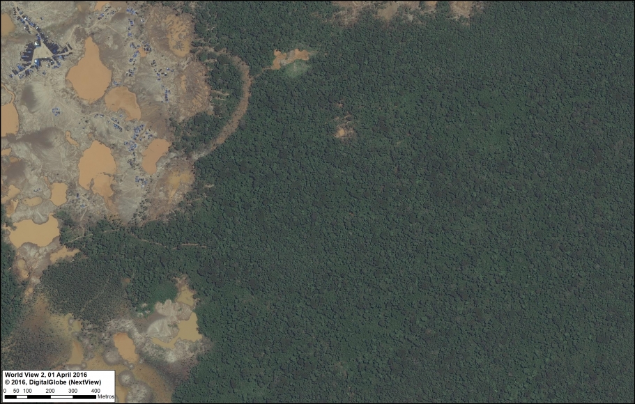
MAAP has documented the rapid expansion of gold mining deforestation in an area known as La Pampa, in the southern Peruvian Amazon (MAAP #75). Alarmingly, over 11,250 acres has been cleared since 2013. Featured Image J shows the most active mining deforestation front penetrating the primary forests to the east. Note the temporary and mobile mining camp city that has been formed near the leading edge of mining deforestation.

Image J. La Pampa. Data: DigitalGlobe (Nextview)

K. Tierra Blanca (Loreto)

The Peruvian company Grupo Romero had plans to clearcut thousands of hectares of primary forest for four large-scale oil palm plantations. There are reports that the company has abandoned the projects, in part due to pressure from civil society. Featured Image K shows the spared primary forest in one of the proposed plantations, Tierra Blanca. Note the recent construction (2014) of a logging road that still endangers the area.

Image K. Tierra Blanca. Data: DigitalGlobe (Nextview)

L. Amarakaeri Communal Reserve (Madre de Dios)

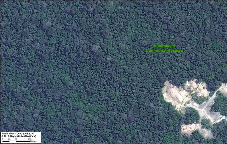
Immediately following a gold mining invasion in 2015, the co-administrators of Amarakaeri Communal Reserve (SERNANP and ECA Amarakaeri) took action against the illegal activities (see MAAP #44). Featured Image L shows the spared primary forest surrounding the abandoned invasion front at the border of the reserve.

Image L. Reserva Comunal Amarakaeri. Data: DigitalGlobe (Nextview), SERNANP

Marañon River (sector Amazonas/Cajamarca)

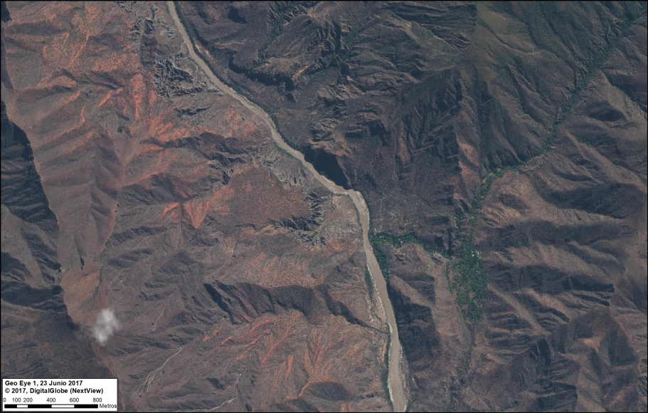
Featured Image M shows the exact location of a proposed hydroelctric dam, Chadín 2. It is one of the most advanced of the controversial 20 proposed dams along the Marañón River in the western Peruvian Amazon. It would be a large dam with the capacity to produce 600 MW of energy, and will create a flooding reservoir of over 8,000 acres. The project’s environmental impact study was approved in 2014, but construction has not yet started.

Image M. Rio Maranon. Data: DigitalGlobe (Nextview)

Coordinates

A. Yaguas: -2.72314, -70.746635
B. Sierra del Divisor: -7.962626, -73.781751
C. Tambopata: -12.93985, -69.233005
D. Amarakaeri: -13.073707, -70.966423
E. Manu: -12.816693, -71.886345
F. Choquequirao: -13.30926, -72.808164
G. Los Amigos: -12.377288, -70.380948
H. Tamshiyacu: -3.983962, -73.013498
I. Carretera Manu/Amarakaeri: -12.473042, -71.114976
J. La Pampa: -12.997284, -69.94845
K. Tierra Blanca: -6.517934, -75.366485
L. Amarakaeri: -12.88521, -70.626946
M. Chadin 2: -6.423889, -78.223333

Citation

Finer M, Mamani N (2018) Amazon Beauty, in High-Resolution. MAAP: 80.

MAAP #76: Proposed Road would cross Primary Forest along Peru-Brazil Border

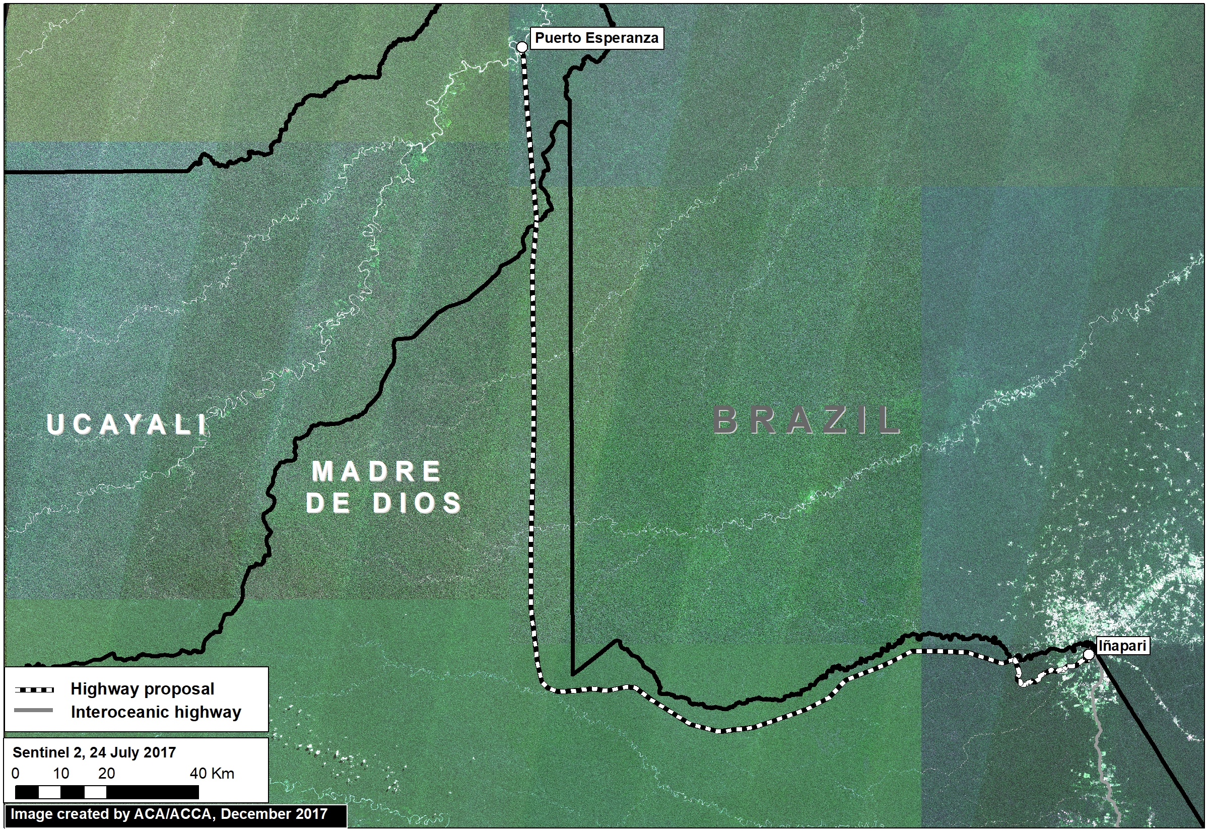
Image 76a. Base Map. Data: Mosaic of 16 images from Sentinel-2/ESA, July 2017

In December 2017, the Peruvian Congress approved a bill that declared it in the national interest to construct new roads in the border zone of Ucayali region, which shares a remote border with Brazil.

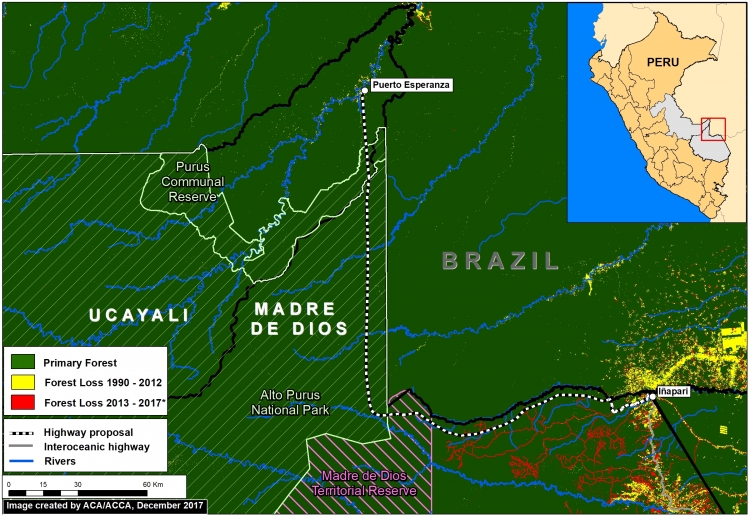
The main proposed road in this border area would cover 172 miles and connect the towns of Puerto Esperanza and Iñapari, in the Ucayali and Madre de Dios regions, respectively. Image 76a, a mosaic of satellite images from July 2017, illustrates just how remote and intact is the area surrounding the proposed road route.

Indigenous organizations and the Ministry of Culture have warned that the road would have major impacts on the indigenous peoples in voluntary isolation that are documented to inhabit parts of this remote area.

In this report, we add new information that complements the evaluation of possible impacts by calculating how much primary forest would be threatened as a result of road construction. We found that around 680,000 acres (275,00 hectares) of primary forest are at risk. Much of this area is within protected areas and a reserve for isolated indigenous groups.


Primary Forest

Image 76b. Data: GLCF/GSFC 2014, Hansen/UMD/Google/USGS/NASA, UMD/GLAD, PNCB/MINAM, UAC/ProPurús, SERNANP

We generated a primary forest layer based on existing satellite-based forest cover and forest loss data (see Methodology section for more details). We define primary forest as areas with intact forest cover dating back to the earliest available satellite-based data, 1990 in this case.

Image 76b shows the major results:

  • Virtually the entire route (172 miles; 277 km) crosses primary forest (dark green). Note the proliferation of forest roads in recent years around Iñapari (red lines).
  • The road would cross 3 critical protected areas and indigenous reserves: Madre de Dios Territorial Reserve, Alto Purús National Park, and Purús Communal Reserve.


Primary Forest at Risk

Imagen 76c. GLCF/GSFC 2014, Hansen/UMD/Google/USGS/NASA, UMD/GLAD, PNCB/MINAM, UAC/ProPurús

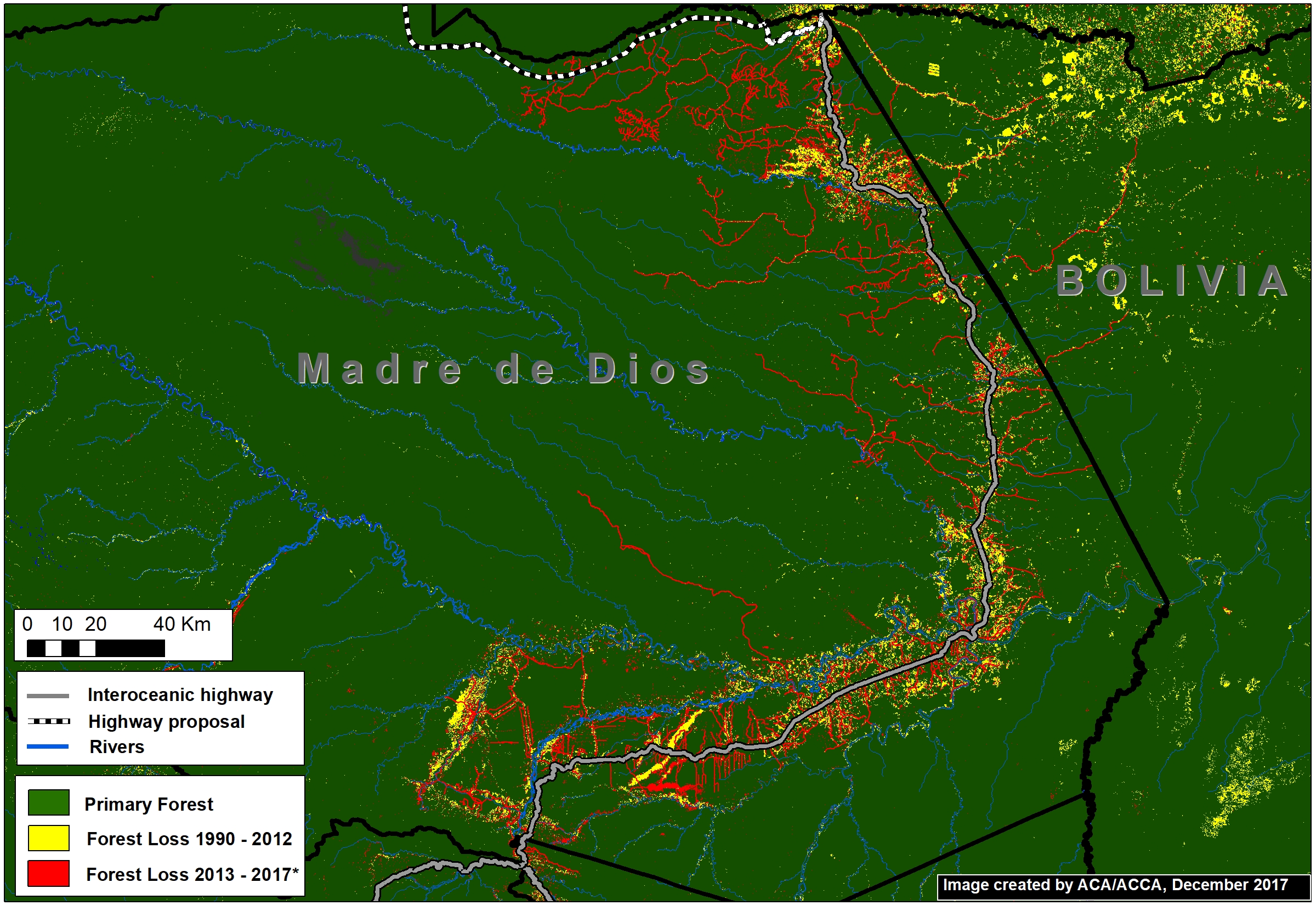
The Interoceanic Highway, the main existing road in the area, has experienced substantial deforestation within 5 km* along the length of its route (Image 76c).

Using this estimate of impact range (10 km), we calculated that at least 274,727 hectares of primary forest would be at risk if this road is constructed.

*We estimate that approximately 80% of forest loss has occurred in a 5 km radius on both sides of the Interoceanic highway.


Methodology

To generate our primary forest layer, we combined three satellite-based data sources. As baseline, we used data from the Global Land Cover Facility (2014), which identifies forest cover as of 1990. We also used this dataset to remove areas with detected forest cover change between 1990 and 2000. Next, we removed areas with detected forest loss between 2001 – 2017 identified by Hansen/UMD/Google/USGS/NASA (Hansen et al 2013) and early warning data from GLAD alerts and the National Program of Forest Conservation of the Peruvian Environment Ministry (PNBC-MINAM). As a result, combining all datasets, this methodology defines primary forest as area with intact forest from the first available satellite-based data, 1990, until 2017.

Global Land Cover Facility (GLCF) and Goddard Space Flight Center (GSFC). 2014. GLCF Forest Cover Change 2000, 2005, Global Land Cover Facility,University of Maryland, College Park.

Hansen MC et al. 2013. High-Resolution Global Maps of 21st-Century Forest Cover Change. Science 342: 850–53.

Citation

Finer M, Novoa S (2018) Proposed Road would cross Primary Forest along Peru-Brazil Border. MAAP: 76.

MAAP Interactive: Deforestation Drivers in the Andean Amazon

Since its launch in April 2015, MAAP has published over 70 reports related to deforestation (and natural forest loss) in the Andean Amazon. We have thus far focused on Peru, with several reports in Colombia and Brazil as well.

These reports are meant to be case studies of the most important and urgent deforestation events. We often use forest loss alerts (known as GLAD) to guide us, and satellite imagery (from Planet and DigitalGlobe) to identify the deforestation driver.

Here we present an interactive map highlighting the drivers identified in all published MAAP reports. These drivers include gold mining, agriculture (e.g. oil palm and cacao), cattle pasture, roads, and dams (see icon legend below map). We also include natural causes such as floods and blowdowns (fire included under agriculture since most human caused). Furthermore, we highlight deforestation events within protected areas. Note that you can filter by driver by checking boxes of interest.

We hope the result is one of the most detailed and up-todate resources on patterns and drivers of deforestation in the Andean Amazon. Over the coming year we will continue to focus on Peru and Colombia, and begin to include Ecuador and Bolivia as well.

To view the interactive map, please visit:

MAAP Interactive: Deforestation Drivers in the Andean Amazon
https://www.maaproject.org/interactive/

For more information on patterns and drivers of deforestation in the Peruvian Amazon, see our latest Synthesis report 

MAAP SYNTHESIS #2: PATTERNS AND DRIVERS OF DEFORESTATION IN THE PERUVIAN AMAZON

We present our second synthesis report, building off our first report published in September 2015. This synthesis is largely based on the 50 MAAP reports published between April 2015 and November 2016. The objective is to synthesize all the information to date regarding deforestation trends, patterns and drivers in the Peruvian Amazon.

MAAP methodology includes 4 major components: Forest loss detection, Prioritize big data, Identify deforestation drivers, and Publish user-friendly reports. See Methodology section below for more details.

Our major findings include:

  • Trends. During the 15 years between 2001 and 2015, around 4,448,000 acres (1,800,000 hectares) of Peruvian Amazon forest has been cleared, with a steadily increasing trend. 2014 had the highest annual forest loss on record (438,775 acres), followed by a slight decrease  in 2015. The preliminary estimate for 2016 indicates that forest loss remains relatively high. The vast majority (80%) of forest loss events in the Peruvian Amazon are small-scale (<5 hectares), while large-scale events (> 50 hectares) pose a latent threat due to new agro-industrial projects.
  • Hotspots. We have identified at least 8 major deforestation hotspots. The most intense hotspots are located in the central Amazon (Huánuco and Ucayali). Other important hotspots are located in Madre de Dios and San Martin. Two protected areas (Tambopata National Reserve and El Sira Communal Reserve) are threatened by these hotspots.
  • Drivers. We present an initial deforestation drivers map for the Peruvian Amazon. Analyzing high-resolution satellite imagery, we have documented six major drivers of deforestation and degradation: small/medium-scale agriculture, large-scale agriculture, cattle pasture, gold mining, illegal coca cultivation, and roads. Small-scale agriculture and cattle pasture are likely the most dominant drivers overall. Gold mining is a major driver in southern Peru. Large-scale agriculture and major new roads are latent threats. Logging roads are likely a major source of forest degradation in central Peru.

Deforestation Trends

Image 1 shows forest loss trends in the Peruvian Amazon from 2001 to 2015, including a breakdown of the size of the forest loss events. This includes the official data from the Peruvian Environment Ministry, except for 2016, which is a preliminary estimate based on GLAD forest loss alerts.
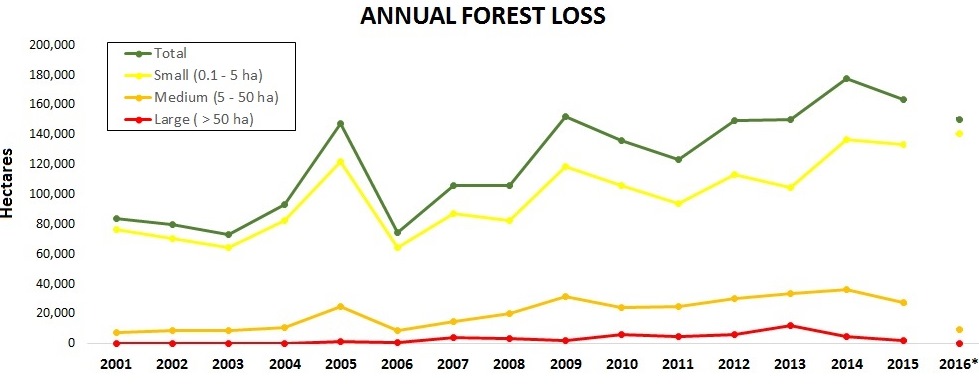
Image 1. Data: PNCB/MINAM, UMD/GLAD. *Estimate based on GLAD alerts.

During the 15 years between 2001 and 2015, around 4,448,000 acres (1,800,000 hectares) of Peruvian Amazon forest has been cleared (see green line). This represents a loss of approximately 2.5% of the existing forest as of 2001.There have been peaks in 2005, 2009, and 2014, with an overall increasing trend. In fact, 2014 had the highest annual forest loss on record (386,626 acres). Forest loss decreased in 2015 (386,732 acres), but is still the second highest recorded. The preliminary estimate for 2016 indicates that forest loss continues to be relatively high.

It is important to note that the data include natural forest loss events (such as storms, landslides, and river meanders), but overall serves as our best proxy for anthropogenic deforestation. The non-anthropogenic forest loss is estimated to be approximately 3.5% of the total.1

The vast majority (81%) of forest loss events in the Peruvian Amazon are small-scale (<5 hectares, equivalent of 12 acres), see the yellow line. Around 16% of the forest loss events are medium-scale (5-50 hectares, equivalent of 12-124 acres), see the orange line. Large-scale (>50 hectares, equivalent of 124 acres) forest loss events, often associated with industrial agriculture, pose a latent threat. Although the average is only 2%, large-scale forest loss rapidly spiked to 8% in 2013 due to activities linked with a pair of new oil palm and cacao plantations. See MAAP #32 for more details on the patterns of sizes of deforestation events.

Deforestation Patterns

Image 2 shows the major deforestation hotspots in 2012-14 (left panel) relative to 2015-16 (right panel), based on a kernel density analysis.We have identified at least 8 major deforestation hotspots, labeled as Hotspots A-H.
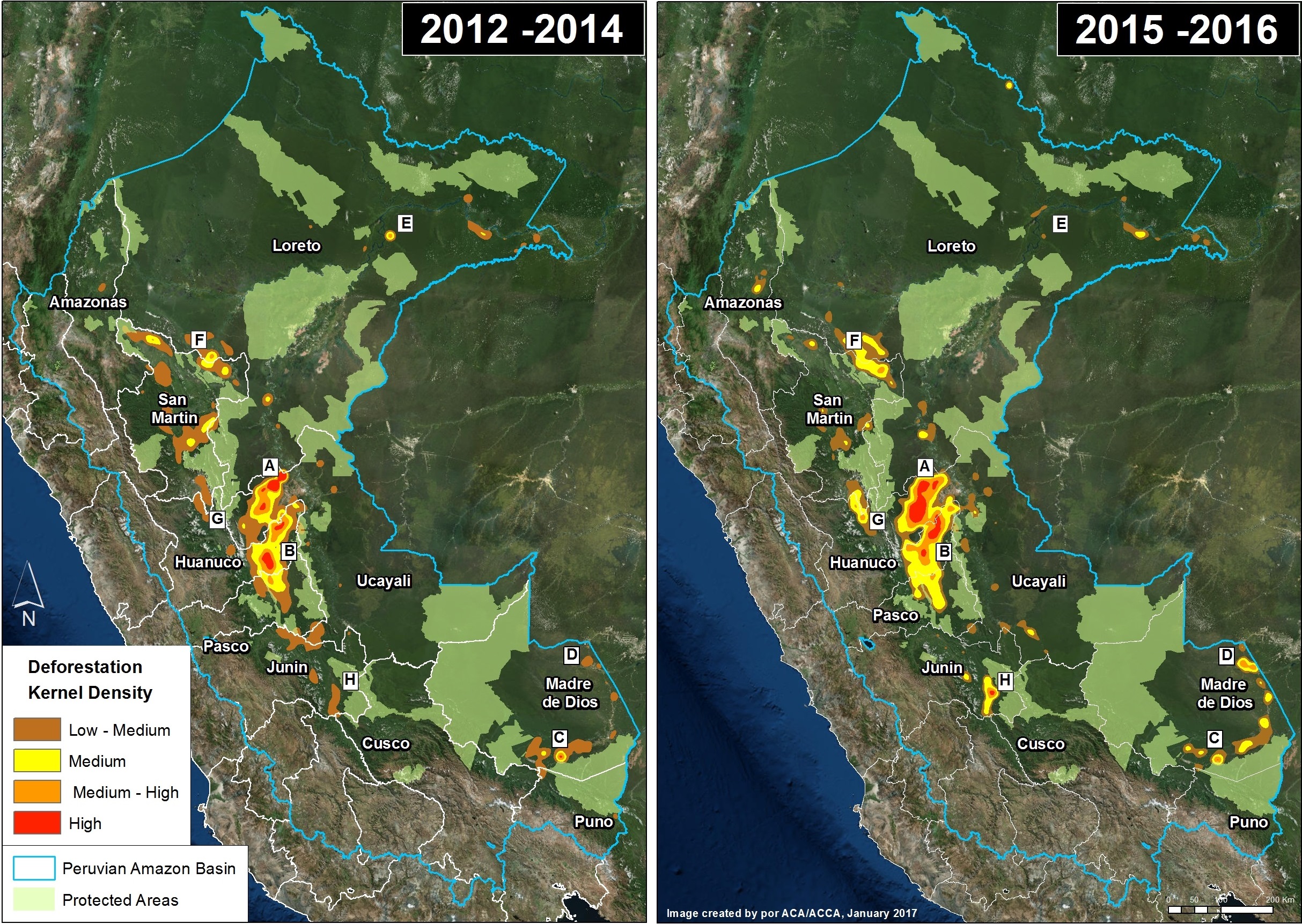
Image 2. Data: PNCB/MINAM, GLAD/UMD. Click to enlarge.

The most intense hotspots, A and B, are located in the central Amazon. Hotspot A, in northwest Ucayali, was dominated by two large-scale oil palm projects in 2012-14, but then shifted a bit to the west in 2015-16, where it was dominated by cattle pasture and small-scale oil palm. Hotspot B, in eastern Huánuco, is dominated by cattle pasture (MAAP #26).

Hotspots C and D are in the Madre de Dios region in the southern Amazon. Hotspot C indicates the primary illegal gold mining front in recent years (MAAP #50). Hotspot D highlights the emerging deforestation zone along the Interoceanic Highway, particularly around the town of Iberia (MAAP #28).

Hotspots E-H are agriculture related. Hotspot E indicates the rapid deforestation for a large-scale cacao plantation in 2013-14, with a sharp decrease in forest loss 2015-16 (MAAP #35). Hotspot F indicates the expanding deforestation around two large-scale oil palm plantation (MAAP #41). Hotspot G indicates the intensifying deforestation for small-scale oil palm plantations (MAAP #48).

Hotspot H indicates an area impacted by intense wildfires in 2016.

Protected Areas, in general, are effective barriers against deforestation (MAAP #11). However, several protected areas are currently threatened, most notably Tambopata National Reserve (Hotspot C; MAAP #46). and El Sira Communal Reserve (Hotspot B; MAAP #45).

Deforestation Drivers
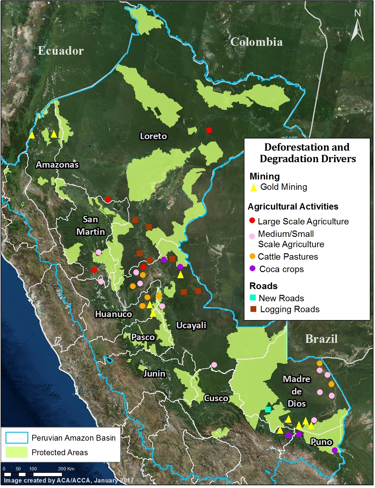
Image 3. Data: MAAP, SERNANP. Click to enlarge.

Surprisingly, there is a striking lack of precise information about the actual drivers of deforestation in the Peruvian Amazon. According to an important paper published in 2016, much of the existing information is vague and outdated, and is based solely on a general analysis of the size of deforestation events.3  

As noted above, one of the major advances of MAAP has been using high-resolution imagery to better identify deforestation drivers.

Image 3 shows the major deforestation drivers identified thus far by our analysis. As far as we know, it represents the first spatially explicit deforestation drivers map for the Peruvian Amazon.

To date, we have documented six major direct drivers of deforestation and degradation in the Peruvian Amazon: small/medium-scale agriculture, large-scale agriculture, cattle pasture, gold mining, illegal coca cultivation, and roads.

At the moment, we do not consider the hydrocarbon (oil and gas) and hydroelectric dam sectors as major drivers in Peru, but this could change in the future if proposed projects move forward.

We describe these major drivers of deforestation and degradation in greater detail below.

Small/Medium-scale Agriculture

The literature emphasizes that small-scale agriculture is the leading cause of deforestation in the Peruvian Amazon.However, there is little actual empirical evidence demonstrating that this is true.3 The raw deforestation data is dominated by small-scale clearings that are most likely for agriculture or cattle pasture. Thus, it is likely that small-scale agriculture is a major driver, but a definitive study utilizing high-resolution imagery and/or extensive field work is still needed to verify the assumption.

In several key case studies, we have shown specific examples of small-scale agriculture being a deforestation driver. For example, using a combination of high-resolution imagery, photos from the field, and local sources, we have determined that:

  • Oil Palm, in the form of small and medium-scale plantations, is one of the main drivers within deforestation Hotspot B (Ucayali; MAAP #26), Hotspot G (northern Huánuco; MAAP #48), and Hotspot F (Loreto-San Martin;MAAP #16). This was also shown for Ucayali in a recent peer-reviewed study.4 See below for information about large-scale oil palm.
  • Cacao is causing rapid deforestation along the Las Piedras River in eastern Madre de Dios (MAAP #23, MAAP #40). See below for information about large-scale cacao.
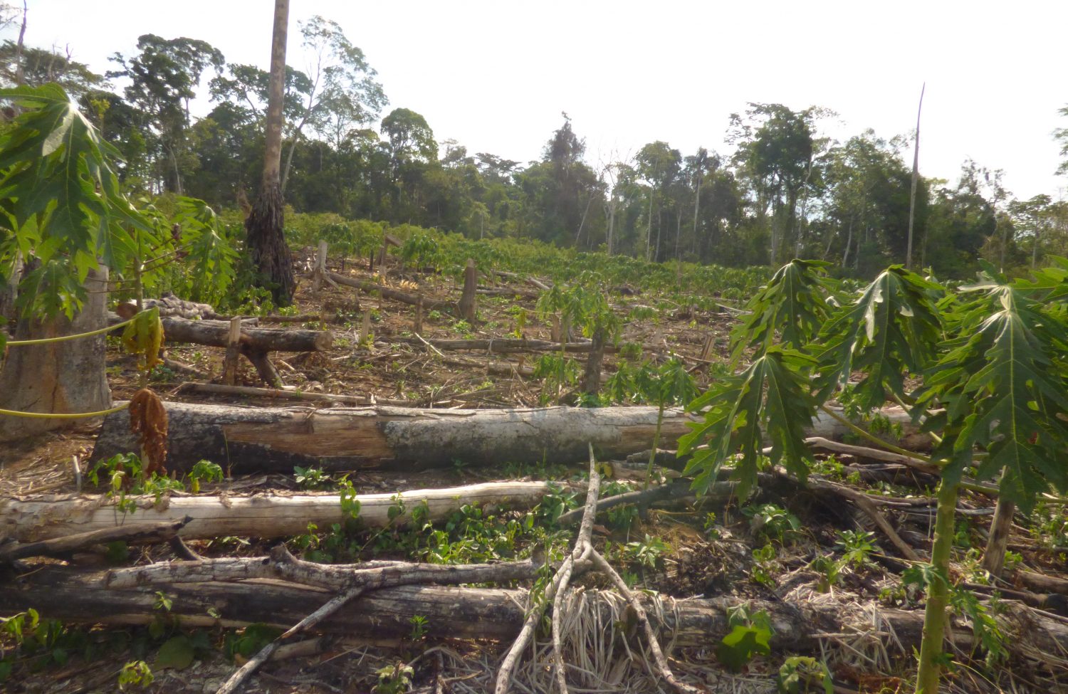
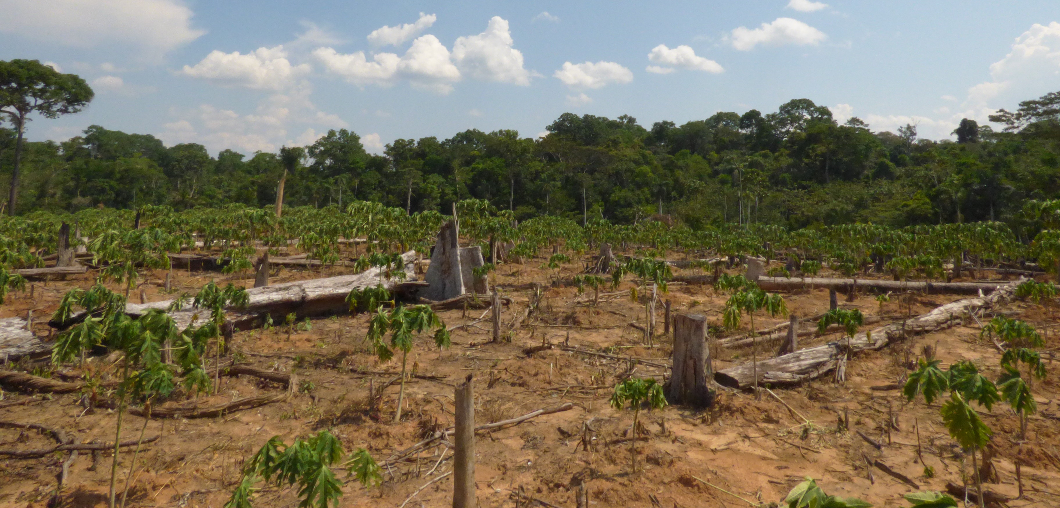
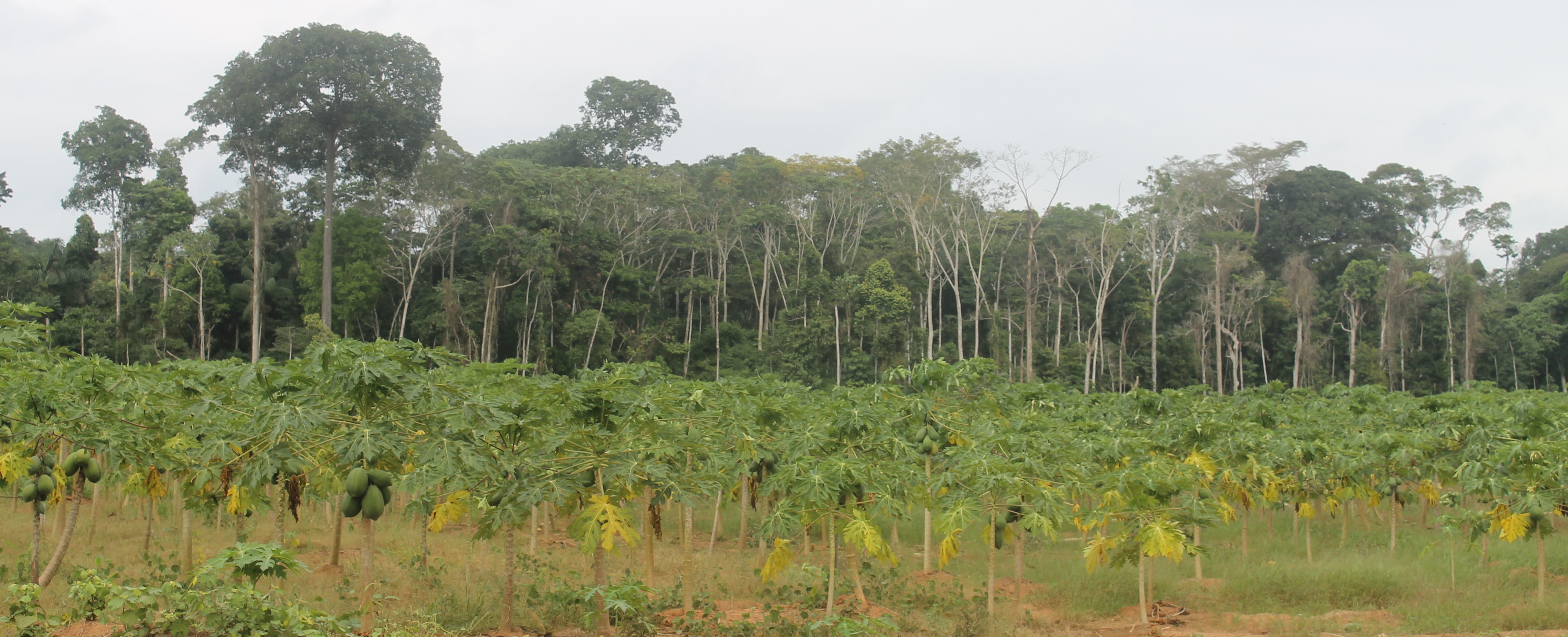
  • Papaya is an important new driver in Hotspot D, along the Interoceanic Higway in eastern Madre de Dios (MAAP #42).
  • Corn and rice plantations may also be an important driver in Hotspot D in eastern Madre de Dios (MAAP #28).

Large-scale Agriculture

Large-scale, agro-industrial deforestation remains a latent threat in Peru, particularly in the central and northern Amazon regions. This issue was put on high alert in 2013, with two cases of large-scale deforestation for oil palm and cacao plantations, respectively.

In the oil palm case, two companies that are part of the Melka group,5 cleared nearly 29,650 acres in Hotspot A in Ucayali between 2012 and 2015 (MAAP #4, MAAP #41). In the cacao case, another company in the Melka group (United Cacao) cleared 5,880 acres in Hotspot E in Loreto between 2013 and 2015 (MAAP #9, MAAP #13, MAAP #27, MAAP #35). Dennis Melka has explicitly stated that his goal is to bring the agro-industrial production model common in Southeast Asia to the Peruvian Amazon.6

Prior to these cases, large-scale agricultural deforestation occurred between 2007 and 2011, when oil palm companies owned by Grupo Palmas7 cleared nearly 17,300 acres for plantations in Hotspot H along the Loreto-San Martin border (MAAP #16). Importantly, we documented the additional deforestation of 24,215 acres for oil palm plantations surrounding the Grupo Palmas projects (MAAP #16).

In contrast, large-scale agricultural deforestation was minimal in 2015 and 2016. However, as noted above, it remains a latent threat. Both United Cacao and Grupo Palmas have expansion plans that would clear over 49,420 acres of primary forest in Loreto.8

Cattle Pasture

Using an archive of satellite imagery, we documented that deforestation for cattle pasture is a major issue in the central Peruvian Amazon. Immediately following a deforestation event, the scene of hundreds or thousands of recently cut trees often looks the same whether the cause is agriculture or cattle pasture. However, by using an archive of imagery and studying deforestation events from previous years, one can more easily determine the drivers of the forest loss. For example, after a year or two, agriculture and cattle pasture appear very differently in the imagery and thus it is possible to distinguish these two drivers.

Using this technique, we determined that cattle pasture is a major driver in Hotspots A and B, in the central Peruvian Amazon (MAAP #26, MAAP #37).

We also used this technique to determine that much of the deforestation in the northern section of El Sira Communal Reserve is due to cattle pasture (MAAP #45).

Maintenance of cattle pasture, and small-scale agriculture, are likely important factors behind the escaped fires that degrade the Amazon during intense dry seasons (MAAP #45, MAAP #47).

Gold Mining

Gold mining is one of the major drivers of deforestation in the southern Peruvian Amazon (Hotspot C). An important study found that gold mining cleared around 123,550 acres up through 2012.9 We built off this work, and by analyzing hundreds of high resolution imageres, found that gold mining caused the loss of an additional 30,890 acres between 2013 and 2016 (MAAP #50). Thus, gold mining is thus far responsible for the total loss of around 154,440 acres in southern Peru. Much of the most recent deforestation is illegal due to its occurrence in protected areas and buffer zones strictly off-limits to mining activities.

Most notably, we have closely tracked the illegal gold mining invasion of Tambopata National Reserve, an important protected area in the Madre de Dios region with renowned biodiversity and ecotourism. The initial invasion occurred in November 2015 (MAAP #21), and has steadily expanded to over 1,110 acres (MAAP #24, MAAP #30, MAAP #46). As part of this invasion, miners have modified the natural course of the Malinowski River, which forms the natural northern border of the reserve (MAAP #33). In addition, illegal gold mining deforestation continues to expand within the reserve’s buffer zone, particularly in an area known as La Pampa (MAAP #12, MAAP #31).

Further upstream, illegal gold mining is also expanding on the upper Malinowski River, within the buffer zone of Bahuaja Sonene National Park (MAAP #19, MAAP #43).

In contrast to the escalating situation in Tambopata, we also documented that gold mining deforestation has been contained in the nearby Amarakaeri Communal Reserve, an important protected area that is co-managed by indigenous communities and Peru’s national protected areas agency. Following an initial invasion of 27 acres in 2014 and early 2015, satellite imagery shows that management efforts have prevented any subsequent expansion within the protected area (MAAP #6, MAAP #44).

In addition to the above cases in Madre de Dios, gold mining deforestation is also increasingly an issue in the adjacent regions of Cusco and Puno (MAAP #14).

There are several small, but potentially emerging, gold mining frontiers in the central and northern Peruvian Amazon (MAAP #49). The Peruvian government has been working to contain the illegal gold mining in the El Sira Communal Reserve (MAAP #45). Further north in Amazonas region, there is gold mining deforestation along the Rio Santiago (MAAP #36, MAAP #49), and in the remote Condor mountain range along the border with Ecuador (MAAP #49).

Roads

Roads are a well-documented driver of deforestation in the Amazon, particularly due to their ability to facilitate human access to previously remote areas.10 Roads often serve as an indirect driver, as most of the deforestation directly associated with agriculture, cattle pasture, and gold mining is likely greatly facilitated by proximity to roads. We documented the start of a controversial road construction project that would cut through the buffer zones of two important protected areas, Amarakaeri Communal Reserve and Manu National Park (MAAP #29).

Logging Roads

In relation to general roads described above, we distinguish access roads that are constructed to gain entry to a particular project. The most notable type of access roads in Peru are logging roads, which are likely a leading cause of forest degradation as they facilitate selective logging of valuable timber species in remote areas.

One of the major recent advances in forest monitoring is the ability to quickly identify the construction of new logging roads. The unique linear pattern of these roads appears quite clearly in Landsat-based tree cover loss alerts such as GLAD and CLASlite. This advance is important because it is difficult to detect illegal logging in satellite imagery because loggers in the Amazon often selectively cut high value species and do not produce large clearings. But now, although it remains difficult to detect the actual selective logging, we can detect the roads that indicate that selective logging is taking place in that area.

In a series of articles, we highlighted the recent expansion of logging roads, including the construction of 1,134 km between 2013 and 2015 in the central Peruvian Amazon (MAAP #3, MAAP #18). Approximately one-third of these roads were within the buffer zones of Cordillera Azul and Sierra del Divisor National Parks (MAAP #15).

We documented the construction of an additional 83 km of logging roads during 2016,  (MAAP #40, MAAP #43) including deeper into the buffer zone of Cordillera Azul National Park.

Another major finding is the rapid construction of the logging roads. In several cases, we documented the construction rate of nearly five kilometers per week (MAAP #18, MAAP #40, MAAP #43).

Determining the legality of these logging roads is complex, partly because of the numerous national and local government agencies involved in the authorization process. Many of these roads are near logging concessions and native communities, whom may have obtained the rights for logging from the relevant forestry authority (in many cases, the regional government).

Coca

According to a recent United Nations report, the Peruvian land area under coca cultivation in 2015 (99,580 acres) was the lowest on record (since 2001) and part of a declining trend since 2011 (154,440 acres).11 There are 13 major coca growing zones in Peru, but it appears that only a few of them are actively causing new deforestation. Most important are two coca zonas in the region of Puno that are causing deforestation within and around Bahuaja Sonene National Park (MAAP #10, MAAP #14). Several coca zones in the regions of Cusco and Loreto may also be causing some new deforestation.

Hydroelectric Dams

Although there is a large portfolio of potential new hydroelectric dam projects in the Peruvian Amazon,12 many of not advanced to implementation phase. Thus, forest loss due to hydroelectric dams is not currently a major issue, but this could quickly change in the future if these projects are revived. For example, in adjacent western Brazil, we documented the forest loss of 89,205 acres associated with the flooding caused by two dams on the upper Madeira River (MAAP #34).

Hydrocarbon (Oil & Gas)

During the course of our monitoring, we have not yet detected major deforestation events linked to hydrocarbon-related activities. As with dams, this could change in the future if oil and gas prices rise and numerous projects in remote corners of the Amazon move forward.

Methodology

MAAP methodology has 4 major components:

  1. Forest Loss Detection. MAAP reports rely heavily on early-warning tree cover loss alerts to help us identify where new deforestation is happening. Currently, our primary tool is GLAD alerts, which are developed by the University of Maryland and Google,13 and presented by WRI’s Global Forest Watch and Peru’s GeoBosques. These alerts, launched in Peru in early 2016, are based on 30-meter resolution Landsat satellite images and updated weekly. We also occasionally incorporate CLASlite, forest loss detection software based on Landsat (and now Sentinel-2) developed by the Carnegie Institution for Science, and the moderate resolution (250 meters) Terra-i alerts. We are also experimenting with Sentinel-1 radar data (freely available from the European Space Agency), which has the advantage of piercing through cloud cover in order to continue monitoring despite persistent cloudy conditions
  2. Prioritize Big Data. The early warning systems noted above yield thousands of alerts, thus a procedure to prioritize the raw data is needed. We employ numerous prioritization methods, such as creation of hotspot maps (see below), focus on key areas (such as protected areas, indigenous territories, and forestry concessions), and identification of striking patterns (such as linear features or large-scale clearings).
  1. Identify Deforestation Drivers. Once priority areas are identified, the next challenge is to understand the cause of the forest loss. Indeed, one of the major advances of MAAP over the past year has been using high-resolution satellite imagery to identify key deforestation drivers. Our ability to identify these deforestation drivers has been greatly enhanced thanks to access to high-resolution satellite imagery provided by Planet 14
    (via their Ambassador Program) and Digital Globe (via the NextView Program, courtesy of an agreement with USAID). We also occasionally purchase imagery from Airbus(viaApollo Mapping).
  2. Publish User-Friendly Reports. The final step is to publish technical, but accessible, articles highlighting novel and important findings on the MAAP web portal. These articles feature concise text and easy-to-understand graphics aimed at a wide audience, including policy makers, civil society, researchers, students, journalists, and the public at large. During preparation of these articles, we consult with Peruvian civil society and relevant government agencies in order to improve the quality of the information.

Endnotes

MINAM-Peru (2016) Estrategia Nacional sobre Bosques y Cambio Climático.

Methodology: Kernel Density tool from Spatial Analyst Tool Box of ArcGis. The 2016 data is based on GLAD alerts, while the 2012-15 data is based on official annual forest loss data

Ravikumar et al (2016) Is small-scale agriculture really the main driver of deforestation in the Peruvian Amazon? Moving beyond the prevailing narrative. Conserv. Lett. doi:10.1111/conl.12264

4 Gutiérrez-Vélez VH et al (2011). High-yield oil palm expansion spares land at the expense of forests in the Peruvian Amazon. Environ. Res. Lett., 6, 044029.

Environmental Investigation Agency EIA (2015) Deforestation by Definition.

NG J (2015) United Cacao replicates Southeast Asia’splantation model in Peru, says CEO Melka. The Edge Singapore, July 13, 2015.

Palmas del Shanusi & Palmas del Oriente; http://www.palmas.com.pe/palmas/el-grupo/empresas

Hill D (2015) Palm oil firms in Peru plan to clear 23,000 hectares of primary forest. The Guardian, March 7, 2015.

Asner GP, Llactayo W, Tupayachi R,  Ráez Luna E (2013) Elevated rates of gold mining in the Amazon revealed through high-resolution monitoring. PNAS 46: 18454. They reported 46,417 hectares confirmed and 3,268 hectares suspected (49,865 ha total).

10 Laurance et al (2014) A global strategy for road building. Nature 513:229; Barber et al (2014) Roads, deforestation, and the mitigating effect of protected areas in the Amazon.  Biol Cons 177:203.

11 UNODC/DEVIDA (2016) Perú – Monitoreo de Cultivos de Coca 2015.

12 Finer M, Jenkins CN (2012) Proliferation of Hydroelectric Dams in the Andean Amazon and Implications for Andes-Amazon Connectivity. PLoS ONE 7(4): e35126.

13 Hansen MC et al (2016) Humid tropical forest disturbance alerts using Landsat data. Environ Res Lett 11: 034008.

14 Planet Team (2017). Planet Application Program Interface: In Space for Life on Earth. San Francisco, CA. https://api.planet.com

Citation

Finer M, Novoa S (2017) Patterns and Drivers of Deforestation in the Peruvian Amazon. MAAP: Synthesis #2.

MAAP #42: Papaya – New Deforestation Driver in Peruvian Amazon

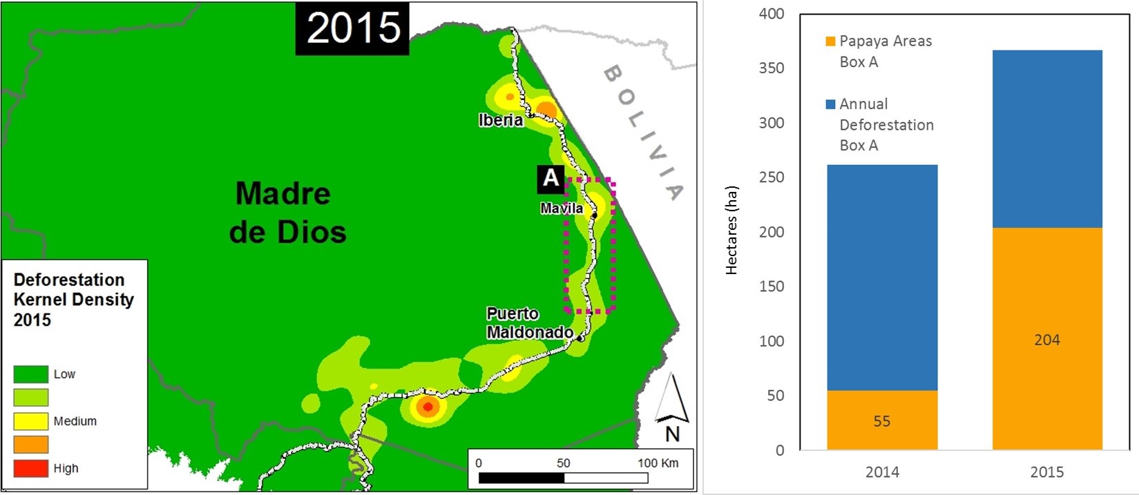
In the previous MAAP #26, we published a preliminary map of Deforestation Hotspots in the Peruvian Amazon for 2015. Subsequently in 2016, we have been compiling information to improve understanding on the potential causes (drivers) of deforestation in the identified hotspots. In this article, we focus on a medium-intensity hotspot located along the newly paved Interoceanic Highway in the eastern part of the Madre de Dios region (see Inset A in Image 42a).

Image 42a. Data. UMD/GLAD, MTC, MAAP

The analysis in this article is based on field work carried out by the Peruvian Ministry of Environment, in collaboration with Terra-i. This team has verified the presence of papaya plantations in the area indicated by Inset A and shared their photos and coordinates with MAAP to allow us to search for and analyze relevant satellite imagery.

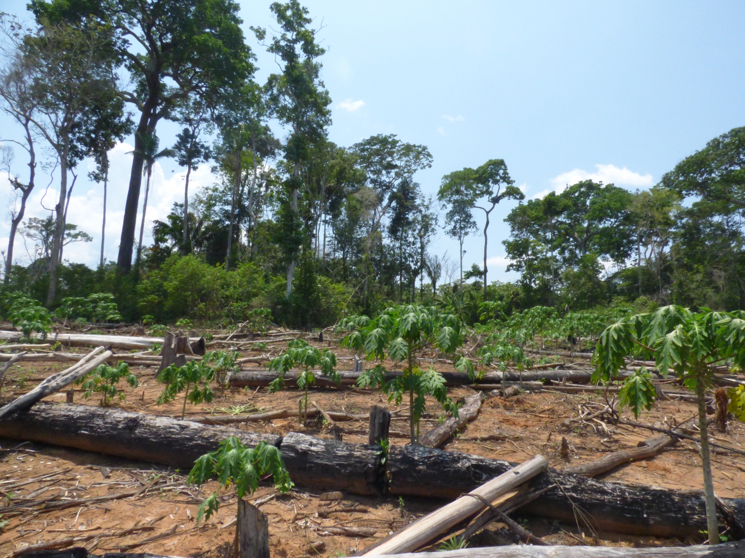
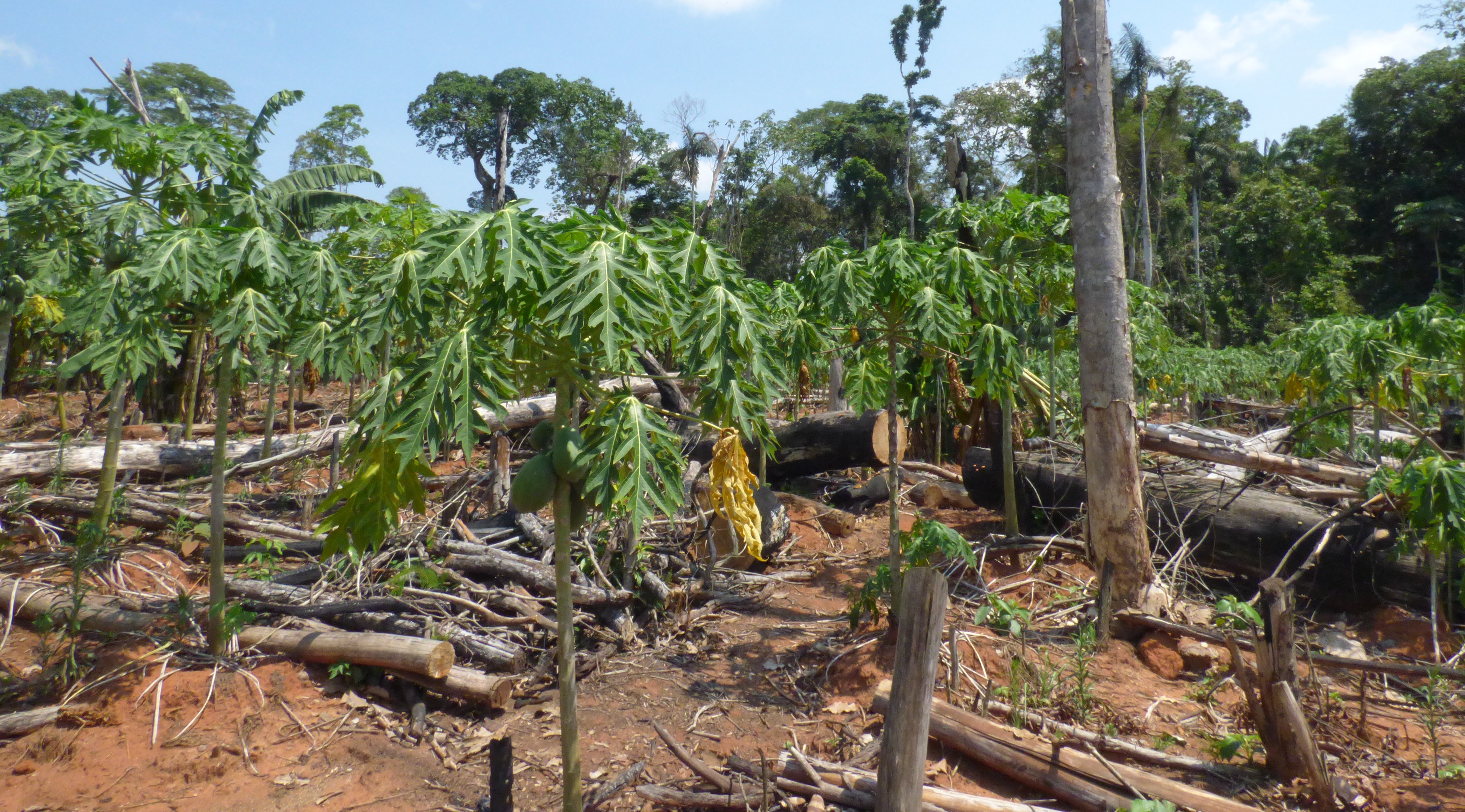
Synthesizing all of the available information, we found that the establishment of papaya plantations was an important deforestation driver in the area in 2015. Within the focal area (Inset A), we estimate the deforestation of 204 hectares (504 acres) for papaya plantations in 2015, a major increase relative to 2014 (see bar graph in Image 42a).

All of the papaya deforestation is small (< 5 hectares) or medium (5-50 hectares) scale. According to the analysis presented in MAAP #32, these two scales represented 99% of the deforestation events in Peru in 2015. Approximately 90% of the observed deforestation is within areas zoned for agricultural activity. Therefore, the legality of the deforestation in not known (i.e. if all the required permits were obtained).

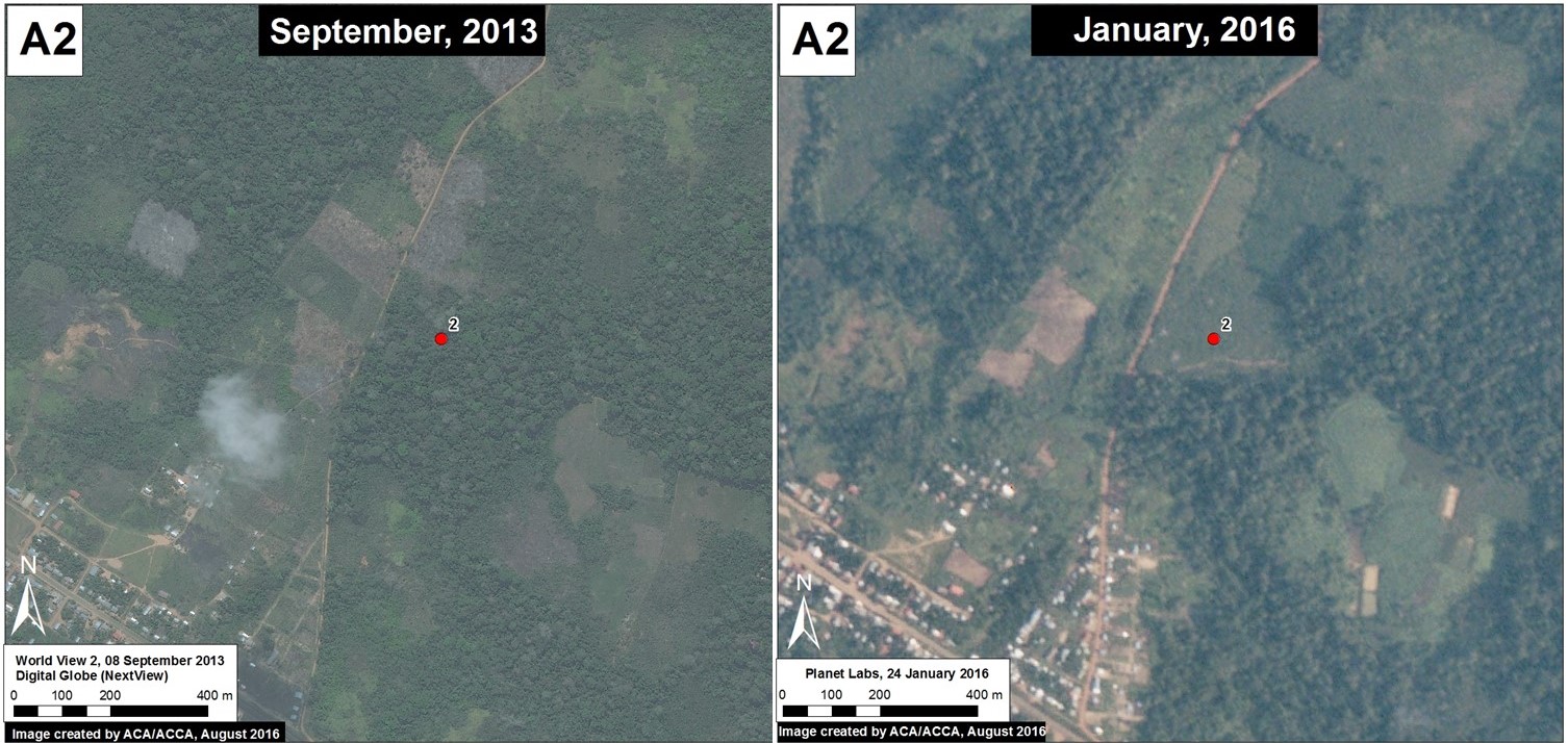
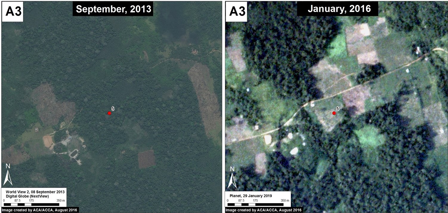
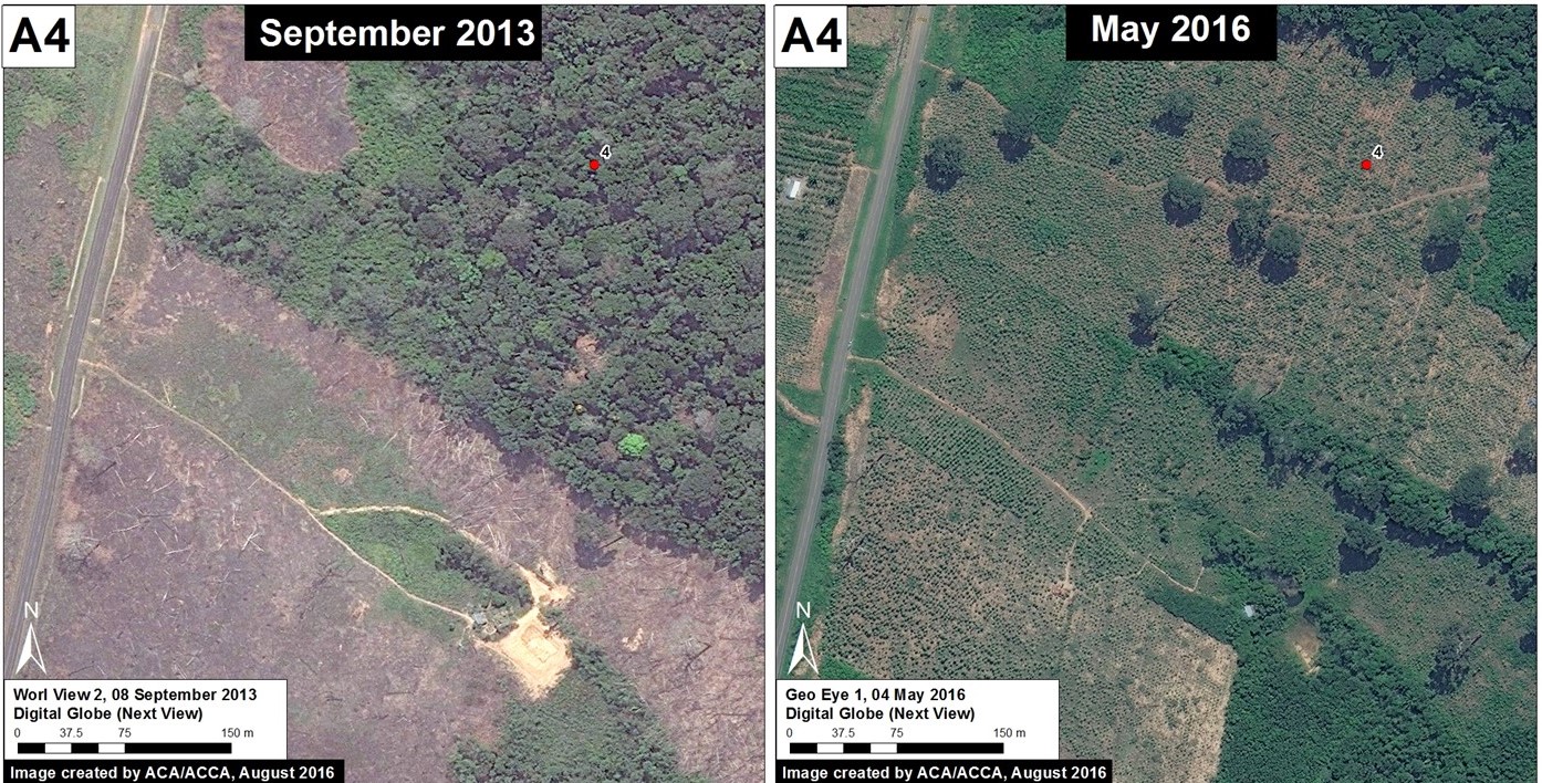
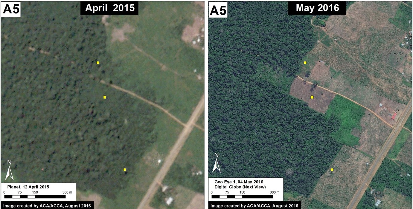
Below, we show satellite images and field photos of 5 examples of the recent deforestation caused by papaya cultivation.

Example #1

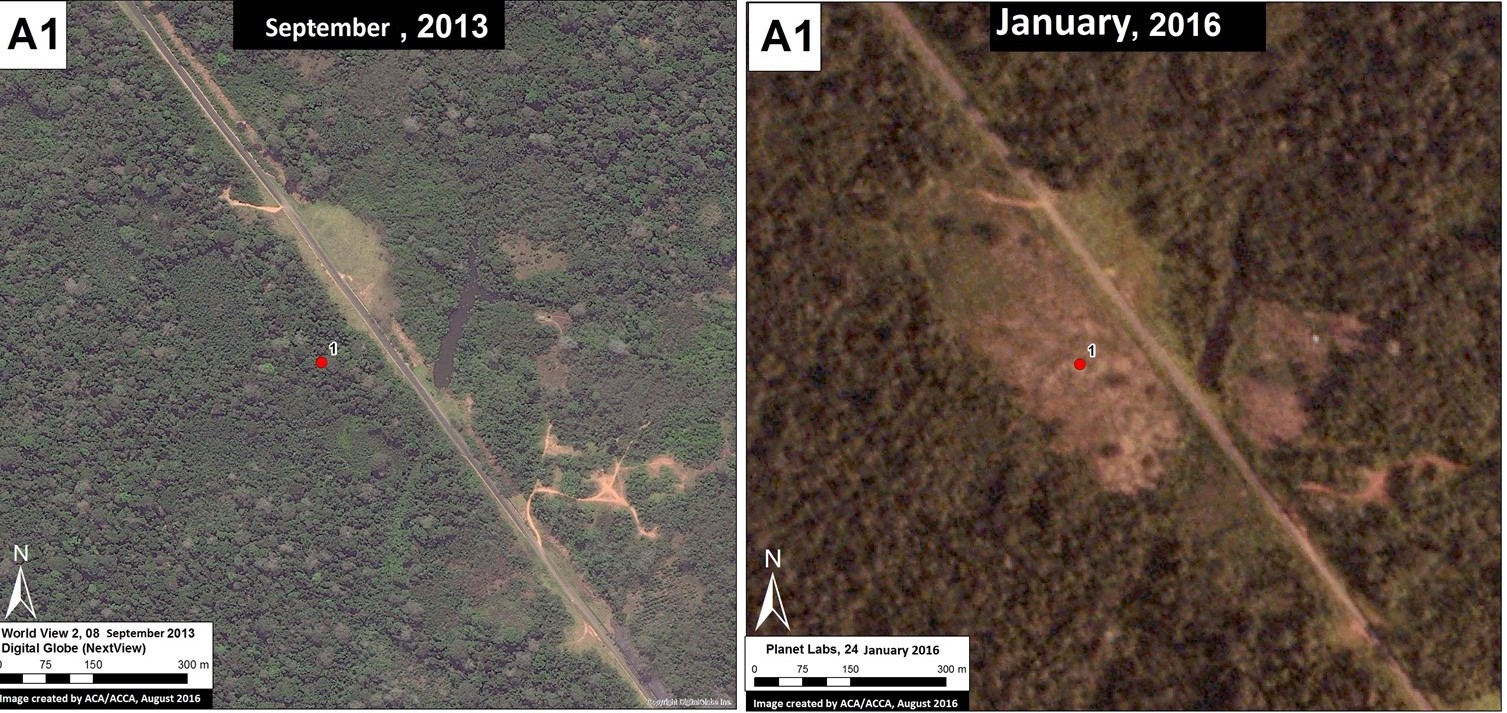
Image 42b shows the deforestation of 12 hectares between September 2013 (left panel) and January 2016 (right panel). The red point indicates the same place in both images. Image 42c is a photo of the new papaya plantation in this area.

Image 42b. Data: Digital Globe (Nextview), Planet Labs
c. point-37-source-minam---dgot-detection-by-terra-i-8132014-driver-papaya_25582479922_o
Image 42c. Photo: MINAM/DGOT, Terra-i

Example #2

Image 42d shows the deforestation of 5 hectares between September 2013 (left panel) and January 2016 (right panel). The red point indicates the same place in both images. Image 42e is a photo of the new papaya plantation in this area.

Image 42d. Digital Globe (Nextview), Planet Labs
e. point-11-source-minam-detection-by-terra-i-112015-driver-papaya_25051222004_o
Image 42e. Photo: MINAM/DGOT, Terra-i

Example #3

Image 42f shows the deforestation of 5 hectares between September 2013 (left panel) and January 2016 (right panel). The red point indicates the same place in both images. Image 42g is a photo of the new papaya plantation in this area.

Image 42f. Digital Globe (Nextview), Planet Labs
Imagen G. MINAM/DGOT, Terra-i
Image 42g. MINAM/DGOT, Terra-i

Example #4

Image 42h shows the deforestation of 12 hectares between September 2013 (left panel) and May 2016 (right panel). The red point indicates the same place in both images. Image 42i is a photo of the new papaya plantation in this area.

Image 42h. MINAM/DGOT, Terra-i
Imagen I. MINAM/DGOT, Terra-i
Image 42i. Photo: MINAM/DGOT, Terra-i

Example #5

Image 42j shows the deforestation of 9 hectares between April 2015 (left panel) and May 2016 (right panel). The yellow boxes indicate the same place in both images. Image 42k is a photo of the new papaya plantation in this area.

Image 42j. MINAM/DGOT, Terra-i
Imagen J. MINAM/DGOT, Terra-
Image 42k. Photo: Farah Carrasco

Citation

Finer M, Novoa S, Carrasco F (2016) Papaya – Potential New Driver of Deforestation in Madre de Dios. MAAP: 42.

MAAP #29: Construction of New Road between Manu National Park and Amarakaeri Communal Reserve (Madre de Dios)

Here in MAAP #29, we describe the Nuevo Eden-Boca Manu-Boca Colorado road project in the southern Peruvian Amazon (Madre de Dios region). The objective of this article is to show the current state of construction and quantify the direct and indirect deforestation caused thus far by the road. This is a controversial road project because it cuts through the buffer zones of two important protected areas, the Amarakaeri Communal Reserve and Manu National Park*.

MAAP_Manu_a_m_v1_en
Image 29a. Data: SERNANP, USGS, MINAGRI, IBC, CLASlite, PNCB/MINAM, Hansen/UMD/Google/USGS/NASA, SPOT

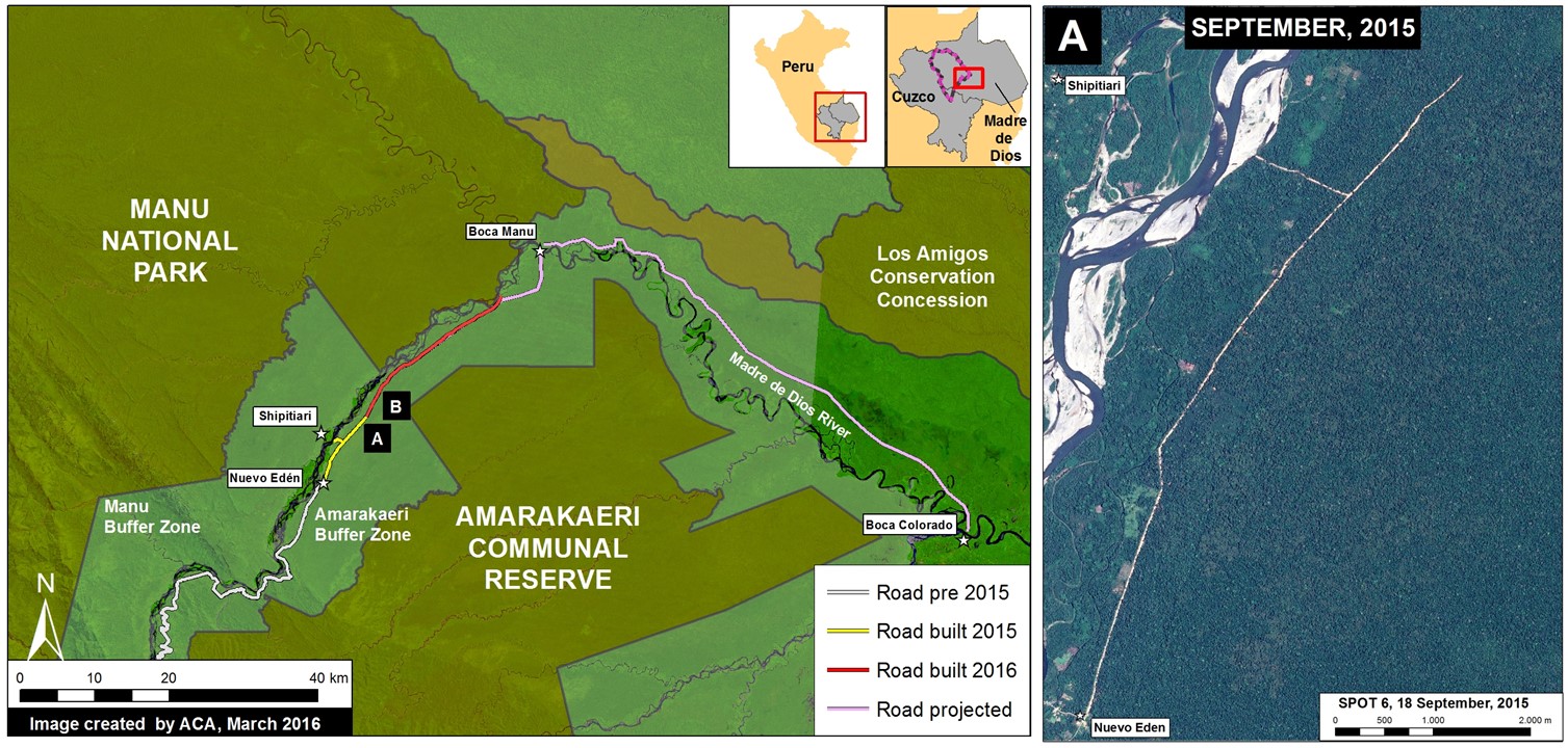
Image 29a shows the general context of the area between Amarakaeri  and Manu where the road is being constructed. The yellow line indicates the section of road built in 2015 (11.6 km) between the towns of New Eden and Shipetiari (see right panel for high-resolution image of this construction). The red line indicates the new section under construction thus far in 2016 (21.8 km). Thus, in total, we have documented the construction of 33.4 km of road within the Amarakaeri Communal Reserve buffer zone. Finally, the pink line indicates the future road section planned to Boca Manu and then to Boca Colorado.

Road Construction in 2015

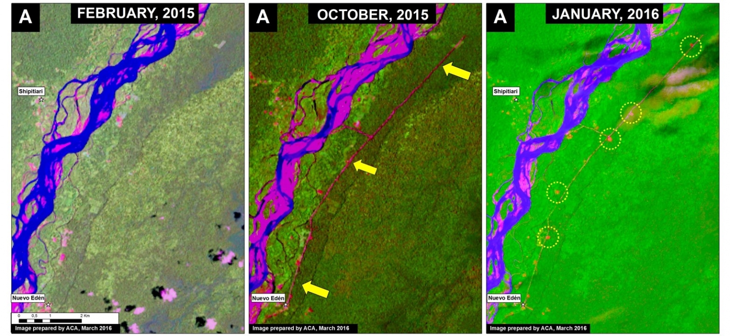
Image 29b shows a series of satellite images (Landsat) that illustrate the rapid road construction during 2015. The first two panels show the construction of 11.6 km between February (left panel) and October (central panel) 2015. The yellow arrows in the central panel indicate the direct deforestation (20 hectares) associated with construction of the route. The yellow circles in the right panel indicate the indirect (secondary) deforestation associated with the road (12 hectares). Thus, in total, we have documented the deforestation of 32 hectares (or 79 acres) associated with the road as of mid-March 2016.

MAAP_Manu_c_m_v1_en
Image 29b. Data: NASA/USGS.

New Road Construction in 2016

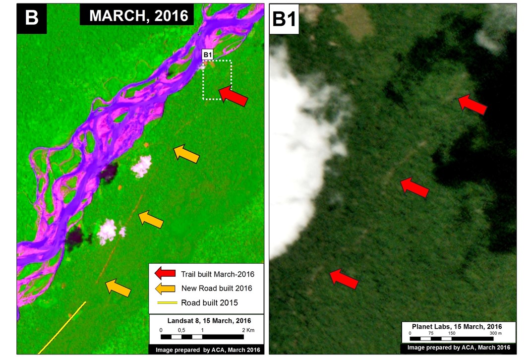
Image 29c shows the continued road construction (2.9 km) between January and mid-March 2016 (see orange arrows in the left panel). Moreover, using high-resolution imagery provided by Planet Labs, the right panel shows a new path (see red arrows) that is likely the leading edge of the current road construction. This path now extends an additional 19 km in the direction of Boca Manu (see Image 29d).

MAAP_Manu_e_m_v1_en
Image 29c. Data: NASA/USGS, Planet Labs
Imagen Xd. Datos: USGS
Image 29d. Data: NASA/USGS

References

*MINAM (2016) MINAM está en contra de predictamen que permitiría la construcción de la carretera en zona de amortiguamiento del Manu y de Amarakaeri. http://www.minam.gob.pe/perucrecimiento/2016/02/29/minam-esta-en-contra-de-predictamen-que-permitiria-la-construccion-de-la-carretera-en-zona-de-amortiguamiento-del-manu-y-de-amarakaeri/

MINAM (2015) MINAM y SERNANP manifiestan preocupación por aprobación de ley que declara de interés nacional carretera en zona de amortiguamiento del Manu y Amarakaeri. http://www.minam.gob.pe/notas-de-prensa/minam-y-sernanp-manifiestan-preocupacion-por-aprobacion-de-ley-que-declara-de-interes-nacional-carretera-en-zona-de-amortiguamiento-del-manu-y-amarakaeri/

Citation

Finer M, Novoa S, Olexy T (2016) Construction of a New Highway between Manu National Park and Amarakaeri Communal Reserve (Madre de Dios), 2016. MAAP: 29.

MAAP #28: New Deforestation Hotspot along Interoceanic Highway in Southern Peruvian Amazon (Madre de Dios)

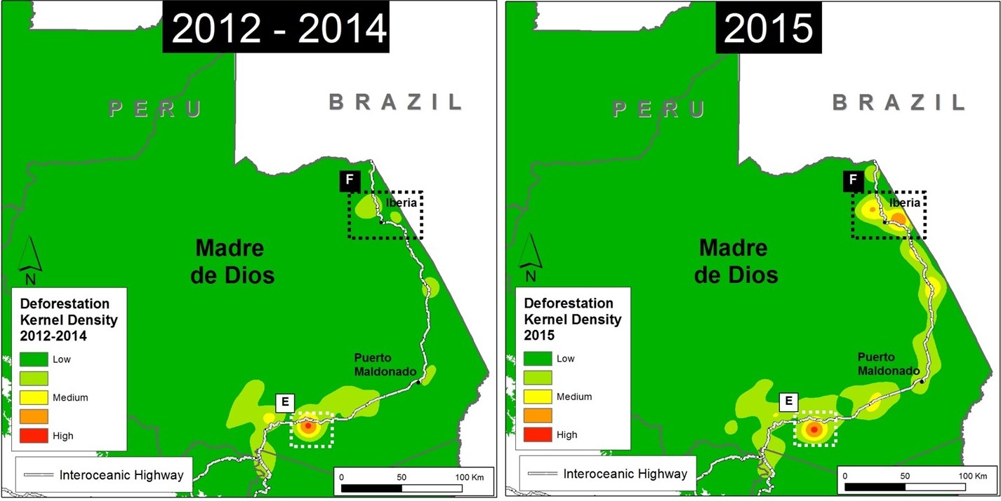
We have previously detailed the extensive illegal gold mining problem in the southern Peruvian Amazon (Madre de Dios region), but here in MAAP #28 we detail the emergence of another deforestation hotspot in the region. Image 28a shows the intensification of this hotspot, located along the newly paved Interoceanic highway around the town of Iberia (see Inset F), between 2012-14 (left panel) and 2015 (right panel). Note that the gold mining hotspot, indicated by Inset E, remained consistently high among the two time frames.

Image 28a. UMD/GLAD, PNCB/MINAM

2015 Deforestation Hotspot Base Map

Image 28 b. UMD/GLAD

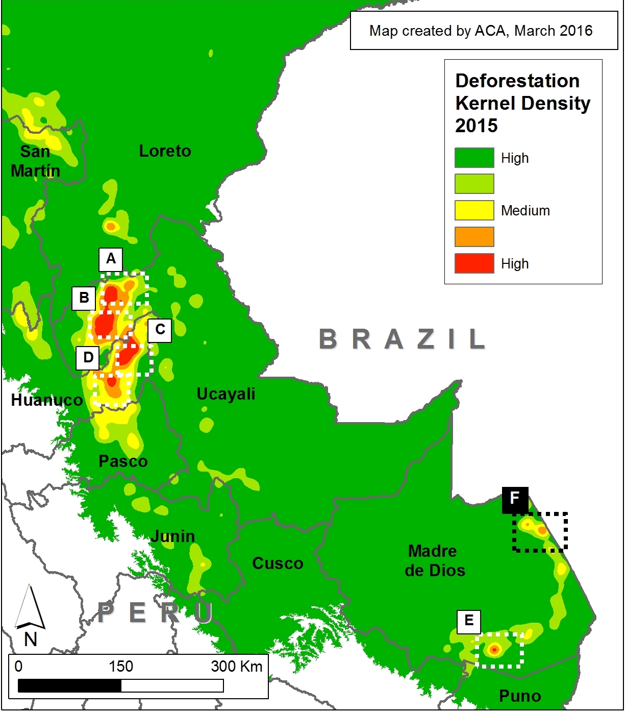
This analysis builds off the previous MAAP #26, where we presented an initial map of “Deforestation hotspots in the Peruvian Amazon in 2015,” based on an analysis of data from the new GLAD* alerts.

Image 28b shows an updated version of the 2015 Peruvian Amazon deforestation hotspots map. Inset F shows the new hotspot featured in this article (see details below).

Note about the Hotspots: Insets A and B indicate two hotspots in the Ucayali region – see MAAP #26 for more detail. Insets C and D indicate two hotspots in Huánuco that we are currently analyzing. Inset E indicates the illegal gold mining zone known as La Pampa, described in various MAAP articles (for example, see MAAP #12). Inset F shows the area of interest in this article.


New Deforestation Front

Image 28c.
Image 28c. PNCB/MINAM, Hansen/UMD/Google/USGS/NASA, UMD/GLAD, MTC, MINAGRI

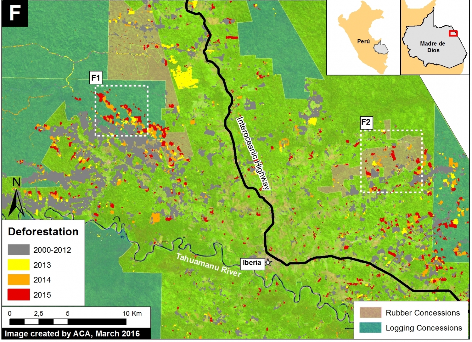
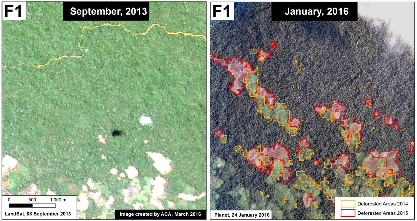
Image 28c shows detailed information about the deforestation surrounding the town of Iberia in northeast Madre de Dios (see Inset F in Image 28a for context).

Note the extensive deforestation in both 2014 and 2015 along both sides of the Interoceanic highway (1,830 hectares, or 4,522 acres).

Also note that much of the deforestation is an agglomeration of small-scale patches and occurs within forestry concessions (timber and rubber harvesting).

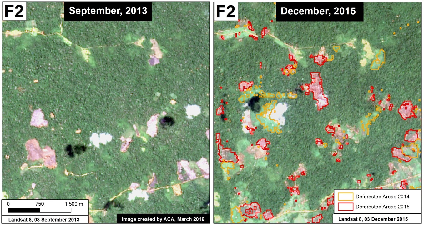
Insets F1 and F2 show the zooms described in greater detail below.


Zoom F1

Image 28d compares two satellite images of the area indicated in Inset F1 (see Image 28c for context) between September 2013 (left panel) and January 2016 (right panel). Note the large increase in newly deforested areas for what appears to be small-scale agricultural inside a timber concession.

Image 28d. Data: USGS, Planet Labs
Image 28d. Data: NASA/USGS, Planet Labs, PNCB/MINAM, UMD/GLAD

Zoom F2

Image 28e compares satellite images of the area indicated in Inset F2 (see Image 28c for context) between September 2013 (left panel) and December 2015 (right panel). Note the large increase in newly deforested areas for what appears to be small-scale agricultural within a rubber concession.

Image 28e. Data: USGS, PNCB/MINAM, UMD/GLAD
Image 28e. Data: NASA/USGS.

References

* Produced by the University of Maryland, Google, and WRI’s Global Forest Watch. http://www.globalforestwatch.org/map/5/-9.31/-75.01/PER/grayscale/umd_as_it_happens

*Hansen, M.C., A. Krylov, A. Tyukavina, P.V. Potapov, S. Turubanova, B. Zutta, S. Ifo, B. Margono, F. Stolle, and R. Moore. Humid tropical forest disturbance alerts using Landsat data. Environ. Res. Lett. 11: 034008.

Citation

Finer M & Novoa S (2016) New Deforestation Hotspot in Madre de Dios, 2016. MAAP: 28.


MAAP Synthesis #1: Patterns and Drivers of Deforestation in the Peruvian Amazon

We present a preliminary analysis of current patterns and drivers of deforestation in the Peruvian Amazon. This analysis is largely based on the first 15 articles published on MAAP between April and September 2015, but also incorporates information from other relevant sources. We describe this analysis as preliminary because as MAAP research continues, we will be able to improve and refine our synthesis in subsequent editions.

MAAP_Synthe_Sa_v4_en
Image S1a. Recent patterns and drivers of deforestation in the Peruvian Amazon. Numbers indicate relevant MAAP article. Data: SERNANP, IBC, MINAM-PNCB/MINAGRI-SERFOR, MAAP.

Introduction & Summary of Key Results

Image S1a illustrates recent (2000 – 2013) patterns of deforestation in the Peruvian Amazon based on data from the Peruvian Ministries of Environment[i] and Agriculture[ii]. These two Ministries have documented a total forest loss of around 1.65 million hectares (ha) in the Peruvian Amazon between 2001 and 2014, with an increasing trend in recent years (2014 had the highest forest loss on record with 177,571 ha)[iii],[iv]. Another recent report by the Peruvian government stated that the majority (75%) of the Amazonian deforestation is due to small-scale clearings related to agriculture and livestock activities, usually near roads or rivers[v].

Building off of that historical and annual information, our goal at MAAP is to monitor deforestation in near real-time. Since April 2015, we have published numerous articles analyzing areas in the northern, central, and southern Peruvian Amazon. In this initial analysis, we have found that three of the most important drivers of deforestation are large-scale oil palm (and cacao) plantations, gold mining, and coca cultivation. We also found a growing network of logging roads that contribute to forest degradation. Image S1a displays the general geographic distribution of these drivers of deforestation and degradation.

We estimate that around 30,000 hectares of primary forest was cleared since 2000 for large-scale oil palm and cacao plantations. Cacao has recently joined oil palm as a deforestation driver due to the arrival of the company United Cacao and their implementation of the large-scale agro-industrial model in place of traditional small-scale plantations on previously degraded lands.

Gold mining has directly caused the deforestation of over 43,000 ha since 2000, mostly in the region of Madre de Dios. In recent years, this deforestation has been concentrated in the Tambopata National Reserve buffer zone.

Although coca cultivation is reportedly declining in Peru, we found that it remains a major driver of deforestation, particularly within and around remote protected areas. For example, we documented 143 ha of coca related deforestation within the Sierra del Divisor Reserved Zone, and an additional 2,638 ha related to shifting agricultural cultivation, which includes coca, within and around Bahuaja Sonene National Park.

We also documented a recent expansion of logging roads in the central Peruvian Amazon. This finding is significant because it is difficult to detect selective logging in satellite imagery, but now we can at least detect the roads that indicate that selective logging is taking place in a given area.

We identified some important geographic patterns related to the four drivers described above. For example, large-scale oil palm (and cacao) are concentrated in the northern Peruvian Amazon, while gold mining deforestation has largely been in the south. Coca-driven deforestation appears to be particularly problematic in the southern Peruvian Amazon, but also exists in the north. The construction of new logging roads is currently most active in the central Peruvian Amazon.

The documented deforestation is caused by both illegal and legal means. For the former, there is extensive deforestation from illegal gold mining and coca cultivation. Regarding the latter, oil palm and cacao companies are exploiting loopholes in the Peruvian legal framework that facilitate large-scale deforestation for agricultural projects.

Large-scale Agriculture (Oil Palm and Cacao)

MAAP_Synthe_Sb_v4_en
Image S1b. Large-scale agriculture deforestation in the northern Peruvian Amazon. Numbers indicate relevant MAAP article. Data: SERNANP, IBC, MINAM-PNCB/MINAGRI-SERFOR, MAAP.

Image S1b illustrates that large-scale agriculture (namely oil palm and cacao) is an important cause of deforestation in northern Peru.

Importantly, several oil palm and cacao companies are changing the production model in Peru from small-scale to large-scale agro-industrial. For example, in a recent interview, United Cacao CEO Dennis Melka stated that his company is trying to replicate the agro-industrial model used by oil palm companies in Southeast Asia[vi].

This shift is noteworthy because large-scale plantations usually come at the expense of forests, while small-scale plantations are better able to take advantage of previously cleared lands[vii]. We estimate that over 30,000 hectares of primary forest was cleared since 2000 for large-scale oil palm and cacao plantations (see below). Much less primary forest, around 575 ha, was cleared for small-scale oil palm (we have yet to evaluate small-scale cacao).

Note that we emphasize the clearing of primary forest. We conducted an additional analysis to determine whether oil palm (both small and large-scale) and cacao (just large-scale) plantations were originally sited on lands with primary forest, secondary forest, or already deforested. We defined primary forest as an area that from the earliest available Landsat, in this case 1990, was characterized by dense closed canopy forest cover.

The following is a concise breakdown of how we calculated the 30,000 ha of primary forest loss from large-scale plantations.

MAAP articles #2, #9, and #13 demonstrated that 2,276 ha of primary forest was cleared by United Cacao between May 2013 and September 2015 outside of the town of Tamshiyacu in the northern Peruvian Amazon (Loreto region).

MAAP article #4 detailed the deforestation of 9,400 ha of primary forest (plus an additional 2,350 ha of secondary forest) between 2011 and 2015 for two large-scale oil palm projects near the town of Nueva Requena in the central Peruvian Amazon (Department of Ucayali).

In addition, yet unpublished MAAP analysis shows that in Palmas de Shanusi/Oriente (oil palm projects operated by the company Grupo Palmas), 6,974 ha of primary forest were cleared between 2006 and 2011, although the legally mandated 30% forest cover reserves were maintained. An additional 8,225 ha of primary forest was cleared in areas immediately surrounding the concessions.

Finally, although not yet published on MAAP, we also documented nearly 3,500 ha of primary forest loss in other large-scale oil palm projects in San Martin and Ucayali regions.

It is important to emphasize that several oil palm and cacao companies are exploiting various loopholes in the Peruvian legal framework that facilitate large-scale deforestation for agricultural projects[viii]. In fact, these companies argue that according to Peruvian law, they are engaged in legal “forest clearing”, not illegal “deforestation”[ix].

Gold Mining

MAAP_Synthe_Sc_v4_en
Image S1c. Gold mining deforestation in the Peruvian Amazon. Numbers indicate relevant MAAP article. Data: SERNANP, IBC, MINAM-PNCB/MINAGRI-SERFOR, MAAP.

Image S1c illustrates that gold mining-driven deforestation is largely concentrated in the southern Peruvian Amazon, particularly in the region of Madre de Dios and adjacent Cusco.

According to the scientific literature, gold mining deforestation in Madre de Dios increased from 10,000 ha in 2000 to 50,000 ha in 2012[x]. MAAP articles #1, #5, and #12 documented the deforestation of an additional 2,774 ha between 2013 and 2015 in two gold mining hotspots (La Pampa and Upper Malinowski), both of which are located within the buffer zone of the Tambopata National Reserve. In addition, MAAP #6 showed gold mining deforestation expanding from another Madre de Dios gold mining hotspot (Huepetuhe) into the tip of Amarakaeri Communal Reserve (11 ha).

Much of the Madre de Dios gold mining deforestation described above is illegal because it is occurring within and around protected areas where mining is not permitted under the government-led formalization process.

MAAP articles #6 and #14 detailed recent gold mining deforestation in the region of Cusco. Specifically, we documented the deforestation of 967 ha along the Nuciniscato River and its major tributaries since 2000 (with the vast majority occurring since 2010). Much of this deforestation appears to be linked to gold mining.

Thus, the total documented gold mining deforestation in Madre de Dios and adjacent Cusco is at least 53,750 ha[xi], over 80% of which has occurred since 2000. This total is an underestimate since we have not yet done detailed studies for 2013 – 2015 deforestation in all of the known gold mining zones in these two regions.

In addition, MAAP #7 showed two gold mining zones in the region of Ucayali (along the Sheshea and Abujao Rivers, respectively). Much of this deforestation occurred between 2000 and 2012.

Finally, there are also reports of extensive gold mining in northern Peru (the regions of Amazonas and Loreto) but we do not yet have data showing that it is causing deforestation.

Coca

MAAP_Synthe_Sd_v4_en
Image S1d. Coca cultivation areas in the Peruvian Amazon. Numbers indicate relevant MAAP article. Data: UNODC 2014, MINAM-PNCB/MINAGRI-SERFOR, SERNANP, NatureServe.

Although the most recent report from the United Nations Office on Drugs and Crime (UNODC) indicates that overall coca cultivation is declining in Peru[xii], our research finds that it remains a major driver of deforestation in certain areas, particularly within and around several remote protected areas.

Image S1d displays the distribution of current coca-cultivation areas (in relation to protected areas) based on the data from the latest United Nations report. Of these areas, we have thus far focused on the three detailed below.

MAAP articles #7 and #8 show recent coca-related deforestation within the southern section of the Sierra del Divisor Reserved Zone. This area is particularly important because it is soon slated to be upgraded to a national park. Specifically, we documented coca-related deforestation of 130 ha between 2013 and 2014 within the southwestern section of the reserve, and, most recently, a new plantation of 13 ha during June 2015 within the southeast section.

MAAP article #10 revealed that shifting agricultural cultivation, that includes coca, is also a major issue within and around Bahuaja Sonene National Park, located in the southern Peruvian Amazon. Specifically, we found the recent deforestation of 538 hectares within the southern section of the Park, and an additional 2,100 hectares in the surrounding buffer zone. Much of this deforestation is likely linked to coca cultivation since the latest United Nations report indicates these areas contain high coca plantation densities.

MAAP article #14 documents the deforestation of 477 ha along the Nojonunta River in Cusco since 2000 (with a major peak since 2010). Much of this deforestation is likely linked to coca cultivation since the latest United Nations report indicates these areas contain medium to high coca plantation densities. 

Logging Roads

MAAP_Synthe_Se_v4_en
Image S1e. Logging roads in the Peruvian Amazon. Numbers indicate relevant MAAP article. Data: SERNANP, IBC, MINAM-PNCB/MINAGRI-SERFOR, MINAGRI, MAAP.

One of the major advances discovered in this work is the ability to identify the expansion of new logging roads. This advance is important because it is extremely difficult to detect illegal logging in satellite imagery because loggers in the Amazon often selectively cut high value species and do not produce large clearings. But now, although it remains difficult to detect the actual selective logging, we can detect the roads that indicate that selective logging is taking place in that area.

Image S1e illustrates the likely logging roads that we have recently detected. Of these areas, we have thus far focused on the two detailed below.

MAAP article #3 shows the rapid proliferation of two new road networks in the northern Peruvian Amazon (Loreto region). Most notably, it highlights the construction of 148 km of new roads, possibly illegal logging roads, through mostly primary forest between 2013 and 2014. One of the roads is within the buffer zone of the Cordillera Azul National Park.

In addition, MAAP article #7 shows the expansion of new logging roads near both the southern and northwestern sections of the Sierra del Divisor Reserved Zone. In both cases, the expansion is very recent (between 2013 and 2015).


[i] National Program of Forest Conservation for the Mitigation of Climate Change – PNCB.

[ii] Servicio Nacional Forestal y de Fauna Silvestre – SERFOR

[iii] MINAGRI-SERFOR/MINAM-PNCB (2015) Compartiendo una visión para la prevención, control y sanción de la deforestación y tala ilegal.

[iv] Note that some of the documented forest loss may come from natural causes, such as landslides or meandering rivers.

[v] MINAM (2013) Fondo Cooperativo Para El Carbono de los Bosques (FCPF) Plantilla de Propuesta para la Fase de Preparación para REDD+ (Readiness Plan Proposal – RPP). Link: http://www.minam.gob.pe/cambioclimatico/wp-content/uploads/sites/11/2014/03/R-PP-Per%C3%BA-Final-Dec-2013-RESALTADO_FINAL_PUBLICADA-FCPF_24-febrero.pdf

[vi] NF Joan (2015) United Cacao replicates Southeast Asia’s plantation model in Peru, says CEO Melka. The Edge Singapore.Link: http://www.unitedcacao.com/images/media-articles/20150713-the-edge-united-cacao.pdf

[vii] Gutiérrez-Vélez VH, DeFries R, Pinedo-Vásquez M, et al. (2011) High-yield oil palm expansion spares land at the expense of forests in the Peruvian Amazon. Environ. Res. Lett., 6, 044029. Link: http://iopscience.iop.org/article/10.1088/1748-9326/6/4/044029/pdf

[viii] Environmental Investigation Agency (2015) Deforestation by Definition. Washington, DC. Link: http://eia-global.org/news-media/deforestation-by-definition

[ix] Tello Pereyra R (2015) Situacion legal, judicial, y administrativa de  Cacao del Peru Norte SAC. Link: https://www.youtube.com/watch?v=p_YIe70u1oA

[x] Asner GP, Llactayo W, Tupayachia R, Ráez Luna E (2013) PNAS 110 (46) 18454-18459. Link: http://www.pnas.org/content/110/46/18454.abstract

[xi] That is, 50,000 ha from the literature and 3,750 ha from MAAP analysis.

[xii] UNODC (2015) Monitoreo de cultivos ilícitos Perú 2014. Link: https://www.unodc.org/documents/crop-monitoring/Peru/Peru_Informe_monitoreo_coca_2014_web.pdf

Citation

Finer M, Novoa S (2015) Patterns and Drivers of Deforestation in the Peruvian Amazon. MAAP Synthesis #1. Link: https://www.maaproject.org/2015/09/maap-synthesis1/