MAAP #136: Amazon Deforestation 2020 (Final)
*To download the report, click “Print” instead of “Download PDF” at the top of the page. In January, we presented the first look at 2020 Amazon deforestation based on early warning alert data (MAAP #132). Here, we update this analysis…
MAAP #132: Amazon Deforestation Hotspots 2020
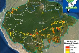
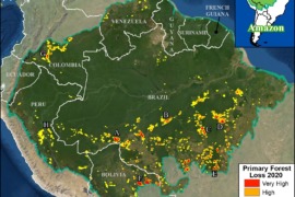
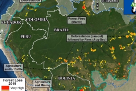
We present a first look at the major hotspots of primary forest loss across the Amazon in 2020 (see Base Map).* There are several major headlines: We estimate over 2 million hectares (5 million acres) of primary forest loss across…
MAAP #129: Amazon Fires 2020 – Recap of Another Intense Fire Year
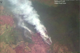
Following the intense Amazon fire season of 2019 that made international headlines, here we report another major fire year in 2020. Using the novel data from our real-time Amazon Fires Monitoring app,* we documented over 2,500 major fires across the…
MAAP: Fires in the Bolivian Amazon 2020
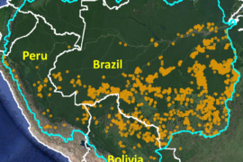
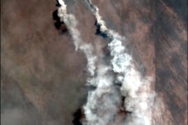
We have detected 120 major fires this year in the Bolivian Amazon, as of the first of October (see Base Map).* The majority of these fires (54%) occurred in savannas, located in the department of Beni. Another 38% of the…
Amazon Fire Tracker 2020: End of August Update (Over 600 Major Fires)
August 2020 just ended its run as a severe Amazon fire month. k Our novel Real-time Amazon Fire Monitoring app has detected 646 major fires in the Brazilian Amazon thus far in 2020.* k Of these, 88% (569 major fires)…
MAAP #122: Amazon Deforestation 2019
Newly released data for 2019 reveals the loss of over 1.7 million hectares (4.3 million acres) of primary Amazon forest in our 5 country study area (Bolivia, Brazil, Colombia, Ecuador, and Peru).* That is twice the size of Yellowstone National…
MAAP Synthesis: 2019 Amazon Deforestation Trends and Hotspots
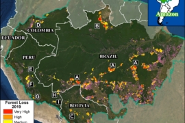
MAAP, an initiative of Amazon Conservation, specializes in satellite-based, real-time deforestation monitoring of the Amazon. Our geographic focus covers five countries: Bolivia, Brazil, Colombia, Ecuador, and Peru (see Base Map). We found that, since 2001, this vast area lost 65.8…
Amazon Deforestation Trends, 2001-2019
These graphs correspond to MAAP Synthesis: 2019 Amazon Deforestation Trends and Hotspots.…
MAAP #112: Mennonite Colonies – New Deforestation Driver in the Amazon
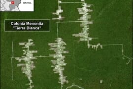
The Mennonites, a religious (Christian) group often dedicated to organized agriculture, are increasingly inhabiting the western Amazon (Peru and Bolivia). Here, we reveal the recent deforestation of 18,500 acres (7,500 hectares) in three Mennonite colonies (see the Base Map below).…
MAAP #111: Fires in the Bolivian Amazon – Using Google Earth Engine to Monitor
We begin a new series on how to harness the power of the cloud to improve real-time monitoring in the Amazon and beyond. As the amount of data from satellite images has skyrocketed, so have the challenges of research teams…