MAAP #164: Amazon Tipping Point – Where Are We?
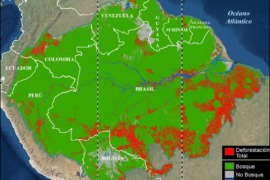
It is increasingly reported that the largest rainforest in the world, the Amazon, is rapidly approaching a tipping point. As repeatedly highlighted by the late Tom Lovejoy (see Acknowledgements), this tipping point is where parts of the rainforest will convert…
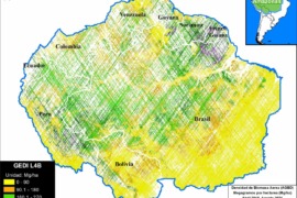
MAAP #160: Lasers Estimate Carbon in the Amazon – NASA’s GEDI Mission
NASA’s GEDI mission uses lasers to provide cutting-edge estimates of aboveground biomass and related carbon on a global scale. Launched in late 2018 and installed on the International Space Station, GEDI’s lasers return an estimate of aboveground biomass density at…
MAAP #158: Amazon Deforestation & Fire Hotspots 2021
We present a detailed look at the major 2021 Amazon forest loss hotspots, based on the final annual data produced by the University of Maryland. This dataset is unique in that distinguishes forest loss from fire, leaving the rest as…
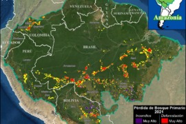
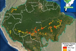
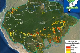
MAAP #153: Amazon Deforestation Hotspots 2021
We present a first look at the major 2021 Amazon deforestation hotspots.* The Amazon Base Map illustrates several key findings:p We estimate the loss of over 1.9 million hectares (4.8 million acres) of primary forest loss across the nine countries…
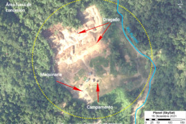
MAAP #151: Illegal Mining in the Ecuadorian Amazon
In this report, we report on illegal gold mining activity in the Ecuadorian Amazon, building off our previous reports on Peru (MAAP #130) and Brazil (MAAP #116). The Base Map shows the two new cases presented below: Yutzupino (Napo province)…
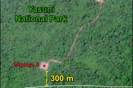
MAAP #150: New Oil Platforms Deeper into Yasuni National Park (Ecuador), towards Uncontacted Indigenous Zone
Yasuni National Park, located in the heart of the Ecuadorian Amazon, is one of the most biodiverse places in the world thanks to its unique location at the intersection of the Amazon, Andes Mountains, and the equator (see Base Map).…
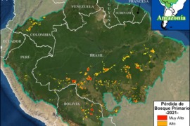
MAAP #147: Amazon Deforestation Hotspots 2021 (1st Look)
We present a first look at the major deforestation hotspots across all nine countries of the Amazon in 2021 (as of September 18).* The Base Map illustrates several key findings thus far in 2021:p We estimate the loss of over…
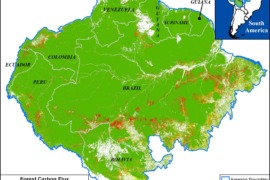
MAAP #144: The Amazon & Climate Change: Carbon Sink vs Carbon Source
A pair of recent scientific studies revealed that parts of the Amazon now emit more carbon into the atmosphere than they absorb (Gatti et al 2021, Harris et al 2021). Here, we dig deeper and highlight the key finding: the…
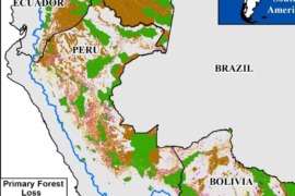
MAAP #141: Protected Areas & Indigenous Territories Effective Against Deforestation in the Western Amazon
As deforestation continues to threaten primary forest across the Amazon, key land use designations are one of the best hopes for the long-term conservation of critical remaining intact forests. Here, we evaluate the impact of two of the most important…
MAAP #136: Amazon Deforestation 2020 (Final)
*To download the report, click “Print” instead of “Download PDF” at the top of the page. In January, we presented the first look at 2020 Amazon deforestation based on early warning alert data (MAAP #132). Here, we update this analysis…