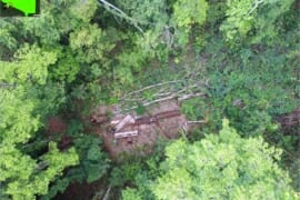
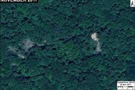
MAAP #105: From satellite to drone to legal action in the Peruvian Amazon
Amazon Conservation, in collaboration with its Peruvian sister organization, is implementing a project aimed at linking cutting-edge technology (satellites and drones) with legal action, in the southern Peruvian Amazon (Madre de Dios region). The project is building a comprehensive deforestation…
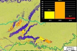
MAAP #104: Major Reduction in Illegal Gold Mining from Peru’s Operation Mercury
In February 2019, the Peruvian government launched Operation Mercury (Operación Mercurio), a major multi-sectoral crackdown on the illegal gold mining crisis in the area known as La Pampa,* located in the southern Peruvian Amazon (Madre de Dios region). Note that…
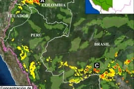
MAAP #100: Western Amazon – Deforestation Hotspots 2018 (a regional perspective)
For the 100th MAAP report, we present our first large-scale western Amazon analysis: Colombia, Peru, Ecuador, Bolivia, and western Brazil (see Base Map). We use the new 2018 data for forest cover loss, generated by the University of Maryland (Hansen…
MAAP #99: Detecting Illegal Logging in the Peruvian Amazon
In the Peruvian Amazon, most of the logging is selective (not clearcutting), with the targets being higher-value species. Thus, illegal logging is difficult to detect with satellite imagery. In MAAP #85, however, we presented the potential of satellite imagery in…
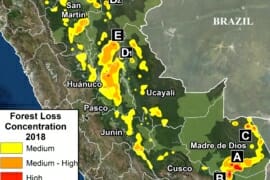
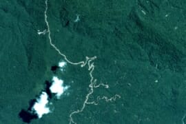
MAAP #98: Deforestation Hotspots in the Peruvian Amazon, 2018
Thanks to early warning forest loss alerts,* we are able to make an initial assessment of the 2018 deforestation hotspots in the Peruvian Amazon. The Base Map highlights the medium (yellow) to high (red) hotspots. In this context, hotspots are…
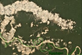
MAAP #96: Gold Mining Deforestation at Record High Levels in Southern Peruvian Amazon
Gold mining deforestation has been at record high levels in both 2017 and 2018 in the southern Peruvian Amazon. Based on an analysis of nearly 500 high-resolution satellite images (from Planet and DigitalGlobe), we estimate the deforestation of 18,440 hectares …
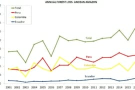
MAAP Synthesis #3: Deforestation in the Andean Amazon (Trends, Hotspots, Drivers)
MAAP, an initiative of the organization Amazon Conservation, uses cutting-edge satellite technology to monitor deforestation in near real-time in the megadiverse Andean Amazon (Peru, Colombia, Ecuador, and Bolivia). The monitoring is based on 5 satellite systems: Landsat (NASA/USGS), Sentinel (European…
MAAP #95: Oil Palm Baseline for the Peruvian Amazon
In previous reports, we have documented that oil palm is one of the deforestation drivers in the Peruvian Amazon (MAAP #41, #48). However, the full extent of this sector’s deforestation impact is not well known. A newly published study assessed…
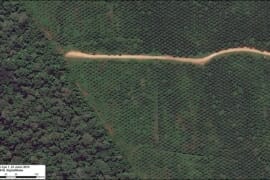
MAAP #94: Detecting Logging in the Peruvian Amazon with High Resolution Imagery
In MAAP # 85, we showed how medium and high-resolution satellites (such as Landsat, Planet and Sentinel-1) could be used to monitor the construction of logging roads in near-real time. Here, we show the potential of very high-resolution satellites (such…
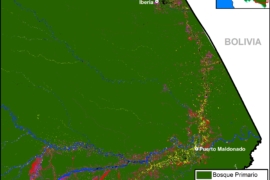
MAAP #93: Shrinking Primary Forests of the Peruvian Amazon
The primary forests of the Peruvian Amazon, the second largest stretch of the Amazon after Brazil, are steadily shrinking due to deforestation. Here, we analyze both historic and current data to identify the patterns. The good news: As the Base…