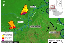
MAAP #80: Amazon Beauty, in High-Resolution
MAAP tracks the most urgent deforestation cases in the Andean Amazon, thus it can be a bit depressing. However, it is important to remember why we do it: the Amazon is spectacular. Here, we present a series of high-resolution satellite…
MAAP Interactive: Deforestation Drivers in the Andean Amazon
Since its launch in April 2015, MAAP has published over 70 reports related to deforestation (and natural forest loss) in the Andean Amazon. We have thus far focused on Peru, with several reports in Colombia and Brazil as well. These…
MAAP #66: Satellite Images of Belo Monte Dam Project (Brazil)
The Belo Monte hydroelectric dam complex, located on the Xingu River in the state of Para in the eastern Brazilian Amazon (see Image 66a), has been controversial since its inception over 15 years ago, due to both environmental and social…
MAAP SYNTHESIS #2: PATTERNS AND DRIVERS OF DEFORESTATION IN THE PERUVIAN AMAZON
We present our second synthesis report, building off our first report published in September 2015. This synthesis is largely based on the 50 MAAP reports published between April 2015 and November 2016. The objective is to synthesize all the information…
MAAP #34: New Dams on the Madeira River in Brazil Cause Forest Flooding
The Amazon lowlands have been connected to the Andes Mountains for millions of years by only six major rivers: the Caqueta, Madeira, Maranon, Napo, Putumayo, and Ucayali* (see Image 34a). This intimate connection allows rich Andean nutrients to fuel the…