MAAP #127: Mennonite Colonies Continue Major Deforestation in Peruvian Amazon
October 26, 2020
The Mennonites, a religious group often associated with organized agricultural activity, have started three new colonies in the Peruvian Amazon.
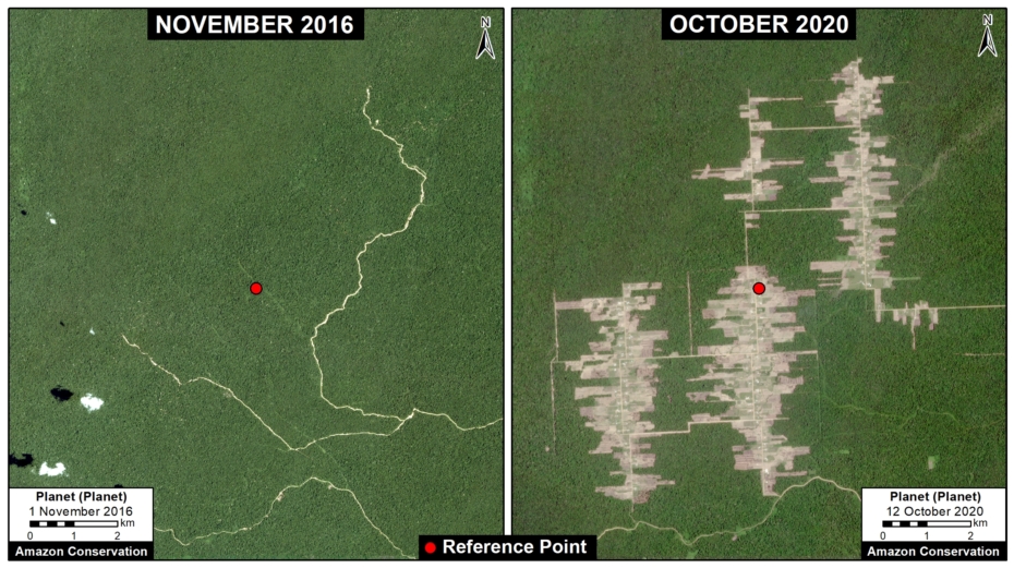
We have documented the deforestation of 8,500 acres (3,440 hectares) in these three colonies over the past four years (updated October 2020).
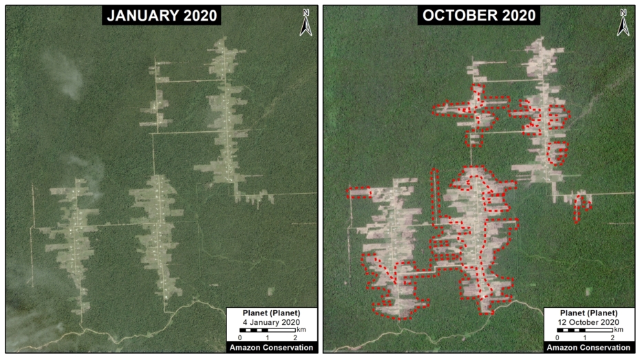
The deforestation started in 2017, but continues to be active in 2020 (with 1,900 acres lost, 25% of the total).
Notably, this combined Mennonite deforestation now exceeds the total loss from the infamous United Cacao case (2,400 hectares), one of the last major controversial large-scale deforestation cases in the Peruvian Amazon (MAAP #27).
Moreover, there are strong indications that the deforestation associated with these three Mennonite colonies is illegal (see Legality Statement below).
Below, we present the following:
- A Base Map showing the location of the three new Mennonite colonies in the Peruvian Amazon.
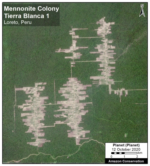
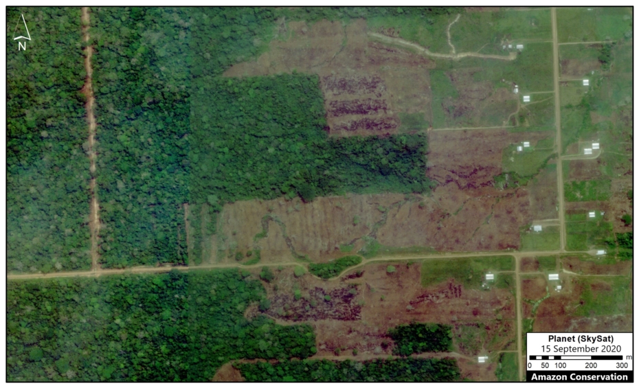
- A series of satellite images showing the recent deforestation in the most active colony (Tierra Blanca 1), including a very high resolution (0.5 meter) Skysat image.
- a Legality Statement.
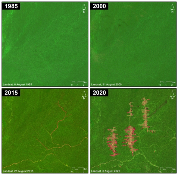
- A graphic showing that the deforested area was not previously cleared (that is, it was intact forest).
Base Map
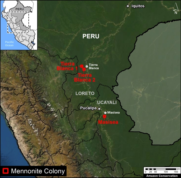
The Base Map shows the location of the three new Mennonite colonies in the Peruvian Amazon.
Two colonies are located near the town of Tierra Blanca in the northern Peruvian Amazon (Loreto region).
The other colony is located near the town of Masisea in the central Peruvian Amazon (Ucayali region).
Of the total deforestation (8,500 acres):
- 63% (5,370 acres) is from the colony Tierra Blanca 1;
- 25% (2,145 acres) is from the colony Masisea;
- 12% (990 acres) is from the colony Tierra Blanca 2.
Deforestation 2017-20
The following image shows the total deforestation of 5,370 acres (2,174 hectares) between November 2016 (left panel) and October 2020 (right panel), associated with the Mennonite colony Tierra Blanca 1. The red dot serves as a reference point between the two panels. Click to enlarge.
Deforestation 2020
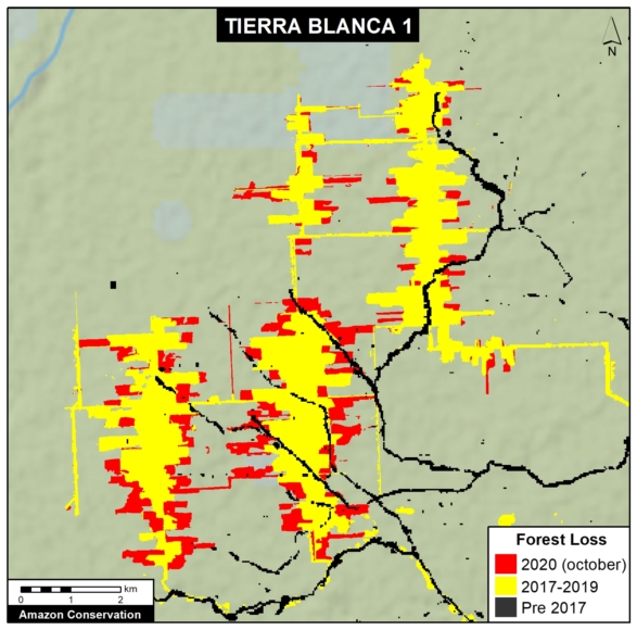
The following image shows the most recent deforestation of 1,540 acres (625 hectares) between January 2020 (left panel) and October 2020 (right panel), associated with the Tierra Blanca 1 Mennonite colony. The red lines indicate new 2020 deforestation. Also see the Annex below for a map of the 2020 deforestation in relation to previous 2017-19 deforestation. Click to enlarge.
Very High Resolution Satellite Image (Skysat)
We recently obtained a very high resolution (0.5 meter) satellite image of the Tierra Blanca 1 colony, thanks to the company Planet and their Skysat fleet. The image allows enhanced visualization of some details of the deforested area, such as roads, buildings, and cleared land for likely agricultural activities. Click to enlarge.
Legality Statement
Regarding the findings in Loreto (Tierra Blanca), we consulted with the Regional Government of Loreto who, in a document dated October 15, 2020, indicated that the Mennonite colonies do not have any approvals for the large-scale forest clearing in the area. The documented also indicated that they were coordinating with the environmental prosecutor’s office (known as FEMA) to investigate the case and its environmental impact.
Regarding the findings in Ucayali (Massisea), our investigations revealed that there is an investigation in progress by the environmental prosecutor’s office (FEMA). In addition, the regional government has initiated a sanctioning procedure for the alleged unauthorized land use change (deforestation) associated with Mennonite colony near Masisea.
Annex
We present a time series of satellite images ranging from 1985 to 2020 that shows that the major deforestation in the area began with the Mennonite intervention.
Annex. Deforestation in 2020 in relation to 2017-19, associated with Mennonite colony Tierra Blanca 1. Data: MAAP.
Acknowledgements
We thank S. Novoa and G. Palacios for helpful comments to earlier versions of this report.
This work was supported by the following major funders: Erol Foundation, Norwegian Agency for Development Cooperation (NORAD), and International Conservation Fund of Canada (ICFC).
Citation
Finer M, Mamani N, Suarez D (2020) MAAP: Mennonite Colonies Continue Major Deforestation in Peruvian Amazon Peruana. MAAP: 27.
