MAAP #148: Carbon loss & protection in the Peruvian Amazon
November 5, 2021
Tropical forests store massive amounts of carbon. However, when these forests are cleared (and often subsequently burned), the stored carbon is released into the atmosphere, further driving global climate change.
The Amazon is the world’s largest tropical forest, with Peru forming the second-largest piece, directly to the west of Brazil (the largest).
The Peruvian Amazon is unique in having a high-resolution estimate of aboveground carbon dating back to 2013 (Asner et al 2014).
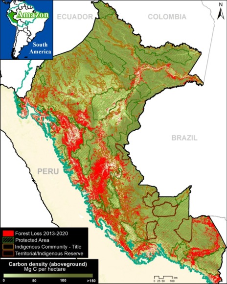
Here, we analyze this dataset in relation to recent deforestation data (see Base Map), seeking to identify the major carbon-related trends between 2013 and 2020.
Our key findings include:
- We estimate the loss of over 100 million metric tons of carbon (101,498,000 MgC) in the Peruvian Amazon between 2013 and 2020, mostly due to deforestation from agriculture and mining.
k - In contrast, we estimate that protected areas and indigenous lands have safeguarded 3.2 billion metric tons of carbon (56% and 44%, respectively) in the Peruvian Amazon between 2013 and 2020.
The carbon loss noted above is equivalent to greenhouse gas emissions from nearly 80 million passenger vehicles driven for one year, or CO2 emissions from 92 coal-fired power plants in one year (EPA).
The carbon protection noted above is equivalent to greenhouse gas emissions from 2.5 billion passenger vehicles driven for one year, or CO2 emissions from nearly 3,000 coal-fired power plants in one year (EPA).
Reference Map
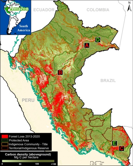
Below, we present a series of zoom images of several key areas.
Zooms A-C highlight recent carbon loss due to deforestation (agriculture and mining) in high carbon density Amazon moist forests.
In contrast, Zooms D-E show how protected areas and indigenous lands are protecting massive amounts of carbon.
These letters (A-E) correspond to the reference map here.
Areas of Recent Carbon Loss
A. United Cacao
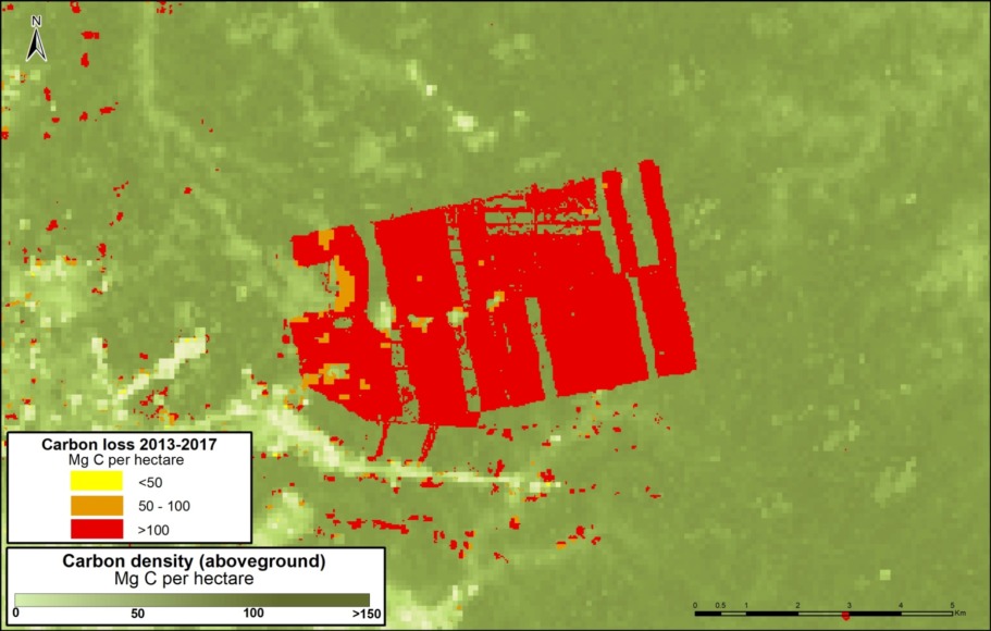
Zoom A shows the loss of nearly 300,000 metric tons of carbon for a large-scale cacao project (United Cacao) in the northern Peruvian Amazon (Loreto region).
B. Mennonite Colony
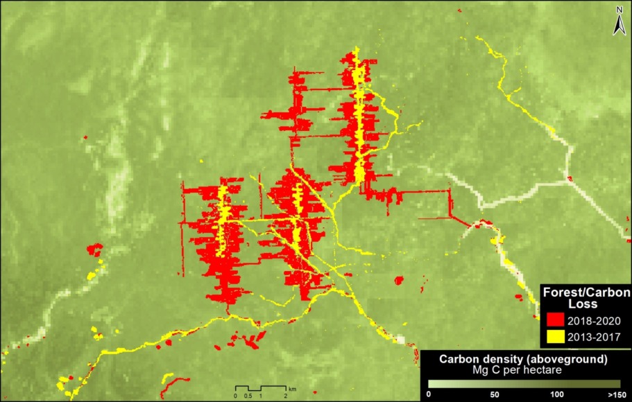
Zoom B shows the recent deforestation and associated carbon loss for a new Mennonite colony in the central Peruvian Amazon (near the town of Tierra Blanca).
C. Gold mining
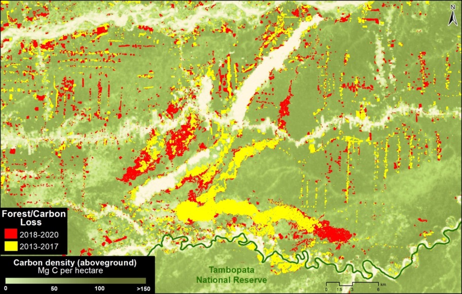
Zoom C shows the loss of over 800,000 metric tons of carbon due to gold mining in the southern Peruvian Amazon (Madre de Dios region).
Areas of Carbon Protection
D. Yaguas National Park
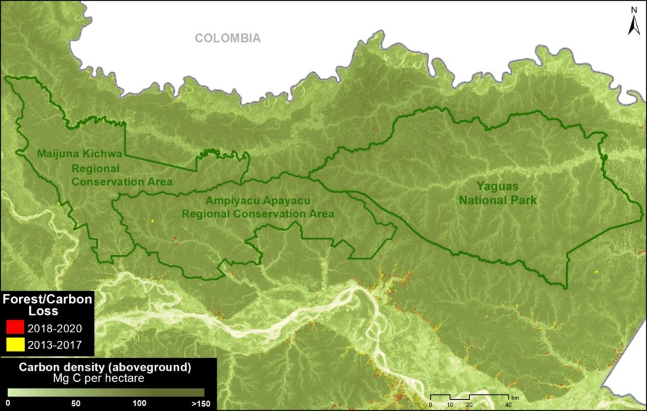
Zoom D shows how three protected areas, including the new Yaguas National Park, are effectively safeguarding over 200 million metric tons of carbon in the northeastern Peruvian Amazon.
E. Manu National Park
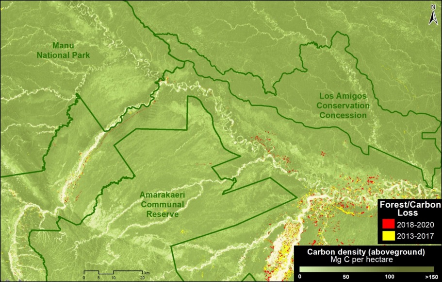
Zoom E shows how a group of protected areas (Manu National Park and Amarakaeri Communal Reserve) and the country’s first Conservation Concession (Los Amigos), is effectively safeguarding over 210 million metric tons of carbon in the southern Peruvian Amazon.
Methodology
This report combined two major datasets: 1) aboveground carbon from Asner et al 2014 and 2) annual forest loss identified by the Peruvian Environment Ministry’s National Forest Conservation Program (Geobosques) from the years 2013 to 2020.
The aboveground carbon data served as a baseline for 2013, and then we subsequently extracted the carbon data from the areas of forest loss from 2013-2020.
This process allowed us to obtain the carbon density (per hectare) in relation to the area of forest loss and then to estimate the total aboveground carbon stocks lost between 2013 and 2020.
The forest loss data values include some natural forest loss. Overall, however, they should be considered underestimates because they do not include forest degradation (for example, selective logging).
References
Asner GP et al (2014). The High-Resolution Carbon Geography of Perú. Carnegie Institution for Science.
EPA. Greenhouse Gas Equivalencies Calculator. https://www.epa.gov/energy/greenhouse-gas-equivalencies-calculator
Acknowledgements
We thank A. Folhadella, M. Hyde, ME Gutierrez, and G. Palacios for their helpful comments on this report.
This work was supported by NORAD (Norwegian Agency for Development Cooperation) and ICFC (International Conservation Fund of Canada).

Citation
Finer M, Mamani N (2021). Carbon loss & protection in the Peruvian Amazon. MAAP: 148.
