MAAP #161: Soy Deforestation in the Brazilian Amazon
July 18, 2022
The Amazon Soy Moratorium has often been credited with significantly reducing soy-related deforestation in the Amazon over the past 15 years.
The Moratorium is a voluntary zero-deforestation agreement in which traders agree not to purchase soy grown on land cleared after 2008.
However, increasing soybean prices may be driving a resurgence of the problem of direct soy deforestation. That is, direct conversion of primary deforestation to soy plantation without passing an initial period as cattle pasture.
A recent report by Global Forest Watch estimated the direct soy deforestation of 29,000 hectares in the Brazilian Amazon in 2019 (Schneider et al 2021).
Here, we report the additional direct soy deforestation of at least 42,000 hectares in the Brazilian Amazon since 2020. All of these areas occurred in the state of Mato Grosso, located on the southeast edge of the Amazon.
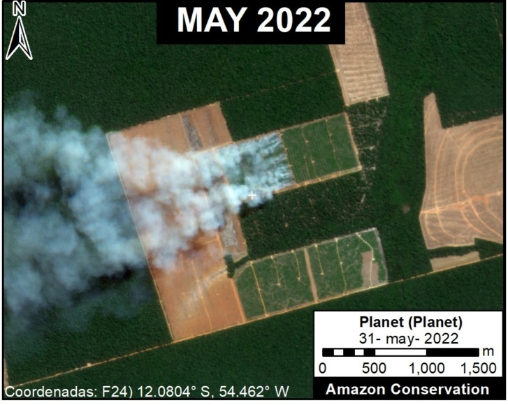
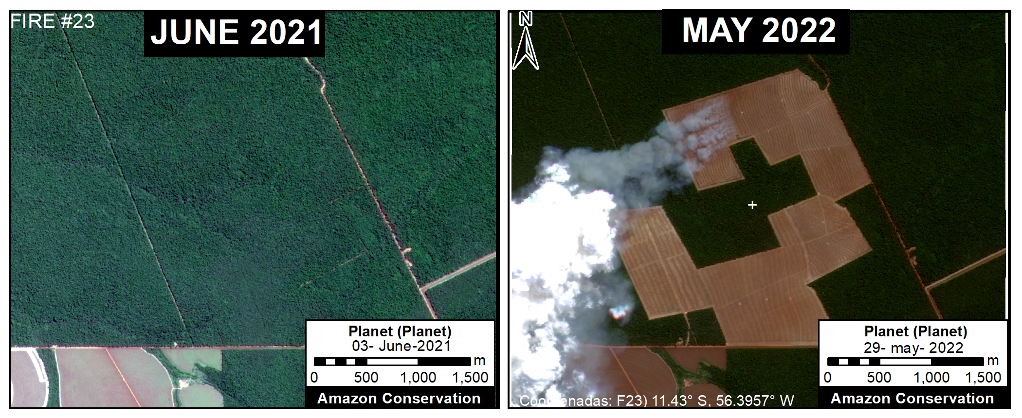
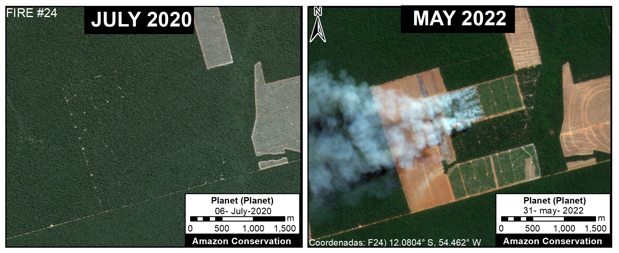
We detected all of these soy plantations based on recent major fire activity (84 major fires), in which the recently deforested area was burned in preparation for the upcoming planting season (see Methodology below for more details).
Below, we show a base map of these recently deforested and then burned areas in the Mato Grosso state of the Brazilian Amazon followed by a series of examples from the satellite imagery.
Base Map – Recent Soy Deforestation in Brazilian Amazon
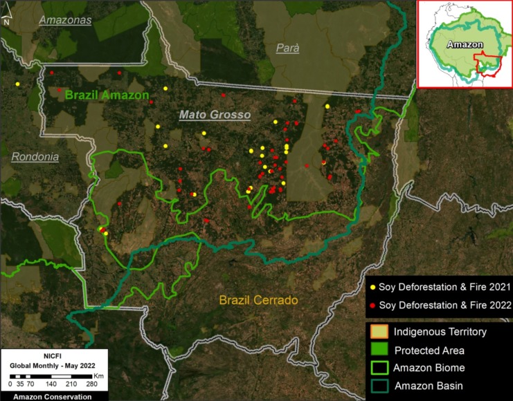
The Base Map below shows the areas, indicated by red dots, of recent direct deforestation for new soy plantations that we detected by monitoring major fire activity in 2022.
Between May 2021 and June 2022, we detected 84 major fires that corresponded to burning areas recently deforested for new soy plantations. These 84 areas, all of which occurred in the state of Mato Grosso, cover an area of 42,000 hectares.
Our geographic focus was the Brazilian Amazon biome in the state of Mato Grosso, as covered by the Amazon Soy Moratorium. For example, we also documented extensive direct soy deforestation and fire in the Bolivian Amazon (Santa Cruz department), but we did not include that information here.
Examples of Deforestation & Fire for New Soy Plantations
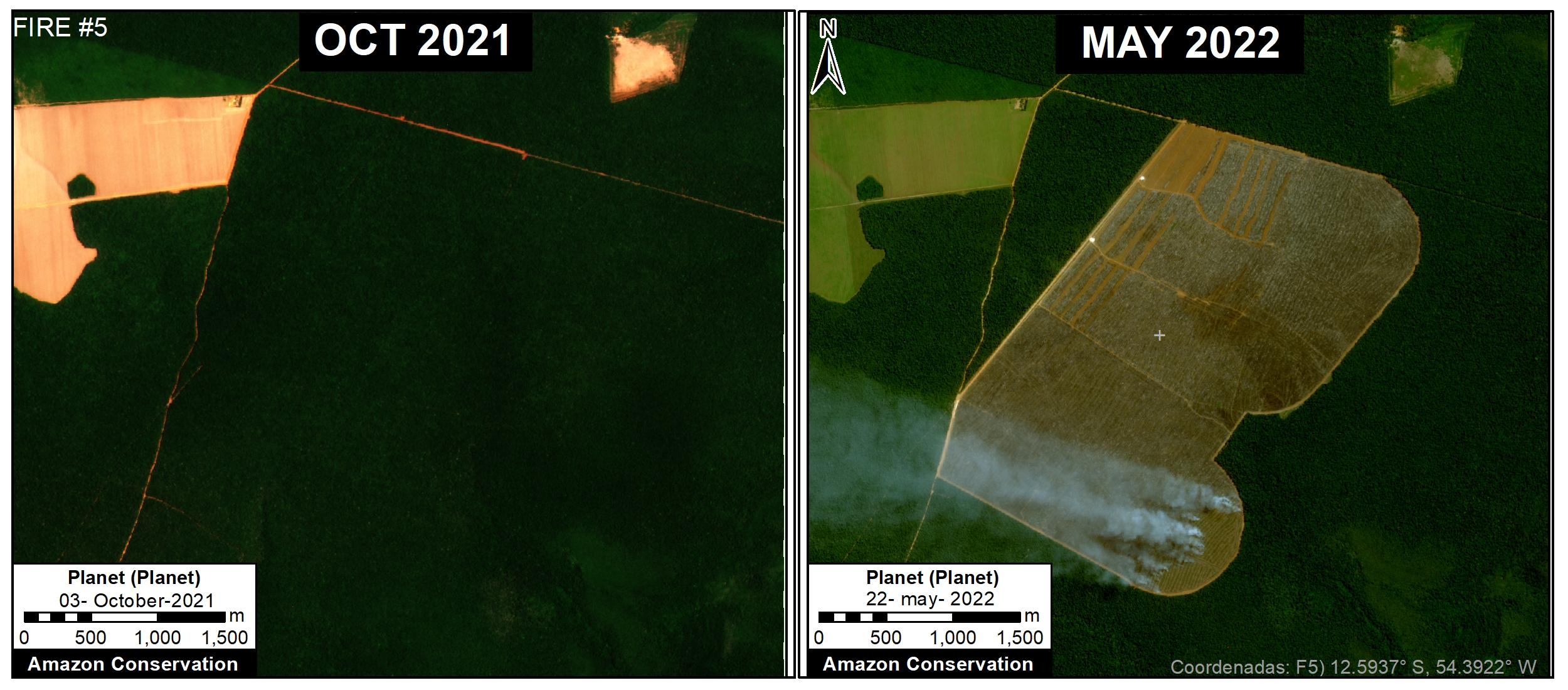
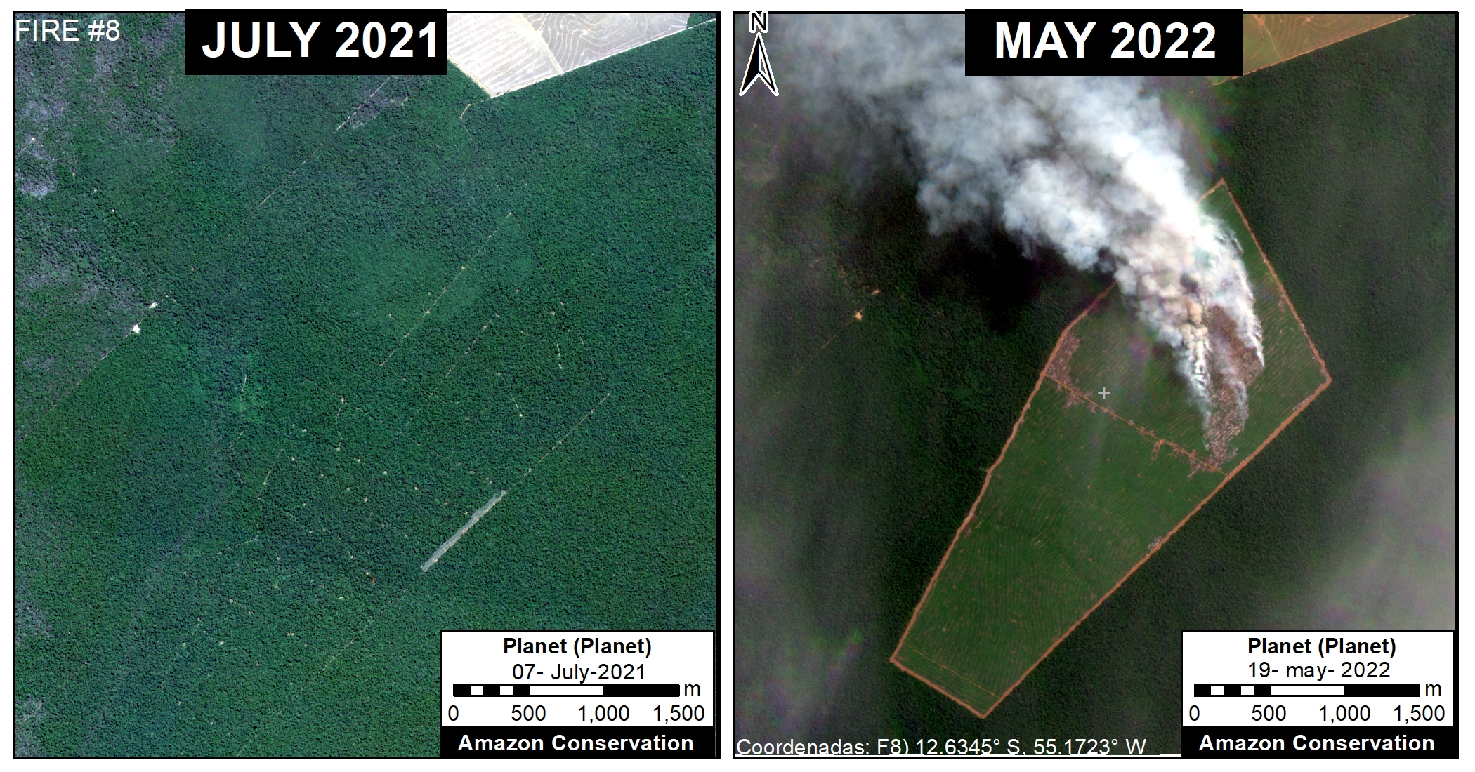
As noted above, we detected the direct deforestation for new soy plantations by monitoring major fire activity in 2022. It is assumed that fires are preparing the recently deforested area for upcoming soy planting.
Methodology
We first tracked major fires in 2021 and 2022 using our novel real-time fire monitoring app. See MAAP #118 for more background information about the app and general methodology for detecting major fires based on aerosol emissions. The first major fires were detected in May of each year (2021 and 2022) and we continued collecting data on a daily basis through early July of each year. We monitored fires across the entire Amazon, but this report focuses on Brazil.
For all major fires detected with the app, we confirmed them with high-resolution satellite imagery from Planet. This confirmation was accomplished by visualizing either smoke plumes the day of the fire or burned areas in subsequent days after the fire.
All confirmed fires were assigned a category based on likely direct fire type or driver. These categories include 1) burning area recently deforested for new soy plantation, burning area recently deforested for new cattle pasture, and burning grasslands embedded in the larger rainforest matrix. On rarer occasions, one of these fire types may escape into the surrounding forest, making it an actual forest fire.
Specifically, the soy-related fires were defined as those burning recently deforested areas (that is, areas cleared since 2020) that had a distinctive linear pattern seemingly designed for organized crop agriculture. Most of the newly identified soy areas were also adjacent to existing soy plantations. In other words, the soy deforestation and fire pattern were visually quite distinct from cattle-related and grassland fires. Local experts have informed us that the fires are likely prepping the recently deforested area for the upcoming soy planting season. For all determined direct soy-related fires, we estimated the burned area using the spatial measurement tools in Planet Explorer and entered it into a database. We noted that in July of both years, the fires shifted away from soy and more towards cattle areas.
References
Martina Schneider, Liz Goldman, Mikaela Weisse, Luiz Amaral and Luiz Calado (2021) The Commodity Report: Soy Production’s Impact on Forests in South America. Link: https://www.globalforestwatch.org/blog/commodities/soy-production-forests-south-america/
X.-P. Song, M.C. Hansen, P. Potapov, et al (2021). Massive soybean expansion in South America since 2000 and implications for conservation. Nature Sustainability. Link: https://www.nature.com/articles/s41893-021-00729-z
Acknowledgements
We thank V. Silgueiro and R. Carvalho from the organization Instituto Centro de Vida (ICV) for helpful information and comments related to this report.
Citation
Finer M, Ariñez A (2022) Soy Deforestation in the Brazilian Amazon. MAAP: #161.
