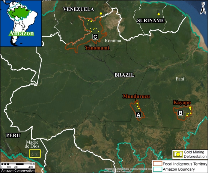
Base Map. Major gold mining deforestation zones across the Amazon. Data: MAAP.
We present the second part of our series on Amazon gold mining, with a focus on the Brazil*
Specifically, we focus on mining in indigenous territories in the Brazilian Amazon.
Extractive activities, such as gold mining, are constitutionally not permitted on indigenous lands, but the Bolsonaro administration is advancing a bill (PL 191) that would reverse this.
The Base Map indicates three Brazilian indigenous territories where we identified recent major gold mining deforestation:
- Munduruku (Pará)
- Kayapó (Pará)
- Yanomami (Roraima)
We documented the gold mining deforestation of 10,245 hectares (25,315 acres) across all three indigenous territories over the past three years (2017 – 2019). That is the equivalent of 14,000 soccer fields.
Below, see more detailed data, including a series of satellite GIFs of the recent gold mining deforestation in each territory.
*Part 1 looked at the Peruvian Amazon (see MAAP #115). For information on Suriname, see this report from Amazon Conservation Team. For all other countries see this resource from RAISG.
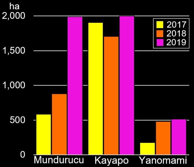
Graph 1. Gold mining deforestation in three indigenous territories in the Brazilian Amazon.
Mining Deforestation Increasing
In 2019, all three territories experienced an increase in gold mining deforestation.
In Munduruku Territory, we documented the loss of 3,456 hectares due to mining activity between 2017 and 2019. Note the major spike in 2019, where mining deforestation reached 2,000 hectares.
In Kayapó Territory, we documented the loss of 5,614 hectares between 2017 and 2019. Note that mining deforestation also reached 2,000 hectares in 2019.
In Yanomami Territory, we documented the loss of 1,174 hectares between 2017 and 2019. Note that mining deforestation reached 500 hectares in 2019.
Overall, 44% (4,500 hectares) of the gold mining deforestation occurred in 2019, indicating an increasing trend.
A. Munduruku (Pará)
The GIF below shows an example of gold mining deforestation in Munduruku Territory between 2017 and 2019.
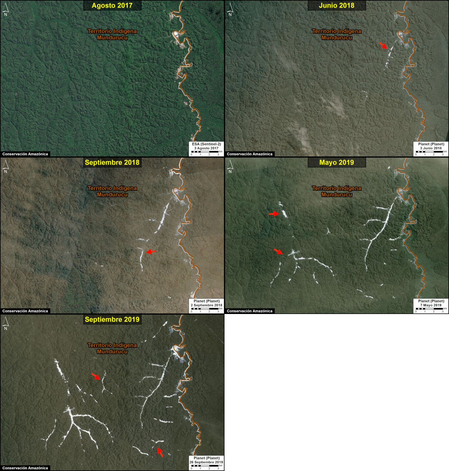
Gold mining deforestation in Munduruku Territory between 2017 and 2019. Data: Planet, MAAP.
B. Kayapó (Pará)
The GIF below shows an example of gold mining deforestation in Kayapó Territory between 2017 and 2019.
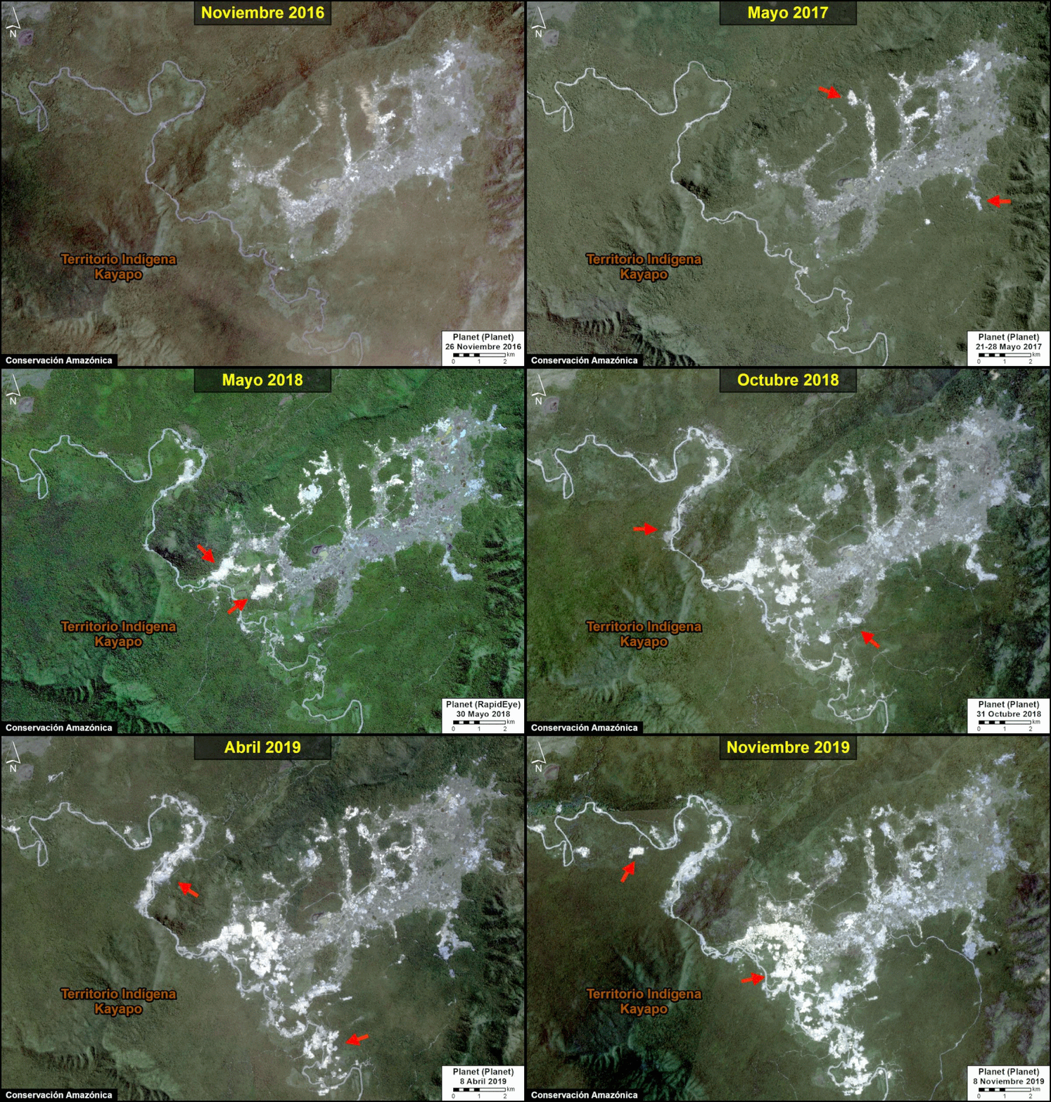
Gold mining deforestation in Kayapó Territory between 2017 and 2019. Data: Planet, MAAP.
C. Yanomami (Roraima)
The GIF below shows an example of gold mining deforestation in Yanomami Territory between 2017 and 2019.
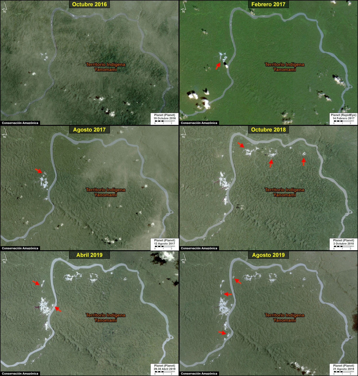
Gold mining deforestation in Yanomami Territory between 2017 and 2019. Data: Planet, MAAP.
Annex: Detailed Territory Maps
Below see detailed gold mining deforestation maps for all three Brazilian indigenous territories detailed in this report. Click each image to enlarge.
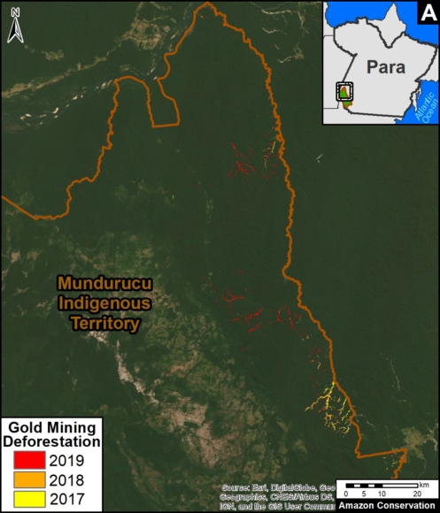
Gold mining deforestation in Munduruku Territory between 2017 and 2019. Data: MAAP. Click to enlarge.
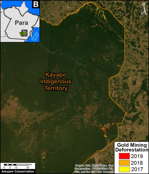
Gold mining deforestation in Kayapó Territory between 2017 and 2019. Data: MAAP. Click to enlarge.
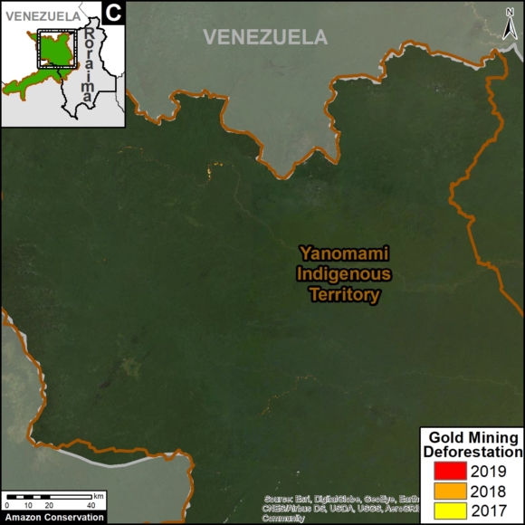
Gold mining deforestation in Yanomami Territory between 2017 and 2019. Data: MAAP. Click to enlarge.
Acknowledgements
We thank S. Novoa (ACCA), V. Guidotti de Faria (Imaflora), and G. Palacios for helpful comments to earlier versions of this report.
This work was supported by the following major funders: Global Forest Watch Small Grants Fund (WRI), Norwegian Agency for Development Cooperation (NORAD), International Conservation Fund of Canada (ICFC), Metabolic Studio, and Erol Foundation.
Citation
Finer M, Mamani N (2020) Amazon Gold Mining, part 2: Brazil. MAAP: 116.
