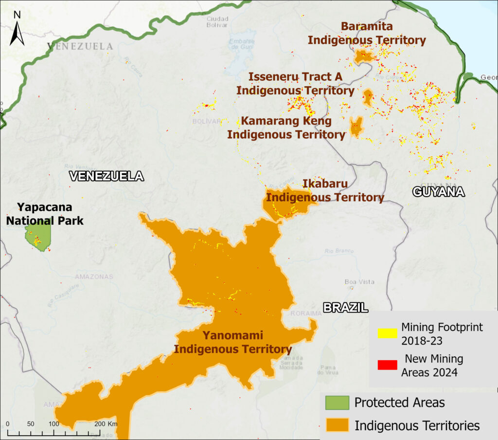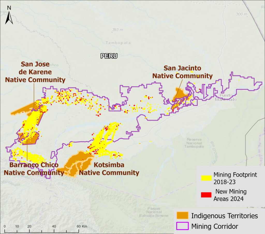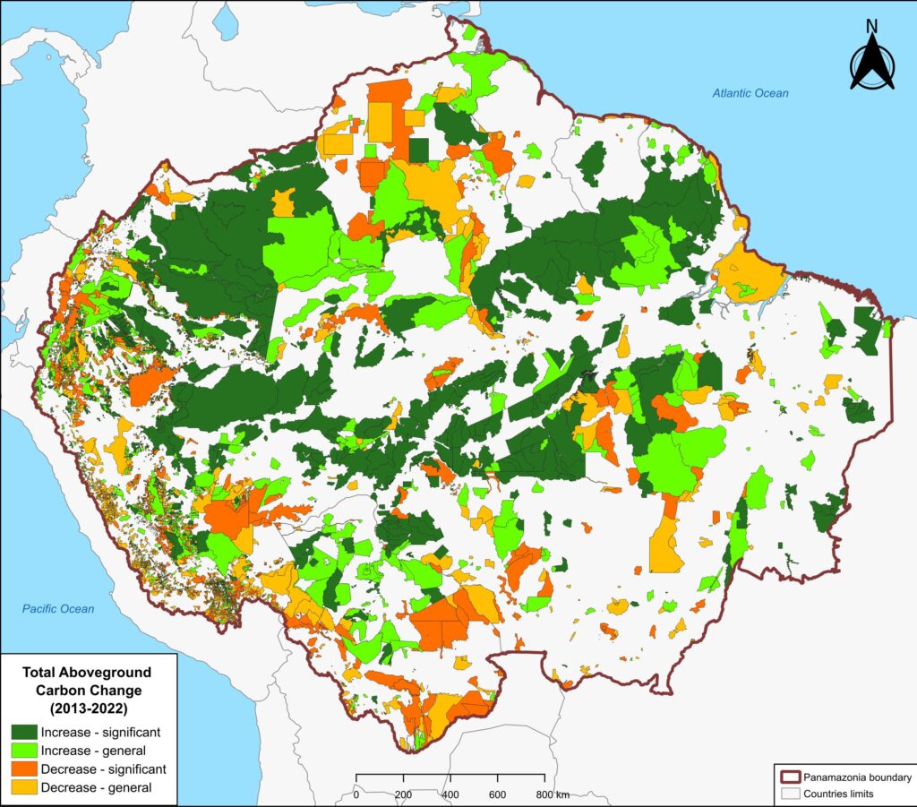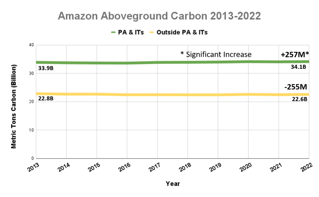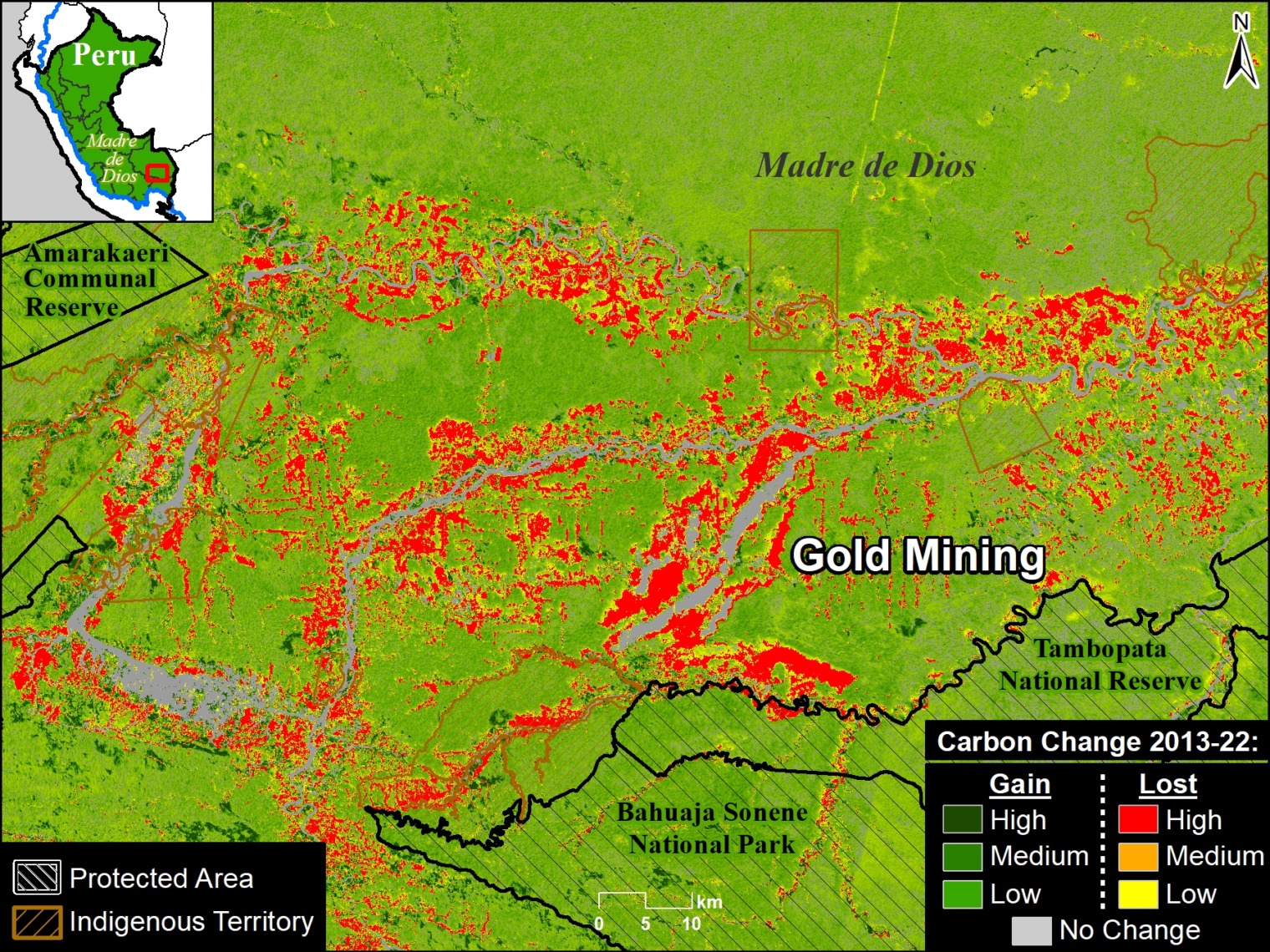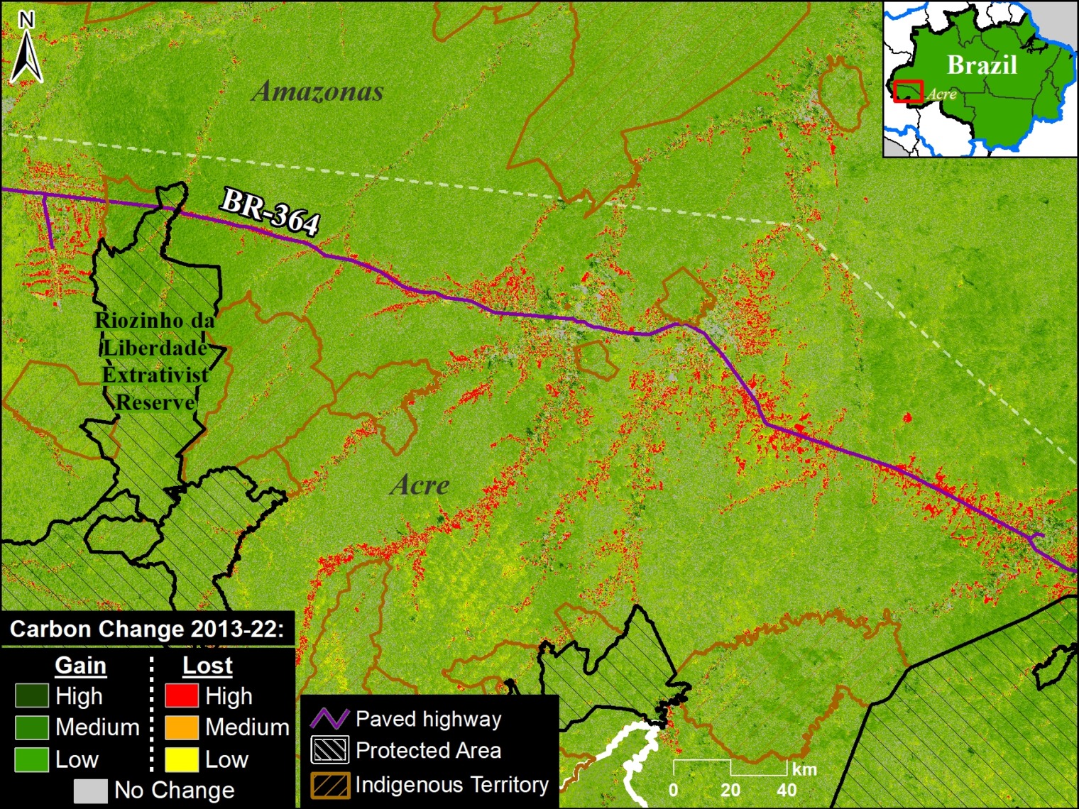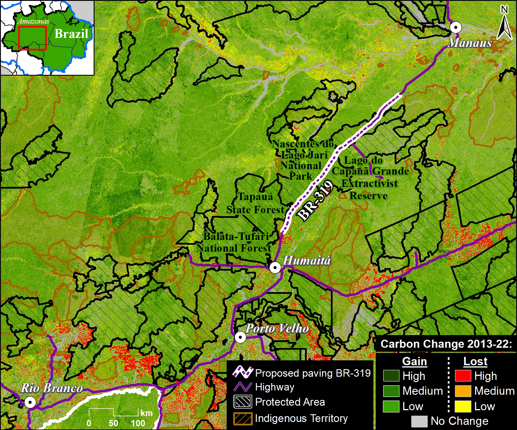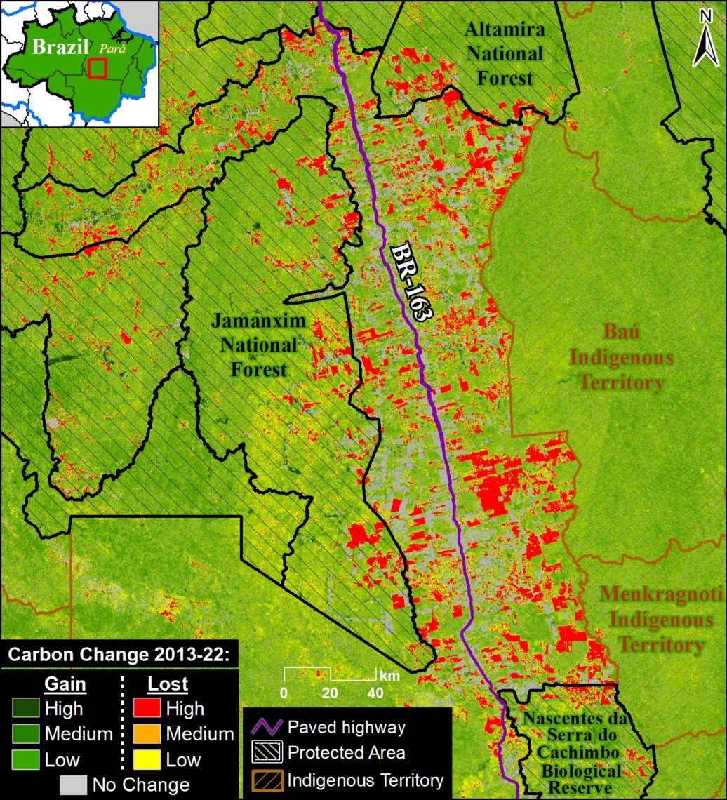
MAAP #217: Carbon across the Amazon (part 2): Peak Carbon Areas

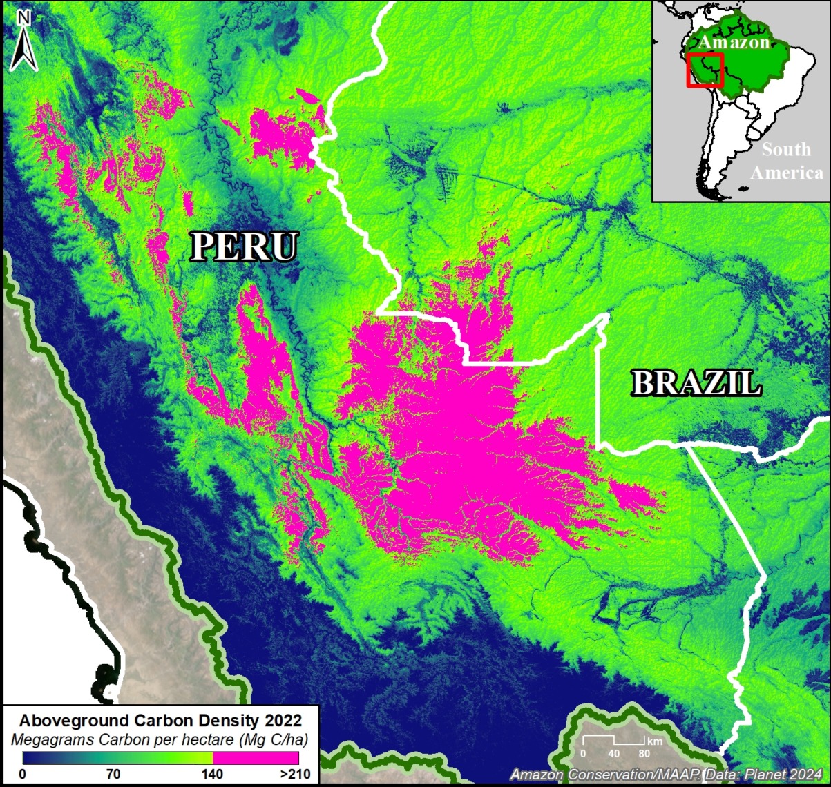
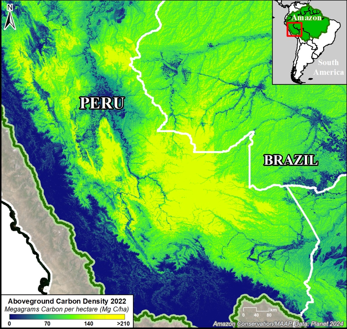
Figure 1. Example of peak carbon areas in southern Peru and adjacent western Brazil. Data: Planet.

In part 1 of this series (MAAP #215), we introduced a critical new resource (Planet Forest Carbon Diligence) that provides wall-to-wall estimates for aboveground carbon density at an unprecedented 30-meter resolution. This data uniquely merges machine learning, satellite imagery, airborne lasers, and a global biomass dataset from GEDI, a NASA mission.4

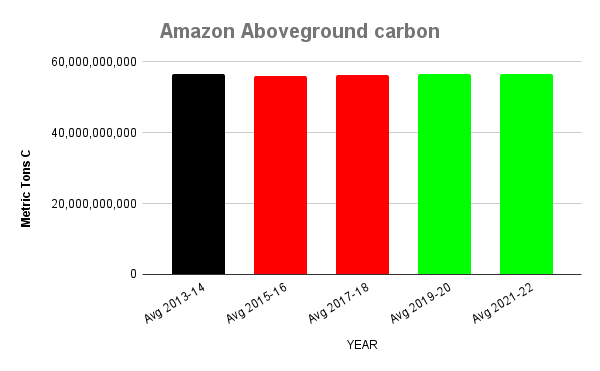
In that report, we showed that the Amazon contains 56.8 billion metric tons of aboveground carbon (as of 2022), and described key patterns across all nine countries of the Amazon biome over the past decade.

Here, in part 2, we focus on the peak carbon areas of the Amazon that are home to the highest aboveground carbon levels.

These peak carbon areas correspond to the upper one-third of aboveground carbon density levels (>140 metric tons per hectare).1

They likely have experienced minimal degradation (such as selective logging, fire, and edge/fragmentation effects)2 and are thus a good proxy for high-integrity forests.

Figure 1 shows an important example of peak carbon areas in southern Peru and adjacent western Brazil.

The peak carbon areas are often found in the remote primary forests of protected areas and Indigenous territories, but some are located in forestry concessions (specifically, logging concessions) or undesignated lands (also referred to as undesignated public forests).

Our goal in this report is to leverage unprecedented aboveground carbon data to reinforce the importance of these designated areas and draw attention to the remaining undesignated lands.

For example, peak carbon areas would be excellent candidates for the High Integrity Forest (HIFOR) initiative, a new financing instrument that uniquely focuses on maintaining intact tropical forests.3 HIFOR rewards the climate services that intact tropical forests provide, including ongoing net carbon removal from the atmosphere, and complements existing instruments to reduce emissions from deforestation and degradation (REDD+) by focusing on tropical forests that are largely undegraded.

Below, we detail the major findings and then zoom in on the peak carbon areas in the northeast and southwest Amazon.

Peak Carbon Areas in the Amazon   

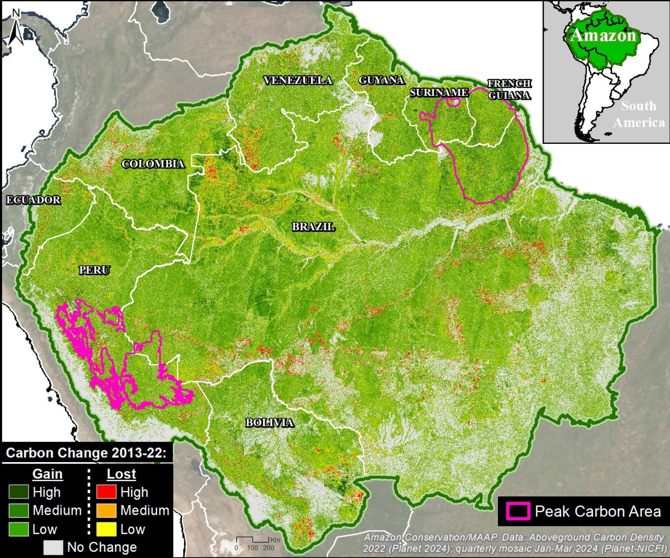
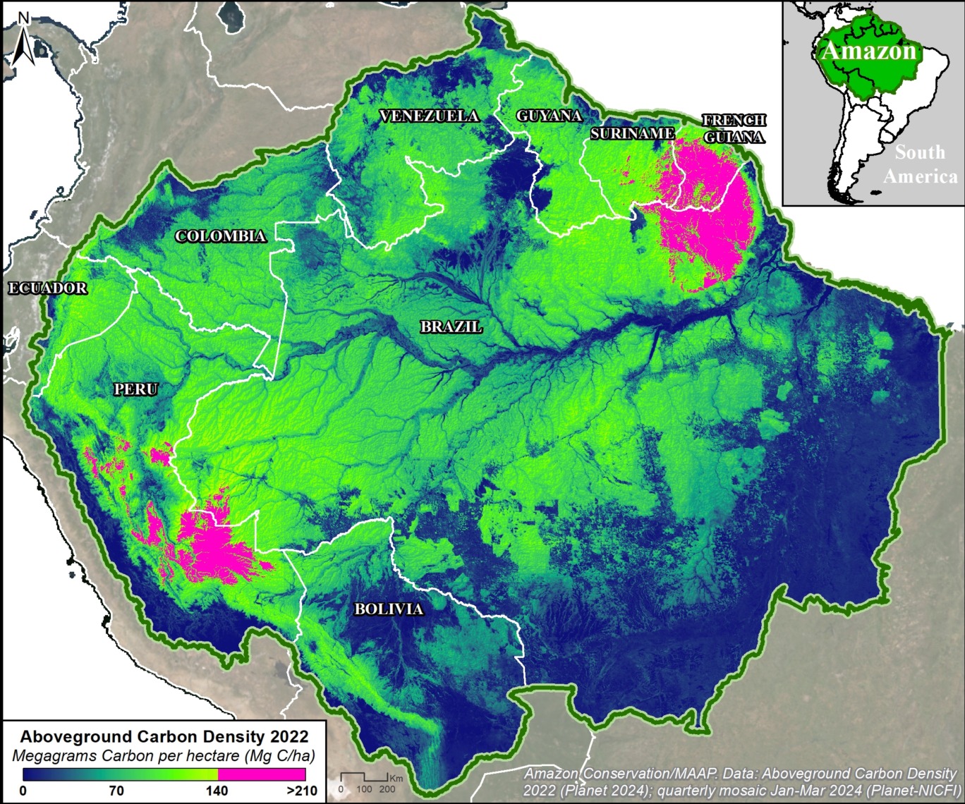
The Base Map below illustrates our major findings.

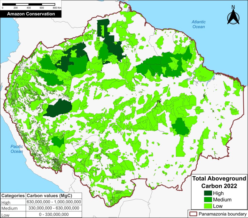
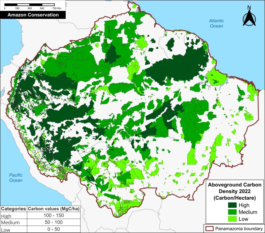
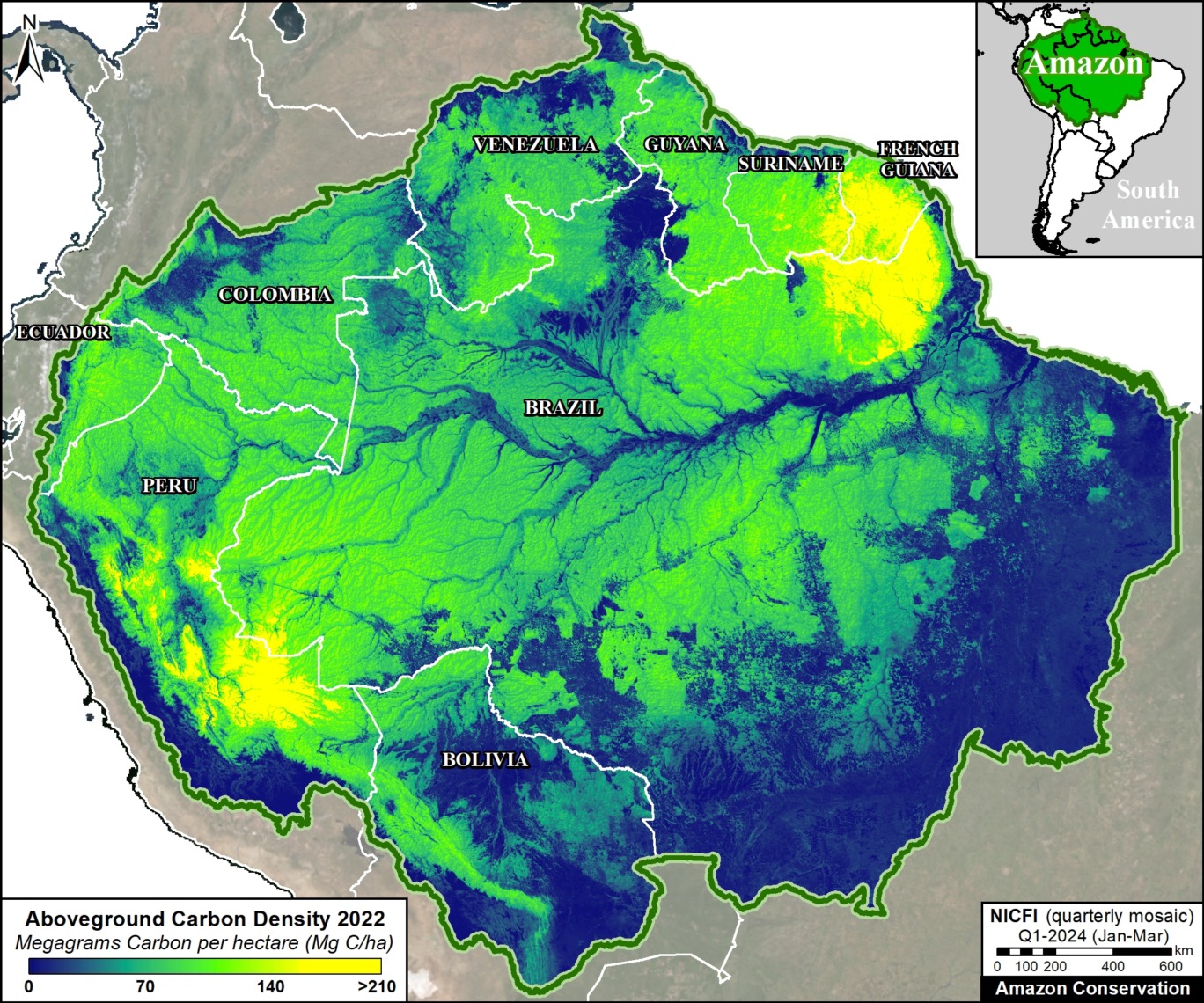
The peak carbon areas (>140 metric tons per hectare; indicated in pink) are concentrated in the southwest and northeast Amazon, covering 27.8 million hectares (11 million ha in the southwest and 16.8 million ha in the northeast).
k

Base Map. Planet Forest Carbon Diligence across the Amazon biome for the year 2022. Data: Planet.

In the southwest Amazon, peak carbon levels are found in southern & central Peru, and adjacent western Brazil.

In the northeast Amazon, peak carbon levels are found in northeast Brazil, much of French Guiana, and parts of Suriname.

By country, Brazil and Peru have the largest area of peak carbon (10.9 million and 10.1 million hectares respectively), followed by French Guiana (4.7 million ha), and Suriname (2.1 million ha).

Protected areas and Indigenous territories cover much (61%) of the peak carbon area (16.9 million hectares).

The remaining 39% remains unprotected, and arguably threatened, in undesignated lands (9.4 million hectares) and forestry concessions (1.5 million ha), respectively.

In addition, high carbon areas (>70 metric tons per hectare; indicated by the greenish-yellow coloration in the Base Map) are found in all nine countries of the Amazon biome, notably Colombia, Ecuador, Bolivia, Venezuela, and Guyana.

Southwest Amazon

­Southern Peru

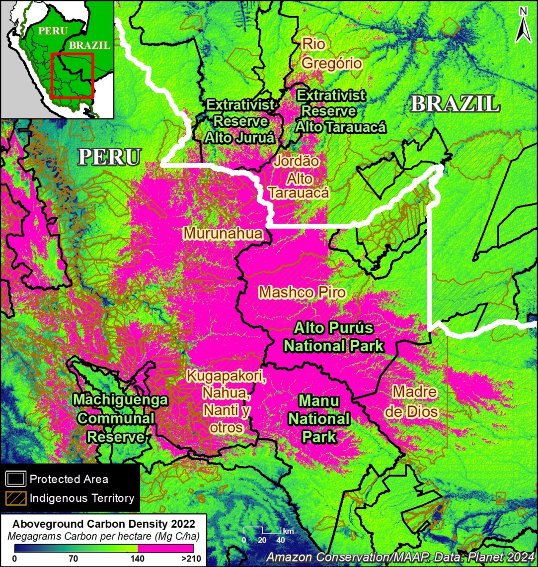
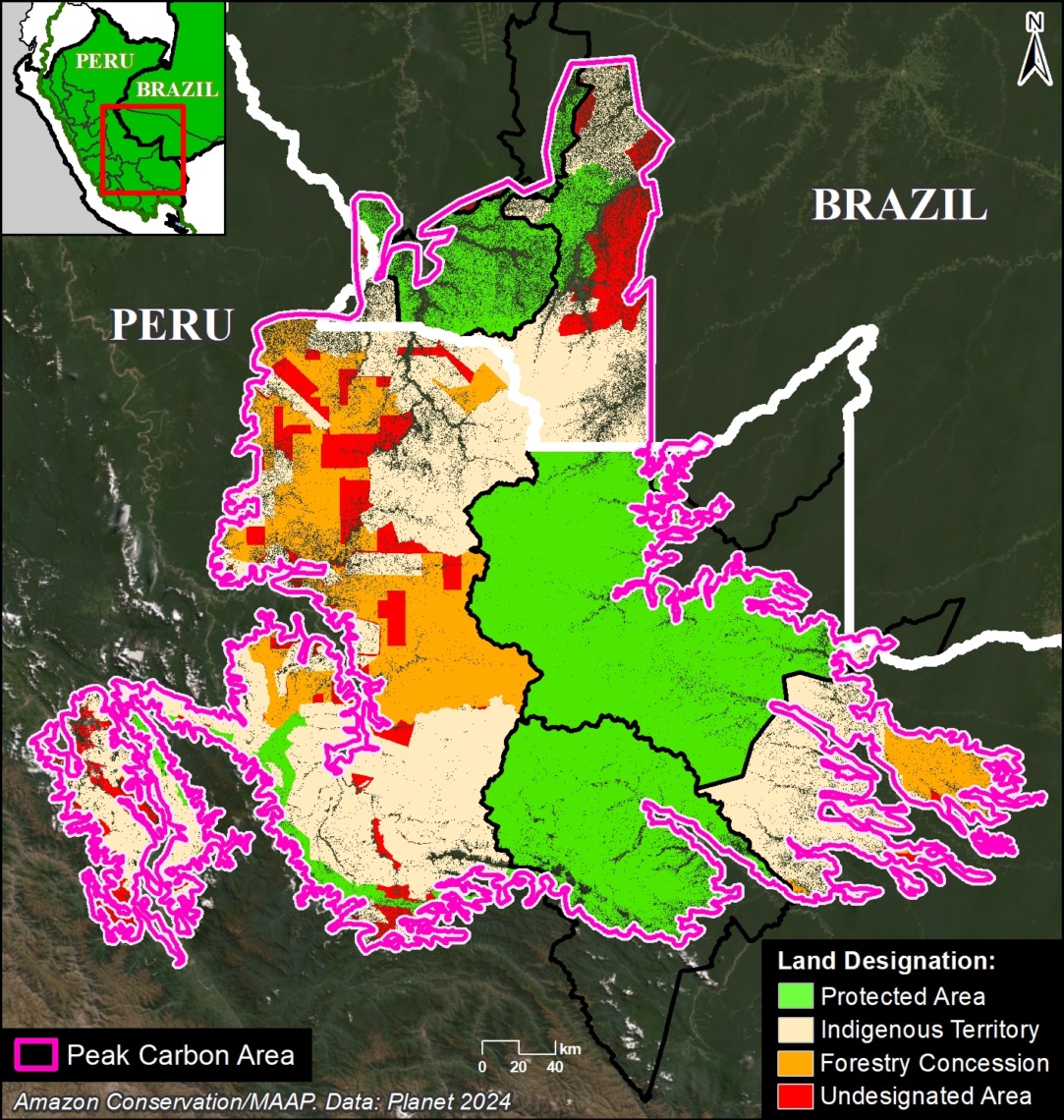
Figure 2a. Peak carbon area in the southern Peruvian Amazon. Data: Planet, SERNANP, RAISG.

Figure 2a zooms in on the peak carbon area covering 7.9 million hectares in southern Peru (regions of Madre de Dios, Cusco, and Ucayali) and adjacent southwest Brazil (Acre).

Several protected areas (such as Manu and Alto Purús National Parks, and Machiguenga Communal Reserve) anchor this area.

It is also home to numerous Indigenous territories (such as Mashco Piro, Madre de Dios, and Kugapakori, Nahua, Nanti & Others Indigenous Reserves).


Figure 2b highlights the major land designations within the peak carbon area of southern Peru.

Figure 2b. Peak carbon areas (outlined in pink), categorized by land designation in southern Peru and adjacent western Brazil. Data: Planet, NICFI, SERNANP, SERFOR, RAISG.

Protected areas and Indigenous territories cover 77% of this area (green and brown, respectively).

The remaining 23% could be considered threatened, as they are located in forestry concessions or undesignated lands (orange and red, respectively). Thus, these areas are ideal candidates for increased protection to maintain their peak carbon levels.


Central Peru

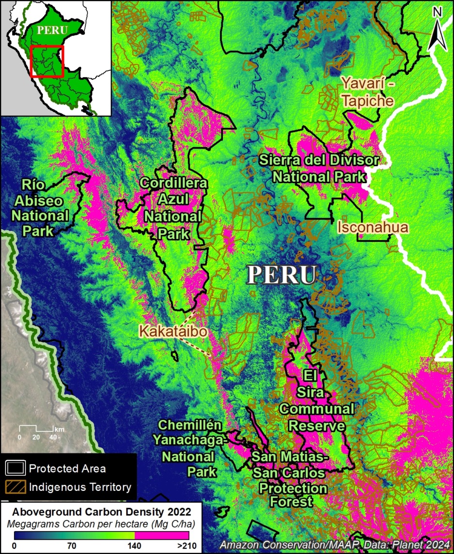
Figure 3a. Peak carbon area in the central Peruvian Amazon. Data: Planet, SERNANP, RAISG.

Figure 3a zooms in on the peak carbon area in the central Peruvian Amazon, which covers 3.1 million hectares in the regions of Ucayali, Loreto, Huánuco, Pasco, and San Martin.

Several protected areas (including Sierra del Divisor, Cordillera Azul, Rio Abiseo, and Yanachaga–Chemillén National Parks, and El Sira Communal Reserve) anchor this area.

It is also home to numerous Indigenous territories (such as Kakataibo, Isconahua, and Yavarí Tapiche Indigenous Reserves).


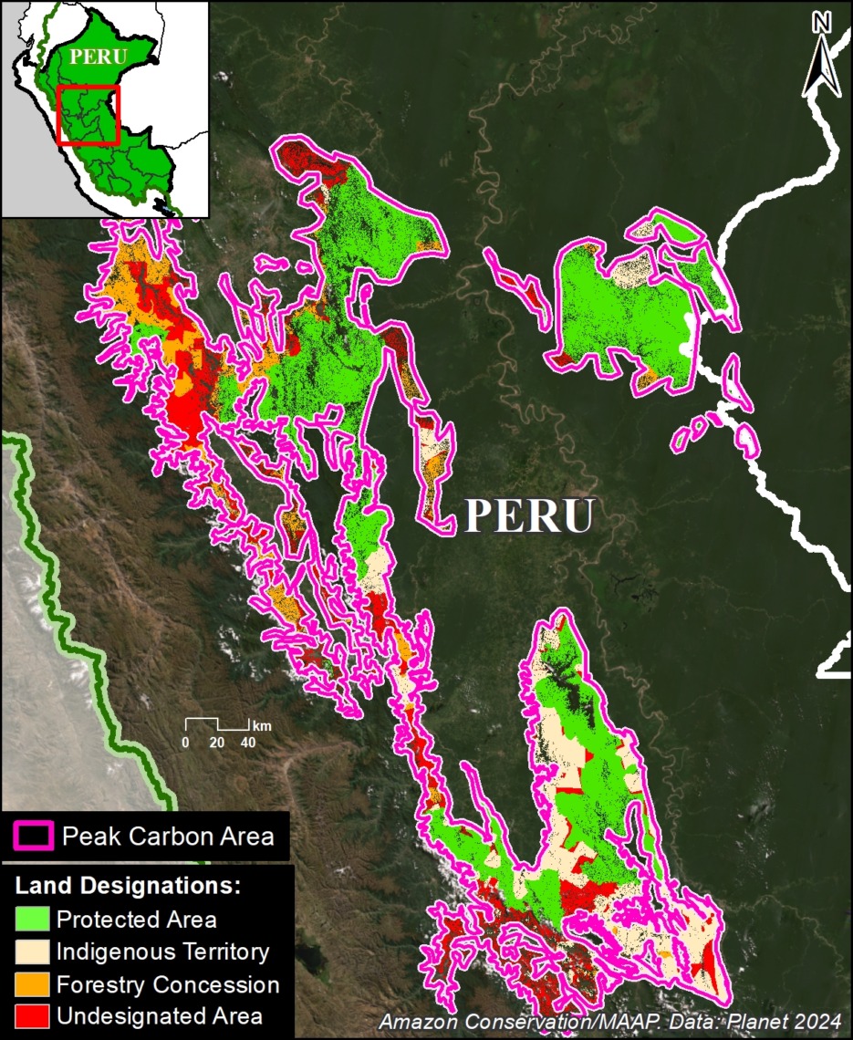
Figure 3b. Peak carbon areas (outlined in pink), categorized by land designation in central Peru. Data: Planet, NICFI, SERNANP, SERFOR, RAISG.

Figure 3b highlights the major land designations within the peak carbon area of central Peru.

Protected areas and Indigenous territories cover 69% of this area (green and brown, respectively).

The remaining 31% could be considered threatened, as they are located in forestry concessions or undesignated lands (orange and red, respectively), and are ideal candidates for increased protection.


Northeast Amazon

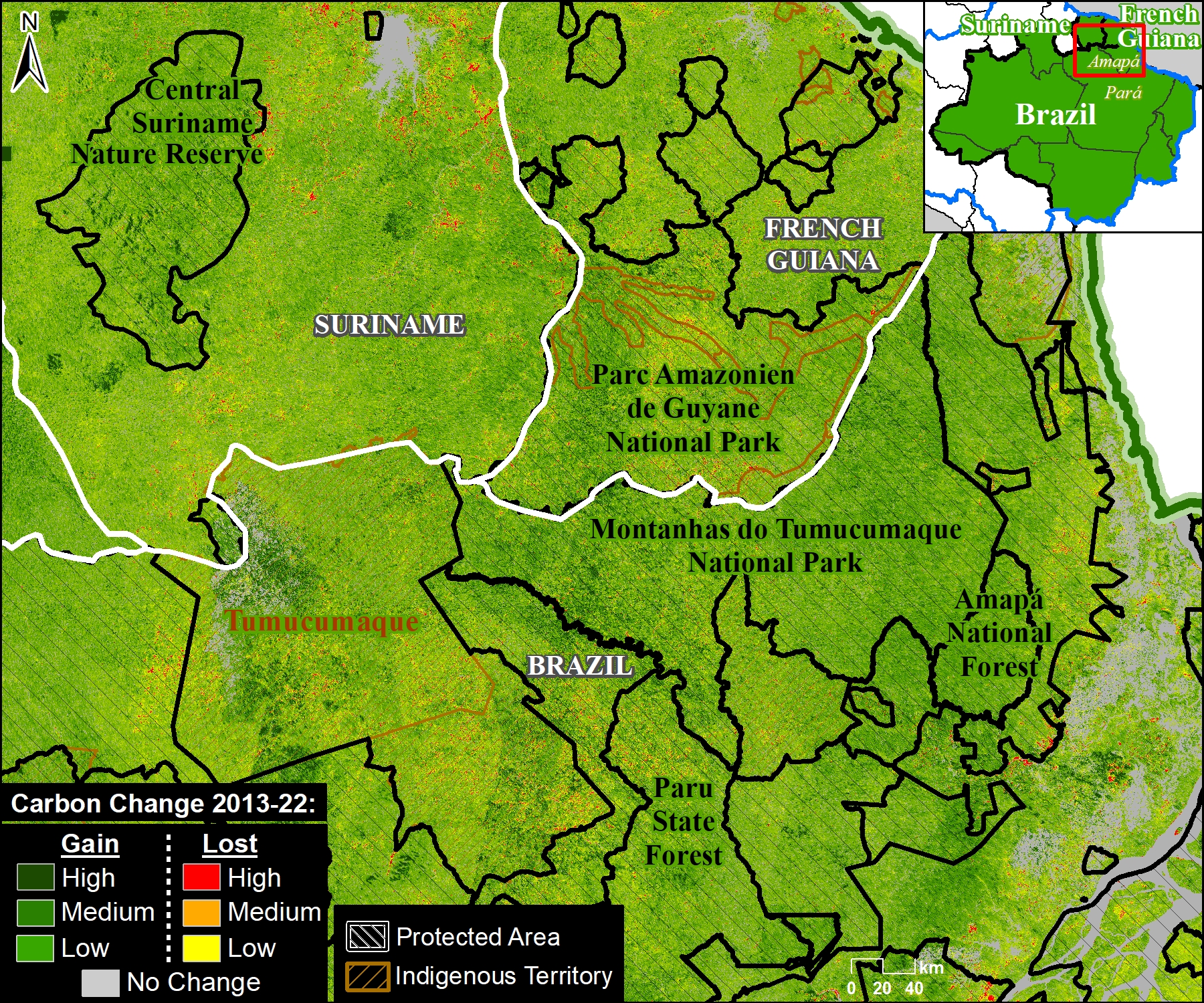
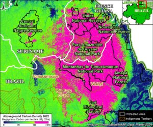
Figure 4a. Peak carbon area in the tri-border region of the northeast Amazon. Data: Planet, RAISG.

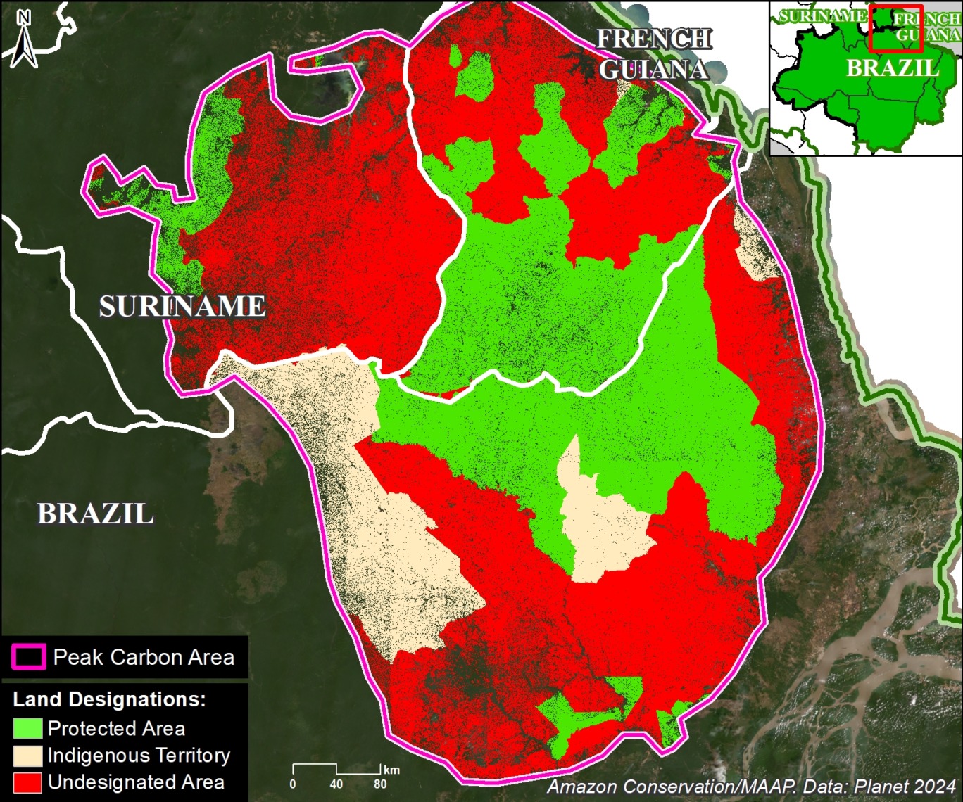
Figure 4a zooms in on the peak carbon area in the tri-border region of the northeast Amazon, which covers 16.8 million hectares in northern Brazil, French Guiana, and Suriname.

Several protected areas (including Montanhas do Tumucumaque National Park in northeast Brazil, Amazonien de Guyane National Park in French Guiana, and Central Suriname Nature Reserve) anchor this area.

It is also home to numerous Indigenous territories (such as Tumucumaque, Rio Paru de Este, and Wayãpi in northeast Brazil).


Figure 4b. Peak carbon areas (outlined in pink), categorized by land designation in northeast Amazon. Data: Planet, NICFI, RAISG.

Figure 4b highlights the major land designations within the peak carbon area of the northeast Amazon.

Protected areas and Indigenous territories cover just over half (51%) of this area (green and brown, respectively).

The remaining 49% could be considered threatened, as they are located in undesignated lands, and are ideal candidates for increased protection.


Notes

1 We selected this value (upper 33%) to capture the highest aboveground carbon areas and include a range of high carbon areas. Additional analyses could target different values, such as the highest 10% or 20% of aboveground carbon.

2  A recent paper documented a strong relationship between selective logging and aboveground carbon loss (Csillik et al. 2024, PNAS). The link between forest edges and carbon is presented in Silva Junior et al, Science Advances.

3 High Integrity Forest (HIFOR) units are a new tradable asset that recognizes and rewards the essential climate services and biodiversity conservation that intact tropical forests provide, including ongoing net removal of CO2 from the atmosphere. For more information see https://www.wcs.org/our-work/climate-change/forests-and-climate-change/hifor

4 For more information, see the “What is Forest Carbon Diligence?” section in this recent blog from Planet.

Citation

Finer M, Mamani N, Anderson C, Rosenthal A (2024) Carbon across the Amazon (part 2): Peak Carbon Areas. MAAP #217.

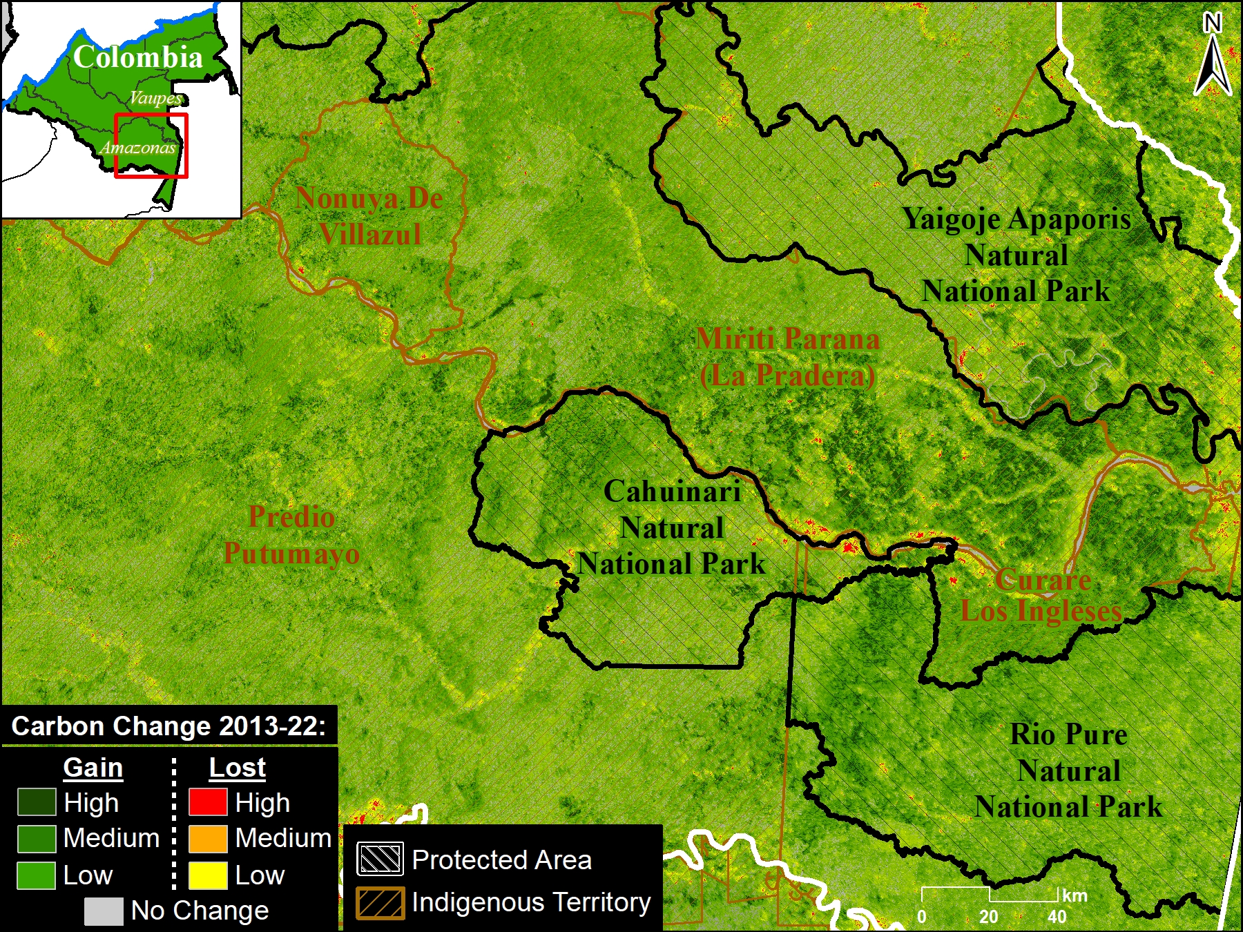
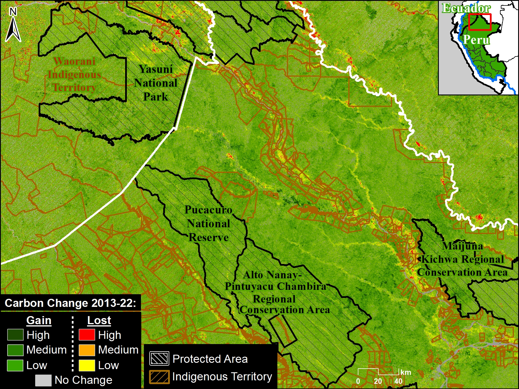
MAAP #215: Unprecedented Look at Carbon across the Amazon (part 1)

Figure 1. Example of Planet Forest Carbon Diligence, focused on southern Peru and adjacent western Brazil.

The Amazon biome has long been one of the world’s largest carbon sinks, helping stabilize the global climate.

Precisely estimating this carbon, however, has been a challenge. Fortunately, new satellite-based technologies are providing major advances, most notably NASA’s GEDI mission (see MAAP #213) and, most recently, Planet Forest Carbon Diligence.1

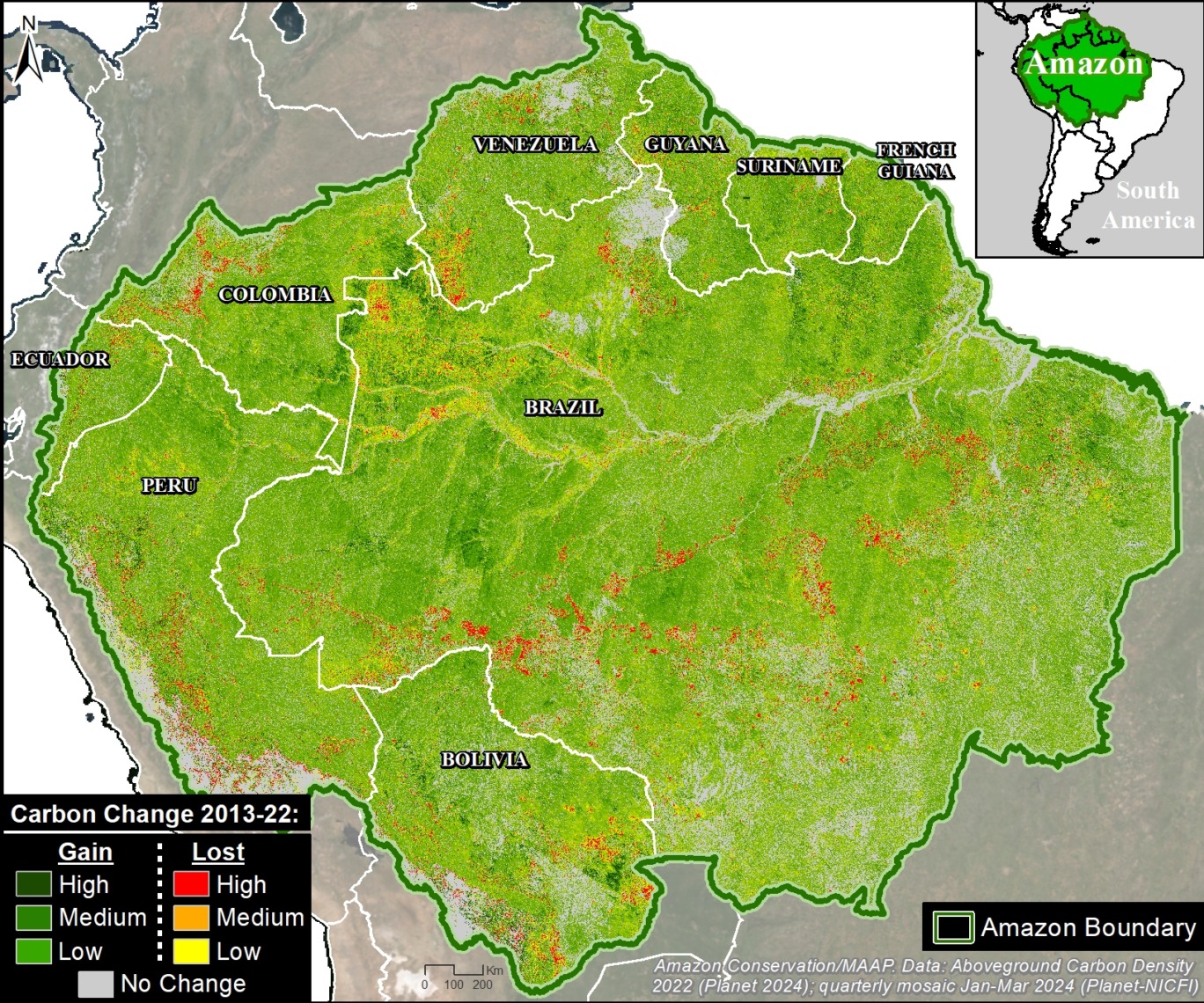
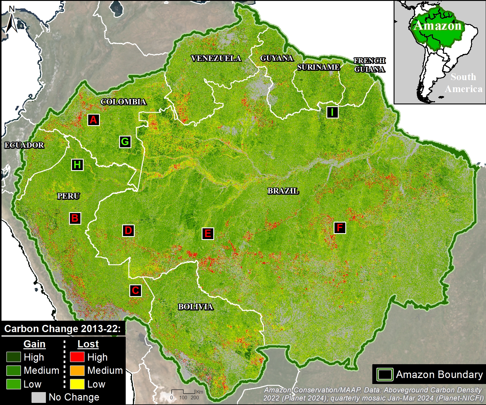
Here, we focus on the latter, analyzing Planet’s cutting-edge new dataset, featuring a 10-year historical time series (2013 – 2022) with wall-to-wall estimates for aboveground carbon density at 30-meter resolution.

As a result, we can produce high-resolution aboveground carbon maps and estimates for anywhere and everywhere across the vast Amazon (see Figure 1).

Through a generous sharing agreement with Planet, we have been granted access to this data across the entire Amazon biome for the analysis presented in the following three-part series:

  1. Estimate and illustrate total aboveground forest carbon across the Amazon biome in unprecedented detail (see results of this first report, below).
    j
  2. Highlight which parts of the Amazon are home to the highest aboveground carbon levels, including protected areas and Indigenous territories (see second report, MAAP #217).
    l
  3. Present emblematic deforestation cases that have resulted in the highest aboveground carbon emissions across the Amazon (see third report, MAAP #220).

Major Results

Carbon across the Amazon

Based on our analysis of Planet Forest Carbon Diligence, we estimate that the Amazon contained 56.8 billion metric tons of aboveground carbon, as of 2022 (see Base Map). Applying a standard root-to-shoot ratio conversion (26%), this estimate increases to 71.5 billion metric tons of above and belowground carbon. This total is equivalent to nearly two years of global carbon dioxide emissions at the peak 2022 level (37.15 billion metric tons).5

The peak carbon levels are largely concentrated in the southwest Amazon (southern Peru and adjacent western Brazil) and northeast Amazon (northeast Brazil, French Guiana, and Suriname).

Base Map. Planet Forest Carbon Diligence across the Amazon biome.

Total Carbon by Country

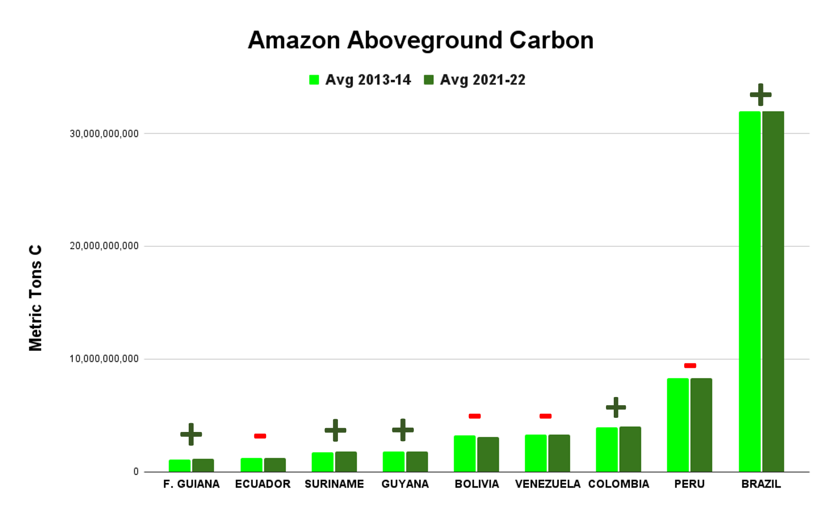
As shown in Graph 1, countries with the most aboveground carbon are 1) Brazil (57%; 32.1 billion metric tons), 2) Peru (15%; 8.3 billion metric tons), 3) Colombia (7%; 4 billion metric tons), 4) Venezuela (6%; 3.3 billion metric tons), and 5) Bolivia (6%; 3.2 billion metric tons). These countries are followed by Guyana (3%; 2 billion metric tons), Suriname (3%; 1.6 billion metric tons), Ecuador (2%; 1.2 billion metric tons), and French Guiana (2%; 1.1 billion metric tons).

Overall, we documented the total gain of 64.7 million metric tons of aboveground carbon across the Amazon during the ten years between 2013 and 2022.2 In other words, the Amazon is still functioning as a critical carbon sink.

The countries with the most aboveground carbon gain over the past ten years are 1) Brazil, 2) Colombia, 3) Suriname, 4) Guyana, and 5) French Guiana. Note that we show Brazil as a carbon sink (gain of 102.8 million metric tons), despite other recent studies showing it as a carbon source.3 Also note the important gains in aboveground carbon across several key High Forest cover, Low Deforestation (HFLD) countries, namely Colombia, Suriname, Guyana, and French Guiana.4

In contrast, the countries with the most aboveground carbon loss over the past ten years are 1) Bolivia, 2) Venezuela, 3) Peru, and 4) Ecuador.

Graph 1. Planet Forest Carbon Diligence data across the Amazon biome, comparing 2013-14 with 2021-22. Note that a “+” symbol indicates that the country gained aboveground carbon, while a “-“ symbol indicates that the country lost aboveground carbon.

Carbon Density by Country

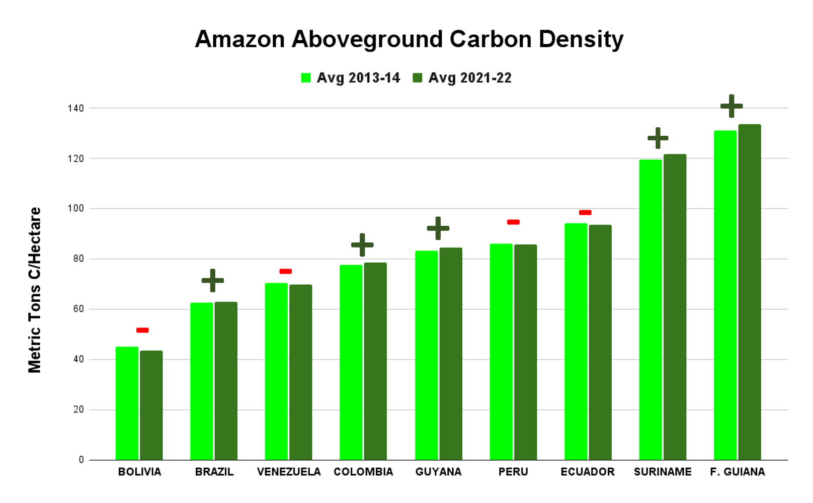
Standardizing for area, Graph 2 shows that countries with the highest aboveground carbon density (that is, aboveground carbon per hectare as of 2021-22) are located in the northeast Amazon: French Guiana (134 metric tons/hectare), Suriname (122 metric tons/hectare), and Guyana (85 metric tons/hectare). Ecuador is also high (94 metric tons/hectare).

Note that countries in the northeast Amazon (French Guiana, Suriname, and Guyana) have lower total aboveground carbon due to their smaller size (Graph 1), but high aboveground carbon density per hectare (Graph 2). This also applies to Ecuador.

Graph 2. Planet Forest Carbon Diligence data for aboveground carbon density by country across the Amazon, comparing 2013-14 with 2021-22. Note that a “+” symbol indicates that the country gained aboveground carbon, while a “-“ symbol indicates that the country lost aboveground carbon.

Notes & Citations

1 Anderson C (2024) Forest Carbon Diligence: Breaking Down The Validation And Intercomparison Report. https://www.planet.com/pulse/forest-carbon-diligence-breaking-down-the-validation-and-intercomparison-report/

2 In terms of uncertainty, the data contains pixel-level estimates, but not yet at national levels. To minimize annual uncertainty at the country level, we averaged 2013 and 2014 for the baseline and 2021 and 2022 for the current state.

3 Recently, in MAAP #144, we showed Brazil as a carbon source, based on data from 2001 to 2020. In contrast, Planet Forest Carbon Diligence is based on data from 2013 to 2022. Thus, one interpretation of the difference is that most carbon loss occurred in the first decade of the 2000s, which is consistent with historical deforestation data showing peaks in the early 2000s. It also highlights the likely importance of the interplay between forest loss/degradation (carbon loss) and forest regeneration (carbon gain) in terms of whether a country is a carbon source or sink during a given timeframe.

4 HFDL, or “High Forest cover, Low Deforestation” describes countries with both a) high forest cover (>50%) and low deforestation rates (<0.22% per year). For more information on HFDL, see https://www.conservation.org/blog/what-on-earth-is-hfld-hint-its-about-forests

5 Annual carbon dioxide (CO₂) emissions worldwide from 1940 to 2023

Citation

Finer M, Mamani N, Anderson C, Rosenthal A (2024) Unprecedented Look at Carbon across the Amazon. MAAP  #215.


MAAP #213: Estimating Carbon in Amazon Protected Areas & Indigenous Territories

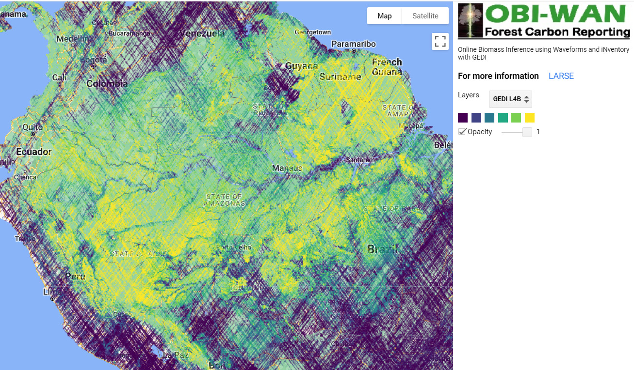
Intro Image. Screenshot of OBI-WAN forest carbon reporting app.

In a recent report (MAAP #199), we presented the updated version of NASA’s GEDI data,1 which uses lasers aboard the International Space Station to provide cutting-edge estimates of aboveground carbon globally, including our focal area, the Amazon.

These lasers, however, have not yet achieved full coverage, leaving considerable gaps in the data and resulting maps.

Here, we feature two new tools that allow us to fill in these gaps and provide detailed wall-to-wall estimates of aboveground biomass for specific areas, which can then be converted to aboveground carbon estimates.

The first is the OBI-WAN forest carbon reporting app (see Intro Image), which uses statistical inference to produce mean, total, and uncertainty estimates for biomass baselines at any given scale (from local to worldwide).2

The second is a fused product from GEDI and TanDEM-X missions.3 The combination of lidar (GEDI) and radar (TanDEM-X) has started to produce unmatched maps that combine the ability of lidar to retrieve forest structure and the ability of radar to offer wall-to-wall coverage at multiple resolutions (see Figures 1-5 below for examples at 25m resolution).

Employing these two tools, we focus on estimating aboveground carbon for select examples of two critical land designations in the Amazon: protected areas and indigenous territories. Both are critical to the long-term conservation of the core Amazon (MAAP #183). We hope that providing precise carbon data will provide additional incentives for their long-term conservation.

We select 5 focal areas (3 National Parks and 2 Indigenous Territories; see list below) across the Amazon to demonstrate the power of these datasets. Together, these five areas are currently home to over 1.4 billion metric tons of aboveground carbon.

  • Protected Areas (National Parks)
    Chirbiquete National Park (Colombian Amazon)
    Manu National Park (Peruvian Amazon)
    Madidi National Park (Bolivian Amazon)
    k
  • Indigenous Territories
    Kayapó Indigenous Territory (Brazilian Amazon)
    Barranco Chico Indigenous Territory (Peruvian Amazon)

Focal Areas

As noted above, the aboveground carbon estimates below are based on the aboveground biomass estimates from the OBI-WAN forest carbon reporting app and GEDI-TanDEM-X data. Figures 1 – 5 are based on GEDI-TanDEM-X, at 25 meter resolution.

National Parks

Chirbiquete National Park (Colombian Amazon)

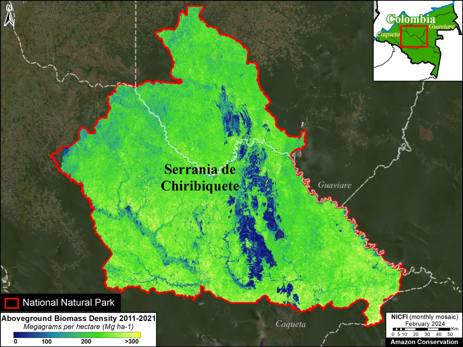
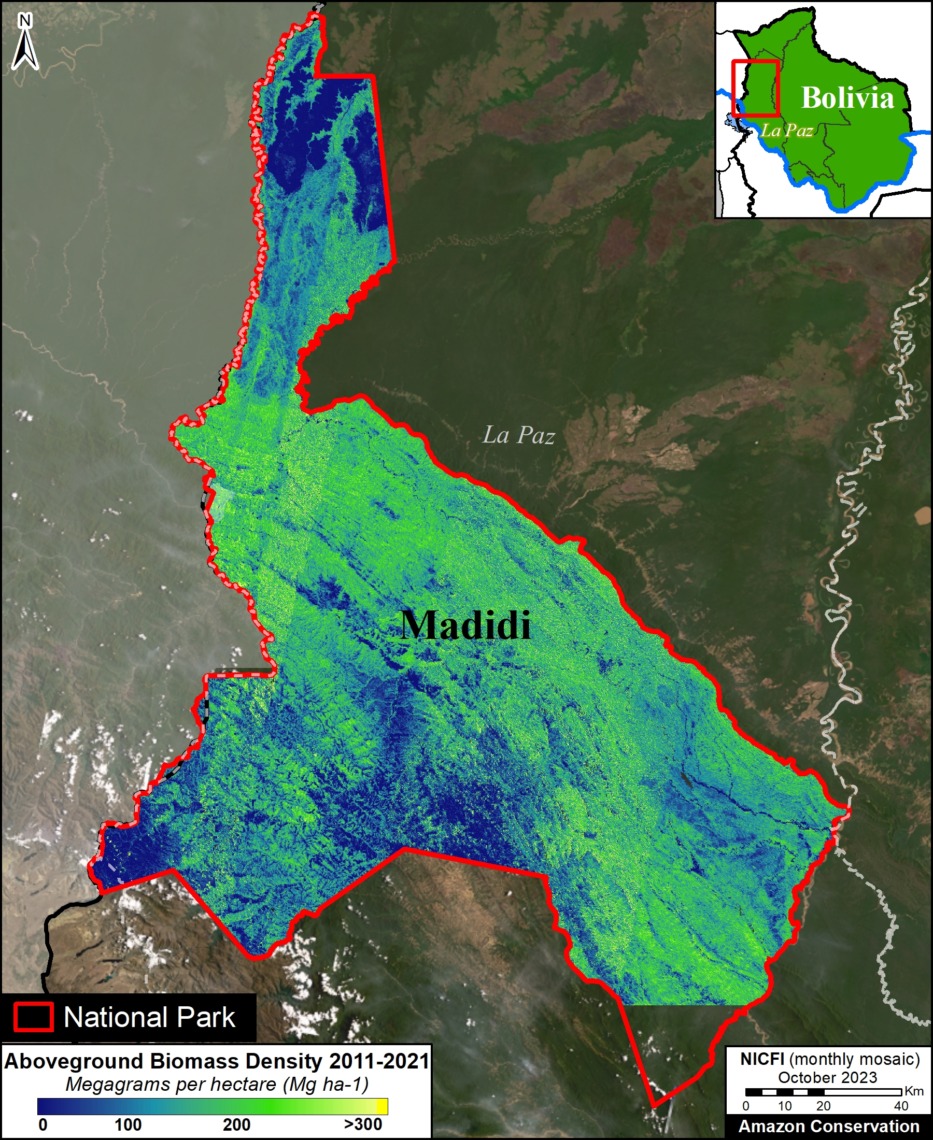
Chirbiquete National Park covers over 4.2 million hectares in the heart of the Colombian Amazon (Guaviare and Caqueta departments). Both datasets converge in the estimate of around 600 metric tons of aboveground biomass, equating to over 300 million metric tons of aboveground carbon across the park (80.5 tons of carbon per hectare). Figure 1 shows the detailed spatial distribution of this biomass across Chirbiquete National Park. Note that the GEDI-TanDEM-X data misses the western tip of the park.

Figure 1. Aboveground biomass across Chiribiquete National Park (Colombian Amazon). Data: GEDI-TanDEM-X


Manu National Park (Peruvian Amazon)

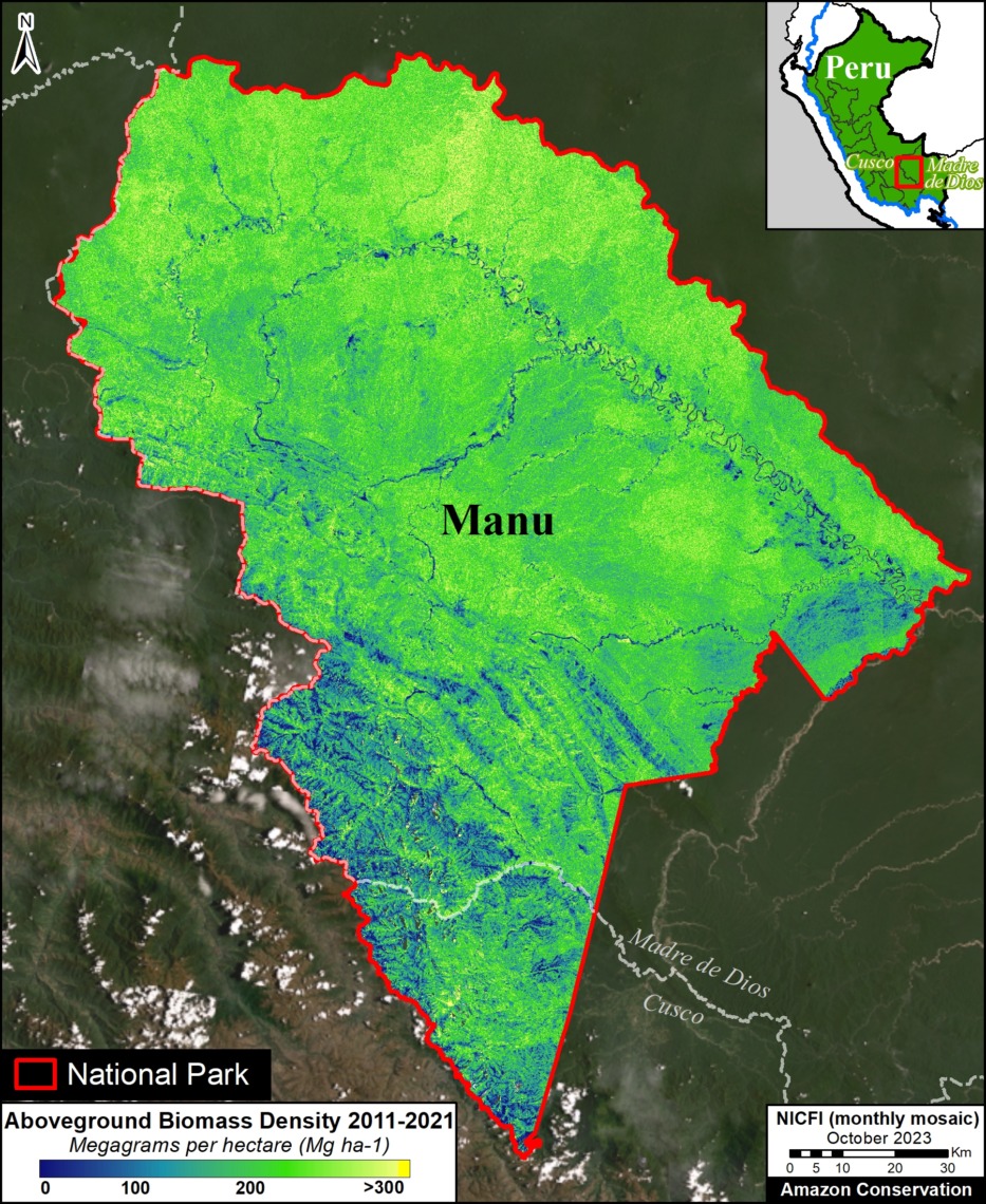
Figure 2. Aboveground biomass across Manu National Park (Peruvian Amazon). Data: GEDI-TanDEM-X

Manu National Park covers over 1.7 million hectares in the southern Peruvian Amazon (Madre de Dios and Cusco regions).

Both datasets converge in the estimate of over 450 metric tons of aboveground biomass, equating to over 215 million metric tons of aboveground carbon across the territory (126.8 tons of carbon per hectare).

Figure 2 shows the detailed spatial distribution of this biomass across Manu National Park.


Madidi National Park (Bolivian Amazon)

Figure 3. Aboveground biomass across Madidi National Park (Bolivian Amazon). Data: GEDI-TanDEM-X

Madidi National Park and Integrated Management Area covers over 1.8 million hectares in the western Bolivian Amazon (La Paz department).

Both datasets converge in the estimate of over 350 metric tons of aboveground biomass, equating to over 160 million metric tons of aboveground carbon across the park (85.3 tons of carbon per hectare).

Figure 3 shows the detailed spatial distribution of this biomass across Madidi National Park. Note that the GEDI-TanDEM-X data misses the southern tip of the park.


Indigenous Territories

Kayapó Indigenous Territory (Brazilian Amazon)

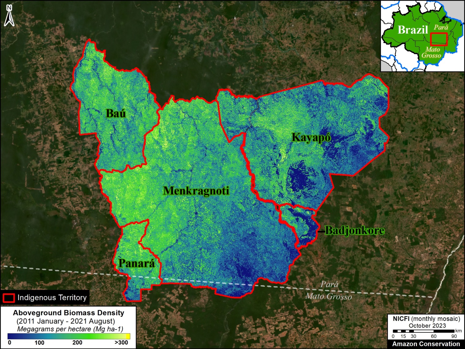
Kayapó Indigenous Territory covers over 3.2 million hectares in the eastern Brazilian Amazon (Pará state). Both datasets converge in the estimate of over 413,000 metric tons of aboveground biomass, equating to over 198 million metric tons of aboveground carbon across the territory. Figure 4 shows the detailed spatial distribution of this biomass across Kayapó and four neighboring Indigenous Territories. Totaling across these five territories (10.4 million hectares), the data sets converge on over 1.5 billion metric tons of aboveground biomass, and 730 million metric tons of aboveground carbon (70 tons per hectare).

Figure 4. Aboveground biomass across Kayapó and neighboring Indigenous Territories (Brazilian Amazon). Data: GEDI-TanDEM-X

Barranco Chico Indigenous Territory (Peruvian Amazon)

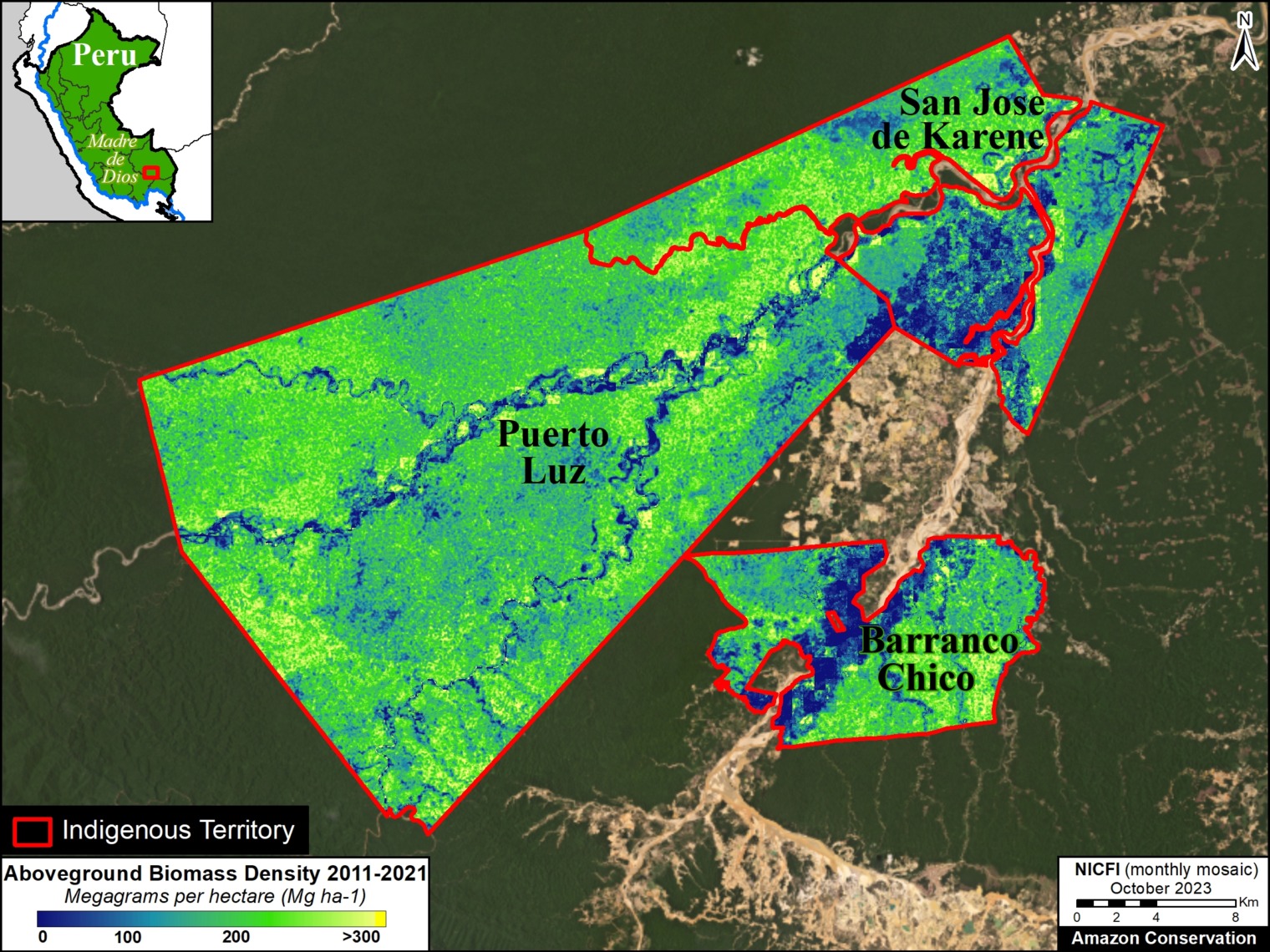
Barranco Chico Indigenous Territory covers over 12,600 hectares in the southern Peruvian Amazon (Madre de Dios region). Both datasets converge in the estimate of over 2 million metric tons of aboveground biomass, equating to over 1 million metric tons of aboveground carbon. Figure 5 shows the detailed spatial distribution of this biomass across Barranco Chico and two neighboring Indigenous Territories (Puerto Luz and San Jose de Karene). Totaling across these three territories (nearly 90,000 hectares), the data sets converge on over 19 million metric tons of aboveground biomass, and over 9 million metric tons of aboveground carbon (102 tons per hectare).

Figure 5. Aboveground biomass across Barranco Chico and neighboring Indigenous Territories (Peruvian Amazon). Data: GEDI-TanDEM-X

Notes

1 GEDI L4B Gridded Aboveground Biomass Density, Version 2.1. This data is measured in megagrams of aboveground biomass per hectare (Mg/ha) at a 1-kilometer resolution, with the period of April 2019 – March 2023. This serves as our estimate for aboveground carbon reserves, with the science-based assumption that 48% of recorded biomass is carbon.

The approach relies on the foundational paper from Patterson et al., (2019) and it is used by the GEDI mission to estimate mean and total biomass worldwide (Dubayh et al., 2022, Armston et al., 2023). The method considers the spatial distribution of GEDI tracks within a given user-specify boundary to infer the sampling error component of the total uncertainty that also includes the error from the GEDI L4A models used to predict biomass from canopy height estimates (Keller et al., 2022). For more information on the OBI-WAN app, see Healey and Yang 2022.

3 GEDI-TanDEM-X (GTDX) is a fusion of GEDI Version 2 and TanDEM-X (TDX) Interferometric Synthetic Aperture Radar (InSAR) images (from Jan 2011 to December 2020). It also incorporates annual forest loss data to account for deforestation during this time. The GTDX aboveground biomass maps were produced based on a generalized hierarchical model-based (GHMB) framework that utilizes GEDI biomass as training data to establish models for estimating biomass based on the GTDX canopy height. The combination of lidar (GEDI) and radar (TanDEM-X) has started to produce unmatched maps that combine the ability of lidar to retrieve forest structure and the ability of radar to offer wall-to-wall coverage (Qi et al.,2023, Dubayah et a;., 2023). This fused product is a wall-to-wall gap-free map that was produced at multiple resolutions: 25m, 100m and 1ha. Ongoing processing over the Pantropic region will be made available over the next months but some geographies have been already mapped such as most of the Amazon Basin (Dubayah et al., 2023). The data we used is publicly available.

References

Armston, J., Dubayah, R. O., Healey, S. P., Yang, Z., Patterson, P. L., Saarela, S., Stahl, G., Duncanson, L., Kellner, J. R., Pascual, A., & Bruening, J. (2023). Global Ecosystem Dynamics Investigation (GEDI)GEDI L4B Country-level Summaries of Aboveground Biomass [CSV]. 0 MB. https://doi.org/10.3334/ORNLDAAC/2321

Dubayah, R. O., Armston, J., Healey, S. P., Yang, Z., Patterson, P. L., Saarela, S., Stahl, G., Duncanson, L., Kellner, J. R., Bruening, J., & Pascual, A. (2023). Global Ecosystem Dynamics Investigation (GEDI)GEDI L4B Gridded Aboveground Biomass Density, Version 2.1 [COG]. 0 MB. https://doi.org/10.3334/ORNLDAAC/2299

Dubayah, R., Armston, J., Healey, S. P., Bruening, J. M., Patterson, P. L., Kellner, J. R., Duncanson, L., Saarela, S., Ståhl, G., Yang, Z., Tang, H., Blair, J. B., Fatoyinbo, L., Goetz, S., Hancock, S., Hansen, M., Hofton, M., Hurtt, G., & Luthcke, S. (2022). GEDI launches a new era of biomass inference from space. Environmental Research Letters, 17(9), 095001. https://doi.org/10.1088/1748-9326/ac8694

Dubayah, R., Blair, J. B., Goetz, S., Fatoyinbo, L., Hansen, M., Healey, S., Hofton, M., Hurtt, G., Kellner, J., Luthcke, S., Armston, J., Tang, H., Duncanson, L., Hancock, S., Jantz, P., Marselis, S., Patterson, P. L., Qi, W., & Silva, C. (2020). The Global Ecosystem Dynamics Investigation: High-resolution laser ranging of the Earth’s forests and topography. Science of Remote Sensing, 1, 100002. https://doi.org/10.1016/j.srs.2020.100002

Healey S, Yang Z (2022) The OBIWAN App: Estimating Property-Level Carbon Storage Using NASA’s GEDI Lidar. https://www.fs.usda.gov/research/rmrs/understory/obiwan-app-estimating-property-level-carbon-storage-using-nasas-gedi-lidar

Kellner, J. R., Armston, J., & Duncanson, L. (2022). Algorithm Theoretical Basis Document for GEDI Footprint Aboveground Biomass Density. Earth and Space Science, 10(4), e2022EA002516. https://doi.org/10.1029/2022EA002516

Dubayah, R.O., W. Qi, J. Armston, T. Fatoyinbo, K. Papathanassiou, M. Pardini, A. Stovall, C. Choi, and V. Cazcarra-Bes. 2023. Pantropical Forest Height and Biomass from GEDI and TanDEM-X Data Fusion. ORNL DAAC, Oak Ridge, Tennessee, USA. https://doi.org/10.3334/ORNLDAAC/2298

Qi, W., J. Armston, C. Choi, A. Stovall, S. Saarela, M. Pardini, L. Fatoyinbo, K. Papathanasiou, and R. Dubayah. 2023. Mapping large-scale pantropical forest canopy height by integrating GEDI lidar and TanDEM-X InSAR data. Research Square. https://doi.org/10.21203/rs.3.rs-3306982/v1

Krieger, G., M. Zink, M. Bachmann, B. Bräutigam, D. Schulze, M. Martone, P. Rizzoli, U. Steinbrecher, J. Walter Antony, F. De Zan, I. Hajnsek, K. Papathanassiou, F. Kugler, M. Rodriguez Cassola, M. Younis, S. Baumgartner, P. López-Dekker, P. Prats, and A. Moreira. 2013. TanDEM-X: A radar interferometer with two formation-flying satellites. Acta Astronautica 89:83–98. https://doi.org/10.1016/j.actaastro.2013.03.008

Acknowledgments

We greatly thank the University of Maryland’s GEDI team for data access and reviewing this report. In particular, we thank Ralph Dubayah, Matheus Nunes, and Sean Healey.

Citation

Mamani N, Pascual A, Finer M (2024) Estimating Carbon in Amazon Protected Areas & Indigenous Territories. MAAP: 213

MAAP #212: Machine learning to detect mining deforestation across the Amazon

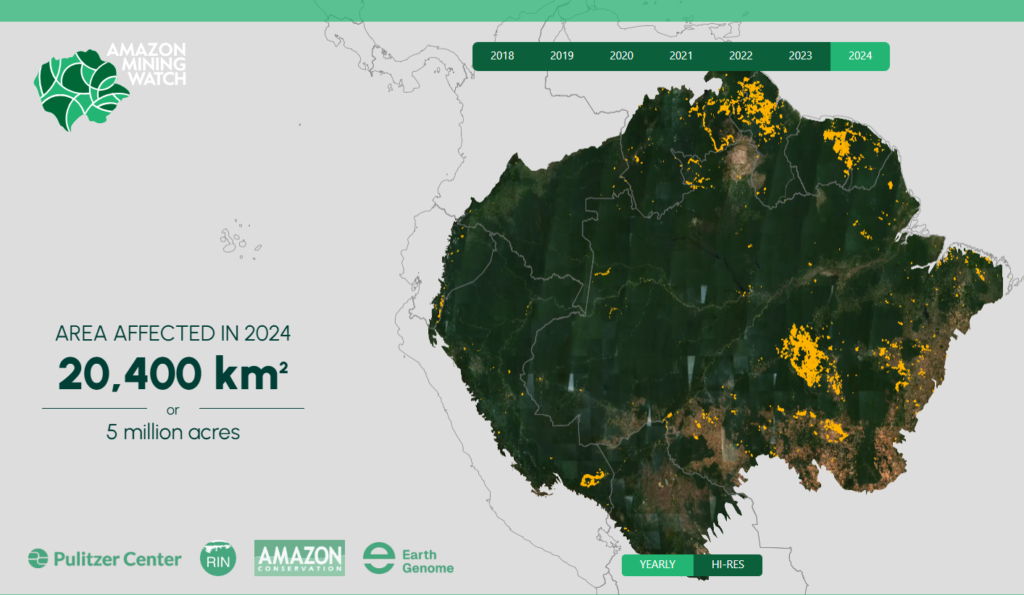
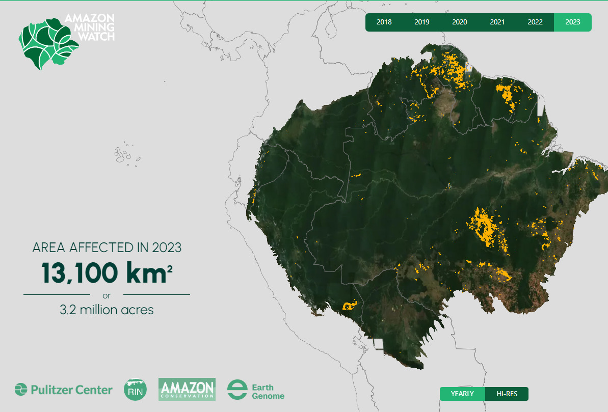
Amazon Mining Watch. Screen shot of the interactive mining deforestation map, displaying data for 2023.

Gold Mining is one of the major deforestation drivers across the Amazon.*

It often targets remote areas, thus impacting carbon-rich primary forests. Moreover, in most cases, this mining is illegal, given that it is occurring in protected areas and indigenous territories.

Given the vastness of the Amazon, however, it has been a challenge to accurately monitor mining deforestation across the entire biome in a timely manner.

Here we present, for the first time, the results of a new machine learning based tool (known as Amazon Mining Watch)  that analyzes satellite imagery archives to detect mining deforestation across the entire Amazon.

Specifically, the tool produces 10-meter resolution mining deforestation alerts based on the European Space Agency’s Sentinel-2 satellite imagery. The alerts currently cover each year annually from 2018 to 2023.

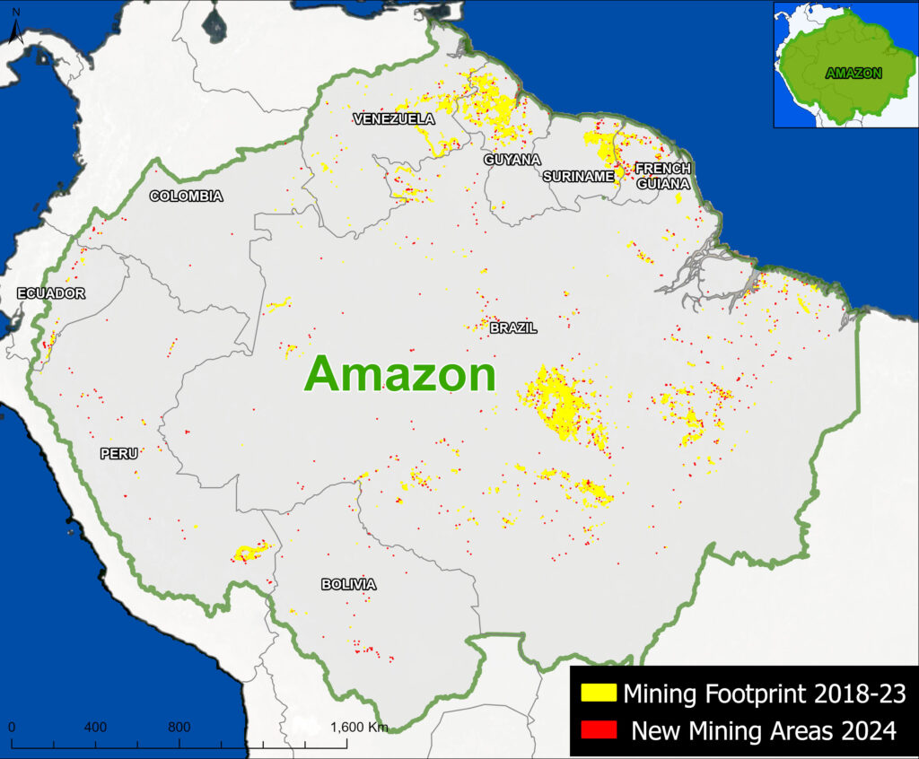
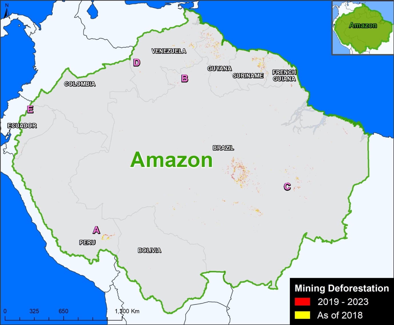
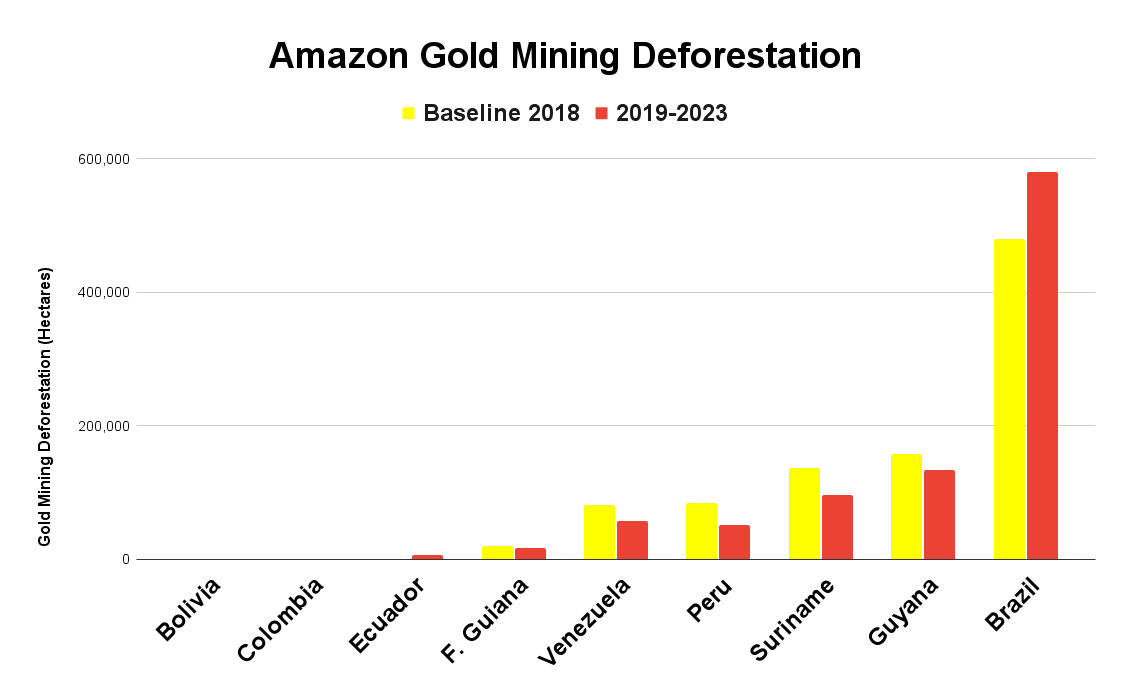
This data reveals that gold mining is actively causing deforestation in all nine countries of the Amazon Biome (see Base Map below). The countries with the most overall mining deforestation are 1) Brazil, 2) Guyana, 3) Suriname, 4) Venezuela, and 5) Peru.

*Note that in this report we focus on mining activity that is causing deforestation. Additional critical gold mining areas in rivers (such as in northern Peru, southeast Colombia, and northwest Brazil; see MAAP #197), are not included in this report or detected/displayed in Amazon Mining Watch.

Major Findings

The Base Map below presents the mining deforestation data across the entire Amazon. Note that yellow indicates the historical mining footprint as of 2018, while red indicates the more recent mining deforestation between 2019 and 2023.

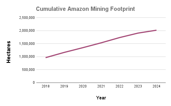
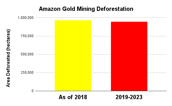
Although the alerts are pixels and not designed for precise area measurements, they can be used to give general estimates. For example, we estimate that as of 2018, there was a historical mining deforestation footprint of over 963,000 hectares across the entire Amazon. Between 2019 and 2023, we estimate that the mining deforestation footprint grew by over 944,000 hectares (2.3 million acres).

Thus, of the total accumulated mining deforestation footprint of over 1.9 million hectares (4.7 million acres), about half has occurred in just the past five years (see Annex).

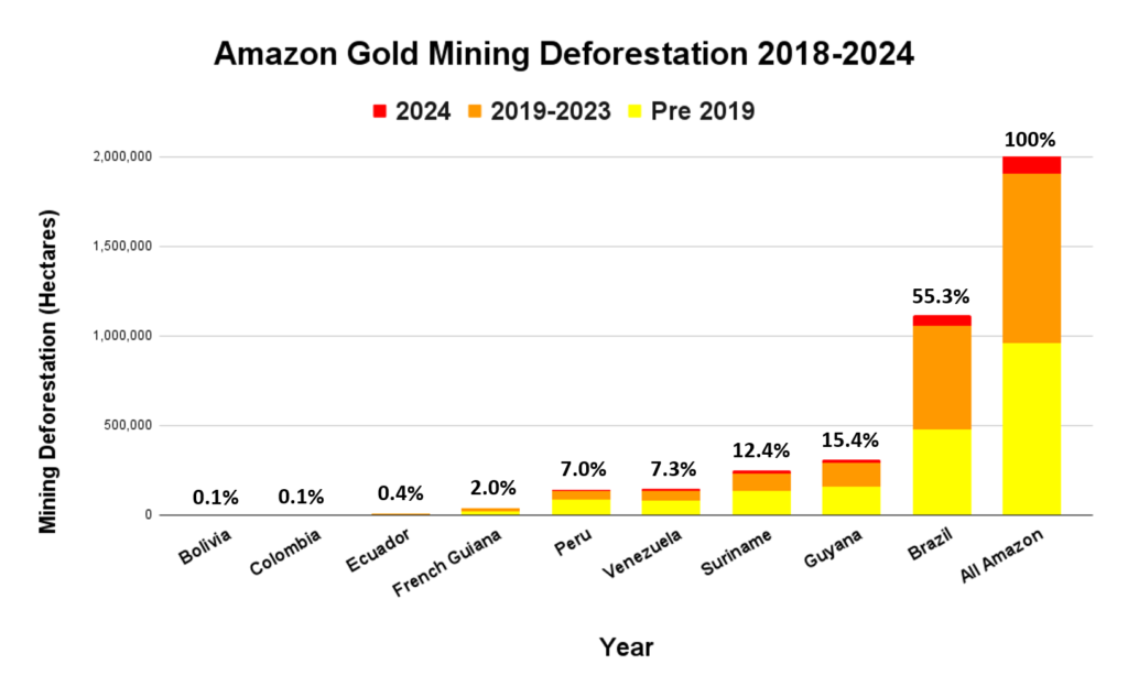
Graph 1 shows, of the total accumulated mining, over half has occurred in Brazil (55%, covering over 1 million hectares), followed by Guyana (15%), Suriname (12%), Venezuela (7%), and Peru (7%, covering 135,625 hectares).

Base Map. Mining deforestation across the Amazon, based on data from Amazon Mining Watch, for the years 2018-2023. Data: AMW, ACA/MAAP.
Graph 1. Mining deforestation across the Amazon, by country. Data: AMW, ACA/MAAP.

Case Studies

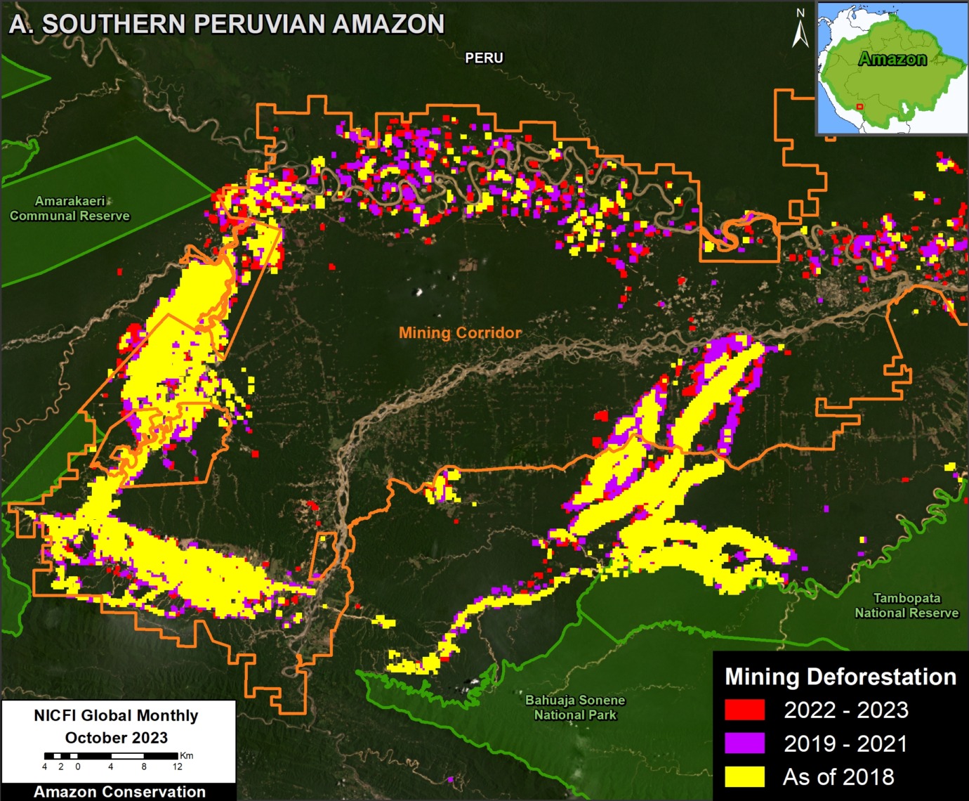
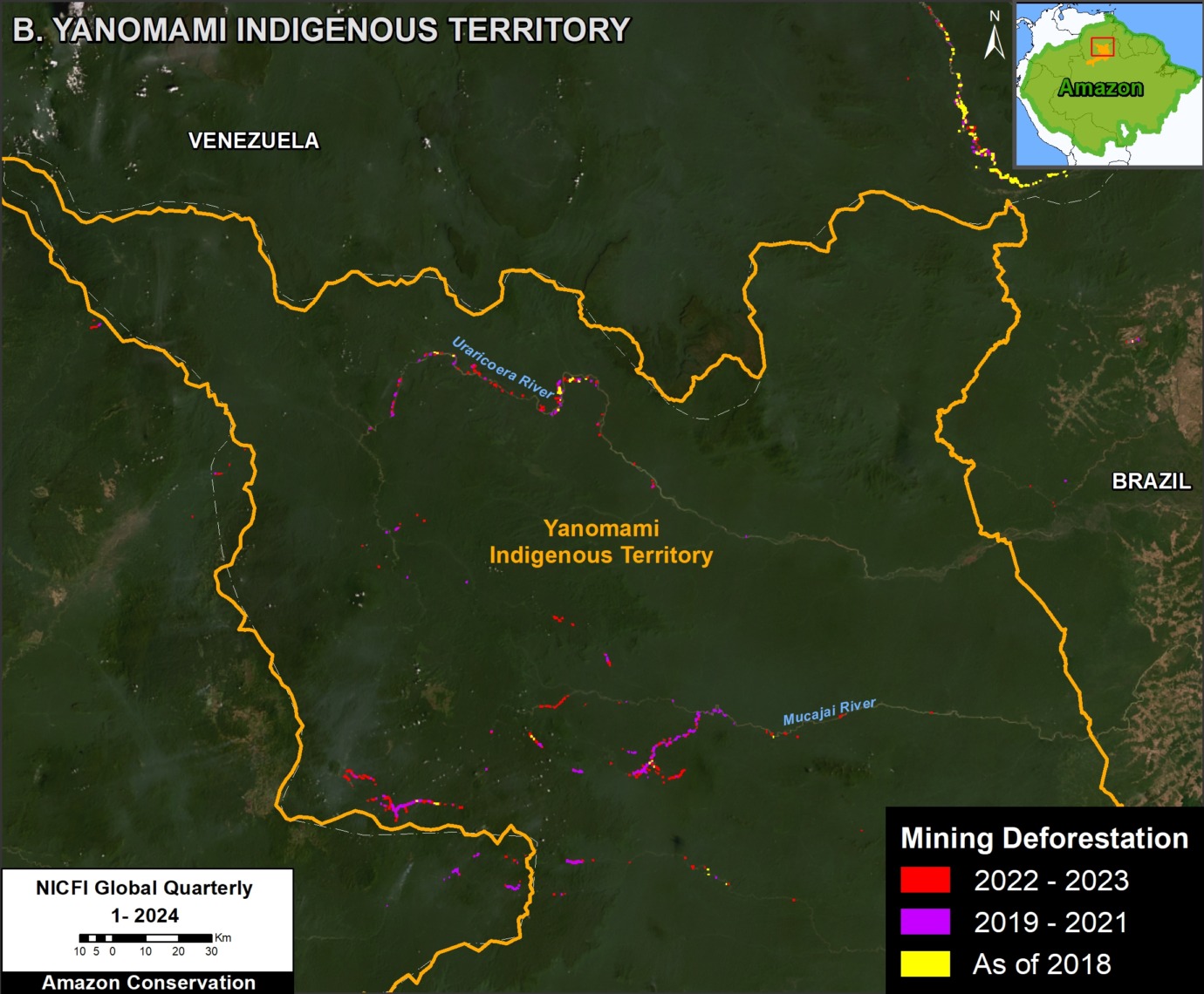
In this section, we show a number of case studies highlighting the power of this data to see the evolution of mining deforestation in the following critical areas (see Insets A-E on Base Map). In these examples, note that yellow indicates the historical mining footprint as of 2018, purple indicates the expansion from 2019-2021, and red indicates the more recent mining deforestation between 2022 and 2023.

A. Southern Peruvian Amazon
B. Brazilian Amazon – Yanomami Indigenous Territory
C. Brazilian Amazon – Kayapó Indigenous Territory
D. Venezuelan Amazon – Yapacana National Park
E. Ecuadorian Amazon – Punino zone

A. Southern Peruvian Amazon

In southern Peru is one of the largest, and likely most emblematic, mining sites in the Amazon (see Inset A in Base Map). Figure 1 shows the dynamic evolution in this area, from several large core mining zones as of 2018, with more recent concentration in the designated Mining Corridor (large area where small-scale mining is permitted by the government as part of a formalization process).

Overall, we recorded over 135,000 hectares (333,590 acres) of mining deforestation in this area. Of this total, 62% (84,000 ha) was present as of 2018, while 38% (51,000 ha) has occurred in just the past five years (2019-2023).

We also highlight that of the total mining deforestation (135,000 ha), 59% has occurred within the Mining Corridor, while 41% (55,000 hectares) is outside the corridor and likely illegal. Note how mining deforestation threatens several protected areas, especially Tambopata National Reserve and Amarakaeri Communal Reserve.

See MAAP #208 for more information about mining deforestation at this site, and how illegal mining also threatens Native Communities.

Figure 1. Evolution of mining deforestation in the southern Peruvian Amazon. Data: AMW, ACA/MAAP.

B. Brazilian Amazon – Yanomami Indigenous Territory

In the northern Brazilian Amazon, the national government recently launched a series of raids against illegal gold mining in Yanomami Indigenous Territory (see Inset B in Base Map). Figure 2 shows a major escalation and expansion of gold mining deforestation since 2018, especially along the Uraricoera and Mucajai Rivers.

Specifically, we documented the total mining deforestation of over 19,000 hectares (47,000 acres) in Yanomami Indigenous Territory. It is critical to emphasize that the vast majority (93%) has occurred in just the past five years (2019-2023).

See MAAP #181 for more information about mining deforestation at this site.

Figure 2. Evolution of mining deforestation in Yanomami Indigenous Territory in Brazil. Data: AMW, ACA/MAAP.

C. Brazilian Amazon – Kayapó Indigenous Territory

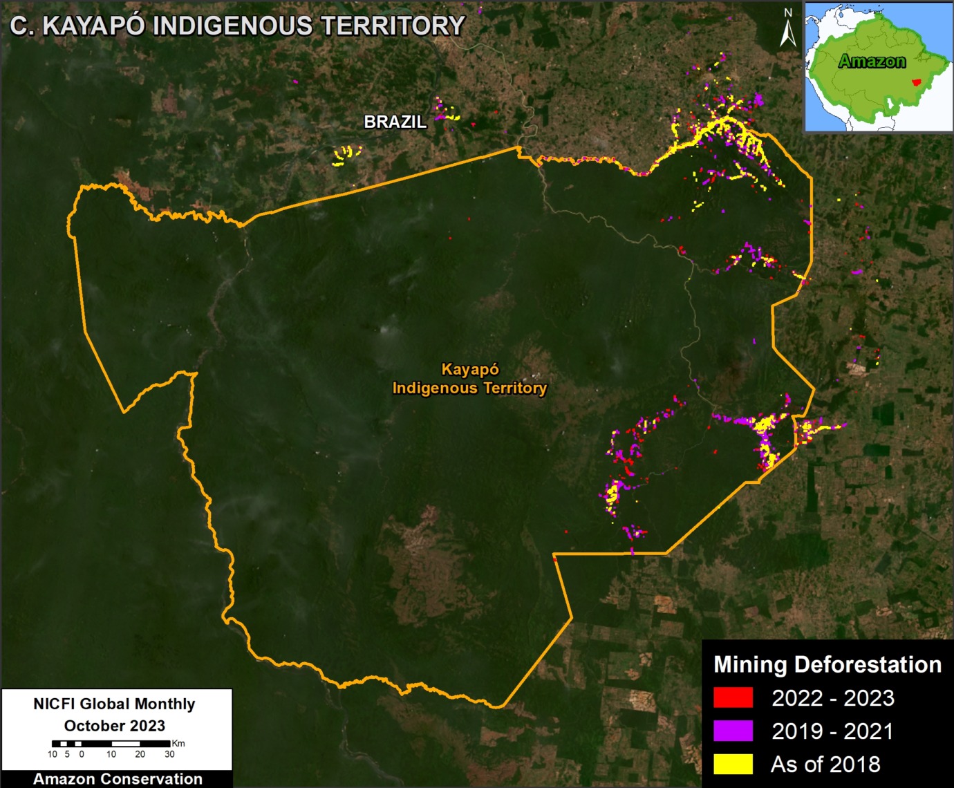
In the eastern Brazilian Amazon, the Kayapó Indigenous Territory is also facing ongoing illegal mining (see Inset C in Base Map). Figure 3 shows the continuing expansion of mining deforestation, mostly in the eastern section of the territory.

We documented the total mining deforestation of nearly 50,000 hectares (123,550 acres) in Kayapó Indigenous Territory. Of this total, 60% (30,000 has) has occurred in just the past five years (2019-2023).

See MAAP #116 for more information about mining deforestation at this site, along with nearby Munduruku Indigenous Territory.

Figure 3. Evolution of mining deforestation in Kayapo Indigenous Territory in Brazil. Data: AMW, ACA/MAAP.

D. Venezuelan Amazon – Yapacana National Park

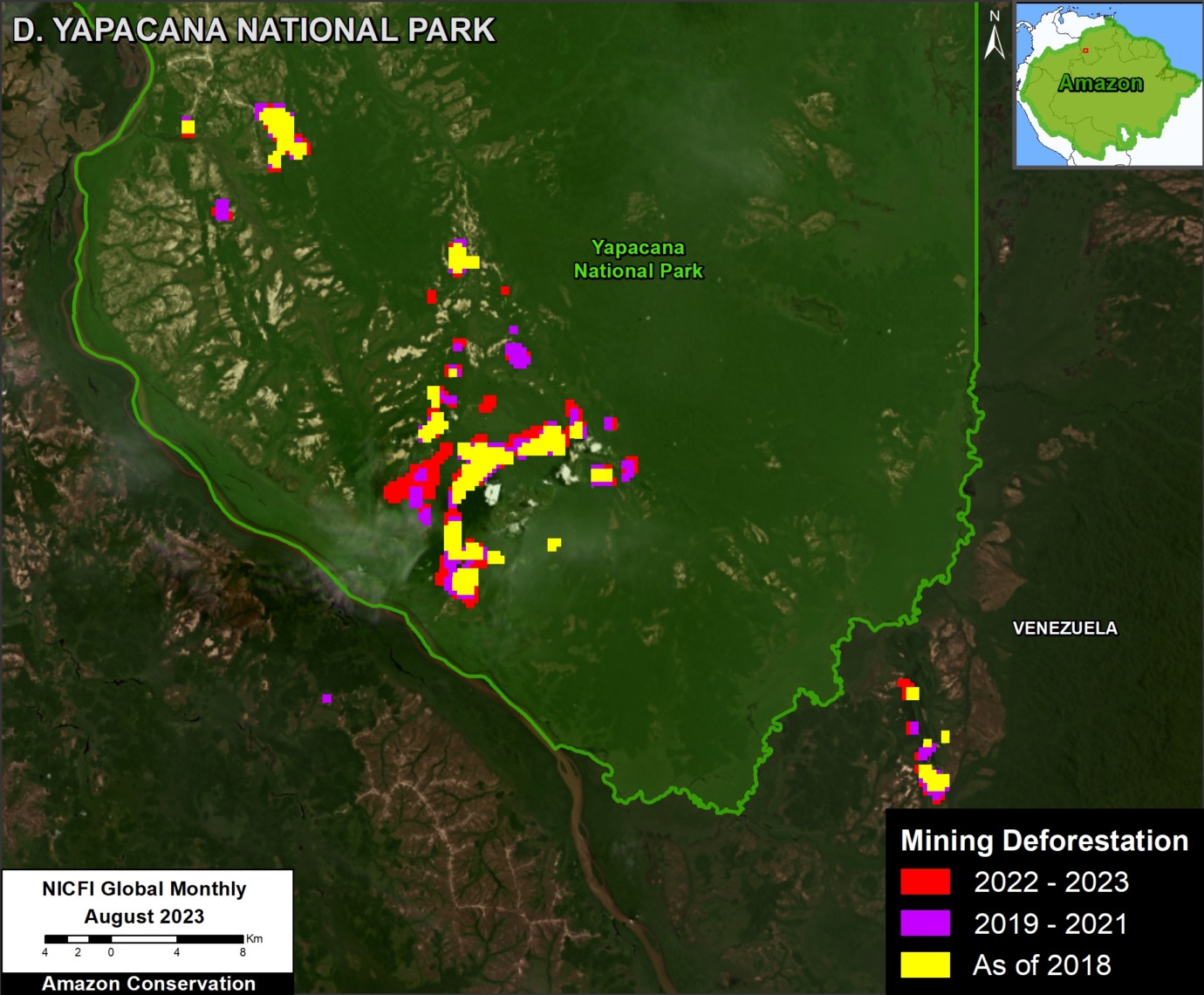
In Venezuela, we see the continued expansion of mining deforestation in Yapacana National Park (see Inset D in Base Map). Indeed, Figure 4 shows the steady expansion of gold mining deforestation at several sites in the southern section of the protected area.

We documented the total mining deforestation of over 6,000 hectares (14,800 acres) in Yapacana National Park. Of this total, just over half (52%; 3,000 has) has occurred in just the past five years (2019-2023).

See MAAP #173 and MAAP #207 for more information about mining deforestation at this site.

Figure 4. Evolution of mining deforestation in Yapacana National Park in Venezuela. Data: AMW, ACA/MAAP.

E. Ecuadorian Amazon – Punino River

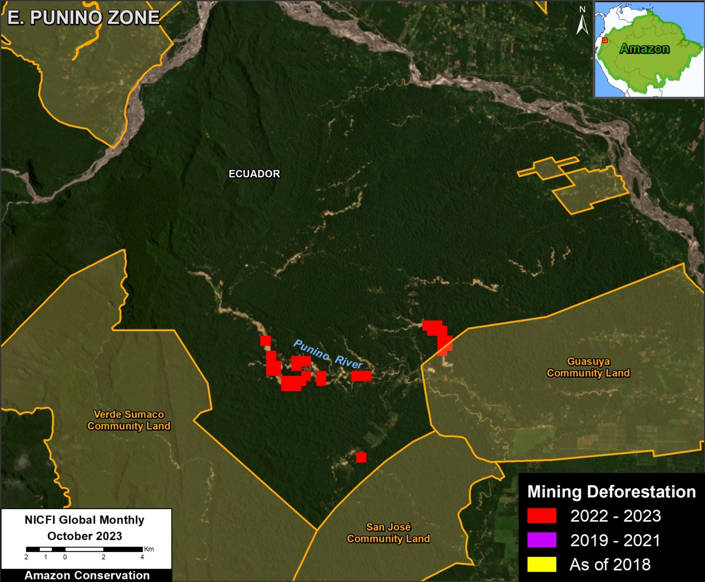
In a series of reports, we have been showing the rapid increase in mining deforestation in the Ecuadorian Amazon (see MAAP #182). One of the main sites is around the Punino River in northern Ecuador (see Inset E in Base Map). Figure 5 shows the sudden emergence of gold mining deforestation near the river.

We documented the total mining deforestation of over 500 hectares (1,235 acres) in the Punino River area. Of this total, 100% is new, all starting in 2023.

See MAAP #206 for more information about mining deforestation at this site.

Figure 5. Evolution of mining deforestation in along the Punino River in Ecuador. Data: AMW, ACA/MAAP.

Annex

As noted above, of the total accumulated mining deforestation footprint of over 1.9 million hectares (4.7 million acres), about half has occurred in just the past five years.

Methods

All data for this report were obtained from Amazon Mining Watch. We only utilized patches with greater than 0.6 mean score. We used the 2018 data as our baseline. For 2019, we masked the previously reported 2018 data to only highlight the new mining that year. We then repeated this process for each subsequent year. For example, the 2023 data masked the 2018-2022 data, indicating only new mining deforestation that year.

Citation

Finer M, Ariñez A (2024) Machine learning to detect mining deforestation across the Amazon. MAAP: #212.

MAAP #199: Amazon Carbon Update, based on NASA’s GEDI Mission

As we approach the COP28 climate summit, starting in Dubai in late November, we provide here a concise update on the current state of remaining Amazon carbon reserves.

We present the newly updated version of NASA’s GEDI data1, which uses lasers aboard the International Space Station to provide cutting-edge estimates of aboveground biomass density on a global scale.

Here, we zoom in on the Amazon and take a first look at the newly updated data, which covers the time period of April 2019 – March 2023.2

This data, which is measured in megagrams of aboveground biomass per hectare (Mg/ha) at a 1-kilometer resolution, serves as our estimate for aboveground carbon reserves.

Figure 1 displays aboveground biomass across the Amazon biome. Note the highest carbon densities (indicated in bright yellow) are located in both the northeast Amazon and southwest Amazon.

Aboveground Biomass across the Amazon

Figure 2 also displays aboveground biomass across the Amazon biome, but this time with country boundaries and labels added.

Note that the peak biomass concentrations in the northeast Amazon include Suriname, French Guiana, and the northeast corner of Brazil. The peak biomass concentrations in the southwest Amazon are centered in southern Peru. Also note that many parts of Ecuador, Colombia, Venezuela, Guyana, Bolivia, Brazil, and northern Peru have high carbon densities as well.

Figure 2. Aboveground biomass density (carbon estimate) across the Amazon biome, with country boundaries. Data: NASA/GEDI, NICFI.

Carbon Estimates

We calculated over 78 billion metric tons of aboveground biomass across the Amazon biome (78,184,161,090 metric tons to be exact). Using a general assumption that 48% of this biomass is carbon3, we estimate over 37 billion metric tons of carbon across the Amazon (37,528,397,323 metric tons).

Note that these totals are likely underestimates given that the laser-based data has not yet achieved full coverage across the Amazon (that is, there are many areas where the lasers have not yet recorded data, leaving visible blanks in the maps above).

This is consistent with a previous study based on another independent dataset, where we estimated 6.7 billion metric tons of carbon in the Peruvian Amazon as of 2013 (MAAP #148). The current GEDI data estimates at least 5.3 billion metric tons in the Peruvian Amazon.

Carbon Sink

In a previous report, we showed that the Brazilian Amazon has become a net carbon source, whereas the total Amazon is still a net carbon sink (MAAP #144). Our current report goes one step further in terms of showing just how much carbon is left in that sink.

Notes

1GEDI L4B Gridded Aboveground Biomass Density, Version 2.1. https://daac.ornl.gov/cgi-bin/dsviewer.pl?ds_id=2299

2Note that we previously reported on the initial data release, which covered the time period of April 2019 – August 2021 (see MAAP #160).

3Domke et al (2022) How Much Carbon is in Tree Biomass?. USDA/Forest Service.

Acknowledgements

This work was supported by NORAD (Norwegian Agency for Development Cooperation) and ICFC (International Conservation Fund of Canada).

Citation

Mamani N, Finer M, Ariñez A (2022) Amazon Carbon Update, based on NASA’s GEDI Mission. MAAP: 199.

MAAP #189: Amazon Fire Season Heats Up

Image 1. Example of 2023 (June 29) major fire in Brazilian Amazon.

The Amazon fire season is well under way: to date, we have detected over 260 major fires thus far in 2023 (see Base Map below).

This year is of special concern because scientists indicate we have entered a new El Niño episode. The most intense Amazon fire seasons on record, 2016 and 2017, immediately followed the last major El Niño event.

Most of the fires (54%) this year have occurred in the Brazilian Amazon.

Of these, the vast majority (73%) have burned r­­­­ecently deforested areas. This high number is consistent with previous years (see MAAP #168) and once again highlights the critical link between deforestation and fires in the Brazilian Amazon. That is, most major fires are burning the remnants of a recent deforestation event.

It is also worth noting that many of the fires in the Brazilian Amazon (42%) were burning areas recently deforested specifically for new soy plantations.

We have thus far detected 40 major fires in the Bolivian Amazon. The vast majority (88%) have been burning areas recently deforested specifically for new soy plantations.

We have detected an additional 30 major fires in the Peruvian Amazon, mostly burning high elevation grasslands.

Earlier in the year, between January and March, we detected 50 major fires in the Colombian Amazon. Notably, 100% of them were in burning recently deforested areas.

These findings are based on the unique data from the real-time Amazon Fires Monitoring app developed by our partner organization in Peru, Conservación Amazónica ACCA. In a novel approach, the app combines data from the atmosphere (aerosol emissions in smoke) and the ground (heat anomaly alerts) to quickly and precisely detect major fires, defined as fires burning abundant biomass. In short, the app filters out smaller fires (such as routine burning an old field) and highlights major fires (such as burning recently deforested areas, standing forest, or natural grasslands).

2023 Major Amazon Fires Base Map

Base Map. 2023 major Amazon fires (through July 2023). Data: ACCA, ACA/MAAP.

Amazon Fires Dashboard

We also present our new Amazon fires dashboard, which currently shows results for the 2022 fire season. The dashboard highlights a number of the key findings from last year:

  • We detected 983 major fires.
  • The vast majority (72%) were in Brazil, followed by Bolivia, Peru, and Colombia.
  • Importantly, 73% of the major fires burned recently deforested areas, followed by grasslands, forest fires, and pasture.

The dashboard was developed by the SAS Institute’s Data for Good Program.

Methodology

The reported results are based on an analysis of data generated by a unique real-time Amazon Fires Monitoring app during the year 2023, through July 13.

The app, hosted by Google Earth Engine, was developed and updated daily by the Peru-based organization Conservación Amazónica (ACCA). The resulting data was analyzed and recorded daily by the US-based organization Amazon Conservation. The app was created in 2019 and upgraded in 2020, with the current version launching in May 2021.

When fires burn, they emit gases and aerosols (aerosol definition: Suspension of fine solid particles or liquid droplets in air or another gas) as part of the outgoing smoke. A relatively new satellite (Sentinel-5P from the European Space Agency) detects these aerosol emissions.

The aerosol data, which has a spatial resolution of 7.5 sq km, is not impacted by cloud cover, thus enabling near real-time monitoring during all weather conditions. The app is typically updated each day in the late afternoon/early evening with data for that same day. Thus, there is a high potential for authorities and civil society to also use this app to respond to major fires in the field.

Importantly, the app distinguishes small fires (such as from clearing old fields and thus burning little biomass) from larger fires (such as burning recently deforested areas or standing forests and thus burning high amounts of biomass).

We define a “major fire” as one showing elevated aerosol emission levels on the app, thus indicating the burning of elevated levels of biomass. This typically translates to an aerosol index (AI) of >1 (or cyan-green to red on the app).

In a novel approach, the app combines this aerosol data from the atmosphere with heat anomaly data from the ground.

For all detected major fires, we cross-referenced the aerosol emissions pattern with the ground heat-based data to pinpoint the exact location of the fire source. Typically for major fires, there is a large cluster of heat-anomaly alerts aiding the process.

In a final step, the detected major fires are then analyzed with high-resolution optical satellite imagery from Planet Explorer. With this imagery, we can confirm the major fire (by observing smoke on the day of the fire or a burned area scar in the days following the fire) and estimate its size.

Moreover, with Planet’s extensive satellite imagery archive, we can determine the fire type. That is, by comparing imagery from the fire date to previous dates, we can determine whether the fire was burning a) a recently deforested area (defined as fires in areas recently deforested during the past three years), b) an older deforested area (typically long-standing pasture areas), c) standing forest (that is, a forest fire), or natural savannah.

In the app, we can also cross-reference if a major fire has occurred within a protected area or titled indigenous territory.

Note that the high values in the aerosol indices may also be due to other reasons such as emissions of volcanic ash or desert dust so it is important to cross-reference elevated emissions with heat data and optical imagery.

Acknowledgements

This work was supported by Norad (Norwegian Agency for Development Cooperation) and ICFC (International Conservation Fund of Canada).

Citation

Finer M, Costa H, Villa L (2023) Amazon Fire Season Heats Up. MAAP: 189.

MAAP #187: Amazon Deforestation & Fire Hotspots 2022

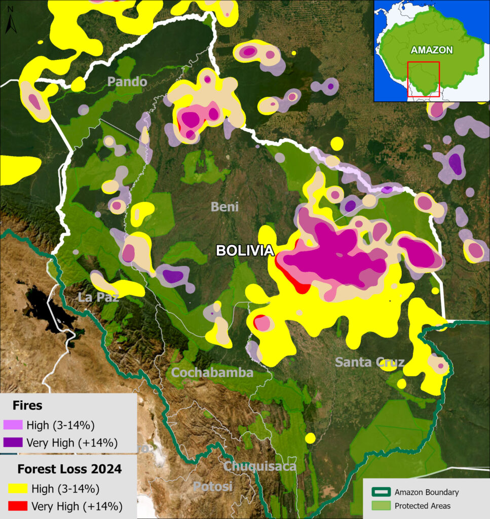
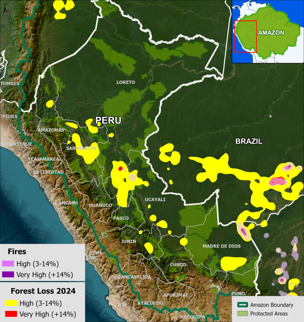
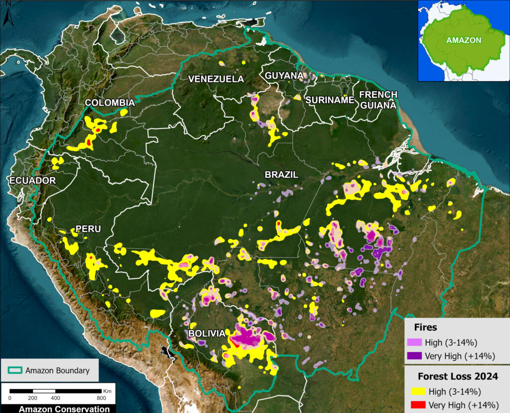
2022 Amazon Forest Loss Base Map. Deforestation and fire hotspots across the full Amazon biome. Data: UMD/GLAD, ACA/MAAP.

We present a detailed look at the major 2022 Amazon forest loss hotspots, based on the final annual data recently released by the University of Maryland (and featured on Global Forest Watch).

This dataset is unique in that it is consistent across all nine countries of the Amazon, and distinguishes forest loss from fire, leaving the rest as a proxy for deforestation (but also includes natural loss).

Thus, we are able to present both deforestation and fire hotspots across the Amazon.

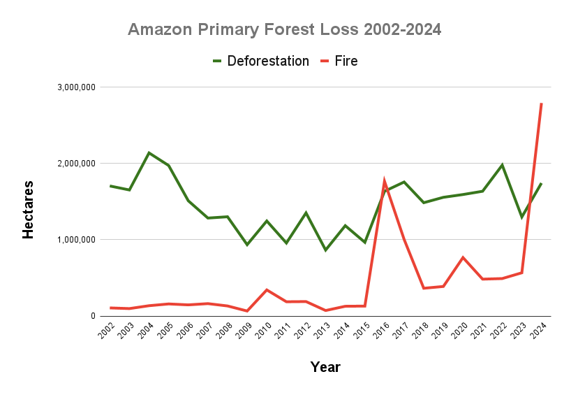
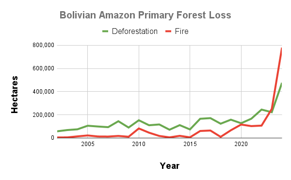
The Base Map (see right) and Results Graph (see below) reveal several key findings:

  • In 2022, we estimate the deforestation of 1.98 million hectares (4.89 million acres). This represents a major 21% increase from 2021, and is the second highest on record, behind only the peak in 2004.
    k
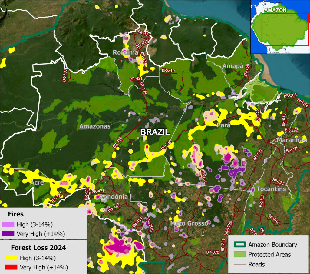
  • Deforestation hotspots were especially concentrated along roads in the Brazilian Amazon, the soy frontier in the southeast Bolivian Amazon, and near protected areas in northwest Colombian Amazon.
    k
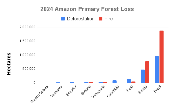
  • The vast majority of the deforestation occurred in Brazil (72.8%), followed by Bolivia (12.4%)Peru (7.3%), and Colombia (4.9%). Note that deforestation in Bolivia was the highest on record, and in Brazil the highest since the early 2000s.
    k
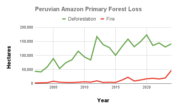
  • Fires impacted an additional 491,223 hectares (1.2 million acres) of primary forest. This total represents a 1.6% increase from 2021, and the 4th highest on record (behind only intense fire seasons of 2016, 2017, and 2020). Moreover, each of the seven most intense fire seasons has occurred in the past seven years. Nearly 93% of the fire impact occurred in just two countries: Brazil and Bolivia.
    k
  • In total, 2.47 million hectares (6.1 million acres) of primary forest were impacted by deforestation and fire. This total represents the third highest on record, only behind the post-El Niño years of 2016 and 2017.
    k
  • Since 2002, we estimate the deforestation of 30.7 million hectares (75.9 million acres) of primary forest, greater than the size of Italy or the U.S. state of Arizona.

Below, we zoom in on the six countries with the highest deforestation (Brazil, Bolivia, Peru, Colombia, Ecuador, and Venezuela) with additional maps and analysis.

Amazon Primary Forest Loss (Combined), 2002-2022

Amazon Forest Loss Results Graph, 2002-22. Data: UMD/GLAD, ACA/MAAP.

Amazon Primary Forest Loss (By Country), 2002-2022

Brazilian Amazon

Brazil Base Map, 2022. Deforestation and fire hotspots in the Brazilian Amazon in relation to major roads. Data: UMD/GLAD, ACA/MAAP.

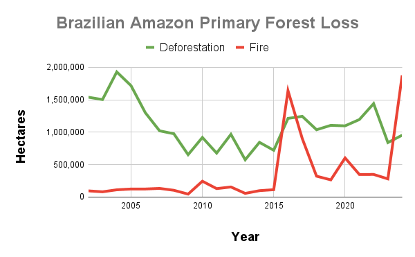
In 2022, the Brazilian Amazon lost 1.4 million hectares (3.56 million acres) of primary forest to deforestation. Fires directly impacted an additional 348,824 hectares.

The deforestation rose 20.5% from 2021, and was the highest on record since the peak years of 2002 – 2005.

The fire impact was the 4th highest on record, only behind the intense fire years of 2016, 2017, and 2020.

The deforestation was concentrated along the major road networks, especially roads 230 (Trans-Amazonian Highway), 364, 319, and 163 in the states of Amazonas, Pará, Rondônia, and Acre (see Brazil Base Map).

The direct fire impacts were concentrated in the soy frontier, located in southeastern state of Mato Grosso


Bolivian Amazon

Bolivia Base Map, 2022. Deforestation and fire hotspots in Bolivian Amazon. Data: UMD/GLAD, ACA/MAAP.

In 2022, the Bolivian Amazon lost 245,177 hectares of primary forest to deforestation. Fires directly impacted an additional 106,922 hectares.

We highlight that this deforestation was 47% higher than 2021, and the highest on record (by far).

The fire impact was also up from last year, and the second-highest on record behind just the intense year of 2020.

Both the deforestation and fires were concentrated in the soy frontier located in southeastern department of Santa Cruz (see Bolivia Base Map).


Peruvian Amazon

Peru Base Map, 2022. Deforestation and fire hotspots in the Peruvian Amazon. Data: UMD/GLAD, ACA/MAAP.

In 2022, the Peruvian Amazon lost 144,682 hectares of primary forest to deforestation. Fires directly impacted an additional 16,408 hectares.

Deforestation increased 6.7% from 2021, and was the 5th highest on record. Fire impact decreased from last year, but was still relatively high.

The deforestation was concentrated in the central and southern Amazon (Ucayali and Madre de Dios regions, respectively) (see Peru Base Map).

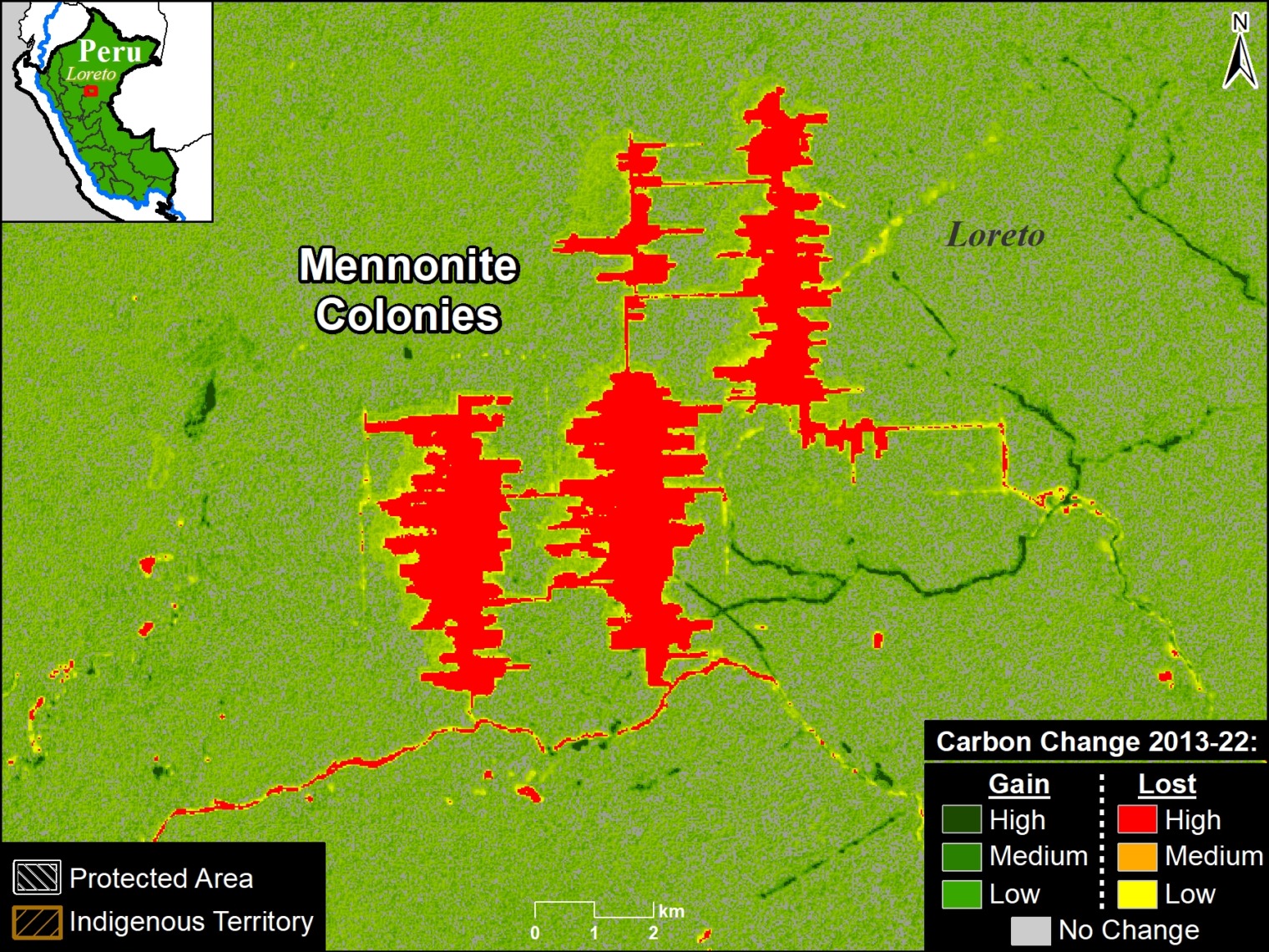
In the central Amazon, we highlight the rapid deforestation for a new Mennonite colony (see MAAP #166).

In the southern Amazon, gold mining deforestation continues to be an issue in indigenous communities and within the official Mining Corridor.


Colombian Amazon

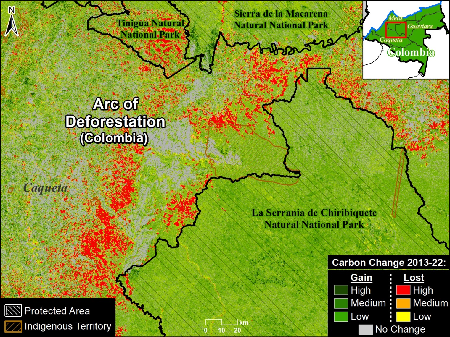
Colombia Base Map, 2022. Deforestation and fire hotspots in northwest Colombian Amazon. Data: UMD/GLAD, ACA/MAAP, FCDS.

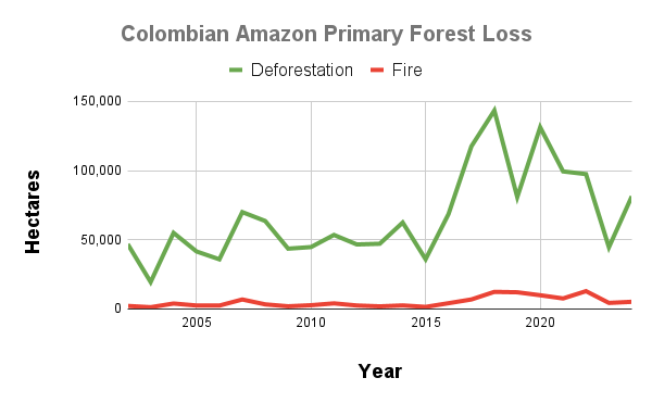
In 2022, the Colombian Amazon lost 97,417 hectares of primary forest to deforestation. Fires directly impacted an additional 12,880 hectares.

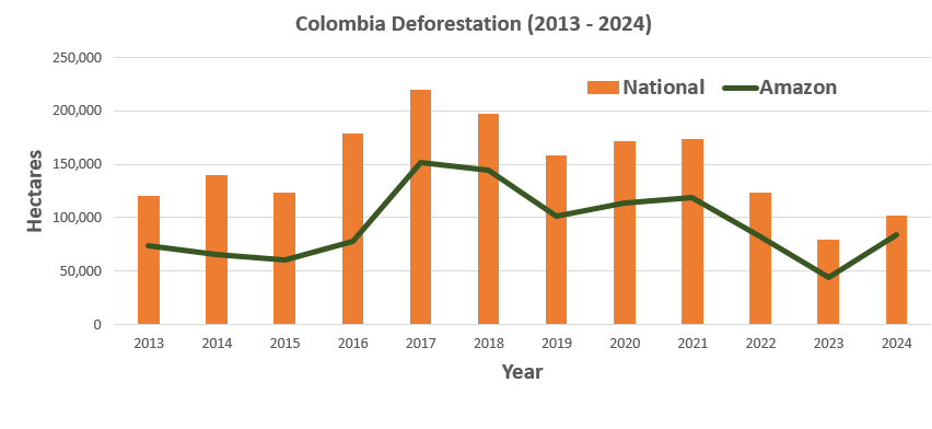
Deforestation decreased 2% from 2021, but it was still relatively high (5th highest on record), continuing the trend of elevated forest loss since the FARC peace agreement in 2016.

Fire impact increased from last year and was actually the highest on record, edging out 2018 and 2019.

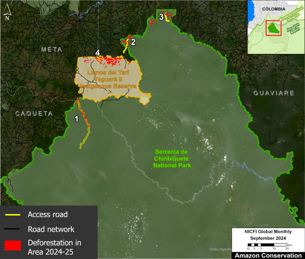
As described in previous reports (see MAAP #120), the Colombia Base Map shows there continues to be an “arc of deforestation” in the northwest Colombian Amazon (Caqueta, Meta, and Guaviare departments).

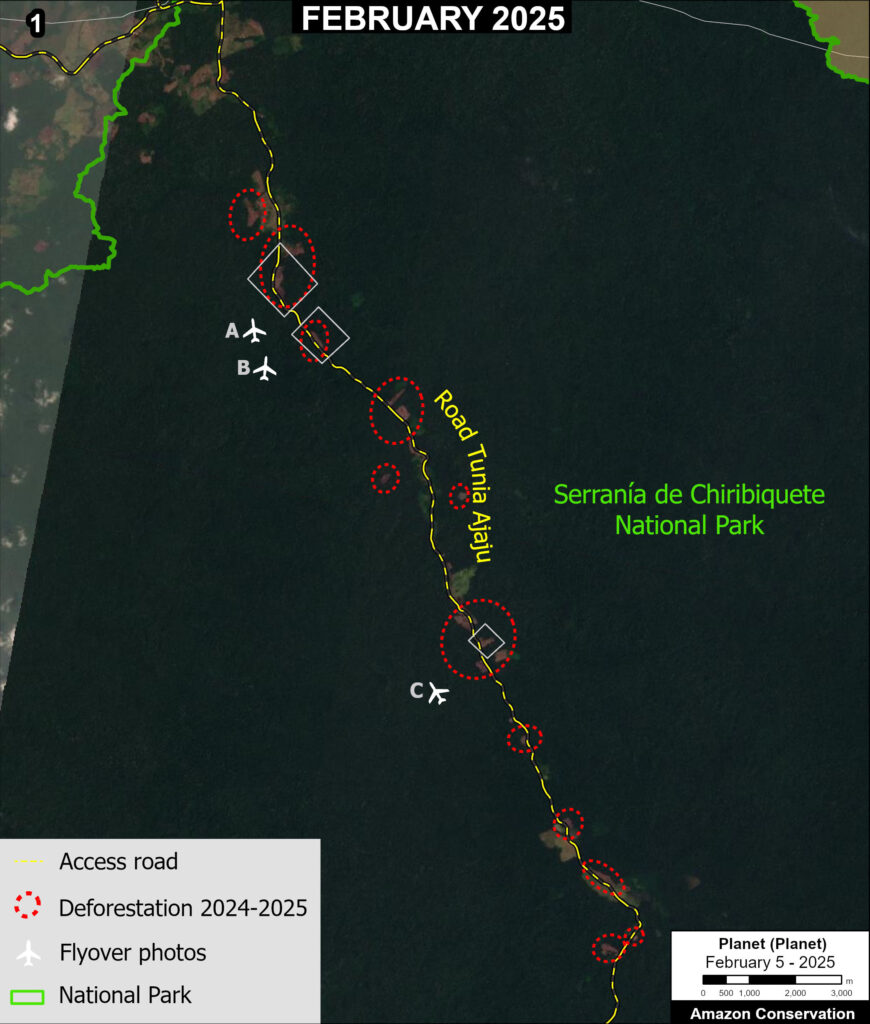
This arc impacts numerous Protected Areas (particularly Tinigua and Chiribiquete National Parks) and Indigenous Reserves (particularly Yari-Yaguara II and Nukak Maku).


Ecuadorian Amazon

Ecuador Base Map, 2022. Deforestation and fire hotspots in the Ecuadorian Amazon. Data: UMD/GLAD, ACA/MAAP.

Although accounting for just 1% of total loss across the Amazon, deforestation in the Ecuadorian Amazon was the highest on record in 2022 (18,902 hectares), up a striking 80% since 2021.

There are several deforestation hotspots caused by gold mining (see MAAP #182), oil palm plantation expansion, and small-scale agriculture.


Venezuelan Amazon

In the Venezuelan Amazon, deforestation was on par with last year (12,584 hectares).

There is a deforestation hotspot caused by gold mining in Yapacana National Park (see MAAP #173, MAAP #156, MAAP #169).

There are also hotspots in the Orinoco Mining Arc caused by mining and agriculture.


Methodology

The analysis was based on 30-meter resolution annual forest loss data produced by the University of Maryland and also presented by Global Forest Watch.

This data was complemented with the Global Forest Loss due to fire dataset that is unique in terms of being consistent across the Amazon (in contrast to country specific estimates) and distinguishes forest loss caused directly by fire (note that virtually all Amazon fires are human-caused). The values included were ‘medium’ and ‘high’ confidence levels (code 3-4).

The remaining forest loss serves as a likely close proxy for deforestation, with the only remaining exception being natural events such as landslides, wind storms, and meandering rivers. The values used to estimate this category was ‘low’ certainty of forest loss due to fire (code 2), and forest loss due to other ‘non-fire’ drivers (code 1).

For the baseline, it was defined to establish areas with >30% tree canopy density in 2000. Importantly, we applied a filter to calculate only primary forest loss by intersecting the forest cover loss data with the additional dataset “primary humid tropical forests” as of 2001 (Turubanova et al 2018). For more details on this part of the methodology, see the Technical Blog from Global Forest Watch (Goldman and Weisse 2019).

Our geographic range for the Amazon is a hybrid designed for maximum inclusion: biogeographic boundary (as defined by RAISG) for all countries, except for Bolivia and Peru, where we use the watershed boundary, and Brazil, where we use the Legal Amazon boundary.

To identify the deforestation hotspots, we conducted a kernel density estimate. This type of analysis calculates the magnitude per unit area of a particular phenomenon, in this case, forest cover loss. We conducted this analysis using the Kernel Density tool from the Spatial Analyst Tool Box of ArcGIS. We used the following parameters:

Search Radius: 15000 layer units (meters)
Kernel Density Function: Quartic kernel function
Cell Size in the map: 200 x 200 meters (4 hectares)
Everything else was left to the default setting.

For the Base Map, we used the following concentration percentages: High: 3-14%; Very High: >14%.

Acknowledgements

We thank colleagues at Global Forest Watch (GFW), an initiative of the World Resources Institute (WRI) for comments and access to data.

This work was supported by Norad (Norwegian Agency for Development Cooperation) and ICFC (International Conservation Fund of Canada).

Citation

Finer M, Mamani N (2023) Amazon Deforestation & Fire Hotspots 2022. MAAP: 187

MAAP #183: Protected Areas & Indigenous Territories Effective Against Deforestation Across Amazon

Base Map. Primary forest loss (2017-21) across the Amazon, in relation to protected areas and indigenous territories.

As deforestation continues to threaten primary forest across the Amazon, key land use designations are one of the best hopes for the long-term conservation of critical remaining intact forests.

Here, we evaluate the impact of two of the most important: protected areas & indigenous territories.

Our study looked across all nine countries of the Amazon biome, a vast area of 883.7 million hectares (see Base Map).

We calculated primary forest loss over the past 5 years (2017-2021).

For the first time, we were able to distinguish fire vs non-fire forest loss. For non-fire, while this does include natural events (such as landslides and wind storms), we consider this our best proxy for human-caused deforestation.

We analyzed the results across three major land use categories:

1) Protected Areas (national and state/department levels), which cover 197 million hectares (23.6% of Amazon).

2) Indigenous Territories (official), which cover 163.8 million hectares (19.6% of Amazon).

3) Other (all remaining areas outside protected areas and indigenous territories), which cover 473 million hectares (56.7% of Amazon).

In summary, we found that deforestation was the primary driver of forest loss, with fire always being a smaller subset. Averaged across all 5 years, protected areas and indigenous territories had similar levels of effectiveness, reducing primary forest loss rate by 3x compared to areas outside of these designations.

Below, we show the key results across the Amazon in greater detail, including a breakdown for the western Amazon (Bolivia, Colombia, Ecuador, and Peru) and the Brazilian Amazon.

Key Findings

Amazon Biome

We documented the loss of 11 million hectares of primary forests across all nine countries of the Amazon biome between 2017 and 2021. Of this total, 71% was non-fire (deforestation and natural) and 29% was fire.

For the major land use categories, 11% of the forest loss occurred in both protected areas and indigenous territories, respectively, while the remaining 78% occurred outside these designations.

To standardize these results for the varying area coverages, we calculated annual primary forest loss rates (loss/total area of each category). Figure 1 displays the results for these rates across all nine countries of the Amazon biome.

Figure 1. Primary forest loss rates across the Amazon, 2017-21.

Broken down by year, 2017 had the highest forest loss rates, with both a severe deforestation and fire season. In addition, 2021 had the second highest deforestation rate, while 2020 had the second highest fire loss rate.

Averaged across all five years, protected areas (green) had the lowest overall primary forest loss rate (0.12%), closely followed by indigenous territories (0.14%).

Interestingly, indigenous territories (orange) actually had a slightly lower deforestation rate compared to protected areas (0.7 vs 0.8%), but higher fire loss rate (o.7 vs .04%), resulting in the overall higher forest loss rate noted above.

Outside of these designations (red), the primary forest loss rate was triple (.36%), especially due to much higher deforestation.

Western Amazon

Breaking the results down specifically for the western Amazon (Bolivia, Colombia, Ecuador, and Peru), we documented the loss of 2.6 million hectares of primary forests between 2017 and 2021. Of this total, 80% was non-fire (deforestation and natural) and 20% was fire.

For the major land use categories, 9.6% occurred in protected areas, 15.6% in indigenous territories, and the remaining 74.8% occurred outside these designations.

Figure 2 displays the standardized primary forest loss rates across the western Amazon.

Figure 2. Primary forest loss rates across the Western Amazon, 2017-21.

Broken down by year, 2017 had the highest deforestation rate and overall forest loss rates. But 2020 had the highest fire loss rate, mainly due to extensive fires in Bolivia. 2021 also had a relatively high deforestation rate. Also, note the high level of fires in protected areas in 2020 and 2021, and indigenous territories in 2019.
Averaged across all five years, protected areas had the lowest overall primary forest loss rate (0.11%), followed by indigenous territories (0.16%).
Outside of these designations, the primary forest loss rate was .30%. That is, triple the protected areas rate and double the indigenous territories rate.

Brazilian Amazon

Breaking the results down specifically for the Brazilian Amazon, we documented the loss of 8.1 million hectares of primary forests between 2017 and 2021. Of this total, 68% was non-fire (deforestation and natural) and 32% was fire.

For the major land use categories, 9.4% occurred in indigenous territories, 11.2% occurred in protected areas, and the remaining 79.4% occurred outside these designations.

Figure 3 displays the standardized primary forest loss rates across the Brazilian Amazon.

Figure 3. Primary forest loss rates in the Brazilian Amazon, 2017-21.

Broken down by year, 2017 had the highest forest loss rate recorded in the entire study (.58%), due to both elevated deforestation and fire. Note that indigenous territories were particularly impacted by fire in 2017.

2020 had the next highest forest loss rate, also driven by an intense fire season. Fires were not as severe the following year in 2021, but deforestation increased.

Averaged across all five years, indigenous territories had the lowest overall primary forest loss rate (0.14%), closely followed by protected areas (0.15%).

Interestingly, indigenous territories had a lower deforestation rate compared to protected areas (0.5 vs 0.11%), but higher fire impact (0.09 vs 0.04%).

Outside of these designations (red), the primary forest loss rate was triple (.45%).

Methodology

To estimate deforestation across all three categories (protected areas, indigenous territories, and other), we used annual forest loss data (2017-21) from the University of Maryland (Global Land Analysis and Discovery GLAD laboratory) to have a consistent source across all countries (Hansen et al 2013).

We obtained this data, which has a 30-meter spatial resolution, from the “Global Forest Loss due to Fires 2000–2021” data download page. It is also possible to visualize and interact with the data on the main Global Forest Change portal.

The annual data is disaggregated into forest loss due to fire vs. non-fire (other disturbance drivers). It is important to note that the non-fire drivers include both human-caused deforestation and forest loss caused by natural forces (landslides, wind storms, etc.).

We also filtered this data for only primary forest loss, following the established methodology of Global Forest Watch. Primary forest is generally defined as intact forest that has not been previously cleared (as opposed to previously cleared secondary forest, for example). We applied this filter by intersecting the forest cover loss data with the additional dataset “primary humid tropical forests” as of 2001 (Turubanova et al 2018). Thus, we often use the term “primary forest loss” to describe this filtered data.

Data presented as primary forest loss rate is standardized per the total area covered of each respective category per year (annual). For example, to properly compare raw forest loss data in areas that are 100 hectares vs 1,000 hectares total size respectively, we divide by the area to standardize the result.

Our geographic range extends from the Andes to the Amazon plain and reaching the transitions with the Cerrado and the Pantanal. This range includes nine countries of the Amazon (or Pan-Amazon region as defined by RAISG) and consists of a combination of the Amazon watershed limit, the Amazon biogeographic limit and the Legal Amazon limit in Brazil. See Base Map above for delineation of this hybrid Amazon limit, designed for maximum inclusion.

Additional data sources include:

  • National and state/department level protected areas: RUNAP 2020 (Colombia), SNAP 2022 (Ecuador), SERNAP & ACEAA 2020 (Bolivia), SERNANP 2022 (Peru), INPE/Terrabrasilis 2022 (Brazil), SOS Orinoco 2021 (Venezuela), and RAISG 2020 (Guyana, Suriname, and French Guiana.)
  • Indigenous Territories: RAISG & Ecociencia 2022 (Ecuador), INPE/Terrabrasilis 2022 (Brazil), RAISG 2020 (Colombia, Bolivia, Venezuela, Guyana, Suriname, and French Guiana), and MINCU & ACCA 2021 (Peru). For Peru, this includes titled native communities and Indigenous/Territorial Reserves for indigenous groups in voluntary isolation.

For analysis, we categorized Protected Areas first, then Indigenous Territories to avoid overlapping areas. Each category was disaggregated by year created/recognized to match the annual report of forest loss, for example. If a Protected area was created in December 2018, it would be considered within the analysis for the year 2019.

Acknowledgements

This work was supported by the Andes Amazon Fund (AAF), Norwegian Agency for Development Cooperation (NORAD), and International Conservation Fund of Canada (ICFC).

We thank M. MacDowell and M. Cohen for helpful comments on this report.

Citation

Finer M, Mamani N (2023) Protected Areas & Indigenous Territories Effective Against Deforestation Across Amazon. MAAP: 176.

MAAP #164: Amazon Tipping Point – Where Are We?

Base Map. Total Amazon forest loss. Data: ACA/MAAP.

It is increasingly reported that the largest rainforest in the world, the Amazon, is rapidly approaching a tipping point.

As repeatedly highlighted by the late Tom Lovejoy (see Acknowledgements), this tipping point is where parts of the rainforest will convert into drier ecosystems due to disrupted precipitation patterns and more intense dry seasons, both exacerbated by deforestation.

The Amazon generates much of its own rainfall by recycling water as air passes from its major source in the Atlantic Ocean. Thus, high deforestation in the eastern Amazon may lead to downwind impacts in the central and western Amazon (see Background section below).

The scientific literature indicates this tipping point could be triggered at 25% Amazon forest loss, in conjunction with climate change impacts.

The literature, however, is less clear on the critical first part of the tipping point equation: how much of the Amazon has already been lost?

There are numerous estimates, including 14% forest loss cited in the recent Science Panel for the Amazon report, but we did not find any actual definitive studies specifically addressing this question.

Here, we directly tackle this key question of how much of the original Amazon has been lost to date.

First, we present the first known rigorous estimate of original Amazon biome forest prior to European colonization: over 647 million hectares (1.6 billion acres; see Image 1 below).

Second, we estimate the accumulated total Amazon forest loss, from the original estimate to the present: over 85 million hectares (211 million acres; see Base Map).

Combining these two results, we estimate that 13% of the original Amazon biome forest has been lost.

More importantly, however, focusing on just the eastern third of the Amazon biome (see Image 2 below), we estimate that 31% of the original forest has been lost, above the speculated tipping point threshold. This finding is critical because the tipping point will likely be triggered in the eastern Amazon, as it is closest to the oceanic source of the water that then flows to the central and western Amazon.

Original Amazon Forest

Image 1 shows the first known estimate of original Amazon forest prior to European colonization. Note that we use a broader biogeographical definition of the Amazon that covers nine countries (Amazon biome) rather than the strict Amazon watershed (see Methodology).

Image 1. Original Amazon biome forest. Data: ACA/MAAP.

This represents the most rigorous effort to date to recreate the original Amazon. For example, we attempted to recreate original forest lost to historic dam reservoirs.

The map has just three classes: Original Amazon forest, Original non-forest (such as natural savannah), and Water.

We found that the original Amazon forest covered over 647 million hectares (647,607,020 ha). This is equivalent to 1.6 billion acres.

Of this total, 61.4% occurred in Brazil, followed by Peru (12%), Colombia (7%), Venezuela (6%), and Bolivia (5%). The remaining four countries (Ecuador, Guyana, Suriname, and French Guiana) make up the final 8%.

Amazon Forest Loss

Image 2 shows the accumulated total Amazon forest loss, from the original estimate to the present (2022).

Image 2. Total Amazon forest loss. Vertical lines indicate the Amazon broken down into thirds. Data: ACA/MAAP.

Of the original forest noted above, we documented the historic loss of over 85 million hectares (85,499,157 ha). This is equivalent to 211 million acres.

The largest loss occurred in Brazil (69.5 million ha), followed by Peru (4.7 million ha), Colombia (4 million ha), Bolivia (3.8 million ha), and Venezuela (1.4 million ha). The remaining four countries (Ecuador, Guyana, Suriname, and French Guiana) make up the final 1.9 million ha.

By comparing the original Amazon biome, we calculated the historic loss of 13.2% of the original Amazon forest due to deforestation and other causes.

More importantly, however, we find that 30.8% of the original Amazon has been lost in the eastern third of the Amazon biome (see vertical dashed lines Image 2), above the speculated tipping point threshold. This finding is critical because as noted above, the tipping point will likely be triggered in the east as it is the source of the water flowing to the central and western Amazon.

In contrast, we find that 10.8% of the original Amazon has been lost in the central third of the Amazon biome and 6.3% has been lost in the western third, both of which are below the speculated tipping point threshold.

Background

The Amazon generates around half of its own rainfall by recycling moisture up to 6 times as air masses move from the Atlantic Ocean in the east across the basin to the west. Thus, the rainforest plays a major part in keeping itself alive, by recycling water through its trees to generate rainfall from east to west.

This unique hydrological cycle has historically supported rainforest ecosystems for vast areas far from the main ocean source.

But it also raises the question of how much deforestation would be required to cause the cycle to degrade to the point of being unable to support these forests, thus the Amazon tipping point hypothesis.

In this scenario, rainforests would transform into drier ecosystems, such as open canopy scrubland and savannah.

The tipping point concept originally referred to an abrupt ecosystem change, but it is now believed that the shift could happen gradually (30-50 years).

It is worth noting that the western Amazon near the Andes mountains would likely maintain its rainforests, as air currents flowing over the mountains would continue causing water vapor to condense and fall as rain.

Methodology

At the core of this work, we generated two major estimates: original Amazon forest and total historical Amazon forest loss.

For both of these estimates, we used the biogeographical boundary of the Amazon (as determined by RAISG 2020), which encompasses nine countries. Thus, we used a broader definition of the Amazon (Amazon biome) rather than the strict Amazon watershed, which omits part of the northeastern Amazon biome.

For original Amazon forest, we defined three major classes: Forest, Non-Forest, and Water. This analysis was based on data from MapBiomas Brazil (collection 2 from 1990) with some additional modifications. Original Forest was made up of these MapBiomas categories: Forest Formation, Mangrove, Flooded Forest, Mosaic of Agriculture and Pasture. Non-Forest was made up of these MapBiomas categories: Savanna Formation, Natural Non-Forest Flood Formation, Grassland, and Other non-Forest Formations. Water was made up of these MapBiomas categories: River, Lake, Ocean and Glacier.

We then made a number of modifications with manual edits based on data from the University of Maryland, INPE (Terrabrasilis), ArcGis satellite images, Planet mosaics, Google Earth Engine Landsat images from 1984-1990, and official government data for several countries (Ministry of the Environment of Ecuador (MAE) and Peru (GeoBosques/MINAM), Forest and Carbon Monitoring System/IDEAM of Colombia, National Institute for Space Research of Brazil (INPE/Terrabrasilis), General Directorate of Forest Management and Development of Bolivia (DGGDF), and the National Service of Protected Areas of Bolivia (SERNAP). As an example of a major modification, deforested areas and historic dam reservoirs were changed to Original Forest based on an analysis of the oldest available satellite image for the area (1984-1990). We also corrected some misclassifications, such as forest patches in clearly non-forest areas were changed to Non-Forest (and vice versa) and mountain forest areas found as water were changed to Forest. Also, agriculture and urban areas in likely savannah areas were changed to Non-Forest. Additional Water data from MapBiomas based on 1985 was incorporated. Overall, our focus was defining Original Forest as best as possible; data confusions between Non-Forest and Water categories were not worked on as thoroughly.

For total historical Amazon forest loss, we used data from the University of Maryland. Specifically, we first used their data layer ‘Tree Cover 2000″ (>30% canopy density) to estimate historical (pre-2000) forest loss. We then added annual forest loss data from 2001 to 2021.

Finally, we divided the original Amazon forest by the total historical loss to estimate how much of the original Amazon has been lost. In addition, we delimited the Amazon in thirds according to distance east to west at the widest point. We then estimated how much of the original Amazon has been lost in each of these three sections.

References

(in chronological order)

Sampaio, G., Nobre, C., Costa, M. H., Satyamurty, P., Soares‐Filho, B. S., & Cardoso, M. (2007). Regional climate change over eastern Amazonia caused by pasture and soybean cropland expansion. Geophysical Research Letters, 34(17).

Hansen, M. C. et. al. (2013) High-Resolution Global Maps of 21st-Century Forest Cover Change. Science 342.

Nobre et al. (2016) Land-use and climate change risks in the Amazon and the need of a novel sustainable development paradigm. PNAS, 113 (39).

Turubanova S., Potapov P., Tyukavina, A., and Hansen M. (2018) Ongoing primary forest loss in Brazil, Democratic Republic of the Congo, and Indonesia. Environmental Research Letters.

Lovejoy, T. E., & Nobre, C. (2018). Amazon Tipping Point. Science Advances, 4(2).

Lovejoy, T. E., & Nobre, C. (2019). Amazon tipping point: Last chance for action. Science Advances, 5 (12).

Bullock et. al. (2019) Satellite-based estimates reveal widespread forest degradation in the Amazon. Glob Change Biol., 26.

Amigo, I. (2020) The Amazon’s fragile future. Nature, 578.

MapBiomas. 2020. MapBiomas Amazonia v2.0. https://amazonia.mapbiomas.org/.

Killeen (2021) A Perfect Storm in the Amazon Wilderness

Berenguer E. et. al. (2021) Ch 19. Drivers and ecological impacts of deforestation and forest degradation. In: Nobre C, Encalada et al. (Eds). Amazon Assessment Report 2021. United Nations Sustainable Development Solutions Network, New York, USA. Available from https://www.theamazonwewant.org/spa-reports

Hirota M et. al (2021) Science Panel for the Amazon, Ch 24. Resilience of the Amazon Forest to Global Changes: Assessing the Risk of Tipping Points. In: Nobre C, Encalada et al. (Eds). Amazon Assessment Report 2021. United Nations Sustainable Development Solutions Network, New York, USA. Available from https://www.theamazonwewant.org/spa-reports/

Wunderling et al (2022) Recurrent droughts increase risk of cascading tipping events by outpacing adaptive capacities in the Amazon rainforest. PNAS 119 (32) e2120777119.

Acknowledgements

This report is in memory of Tom Lovejoy, who helped launch the critical concept of an Amazon tipping point. Starting in 2019, we collaborated with Tom on the need assessment and background research behind this report.

We thank Carmen Thorndike for helping with the initial literature review, and Carlos Nobre for review of the final report. We also thank J. Beavers (ACA), A. Folhadella (ACA), M.E. Gutierrez (ACCA), and C. Josse (EcoCiencia) for additional comments.

This work was supported by NORAD (Norwegian Agency for Development Cooperation) and ICFC (International Conservation Fund of Canada).

Citation

Finer M, Mamani N (2022) Amazon Tipping Point – Where Are We?. MAAP: 164.

MAAP #160: Lasers Estimate Carbon in the Amazon – NASA’s GEDI Mission

Simulation of GEDI lasers collecting data. Source: UMD.

NASA’s GEDI mission uses lasers to provide cutting-edge estimates of aboveground biomass and related carbon on a global scale.

Launched in late 2018 and installed on the International Space Station, GEDI’s lasers return an estimate of aboveground biomass density at greater accuracy and resolution than previously available.

Here, we zoom in on the Amazon and take a first look at the recently available Level 4B data: Gridded Aboveground Biomass Density measured in megagrams per hectare (Mg/ha) at a 1-kilometer resolution.

See the GEDI homepage for more background information on the mission, which extends until January 2023. Be sure to check out this illustrative video.


Base Map – Aboveground Biomass in the Amazon

The Base Map displays the GEDI data for the nine countries of the Amazon biome, displaying aboveground biomass for the time period April 2019 to August 2021.

Base Map. Aboveground Biomass Density in the Amazon. Data: NASA/UMD GEDI L4B. Click twice to enlarge.


We highlight the following initial major findings:

  • The data is not yet comprehensive as there are some areas the lasers have not yet recorded data (indicated in white).
    h
  • The areas with the highest aboveground biomass and related carbon (indicated in dark green and purple) include:
    • Northeast Amazon: Corner of Brazil, Suriname, & French Guiana.
    • Southwest Amazon: Southwest Brazil and adjacent Peru (see zoom below).
    • Northwest Amazon: Northern Peru, Ecuador, and southeast Colombia.

Zoom In – Southwest Amazon

To better visualize the GEDI laser data, we also present a zoom of the Southwest Amazon. Although deforested areas (and natural savannahs) are illustrated in yellow and orange, note the surrounding presence of high carbon forest (green and purple).

Zoom In – Southwest Amazon. Aboveground Biomass Density. Data: NASA/UMD GEDI L4B. Click twice to enlarge.

Zoom Out – Global Scale

Note that tropical forests, including the Amazon, have the highest levels of aboveground biomass globally.

Zoom Out – Glocal scale. Aboveground Biomass Density. Data: NASA/UMD GEDI L4B. Click twice to enlarge.

Acknowledgements

This work was supported by NORAD (Norwegian Agency for Development Cooperation) and ICFC (International Conservation Fund of Canada).

Citation

Finer M, Ariñez A (2022) Lasers Estimate Carbon in the Amazon – NASA’s GEDI Mission. MAAP: 160.