Land Use: Indigenous Territories
MAAP #239: Expansion of illegal gold mining in the Xingu Basin of the Brazilian Amazon (part 1. Indigenous Territories)
Base Map. Mining sites in the Xingu Diversity Corridor. Data: Amazon Conservation/MAAP, ISA.
Illegal mining continues to expand in the Brazilian Amazon, likely driven by rising gold prices. As of the end of 2025, the accumulated area of mining activity in the Brazilian Amazon is estimated to be 223,000 hectares, according to Amazon Mining Watch (see MAAP #197, MAAP #226, and MAAP #235 for additional context).
Notably, the largest concentration of gold mining deforestation is in the Xingu River Basin, which extends over 51 million hectares in the eastern Brazilian Amazon (states of Pará and Mato Grosso).
At the heart of this territory is the Xingu Socio-environmental Diversity Corridor, which is one of the largest continuous blocks (over 26 million hectares) of designated forests on the planet, connecting 24 Indigenous territories and 9 protected areas (see Base Map). Despite the official land designations, the area remains threatened due to the continual expansion of illegal gold mining, agriculture, logging, roads, and human-caused forest fires.
The corridor is home to 26 Indigenous groups, who have historically acted as guardians against the advance of the deforestation frontier. To address these challenges, the Xingu+ Network (Rede Xingu+) was created, a political alliance formed by 53 organisations (43 Indigenous, 5 riverine, and 5 civil society partners) representing the inhabitants of the Corridor. The origin of this alliance dates back to the resistance movements against the damming of the Xingu River in 1989, and, after decades of collaboration, the Network was formalised in 2013.
The Xingu+ Network monitors deforestation and other pressures in the Xingu Corridor monthly, using the radar-based SiRAD X (Xingu Remote Deforestation Alert System). The system also relies on a local network of partners who carry out on-site territorial surveillance activities.
In 2025, the Brazilian organization Instituto Socioambiental (ISA) partnered with Amazon Conservation, facilitating access to high-resolution optical images (from Planet), allowing for validation of alerts and identification of drivers. This collaboration also incorporates the online public dashboard known as Amazon Mining Watch, a partnership between Amazon Conservation, Earth Genome and the Pulitzer Center.
Both systems, SiRAD X and Amazon Mining Watch, have detected a major expansion of gold mining deforestation since 2018 in the Corridor, including continued illegal activity in the most recent time period of 2025. Throughout the report, we present data for both systems, noting their slight differences due to varying methodologies (Note 1), but the overall patterns of both datasets are consistent.
Between 2018 and 2024, the Sirad X monitoring system recorded the loss of around 11,500 hectares of forest within the Indigenous territories and protected areas of the Xingu Corridor (Amazon Mining Watch estimates around 16,000 ha), plus 400 hectares in 2025 (January – September), similar to the estimate of Amazon Mining Watch.
Overall, this mining deforestation currently impacts 5 Indigenous territories (Kayapó, Baú, Kuruaya, Trincheira Bacajá, and Apyterewa) and 5 protected areas (Altamira National Forest, Iriri State Forest, Riozinho do Anfrísio Extractive Reserve, Nascentes da Serra do Cachimbo Biological Reserve, and Rio Iriri Extractive Reserve) in the Xingu Corridor.
We present a two-part series on this illegal gold mining deforestation in the Xingu Corridor. Part 1, detailed below, focuses on the Indigenous territories, while the upcoming Part 2 will focus on the protected areas.
In this Part 1, we detail the recent gold mining deforestation in 3 Indigenous territories (Kuruaya, Baú, and Kayapó), including the presentation of a series of high-resolution images.
The Base Map indicates the focal areas of this series, with Points A-C covered in this report (Indigenous territories), and the remaining Points D-F in the second report (protected areas).
Mining in Indigenous Territories
Kuruaya Indigenous Territory
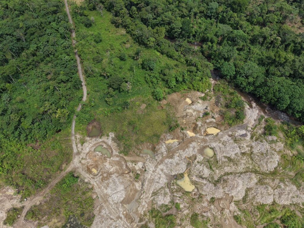
The Kuruaya Indigenous Territory (state of Pará, municipality of Altamira) has experienced gold mining activity since the early 1980s, on the Curuá River, where the villages of the Kuruaya are located. The most intense recent mining has occurred on a tributary of the Curuá River, known as the Madalena.
Since 2023, the Xingu+ Network monitoring has recorded the expansion of illegal gold mining along the Madalena. That year, a formal complaint was filed (via Official Letter 42/2023-Rede Xingu+), which reported the loss of around 3 hectares due to gold mining. In 2024, the activity intensified with the deforestation of another 13.4 hectares, and from January to July 2025, the Madalena mining operation had already expanded by another 17.8 hectares, for a cumulative total of 34.2 hectares.
Figures A1 and A2 show the expansion of the illegal gold mining along the Madalena between 2024 (left panels) and 2025 (right panels). This mining is expanding primarily towards the confluence of the Madalena with the Curuá River. In addition, the activity has spread to new, smaller areas in the surrounding region.
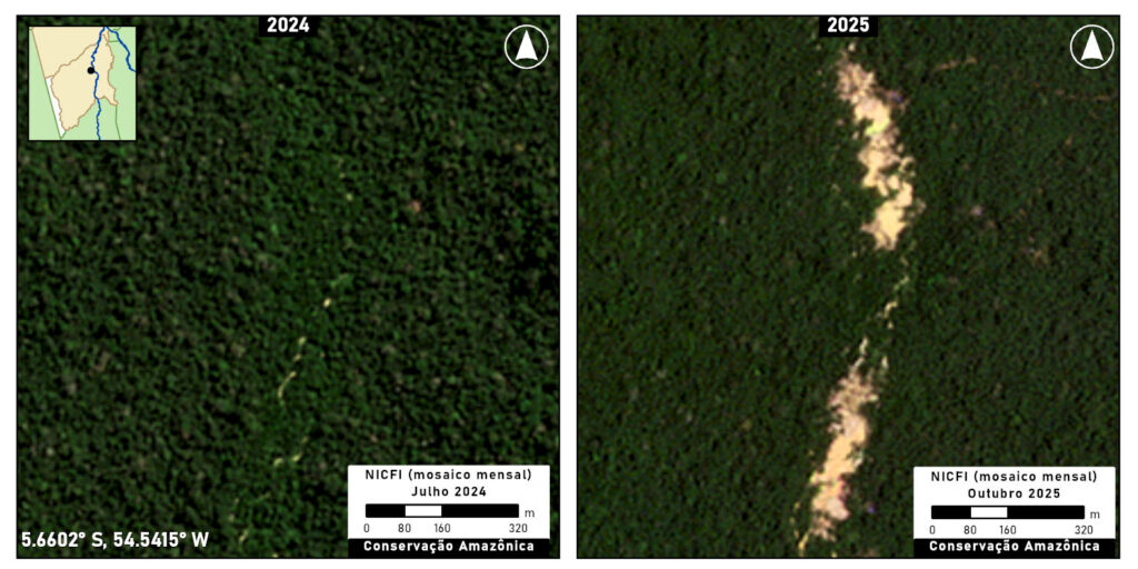
Figure A1. Mining in Kuruaya Indigenous Territory. Data: Planet/NICFI
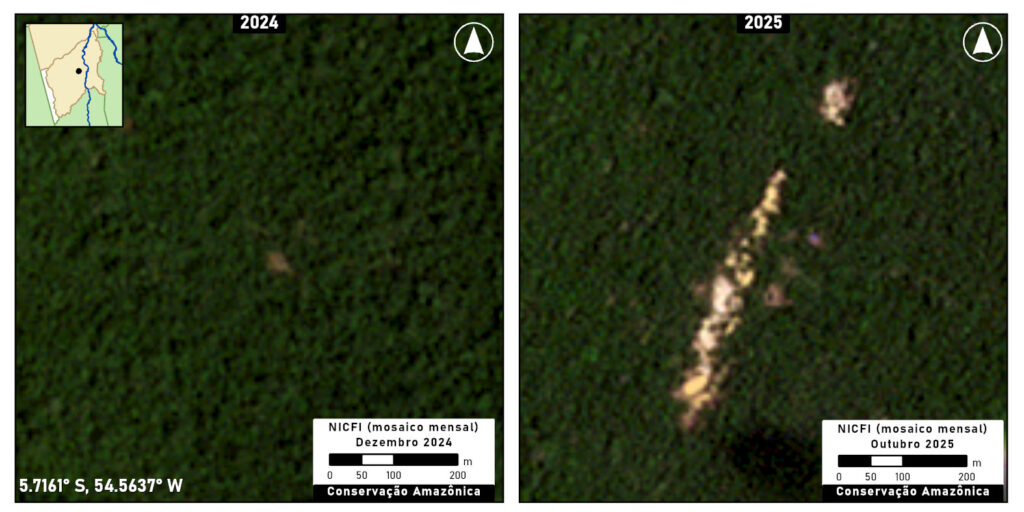
Figure A2. Mining in Kuruaya Indigenous Territory. Data: Planet/NICFI
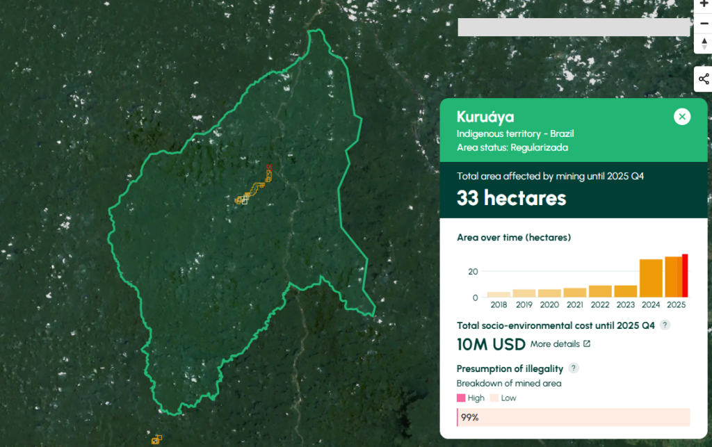
Amazon Mining Watch results for Kuruaya Indigenous Territory.
Amazon Mining Watch indicates the cumulative mining deforestation of 33 hectares in Kuruaya Indigenous Territory, including 4 hectares in 2025 (click here to see on AMW).
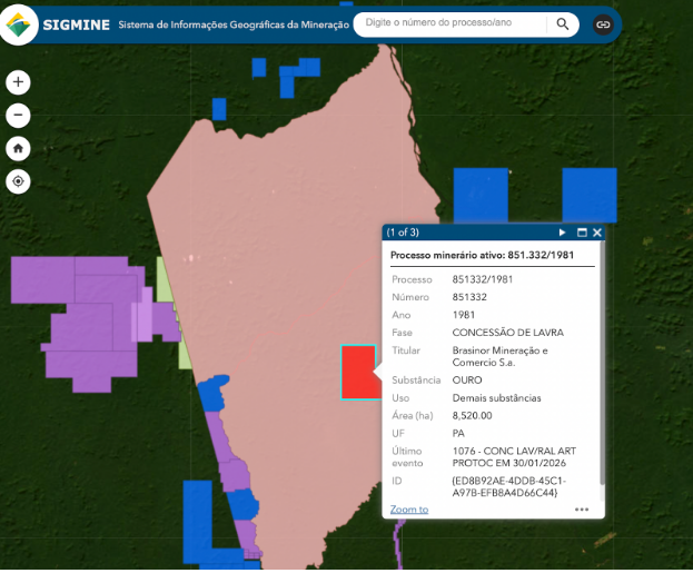
This mining is taking place within an active gold concession registered in the SIGMINE digital cadaster. Per the Brazilian Constitution, however, this type of concession (“lavra garimpeira” or exploitation permit for artisanal mining) is irregular within Indigenous territories (Note 2).
Baú Indigenous Territory
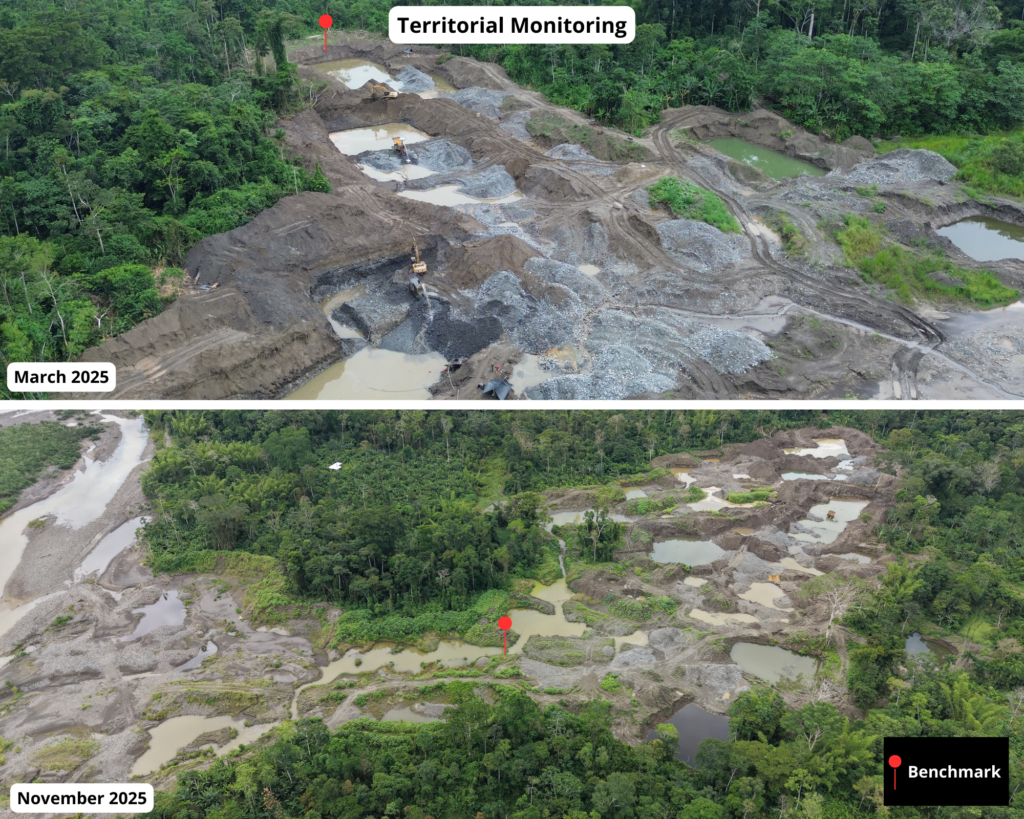
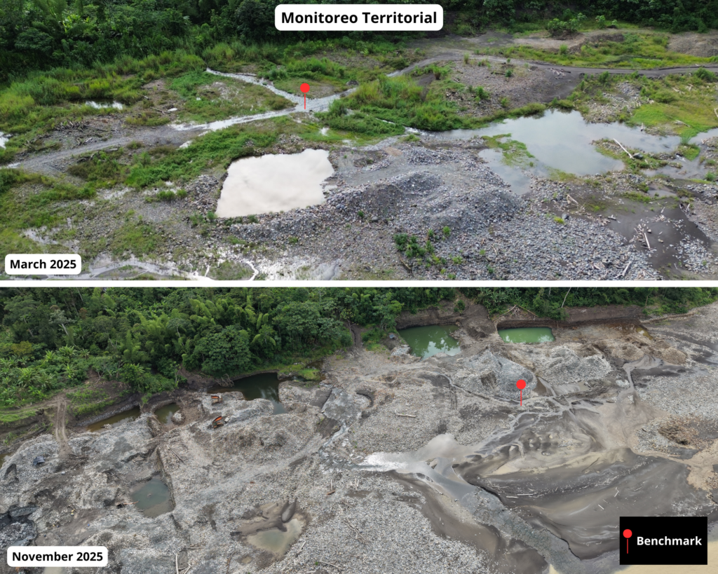
The Baú Indigenous Territory (state of Pará, municipality of Altamira) is inhabited by the Mebengôkre (Kayapó) Mekrãgnoti and isolated Purô peoples across its vast 1.5 million hectares. Illegal mining has impacted this territory since at least 2019, and has been the scene of several armed conflicts between miners and Indigenous members.
In the first half of 2025, active illegal mining sites were detected in several parts of the territory, most notably in the central mining site of Pista Velha. Pista Velha is an old mining site, but it was in 2019 that its reactivation became the scene of several armed conflicts between Indigenous peoples and gold miners, putting the lives of the Kayapó at risk. Efforts to reclaim this gold mine are ongoing and have been reported on numerous times by Rede Xingu+. In July 2025, an overflight confirmed the presence of mining activity in Pista Velha (see photo).

Overflight photo: Pista Velha mining site (Baú Indigenous Territory) on July 19, 2025. Photo: Xingu+ Network.
Figure B illustrates the gold mining expansion at Pista Velha between 2024 (left panel) and 2025 (right panel).
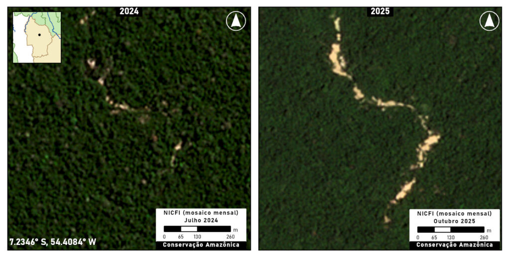
Figure B. Mining in Baú Indigenous Territory. Data: Planet/NICFI
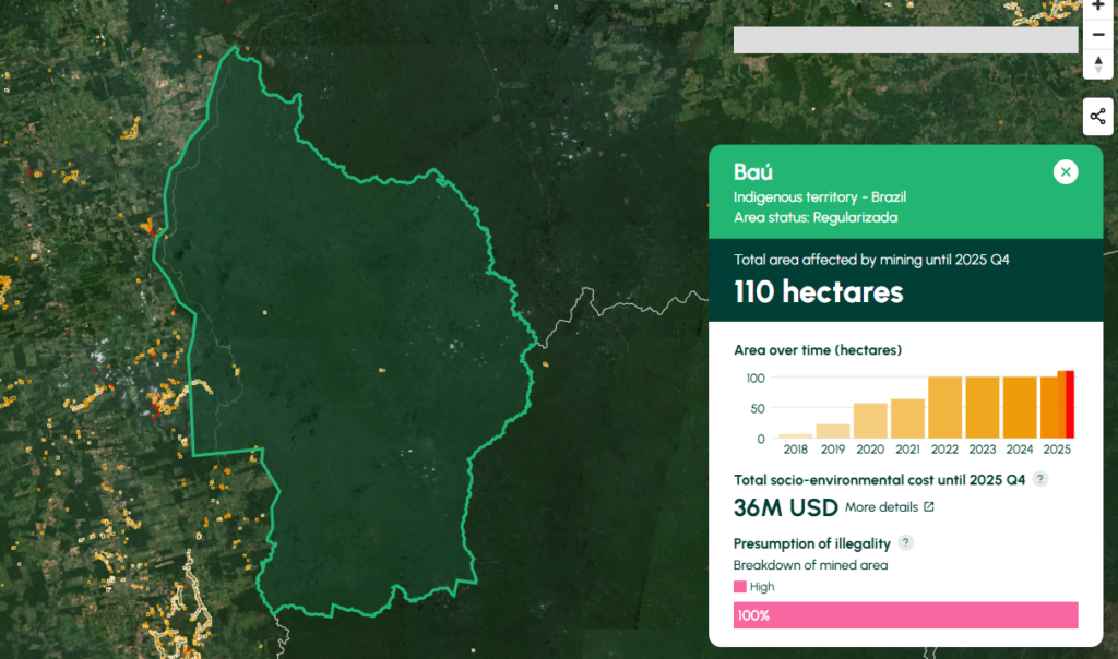
Amazon Mining Watch results for Bau Indigenous Territory.
Amazon Mining Watch indicates the cumulative mining deforestation of 110 hectares in Bau Indigenous Territory, including 10 hectares in 2025 (click here to see on AMW.
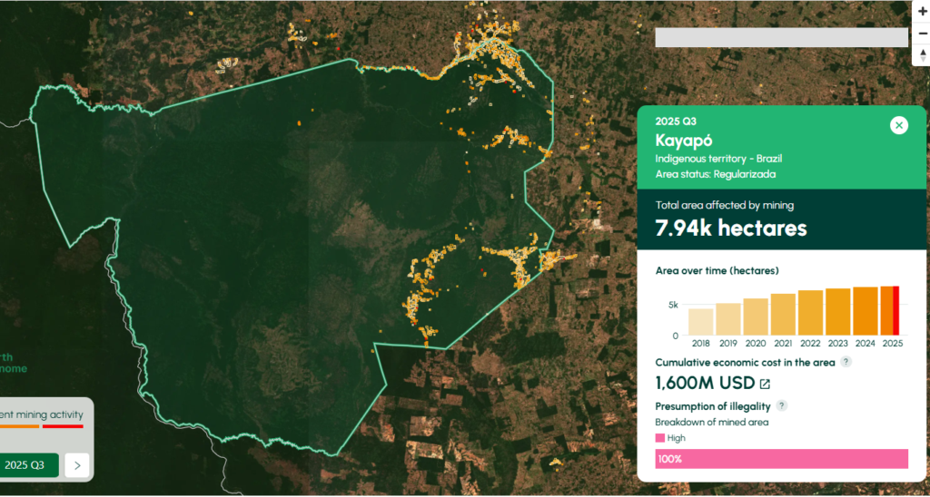
Kayapó Indigenous Territory
The Kayapó Indigenous Territory (state of Pará, across four municipalities) has a long history of illegal mining dating back to the 1960s, and is the territory with the largest area deforested by illegal mining in the Brazilian Amazon.
Government operations to remove illegal miners from the Kayapó Indigenous Territory began in May 2025, in compliance with a Supreme Federal Court ruling (ADP 709), which aims not only to protect Indigenous peoples but also to contain the advance of illegal mining.
The first phase of these operations appears effective, as less than 2 hectares of new mining was detected in June 2025 by SIRAD-X monitoring. However, data from October indicates a small increase in mining in the territory, with an increase of 15 hectares.
Figures C1 and C2 show the recent advance of illegal mining in two locations of Kayapó Indigenous Territory between 2024 (left panels) and 2025 (right panels).
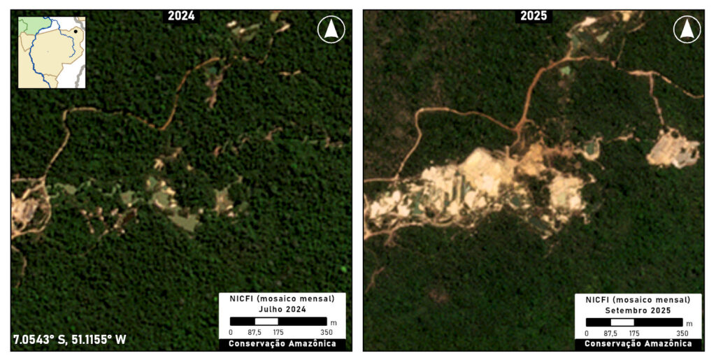
Figure C1. Mining in Kayapó Indigenous Territory. Data: Planet/NICFI
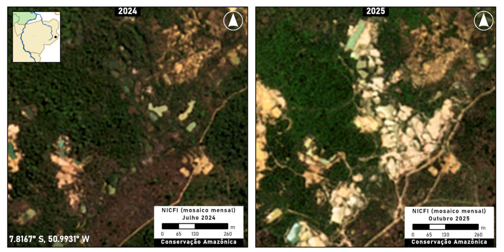
Figure C2. Mining in Kayapó Indigenous Territory. Data: Planet/NICFI
Amazon Mining Watch indicates the cumulative mining deforestation of 7,940 hectares in Kayapo Indigenous Territory, including 140 hectares in 2025 (click here to see on AMW). But much of this increase was detected in the first half of the year, indicating it might be a remnant of the 2024 expansion. Thus, much of that recently detected mining activity by Amazon Mining Watch likely happened in late 2024/early 2025 before the government intervention in May, consistent with the SiRAD X results stated above.
Amazon Mining Watch results for Kayapo Indigenous Territory.
Conclusion and Recommendations
Based on the information presented above, it is clear that illegal mining in the Xingu basin is not an isolated activity. It has spread to both Indigenous territories and protected areas, indicating the existence of a support network that provides the operational capacity and infrastructure necessary for the activity. This expansion brings with it a series of serious risks to the region and its communities.
Illegal mining poses a direct threat to the territorial integrity and well-being of riparian and indigenous communities. The main consequences are the degradation of native areas and the contamination of rivers through the use of mercury. In addition to environmental damage, the expansion of illegal activity increases the risk of socio-environmental conflicts between miners and traditional communities, who seek to protect their territories and way of life.
Below, we propose a number of recommendations to Brazilian authorities with regards to: (i) the design of enforcement actions; (ii) community-based monitoring and restoration (iii) traceability of gold supply chains.
(i) Enforcement actions:
To ensure the long-term protection of indigenous territories from illegal mining, it is crucial to move beyond immediate removal operations and establish a sustainable, preventative framework. While the Brazilian government has initiated removal efforts in response to recent judicial orders, there is a notable absence of a long-term strategy to prevent the recurrence of these invasions. Effective and lasting solutions call for the involvement of various regulatory agencies and strategic interventions that extend beyond the geographical boundaries of the indigenous lands themselves. Therefore, the following policy actions are recommended:
- Establish a permanent, multi-agency task force led by the President’s Chief of Staff (Casa Civil) to develop and implement a comprehensive, five-year strategic plan. This plan should focus on dismantling the external economic and logistical networks that sustain illegal mining, thereby preventing the return of invaders post-removal. The unique convening power of the Casa Civil is essential for orchestrating the necessary collaboration across different government ministries and agencies, ensuring a unified and effective national effort.
- Promote integrated enforcement actions in the areas surrounding the territories to achieve the logistical strangulation of illegal operations. This should involve regulatory agencies alongside environmental enforcement and command-and-control bodies, such as the National Civil Aviation Agency – ANAC (for airfield inspections), the National Petroleum Agency – ANP (for fuel station inspections), and the National Land Transport Agency – ANTT (for road and highway inspections).
- Strengthen agencies responsible for enforcement (IBAMA, ICMBio, and FUNAI) to ensure they have the capacity to operate regularly within the territories highlighted, by meeting their budgetary and personnel requirements.
- Promote the implementation of long-term Protection Plans, guaranteeing a budget for the maintenance of regular enforcement and crime repression actions.
(ii) Community-based monitoring and restoration:
The promotion and strengthening of indigenous surveillance group initiatives for territory monitoring and restoration can complement government-led efforts. An additional benefit of these actions is that they represent sustainable economic alternatives within the territories and thus reduce the vulnerability of youth to recruitment by illegal groups. To this effect, the following actions could be undertaken:
- Support the construction and maintenance of “Surveillance Centers” at strategic points (river confluences, TI boundaries), managed by the communities to ensure the physical occupation of remote areas, that produce relevant information for more effective State action.
- Develop and implement Payment for Environmental Services (PES) schemes for community agents, recognizing territorial surveillance as essential work for biome conservation.
- Strengthen governance actions within the territories by supporting meetings, assemblies, and forums, and promoting the development of management tools such as Territorial and Environmental Management Plans (PGTAs) and Consultation Protocols.
- Promote and finance environmental recovery and decontamination/remediation actions in the most affected areas, in addition to continuous monitoring of mercury levels in the population.
(iii) Traceability of the gold supply chain:
The Brazilian government has already taken some steps to improve the regulation of the gold supply chain and requires the formal registration of the main actors involved in the ASM gold supply chain (such as miners, traders, and exporters). In 2023, it implemented the Electronic Fiscal Invoice for Gold (NF-e ouro), a mandatory document that verifies and records the origin of the mineral.
Nevertheless, additional measures are still necessary to continue to improve gold traceability mechanisms and implement better legislation for the control of mineral production and trade, such as the creation of a digital public portal containing mining titles, licenses, embargoes, and monitored areas, allowing buyers to verify the mining site linked to the Gold NF-e. This would significantly improve traceability for companies and purchasers importing gold from Brazil, thereby promoting a more transparent supply chain.
*Notes
1. Methodology of monitoring systems
For Sirad X monitoring, radar images from the Sentinel-1 satellite are used, which are processed by a series of algorithms on the Google Earth Engine (GEE) platform, along with optical images from the Landsat-9 satellite (OLI-2 sensor) and Sentinel-2 satellite (MSI sensor). A team of analysts examines the monitored area, visually searching for anomalies in the produced images. Each deforestation polygon is evaluated based on its proximity to other areas of degradation and the history of the region, and, if necessary, people familiar with the location are contacted to confirm the deforestation. Field knowledge is fundamental for data validation.
For Amazon Mining Watch, the mine detector is an artificial neural network, which we train to discriminate mines from other terrain by feeding it hand-labeled examples of mines and other key features as they appear in Sentinel-2 satellite imagery. The network operates on square patches of data extracted from the Sentinel-2 L1C data product. Each pixel in the patch captures the light reflected from Earth’s surface in twelve bands of visible and infrared light. We average (median composite) the Sentinel data across a period of many months to reduce the presence of clouds, cloud shadow, and other transitory effects.During run time, the network assesses each patch for signs of recent mining activity, and then the region of interest is shifted by half a patch width for the network to make a subsequent assessment. This process proceeds across the entire region of interest.
2. Mining on Indigenous lands.
 Per the Brazilian Constitution, the concession of “lavra garimpeira” or exploitation permit for artisanal mining is irregular within indigenous territories. (Molina, Luísa Pontes, 2023. Terra rasgada: como avança o garimpo na Amazônia brasileira. Instituto Socioambiental).
In this specific case, the concession, awarded in 1981, predates the approval of the Indigenous Territory Kuruaya in 2001. Following the approval, the concession holder (the firm Brasinor) also submitted a number of concessions for exploration within the territory, which appear to have been rejected. However, a protocol related to the previously active concession was approved by the National Mining Agency on January 30, 2026. The legality of this act, as well as of the concession itself, should be investigated.
A well-established principle in Brazilian law is that Indigenous land rights are effective prior to their formal recognition, thus the fact that the concession predates the approval of the territory is immaterial. If the ANM authorization is found irregular, the constitutional interdiction of mining within indigenous territories should prevail, and the concession be rescinded. A decision from federal courts in 2019 determined that the National Mining Agency must negate any request for exploration or exploitation within indigenous territories, even prior to their approval.
Acknowledgments
This report is part of a series focusing on gold mining in the Amazon, through a strategic collaboration between Amazon Conservation and regional partners, with support from the Gordon and Betty Moore Foundation. In this case, we thank our partner Instituto Socioambiental (ISA) for leading this report.
![]()
![]()
MAAP #238: Gold Mining in the Ecuadorian Amazon, Southern Sector – Morona Santiago Province
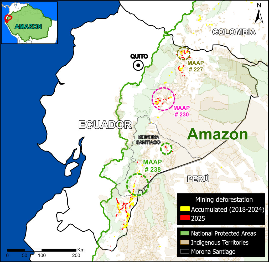
Base Map 1. Mining Deforestation in Ecuador. Data: AMW, Amazon Conservation/MAAP, RAISG
This is the third in a series of reports documenting the expansion of gold mining in the Ecuadorian Amazon.
Previous reports (MAAP #227 and MAAP #230) analyzed the progress of this activity in the northern and central parts of the country, respectively, with a focus on the provinces of Sucumbíos and Napo.
This new report focuses on mining deforestation in the southern Ecuadorian Amazon, in the province of Morona Santiago.
Since 2023, Amazon Conservation, in collaboration with Earth Genome and the Pulitzer Center, has been developing an online geoviewer known as Amazon Mining Watch (MAAP #226). This virtual tool automates the analysis of satellite imagery using machine learning to identify areas affected by mining throughout the Amazon since 2018, and now features quarterly updates for the systematic detection of new gold mining fronts in real time.
Base Map 1 shows the locations of recent confirmed mining-related deforestation using detections from the latest quarterly update of Amazon Mining Watch across the Ecuadorian Amazon, in relation to the cumulative mining impact area (2018-2024). It can be seen that several Indigenous territories converge in the analysis area (purple circles).
Morona Santiago, the second largest province in Ecuador, is one of the country’s main conservation areas and the ancestral home of the Shuar and Achuar Indigenous nationalities. However, it is currently facing a growing threat due to the expansion of gold mining.
Case Studies
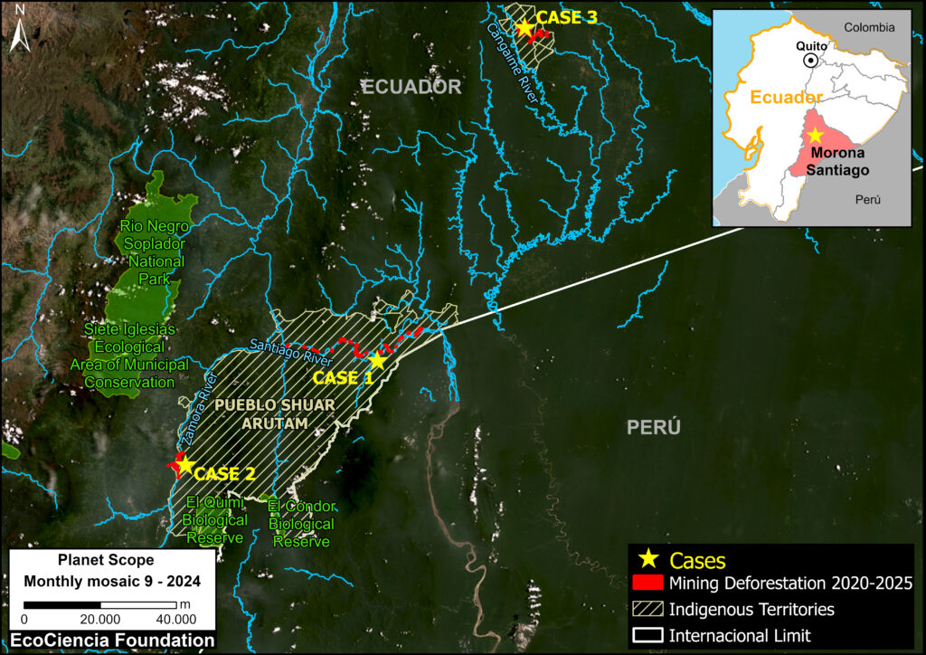
Base Map 2. Satellite monitoring area in Morona Santiago. Data: ACA/MAAP; EcoCiencia; Planet
Cases 1 and 2 focus on mining activities within Shuar Arutam territory (Note 1), in southern Morona Santiago (see Base Map 2).
This territory faces increasing pressure from the expansion of the agricultural frontier, selective logging, and especially mining.
Over half (55%) of the territory is under concession for the extraction of metals such as gold, silver, and copper.
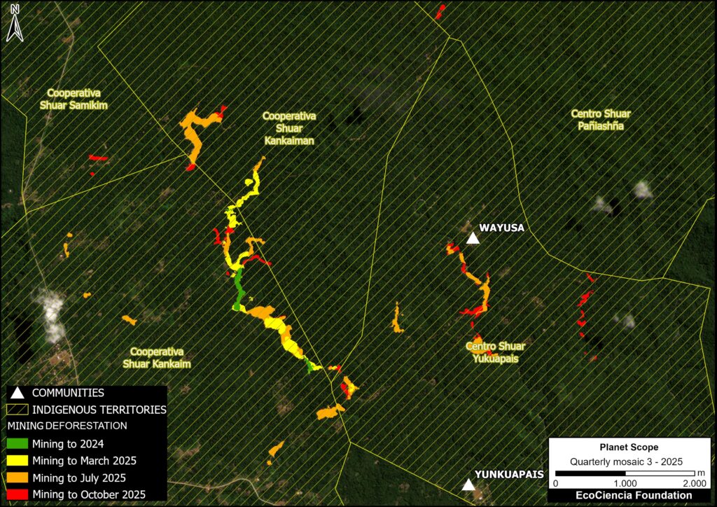
Case 3 focuses on mining in the north of the province; here, illicit mining has been identified within several Shuar territories (Samikim, Kankaiman, KainKaim, Yukuapais, and Pañiashña).
We conducted satellite monitoring aimed at quantifying the impact of illegal gold mining in these three case studies during the period 2020-2025.
Mining Activity in Morona Santiago (2020-2024)
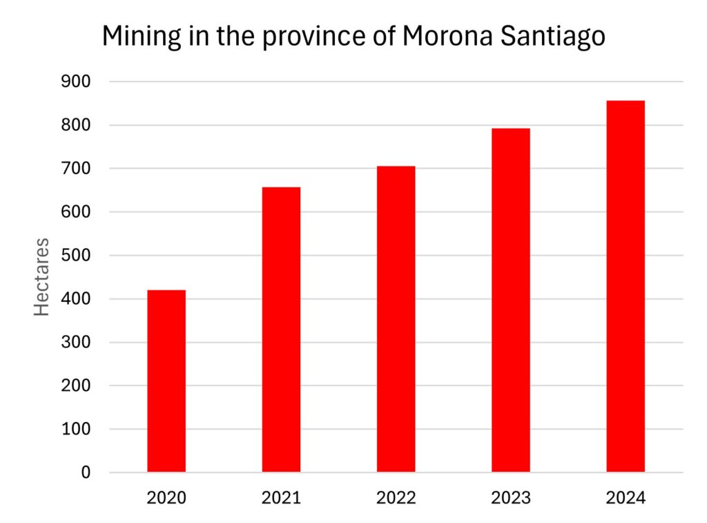
Figure 1. Mining activity in Morona Santiago. Data: MapBiomas; EcoCiencia.
Graph 1 shows the cumulative mining deforestation in the Morona Santiago province between 2020 and 2024.
In 2020, mining impacted around 420 hectares as our baseline. In the subsequent years, we documented a rapid increase, reaching a total of 856 hectares (2,115 acres) by 2024.
This represents a doubling of the affected area in just four years.
Case 1. Santiago River
Case 1. Data: EcoCiencia, Planet
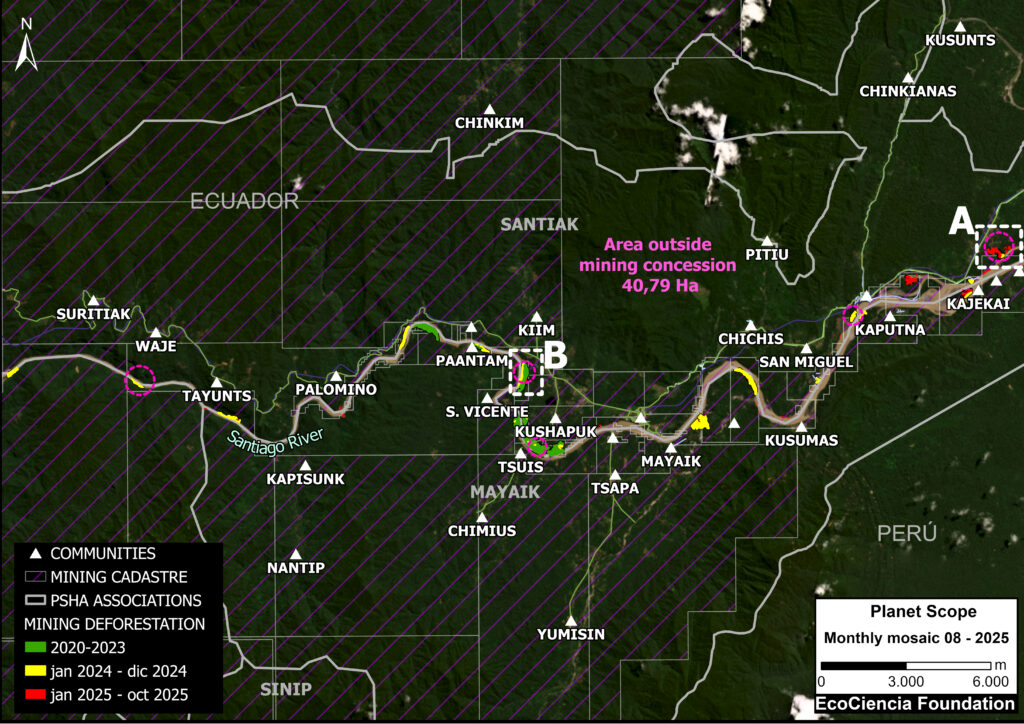
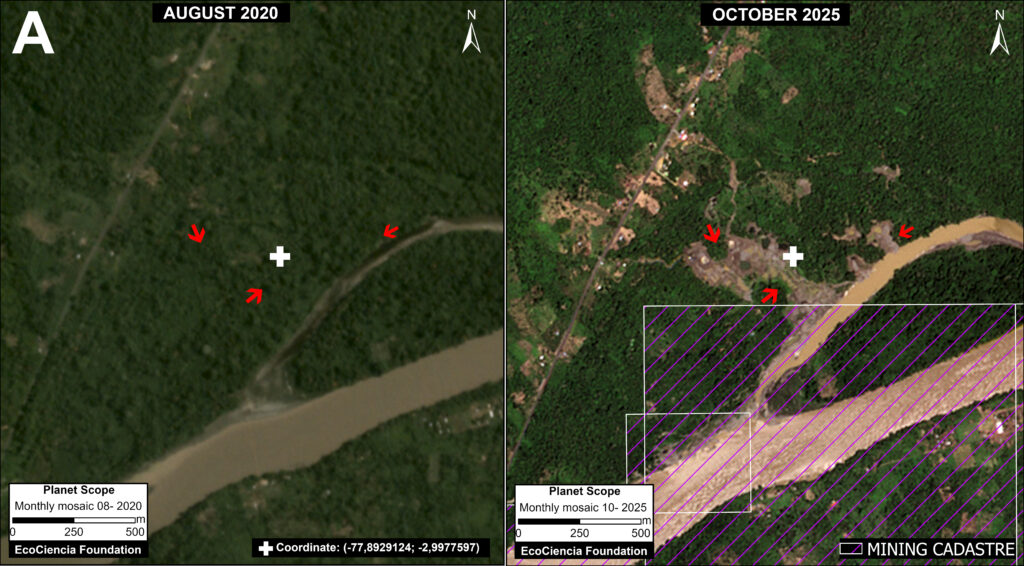
This case is located along the Santiago River (see Case 1 in Base Map 2), between the Shuar Santiak, Mayaik, and Nunkui associations in the territory of the Shuar Arutam (see Note 2)
This river is among the most threatened areas in the territory, especially due to the expansion of mining.
In this area, we detected the mining deforestation of 197 hectares (486 acres) between January 2020 and October 2025.
Of this total, we estimate that 20% (41 hectares; 101 acres) is likely illegal, occurring outside areas authorized for mining activity
We selected two focal areas, both with recent mining impacts, along the Santiago River (see Areas A and B in Case 1).
Panel 1 illustrates the situation in Area A, comparing mining deforestation (as well as the expansion of access roads and the impact on the river) between August 2020 (left panel) and October 2025 (right panel). Of this total forest loss, we confirmed that 12 hectares (30 acres) were located outside of authorized concessions and therefore likely illegal.
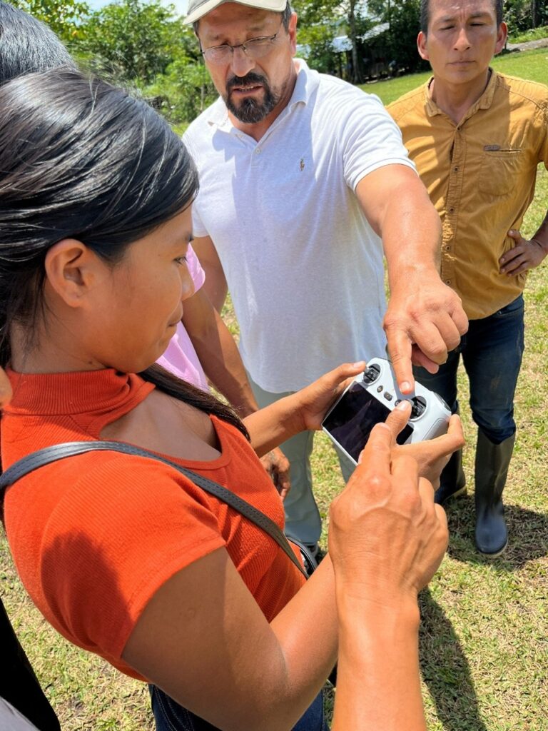
In the Annex, Panel 2 shows an example of the territorial monitoring carried out by the Shuar Arutam using drones.
Panel 1 (Area A). Data: EcoCiencia, Planet
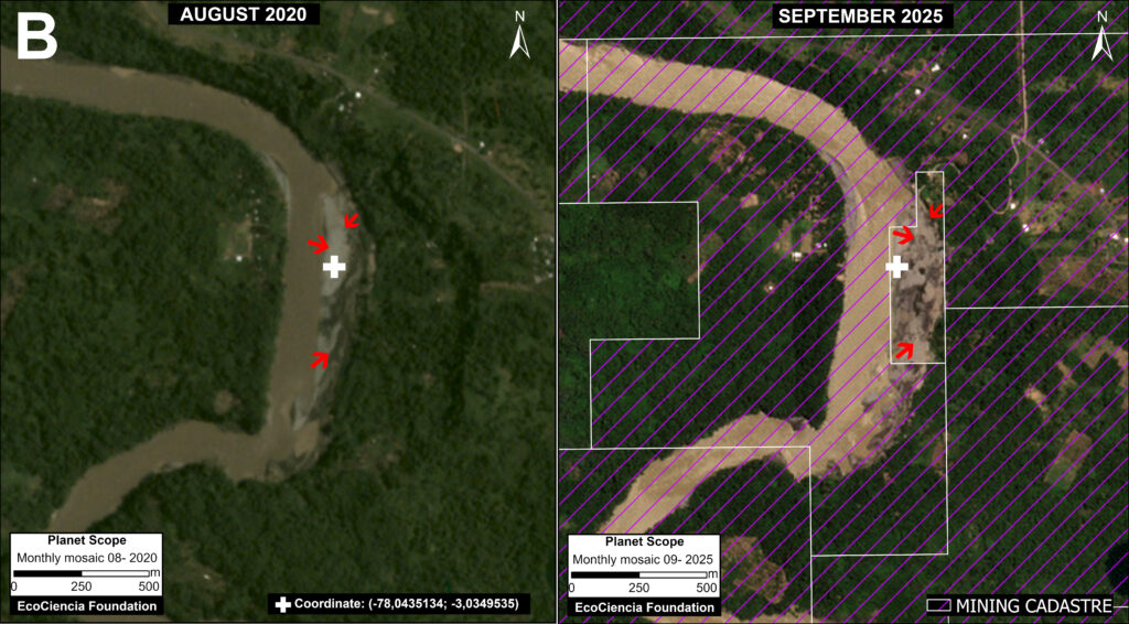
Panel 3 illustrates the situation in Area B, comparing mining deforestation (and impact to the river) between August 2020 (left panel) and September 2025 (right panel). Of this total forest loss, we confirmed that 9 hectares (22 acres) were located outside of authorized concessions and therefore likely illegal.
In the Annex, Panel 4 shows an example of the territorial monitoring carried out by the Shuar Arutam using drones.
Panel 3 (Area B). Data: EcoCiencia, Planet
Case 2. Nayap
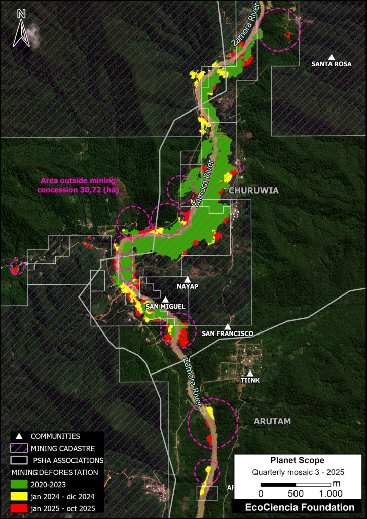
Case 2. Data: Ecociencia
This case is located along the Zamora River (see Case 2 in Base Map 2), on the western edge of the Churuwia association, near the Shuar Arutam community of Nayap. This territory is traditionally inhabited by Shuar communities.
In this area, we detected the mining deforestation of 164 hectares (405 acres) between January 2020 and October 2025.
Of this total, we estimate that 20% (31 hectares; 76 acres) is likely illegal, occurring outside areas authorized for mining activity
Panel 5 illustrates the situation in Case 2, comparing mining deforestation (and impact to the river) between January 2020 (left panel) and September 2025 (right panel).
Panel 5. Data: EcoCiencia, Planet
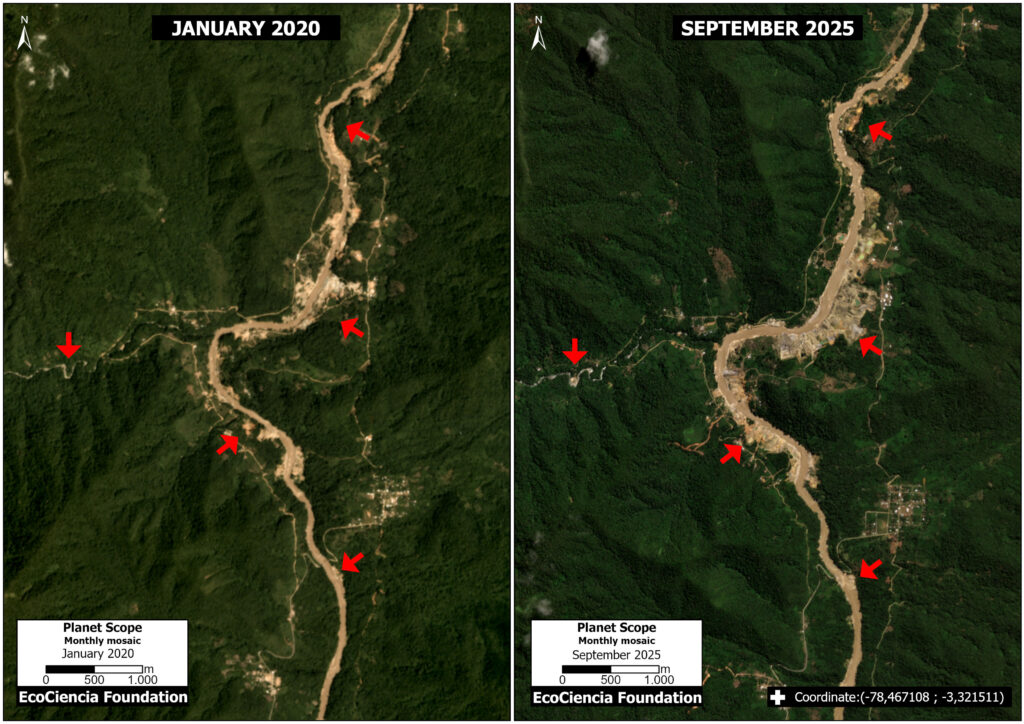
Case 3. Taisha
This case is located in the northern part of Morona Santiago (see Case 3 in Base Map 2), within the Shuar Indigenous territories of Samikim, Kankaiman, Kainkaim, Yukuapais, and Pañiashña.
In this area, we detected the mining deforestation of 100 hectares (247 acres) between October 2024 and October 2025 (see Case 3).
Case 3. Data: ACA/MAAP; EcoCiencia, Planet
Panel 6 illustrates the situation in Case 3, comparing mining deforestation (and road expansion) between October 2024 (left panel) and October 2025 (right panel). The opening of these roads facilitates direct access for machinery, personnel, and supplies to previously inaccessible areas, increasing connectivity and accelerating the occupation of the territory.
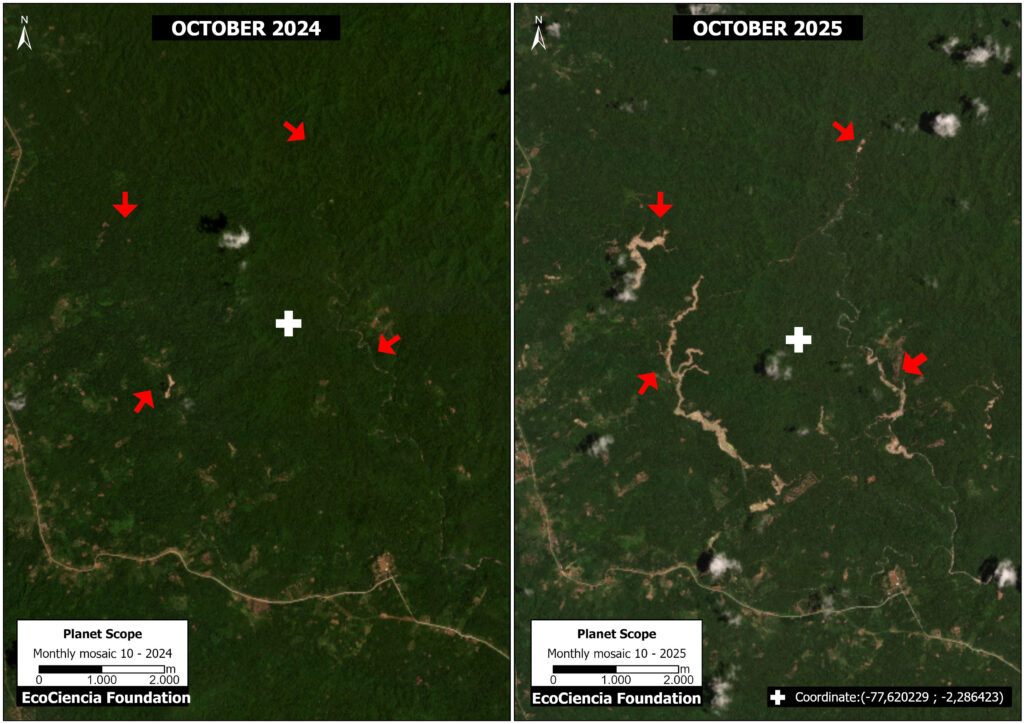
Panel 6. Data: EcoCiencia, Planet
Policy recommendations
1. Strengthening Indigenous governance
Fundación EcoCiencia.
The cases analyzed show that, while Ecuadorian law broadly recognizes the right to citizen participation and the collective rights of indigenous peoples and nationalities in environmental and mining decisions, its implementation faces significant challenges. The legal framework distinguishes between environmental consultation as a diffuse right and prior, free, and informed consultation as a collective right, regulated by the Mining Law, the Organic Environmental Code, the Organic Law on Citizen Participation, and recent secondary legislation. However, the historical absence of a specific law and the gaps in the practical application of these mechanisms have generated tensions and questions regarding the quality of intercultural dialogue, effective access to information, and the real influence of communities in decision-making.
While the Escazú Agreement strengthens the Ecuadorian state’s obligations regarding environmental participation, access to information, and environmental justice, the cases reviewed show that these standards do not always translate into substantive processes that strengthen indigenous territorial governance. In particular, prior consultation is often conducted in isolation from permanent community-based monitoring and oversight mechanisms, which limits communities’ ability to continuously monitor extractive activities affecting their territories.
In this context, to strengthen indigenous governance, it is recommended to formally recognize indigenous monitors as legitimate actors within environmental monitoring and control processes, coordinating their work with existing institutional mechanisms. Additionally, it is proposed to implement a permanent satellite monitoring system integrated with community observation systems, allowing for the early detection of road construction and other illegal activities, and contributing to the realization of the principles of effective participation and intercultural dialogue.
2. Biocultural territorial planning
Fundación EcoCiencia.
The Constitution of Ecuador recognises interculturalism and plurinationality (articles 1 and 250), as well as the legal systems of indigenous peoples; similarly, the Escazú Agreement (article 7) promotes inclusive participation with intercultural approaches.
Within this framework, it is recommended to adopt a biocultural territorial planning approach that integrates indigenous life plans and governance systems as binding instruments in public decision-making.
No mining project can be approved without first being integrated into these local instruments, which are developed through community assemblies.
3. Controlling road expansion in Indigenous territories
Fundación EcoCiencia.
The development of a road in the Ecuadorian Amazon involves a series of fundamental environmental requirements, established in the national regulations in force as of 2025, to guarantee the protection of the environment, biodiversity, and the rights of local and indigenous communities.
These requirements are regulated primarily by the Organic Environmental Code (COA) and its Regulations (issued through Executive Decree 752 and subsequent amendments), the jurisprudence of the Constitutional Court of Ecuador regarding environmental rights and the rights of Nature; and international human rights treaties such as the Escazú Agreement (in force in Ecuador since 2021).
We recommend requiring a Strategic Environmental Assessment (SEA) for all road projects in areas of high ecological sensitivity, especially in indigenous territories and protected areas.
The construction of roads without an environmental impact assessment and without applying the precautionary principle should be considered illegal and subject to reversal, prioritizing ecological restoration processes with the participation of local communities.
Notes
(1) Located in the Cordillera del Cóndor, between the Zamora and Yaupi rivers, the Shuar Arutam community is part of the Abiseo–Cóndor–Kutukú bio-corridor, an ecological bridge that connects the Tropical Andes biodiversity hotspot with one of the largest continuous wilderness areas of the Amazon rainforest. This mountain range protects areas of high biological importance, safeguards water sources, and harbors habitats of endemic species. Furthermore, it constitutes the ancestral territory of the Shuar people, where sacred sites preserve their spiritual and collective memory.
(2) The Santiago River flows through the Abiseo–Cóndor–Kutukú bio-corridor, one of the main biodiversity hotspots in the Ecuadorian Amazon (CARE et al., 2012), characterized by highly diverse ecosystems and the presence of numerous terrestrial and aquatic species (Schulenberg & Awbrey, 1997). Recent research even suggests that the river’s unique environmental conditions may be promoting speciation processes in fish due to its natural isolation (Provenzano & Barriga, 2018). In addition to mining, threats include hydroelectric projects, deforestation, overfishing, and the introduction of invasive species, which generate increasing pressures that degrade its ecosystems and severely affect native species.
Annex
Panels 2 and 4 highlight the territorial monitoring carried out by the Shuar Arutam using drones.
Panel 2 shows the expansion of mining deforestation between May (top panel) and November (bottom panel) of 2025.
Panel 2 (Area A). Data: Fundación EcoCiencia.
Panel 4 shows the expansion of mining impact between March (top panel) and November (bottom panel) of 2025, including more extensive excavation fronts and a greater accumulation of sediment.
Panel 4 (Area B). Data: Fundación EcoCiencia.
Citation
Villa J, García C, Barriga J, Finer M, Josse C, Aguilar C (2025). Minería en la Amazonía Ecuatoriana Sector Sur – Provincia de Morona Santiago. MAAP: 238.
Acknowledgments
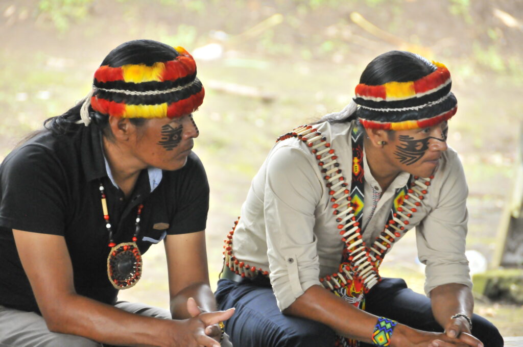
We thank the Shuar Arutam for their contributions to this report.
This report is part of a series focused on the Ecuadorian Amazon through a strategic collaboration between the organizations EcoCiencia Foundation and Amazon Conservation, with the support of the Gordon and Betty Moore Foundation.

![]()
MAAP #235: AI-powered detection of Amazon gold mining deforestation in real-time

Screen shot from the updated Amazon Mining Watch site.
As gold prices continue to skyrocket and shatter historical records, small-scale, but widespread, gold mining activity also continues to be one of the major deforestation drivers across the Amazon.
In collaboration with its network of partners in the region, MAAP has produced many reports documenting the expansion of gold mining across the Amazon over the years, highlighting often previously undocumented cases (see archive).
Given the vastness of the Amazon, however, it has been a challenge to systematically detect all new mining fronts in real-time. Such a timely and comprehensive system is crucial to ensure that monitoring can be the basis for a swift and consistent enforcement response from authorities.
Since 2023, Amazon Conservation, in partnership with Earth Genome and the Pulitzer Center, has been developing an online dashboard known as Amazon Mining Watch (MAAP #226). This online tool automates the analysis of satellite imagery through machine learning to identify areas affected by mining across the entire Amazon, from 2018 to 2024.
In a major advance, we are glad to announce that Amazon Mining Watch (AMW) will now move to quarterly updates for this data, achieving systematic near-real-time detection of new artisanal gold mining fronts across the region.
Additional functionalities have been added to the AMW that will enhance the analysis related to illegal gold mining in the biome, namely: an analysis of the legality of mining sites, and an economic valuation of the social and environmental damage through the mining impacts calculator tool (see Annex).
FIRST QUARTERLY UPDATE REPORT: MINING EXPANSION ACROSS THE AMAZON
Here, we present our first quarterly update report based on this fresh data for quarters 2 and 3 of 2025 (April-September 2025). The following Base Map shows the locations of recent (Q3 of 2025) mining deforestation across the Amazon, in relation to the cumulative mining impact area previously detected.
Key findings from the first quarterly updates include:
- We confirm the recent expansion of gold mining in all nine countries of the Amazon (37,109 hectares in 2025).
- Brazil registered the largest recent mining expansion area (15,538 ha in 2025), followed by Peru (6,511 ha) and Guyana (4,942 ha).
In addition, Venezuela, Suriname, Ecuador, and Bolivia all had over 2,000 hectares of recent impact. - Guyana and Suriname have the largest area of mining-related deforestation relative to their size.
- The total area of gold mining expansion in the second quarter of 2025 represents over 19,000 hectares
- Mining expansion accelerated in the third quarter (July-Sept) of 2025, with over 17,000 hectares of forest lost to mining, almost twice the rate observed in the first half of the year.
- Despite experiencing relatively widespread river-based mining, Colombia is the only country in the region that had been so far mostly spared from the impacts of gold mining on land (also referred to as “alluvial mining”). The recent crossing of alluvial mining along the Rio Puré from Brazil into Colombia, further described below, could put an end to this exception and explains almost single-handedly the sharp uptick seen in the last quarter (+58%).
- In 2025, over 200 (222) protected areas and Indigenous territories experienced new mining activity, and therefore likely to represent illegal mining. The estimated mined area of these 2025 mining events is over 14,000 hectares (14,004 ha). Of this total, 56% occurred in protected areas, and 44% in Indigenous territories.

CASES OF RECENT GOLD MINING DEFORESTATION ACROSS THE AMAZON

Base Map. Amazon gold mining deforestation highlighted cases Data: AMW, ACA/MAAP.
The Base Map shows the locations of confirmed recent (Q3 of 2025) mining deforestation across the Amazon, in relation to the cumulative mining impact area.
In each set of panels displayed below, we show high-resolution satellite imagery before (left panel) vs after (right panel) the recent gold mining deforestation. The red polygons indicate the pixels highlighted by the AI model as a new quarter 3 mining deforestation event. Yellow polygons are previously detected pixels.
A. Rio Puré, Colombia-Brazil border
The Q3 2025 detection revealed that alluvial gold mining has, for the first time, crossed the border between Brazil and Colombia, into the Rio Puré National Park. A relatively large-scale operation appears to be ongoing and expanding in one of the most remote corners of the Amazon, affecting one of the largest intact forest landscapes still remaining globally.
Mining along the Rio Puré is estimated to have started around 2018, gradually expanding along the whole Brazilian portion of the river between the border with Colombia and where it meets the Japurá river, itself one of the major tributaries of the Amazon river. The clear difference in the river’s color between the last two quarters also reveals the amount of sediments released from the mining operation, which greatly increased water turbidity.
The verified expansion of the mining into the Colombian side, under National Park status, makes this a clear case for transboundary collaboration between the enforcement authorities of Brazil and Colombia. This incursion from Brazil represents the vast majority of mining-related deforestation in the country for the last quarter, and an almost 60% increase in area compared to the previous 7 years.
This case registers as a Very High probability of being illegal based on the legality layer. For more information, consult the scene on Amazon Mining Watch.

B. Northern Ecuador
Figure B shows the recent mining deforestation outside of the Cofán Bermejo Ecological Reserve in the northern Ecuadorian Amazon. This area has experienced increasing mining impact in recent years, as further described in MAAP #227. Note that this mining activity is within the Puma Kucha, Indigenous territory. This case registers as a High probability of being illegal based on the legality layer. For more information, consult the scene on Amazon Mining Watch.

C. San José de Karene Indigenous Territory, Peru
Figure C shows the recent mining deforestation in the San José de Karene Indigenous Territory in the southern Peruvian Amazon. As detailed in MAAP #208, much of the illegal mining deforestation in the southern Peruvian Amazon is occurring within the territory of Native Communities. This case registers as a High probability of being illegal based on the legality layer. For more information, consult the scene on Amazon Mining Watch.

D. Pemon Indigenous Territory, Venezuela
The Pemon Indigenous territory stands out as the area most affected by gold mining in the last quarter, across all protected areas and indigenous territories of the region. The Pemon’s traditional territory is divided between an officially demarcated area, where mining increased by more than 100 hectares in the last quarter, and a much greater and yet-to-be-demarcated area, where mining increased by a staggering 700 ha in the last quarter only, a steep acceleration from the first semester of 2025. The Pemon’s territory encompasses part of the outstanding geological wonder Mount Roraima, a flat-topped mountain of immense cultural significance to local peoples. Mount Roraima harbors unique biodiversity and inspired Michael Crichton’s novel “The Lost World”.
This case registers as a High probability of being illegal based on the legality layer. For more information, consult the scene on the Amazon Mining Watch.

Brazil
Figure E shows the recent mining deforestation in the Amapá State Forest in the northeastern Brazilian Amazon. The forest is managed to benefit local communities through initiatives like sustainable agroecology and improved management of wood and non-forest products. This marks the first time this area has been highlighted by MAAP. This case registers as a Very High probability of being illegal based on the legality layer. For more information, consult the scene on the Amazon Mining Watch.

Figure F shows the recent mining deforestation in the Tapajós Environmental Protection Area in the central Brazilian Amazon. It is in the western portion of the BR-163 Sustainable Forest District. As noted in MAAP #226, Tapajós EPA is one of the Amazon’s top ten most impacted protected areas (in terms of accumulated footprint), including high levels of new mining deforestation in 2024. This case registers as a Very High probability of being illegal based on the legality layer. For more information, consult the scene on the Amazon Mining Watch.

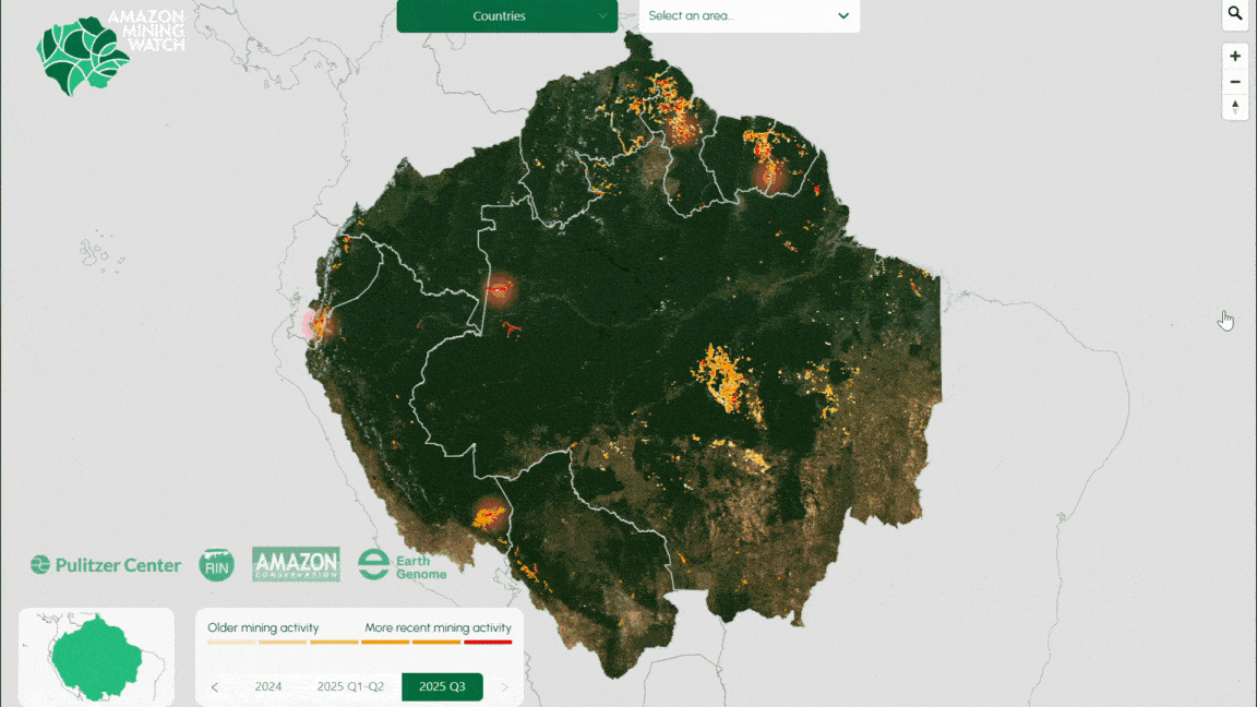
Figure G shows the recent mining deforestation in Jamanxim National Forest in the central Brazilian Amazon. As noted in MAAP #226, Jamanxim NF is one of the Amazon’s top ten most impacted protected areas (in terms of accumulated footprint). This case registers as a Very High probability of being illegal based on the legality layer. For more information, consult the scene on the Amazon Mining Watch.

Figure H shows the recent mining deforestation in the Grão-Pará Ecological Station in the northeast Brazilian Amazon, along the border with Guyana. It is the largest strictly protected tropical forest research station in the world. This marks the first time this area has been highlighted by MAAP. This case registers as a Very High probability of being illegal based on the legality layer. For more information, consult the scene on the Amazon Mining Watch.

Suriname
Figure I show recent mining deforestation in northeast Suriname. This marks the first time this specific area has been highlighted by MAAP. This case registers as a High probability of being illegal based on the legality layer. For more information, consult the scene on the Amazon Mining Watch.

Guyana
Figure J shows the recent mining deforestation in northwestern Guyana, near the border with Venezuela. This marks the first time this specific area has been highlighted by MAAP. For more information, consult the scene on the Amazon Mining Watch.

Annex
New functionality: Legality of mining sites
Based on an analysis of potential overlaps with land designations and applicable regulations, a location-based presumption of illegality of mining operations was incorporated into the AMW. We classified the presumption of illegality from very high to low, using the following descriptions:
- Very High: Activity is occurring without a permit and within a protected area that doesn’t allow for any kind of resource exploitation
- High: Activity if occurring outside of any explicit concession for doing so
- Medium: Activity is happening within a concession, but active status could not be verified and/or concession doesn’t meet legal requirements
- Low: Activity is happening within active concession, but compliance with all requirements could not be verified
This functionality is available for 5 countries: Bolivia, Brazil, Colombia, Ecuador and Peru, and will be extended to the rest of Amazonian countries in 2026. Based on national datasets of land designations, it provides an immediate overview of the likelihood of illegality of ASM in any area of analysis.
New functionality: Mining impacts calculator
The Mining Impacts Calculator, developed by Conservation Strategy Fund, is a tool to assess the social and environmental damage caused by gold mining. The tool uses an economic formula to estimate effects on the environment and society by inputting variables such as the size of the mine, the amount of gold produced and the time of extraction. The automated formula uses average mining productivity and data-driven impact parameters to deliver contextualized data to the user.
The calculator can be used for three main purposes: to estimate social and environmental damage values to calculate the amount of financial compensation needed to mitigate the costs, to estimate the most efficient investment amounts for future impact planning and the prevention of negative impacts, and to estimate the recommended amount of investment in mercury-free technologies needed.
Notes/Methodology
Note that in this report, we focus on mining activity that causes deforestation. The vast majority is artisanal or small-scale gold mining, but other mining activities have also been detected, such as iron, aluminum, and nickel mines in Brazil and Colombia. Additional critical gold mining areas in rivers that are not yet causing deforestation (such as in northern Peru (MAAP #233), southeast Colombia (MAAP #228), and northwest Brazil (MAAP #197), are not included in this report. This information is not yet displayed in Amazon Mining Watch, but future updates will include river-based mining hotspots.
Our data source for protected areas and Indigenous territories is from RAISG (Amazon Network of Georeferenced Socio-Environmental Information), a consortium of civil society organizations in the Amazon countries. This source (accessed in December 2024) contains spatial data for 5,943 protected areas and Indigenous territories, covering 414.9 million hectares across the Amazon.
Amazon Mining Watch (AMW) is a partnership between Earth Genome, the Pulitzer Center’s Rainforest Investigations Network, and Amazon Conservation. The algorithm is based on 10-meter-resolution imagery from the European Space Agency’s Sentinel-2 satellite and produces 480-meter resolution pixelated mining deforestation alerts. Although the data is not designed for precise area measurements, it can be used to give timely estimates needed for management and conservation purposes.
Acknowledgments
This report was made possible by the generous support of the Gordon and Betty Moore Foundation.
![]()
MAAP #227: Gold Mining in the Ecuadorian Amazon – Northern Sector
Base Map. Gold mining deforestation in the Ecuadorian Amazon. Data: Amazon Mining Watch, RAISG
In a recent report (MAAP #226), we presented data from Amazon Mining Watch (AMW), a collaboration between Amazon Conservation, Earth Genome, and the Pulitzer Center. This public resource uses AI (artificial intelligence) to detect gold mining deforestation across the Amazon, starting in 2018.
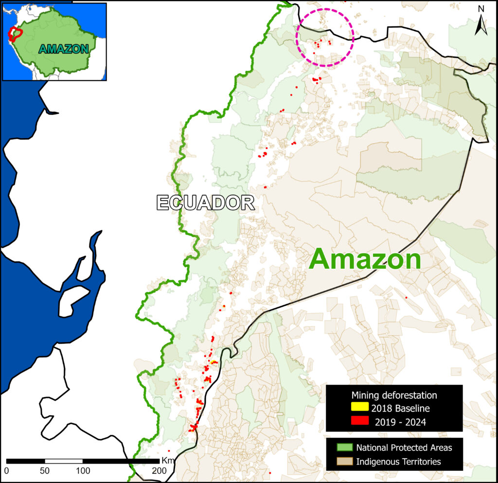
The Base Map illustrates the current data, highlighting the most recent mining deforestation (2019–2024) in red. Note the concentration of new mining activity in the western part of the Ecuadorian Amazon, along the transition with the Andes Mountains.
This is the first in a series of reports detailing gold mining in these areas. In this report, we focus on deforestation due to mining in the northern sector, around the Cofán Bermejo Ecological Reserve.
The Cofán Bermejo Ecological Reserve was one of the best-preserved protected areas in the province of Sucumbios until approximately 2020. In recent years, a rapid expansion of gold mining has been unfolding in the buffer zone of the southeastern edge of the reserve.
The vast majority of this activity has been identified as illegal mining, as it occurs outside designated mining areas, or is carried out in concession areas without proper authorization. The expansion of illegal gold mining in this sector is promoted by criminal groups located on the border with Colombia (Note 1).
Mining in the Ecuadorian Amazon – Northern Sector
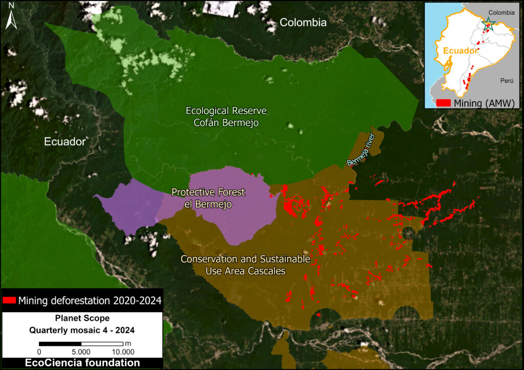
Figure 1. Mining to the southeast of Cofán-Bermejo Ecological Reserve. Data: AMW, ACA/MAAP; MAATE; NCI, Planet.
In a previous report, MAAP #186 analyzed mining activity just outside Cofán Bermejo Ecological Reserve, located in the northern Ecuadorian Amazon, in the province of Sucumbíos. Here, we update and expand this analysis around the reserve.
This expanded analysis incorporates additional conservation areas, such as El Bermejo Protective Forest and the Cascales Municipal Conservation and Sustainable Use Area (see Figure 1), as well as Shuar and Kichwa Indigenous territories (Figure 2).
Due to the development of this mining activity in several different land designation areas, it is worth emphasizing that there are two major factors determining its legality or illegality in Ecuador:
1) Express prohibition provided for by the Constitution or law, as in the case of metal mining activities in protected areas (Article 407 of the Constitution) or the prohibition on the use of mercury in mining operations (Article 86.1 of the Mining Law).
2) Lack of authorization, such as conducting exploration and exploitation activities without the corresponding permits.
In terms of social impact, Mongabay Latam (2023) contextualizes this area (References 1-2): “Indigenous communities and social and environmental organizations that work in the territory cannot openly denounce what is happening in this border area with Colombia, due to the presence of armed groups and the serious security problems that exist there.”
Considering that the largest area of gold mining deforestation is located in the Cascales Conservation and Sustainable Use Area (Figure 1), it is important to note that this type of designation (Conservation and Sustainable Use Areas) are zones created by decentralized autonomous local governments, communities, or private landowners to conserve biodiversity and develop sustainable activities that maintain ecosystem services beneficial to human life. Activities such as conservation, research, restoration, education, culture, recreation, and tourism, as well as sustainable subsistence production activities, can be carried out in these protected areas. The declaration of these protected areas does not modify mining concessions granted by the National Environmental Authority that remain in force and may be renewed, as long as they are compatible with sustainable use.
Regarding El Bermejo Protective Forest, this designation type (Protective Forest) is natural vegetation formations (trees, shrubs, or herbs) found in areas with rugged topography, headwaters of watersheds, or zones unsuitable for agriculture or livestock farming. Their primary function is to conserve water, soil, flora, and wildlife. Activities permitted in these forests, with authorization from the National Environmental Authority, include the promotion of wildlife, the execution of priority public works, sustainable forest management, and scientific, tourism, and recreational activities.
Indigenous Territories
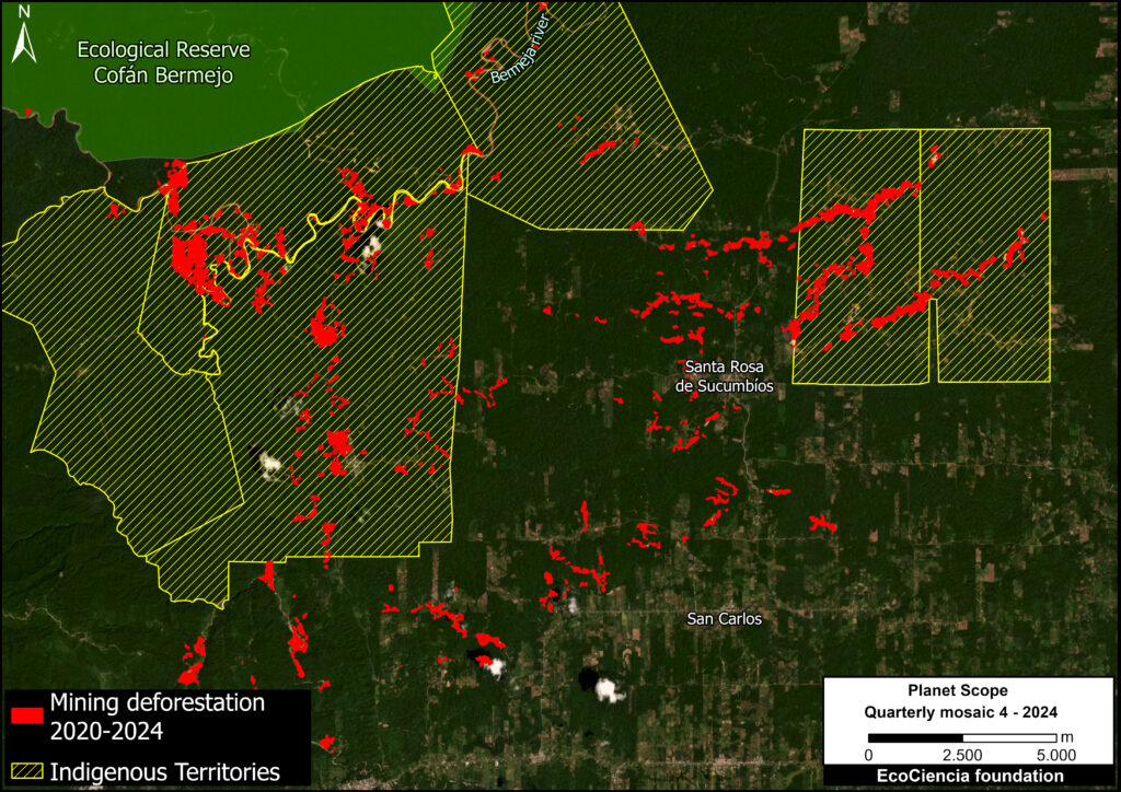
Figure 2. Gold mining deforestation in Indigenous territories (Shuar & Kichwa). Data: ACA/MAAP; EcoCiencia; Planet
In addition to the Cofán Bermejo Indigenous Territory, which shares boundaries with the Ecological Reserve of the same name, gold mining deforestation threatens six surrounding Shuar and Kichwa Indigenous territories (Figure 2).
Note that these territories overlap with the conservation areas noted above.
In total, 68% of the mining deforestation detected in the study area was identified as occurring within these Indigenous territories.
Increase in Gold Mining Deforestation 2020 – 2024
Using satellite imagery (Planet), we estimated the annual expansion of gold mining deforestation in this area between 2020 and 2024. The total forest area affected by mining by the end of 2024 is approximately 754 hectares, equivalent to 1,863 acres.
The vast majority of this mining occurred in the Cascales Conservation and Sustainable Use Area or Indigenous territories.
The analysis shows that the largest increase occurred in 2024, with an expansion of 189.62 hectares. Overall, we documented a trend of continual accumulated expansion of gold mining deforestation across the region (Graph 1).
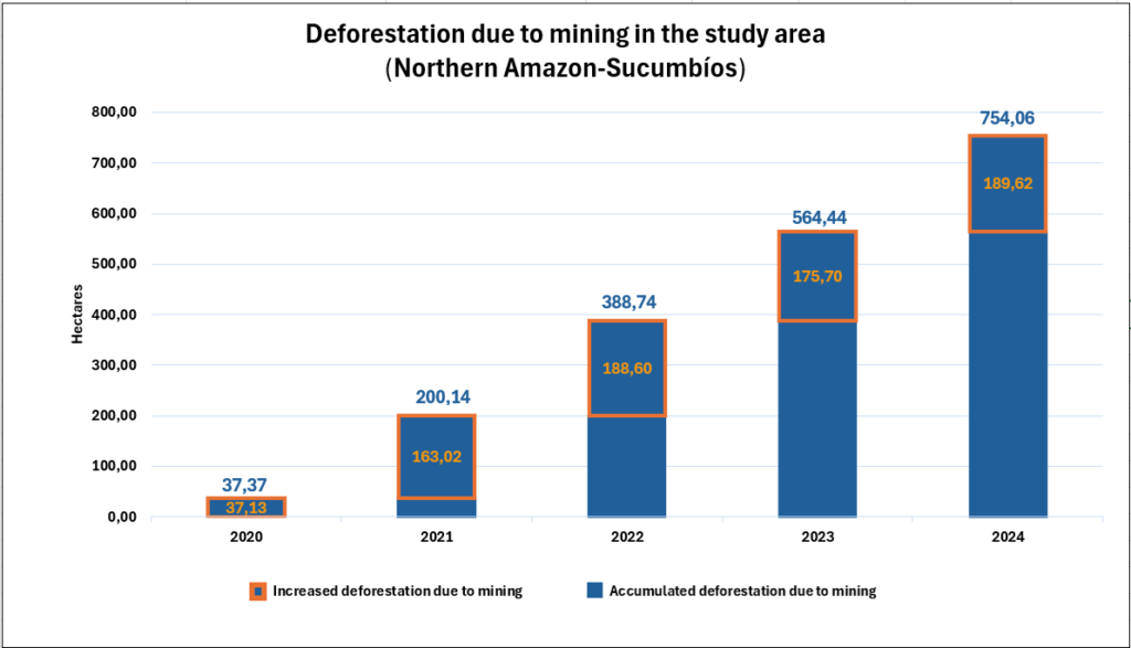
Graph 1. Mining activity 2017-2024 outside the Ecological Reserve Cofanes – Bermejo. Data: ACA/MAAP; Fundación EcoCiencia.
Mining Concessions
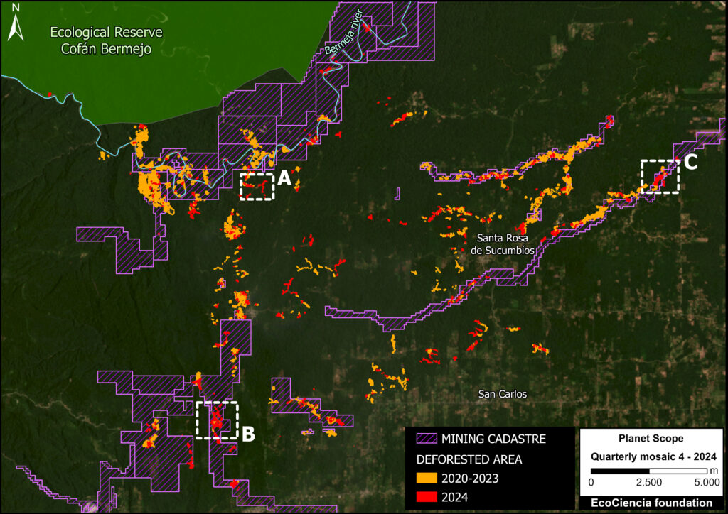
Figure 3. Overlay of mining activities with the mining cadastre. Data: ACA/MAAP; EcoCiencia; ARCOM; Planet
By adding the mining land designations, we determined that 59% of the mining deforestation (444 hectares) occured outside legal mining areas (Figure 3).
The Ecuadorian government, through the Ministry of Energy and Mines, grants mining rights for the exploitation of mineral resources in each of its phases (mining activity is divided into an exploration and development phase).
The exploration phase is further divided into three periods: initial exploration, advanced exploration, and economic evaluation.
Carrying out development activities prior to the granting of the right is illegal and may incur administrative or criminal sanctions.
Case Studies
We selected three case studies within the monitoring area to illustrate the rapid expansion of mining activity (see Insets A-C in Figure 3). The comparative panels below demonstrate the expansion of mining activity between May 2024 (left panel) and December 2024 (right panel) in each case.
Zoom A.
Panel A shows mining deforestation taking place outside designated mining concession areas. Moreover, this activity is occurring within a Shuar Indigenous territory (Taruka Territory).
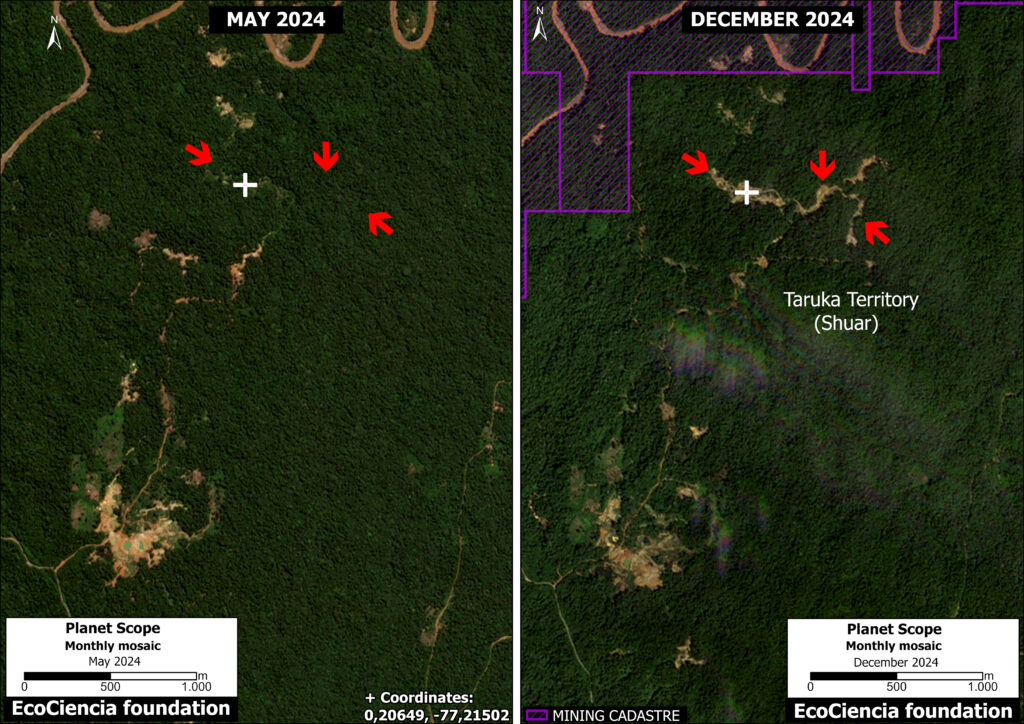
Panel Zoom A. Mining deforestation in Shuar Indigenous territory. Data: ARCOM (2025); Planet
Zoom B.
In Panel B, we identified 61.4 hectares of mining activity within the El Tuerto mining concession. However, this concession is currently in the initial exploration phase, meaning it has not yet been authorized for development.
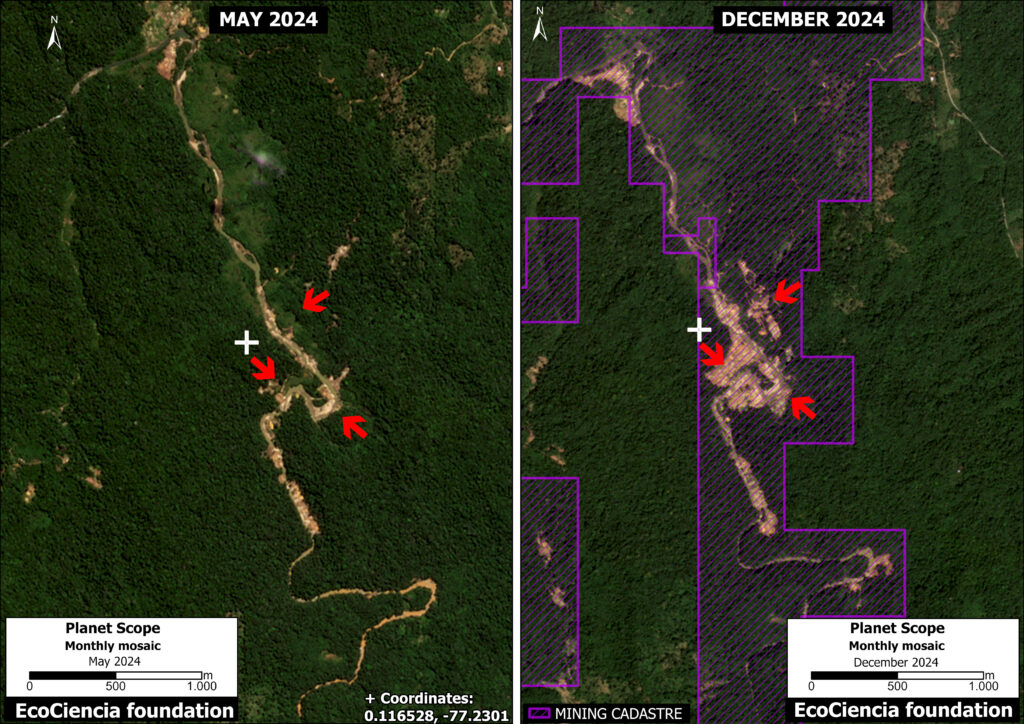
Panel Zoom B. Data: ARCOM (2025); Planet
Zoom C.
In Panel C, we recorded 19.65 hectares of mining activity within the El Porvenir mining concession. It is also currently in the exploration phase, with no authorization for development. Furthermore, this activity takes place within the ancestral territory of the Puma Kucha Commune (Kichwa Indigenous territory).
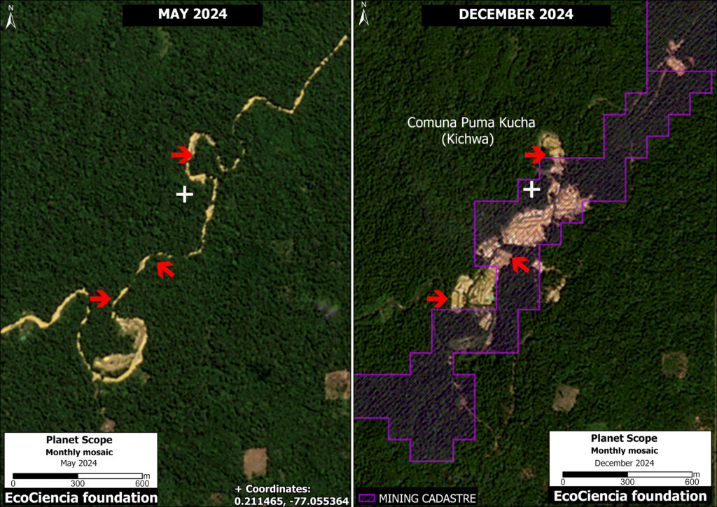
Panel Zoom C. Data: ARCOM (2025); Planet
Policy Implications
The recent gold mining deforestation described above highlights several key policy needs:
- Regulate public investment to ensure that the various conservation entities recognized by the national government have the necessary resources for oversight within their jurisdiction.
- Strengthen investigation and oversight processes in institutions responsible for ensuring environmentally responsible mining activities.
Methodology
In addition to Amazon Mining Watch to create the Base Map, we used LandTrendR, a temporal segmentation algorithm that identifies changes in pixel values over time, to detect forest loss at the edge of the Cofán-Bermejo Ecological Reserve between August 2017 and December 2024 using the Google Earth Engine platform. Importantly, this method was originally designed for moderate-resolution (30-meter) Landsat imagery (Reference 3), but was adapted for higher spatial resolution (4.7-meter) NICFI-Planet monthly mosaics (Reference 4).
References
- Antonio José Paz Cardona. (2023, 7 junio). Ecuador: minería ilegal sigue avanzando hacia el interior de la Reserva Ecológica Cofán Bermejo. Noticias Ambientales. https://es.mongabay.com/2023/06/mineria-ilegal-reserva-ecologica-cofan-bermejo-ecuador/
- Amazon Watch report ‘Oro, bandas y gobernanza: La crisis que enfrentan las comunidades indígenas amazónicas de Ecuador’
- Kennedy, R.E., Yang, Z., Gorelick, N., Braaten, J., Cavalcante, L., Cohen, W.B., Healey, S. (2018). Implementation of the LandTrendr Algorithm on Google Earth Engine. Remote Sensing. 10, 691.
- Erik Lindquist, FAO, 2021
Acknowledgments
This report is part of a series focused on the Ecuadorian Amazon through a strategic collaboration between the EcoCiencia Foundation and Amazon Conservation, with support from the Gordon and Betty Moore Foundation.

![]()
MAAP #226: AI to detect Amazon gold mining deforestation – 2024 update
Intro Image. Amazon Mining Watch interactive map.
As gold prices continue to increase, small-scale gold mining activity also continues to be one of the major deforestation drivers across the Amazon.
It often targets remote areas, thus impacting carbon-rich primary forests. Moreover, in many cases, we presume that this mining is illegal based on its location within conservation areas (such as protected areas and Indigenous territories) and outside mining concessions.
Given the vastness of the Amazon, however, it has been a challenge to accurately and regularly monitor mining deforestation across all nine countries of the biome, in order to better inform related policies in a timely manner.
In a previous report (MAAP #212) we presented the initial results of the new AI-based dashboard (known as Amazon Mining Watch) designed to address the issue of gold mining and related policy implications. Amazon Mining Watch (AMW) is a partnership between Earth Genome, the Pulitzer Center’s Rainforest Investigations Network, and Amazon Conservation.
This online tool (see Intro Image) analyzes satellite imagery archives to estimate annual mining deforestation footprints across the entire Amazon, from 2018 to 2024 (Note 1). Although the data is not designed for precise area measurements, it can be used to give timely estimates needed for management and conservation purposes.
For example, the cumulative data can be used to estimate and visualize the overall Amazon-wide mining deforestation footprint, and the annual data can be used to identify trends and emerging new mining areas. The algorithm is based on 10-meter resolution imagery from the European Space Agency’s Sentinel-2 satellite and produces 480-meter resolution pixelated mining deforestation alerts.
The only tool of this kind to be truly regional (Amazon-wide) in coverage, AMW can also help foster regional cooperation, in particular in transfrontier areas where a lack of interoperability between official monitoring systems might hamper interventions.
The Amazon Mining Watch partnership is currently working to enhance the functionality and conservation impact of the dashboard, AMW will be a one-stop shop platform including real-time visualization of: 1) AI-based detection of mining deforestation across all nine Amazonian countries, with quarterly updates; 2) Hotspots of urgent mining cases, including river-based mining; and 3) the socio-environmental costs of illegal gold mining with the Conservation Strategy Fund (CSF) Mining Impacts Calculator.
Here, we present an update focused on the newly added 2024 data and its context within the cumulative dataset (since 2018).
MAJOR FINDINGS
In the following sections, we highlight several major findings:
- Gold mining is actively causing deforestation in all nine countries of the Amazon. This impact is concentrated in three major areas: southeast Brazil, the Guyana Shield, and southern Peru. In addition, mining in Ecuador is escalating.
- The cumulative mining deforestation footprint in 2024 was over 2 million hectares (nearly 5 million acres) and has increased by over 50% in the past six years.
- Over half of all Amazon mining deforestation occurred in Brazil, followed by Guyana, Suriname, Venezuela, and Peru.
- While the cumulative footprint continues to grow, the rate of increase slowed in 2023 and 2024 after peaking in 2022, likely due to increased enforcement in Brazil.
- Over one-third of the mining deforestation has occurred within protected areas and Indigenous territories, where much of it is likely illegal. We highlight the most impacted areas.
- These results have important policy implications.
Base Map. Mining deforestation footprints, 2018-2024. Data: AMW, Amazon Conservation/MAAP.
Amazon & National Scale Patterns
The Base Map presents the gold mining footprint across the Amazon, as detected by the AMW algorithm. This data serves as our estimate of gold mining deforestation.
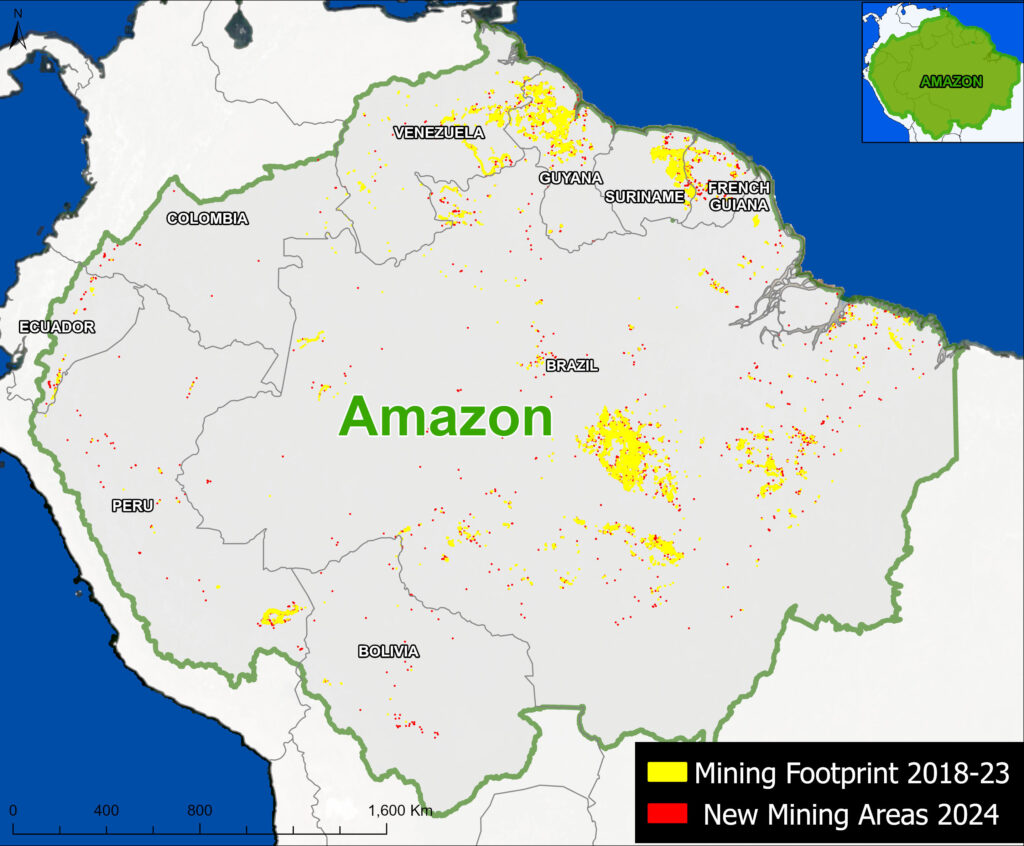
Yellow indicates the accumulated mining deforestation footprint for the years 2018- 2023; that is, all areas that the algorithm classified as a mining site vs other types of terrain, such as forest or agriculture. Red indicates the new mining areas detected in 2024.
Three major Amazon gold mining regions stand out: southeast Brazil (between the Tapajos, Xingu, and Tocantis Rivers), Guyana Shield (Venezuela, Guyana, Suriname, and French Guiana), and southern Peru (Madre de Dios). In addition, Ecuador has emerged as an important mining deforestation front.
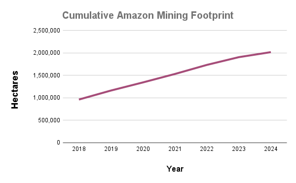
Graph 1. Amazon mining deforestation footprint. Data: AMW
Graph 1 quantifies the spatial data detected by the AMW algorithm.
The cumulative mining deforestation footprint in 2024 was 2.02 million hectares (4.99 million acres)
For context, the initial mining deforestation footprint was around 970,000 hectares in 2018, the first year of Amazon Mining Watch data.
Between 2019 and 2024, we estimate that the gold mining deforestation grew by 1.06 million hectares (2.61 million acres).
Thus, over half (52.3%) of the cumulative footprint has occurred in just the past six years.
Note that while the cumulative footprint continues to grow, the rate of increase slowed in 2023 and 2024 after peaking in 2022.
Graph 2 shows that, of the total accumulated mining (2.02 million hectares), over half has occurred in Brazil (55.3%), followed by Guyana (15.4%), Suriname (12.4%), Venezuela (7.3%), and Peru (7.0%).
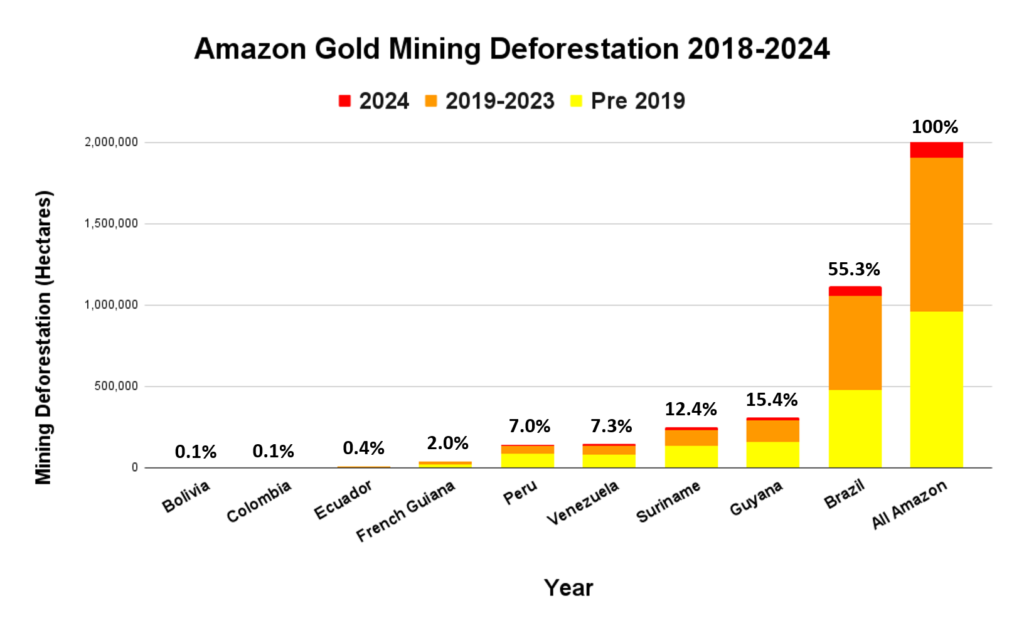
Graph 2. Gold mining deforestation across the Amazon, by country. Data: AMW, Amazon Conservation/MAAP
Graph 3 digs deeper into the AMW data, revealing additional trends between years. This data highlights the annual changes in detected mining deforestation. Note the trend across the entire Amazon at the top in green for overall context, followed by each country. Note that Brazil (orange line) accounts for much of the annual mining (over 50%).
In 2024, we documented the new gold mining deforestation of 111,603 hectares (275,777 acres). This total represents a decrease of 35% relative to the previous year 2023 and 45% relative to the peak year 2022.
The countries with the highest levels of new gold mining deforestation in 2024 were 1) Brazil (57,240 ha), 2) Guyana (19,372 ha), 3) Suriname (15,323 ha), 4) Venezuela (9,531 ha), and 5) Peru (6,020 ha). However, all five of these countries saw a major decrease in 2024, between 33% (Brazil and Suriname) and 46% (Peru).
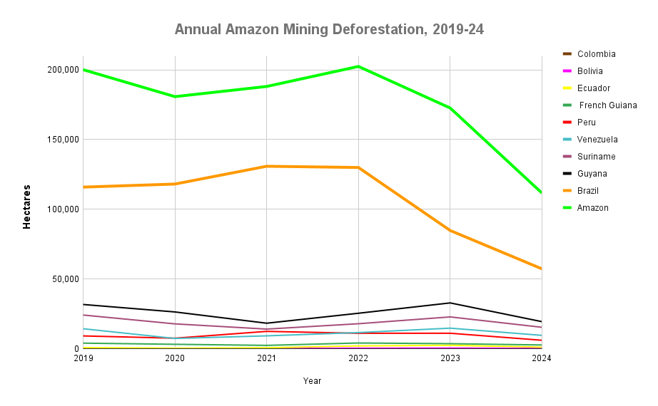
Graph 3. Annual changes in new mining deforestation. Data: AMW
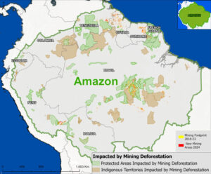
Figure 1. Protected areas & Indigenous territories impacted by mining deforestation. Data: AMW, ACA/MAAP.
Protected Areas & Indigenous Territories
We estimate that 36% of the accumulated mining deforestation in 2024 (over 725,000 hectares) occurred within protected areas and Indigenous territories (Figure 1; Note 2), where much of it is likely illegal.
Notably, the vast majority of this overall mining deforestation in protected areas and Indigenous territories has occurred in Brazil (88%).
Figure 2a. Top 10 impacted protected areas & Indigenous territories. Data: AMW, ACA/MAAP.
Figure 2a illustrates the top ten for both protected areas and Indigenous territories, in terms of both accumulated mining deforestation footprint and new mining deforestation in 2024. Figures 2b-d show zooms of the three main mining areas: southeast Brazil (2b), Guyana Shield (2c), and southern Peru (2d).
The top nine most impacted protected areas (in terms of accumulated footprint) are all in Brazil, led by Tapajós Environmental Protection Area. This area has lost over 377,000 hectares, followed by Amanã and Crepori National Forests, Rio Novo National Park, Urupadi, Jamanxim, and Itaituba National Forests, Jamanxim National Park, and Altamira National Forest. The top ten is rounded out by Yapacana National Park in Venezuela.
The three most impacted Indigenous territories are also in Brazil: Kayapó, Mundurucu, and Yanomami. Together, these three territories had a mining footprint of nearly 120,000 hectares. Fourth on the list is Ikabaru in Venezuela, followed by three in southern Peru (San Jose de Karene, Barranco Chico, and Kotsimba) with mining impact of over 17,000 hectares. Rounding out the top ten are Sai Cinza and Trincheira/Bacajá in Brazil, and San Jacinto in Peru.
We also estimate the expansion of over 38,000 hectares of new mining deforestation in protected areas and Indigenous territories in 2024. The protected area with the highest levels of new mining deforestation in 2024 was Tapajós Environmental Protection Area (nearly 19,000 hectares), followed by Amanã and Urupadi National Forests in Brazil, Rio Novo and Jamanxim National Parks in Brazil, Crepori National Forest in Brazil, Campos Amazonicos National Park in Brazil, Yapacan National Park in Venezuela, Guyane Regional Park in French Guiana, and Brownsberg Nature Reserve in Suriname.
Finally, the Indigenous territory with the highest levels of new mining deforestation in 2024 was Kayapó in Brazil (over 2,100 hectares), followed by Ikabaru in Venezuela, Yanomami, Aripuana, and Mundurucu in Brazil, Baramita in Guyana, Kuruáya in Brazil, Isseneru and Kamarang Keng, San Jose de Karene in Peu. It is worth noting that Kayapó, Mundurucu, and Yanomami territories in Brazil all experienced declines in the mining deforestation rate in 2024. For example, Yanomami went from its peak in 2021 to the lowest on record in 2024.
Most impacted areas in eastern Brazilian Amazon
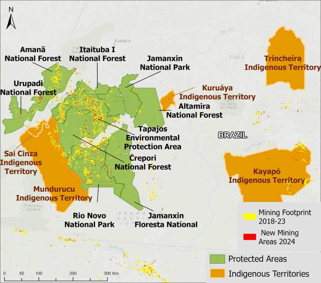
Figure 2b. Most impacted areas in eastern Brazilian Amazon. Data: AMW, Amazon Conservation/MAAP.
Most impacted areas in the Guyana Shield
Figure 2c. Most impacted areas in the Guyana Shield. Data: AMW, Amazon Conservation/MAAP.
Most impacted areas in the southern Peruvian Amazon
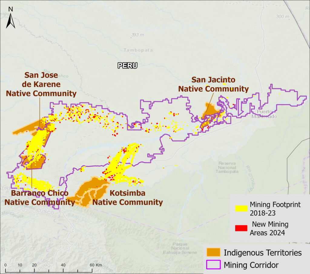
Figure 2d. Most impacted areas in the southern Peruvian Amazon. Data: AMW, Amazon Conservation/MAAP.
Conclusion & Policy Implications
Despite a recent downward trend in the rate of gold mining deforestation, the cumulative gold mining deforestation footprint continues to grow across the Amazon.
Our analysis shows that over one-third of this mining occurs within protected areas and Indigenous territories, the vast majority in Brazil. However, since the return of the Lula administration in 2023, Brazil has been ramping up enforcement efforts. This has contributed to the rapid decrease in area lost to mining across the Amazon, given Brazil’s outsized contribution to regional figures. This highlights again the importance of protected areas and Indigenous territories as a crucial policy instrument for the protection of the region’s ecosystems.
Although advances have been made in reducing illegal mining from protected areas in southern Peru, it continues to impact several Indigenous territories (MAAP #208, MAAP #196), particularly those surrounding the government-designated Mining Corridor. In fact, the most affected Indigenous territory in Peru, San Jose de Karene, has already lost over a third of its total area to illegal gold mining. These territories are part of a regional organization known as FENAMAD, which has been supporting legal actions to help the government make decisions for a rapid response to illicit activities (such as illegal mining) that affect indigenous territories. This process led to five government-led operations between 2022 and 2024, in three communities: Barranco Chico, Kotsimba and San José de Karene (MAAP #208).
In Ecuador, mining deforestation continues to threaten numerous sites, including protected areas and Indigenous territories, along the Andes-Amazon transition zone (MAAP #206, MAAP #221, MAAP #219). An upcoming series of reports will detail these threats.
AMW is an emerging and powerful new tool, but it does have some caveats. One is that any mining activity less than 500 square meters may not be accurately detected. For example, we have been monitoring small-scale mining in several protected areas, such as Madidi National Park in Bolivia and Puinawai National Park in Colombia, that are not yet detected by the algorithm. In these cases, direct real-time monitoring with satellites is still needed. These areas will soon be added to the AMW as mining “Hotspots” (MAAP#197).
This is also the case for river-based mining that does not cause a large footprint on the ground. Imagery with very high resolution has revealed active river barge mining in northern Peru (MAAP #189) and along the Colombia/Brazil border (MAAP#197). These areas will also soon be added to the AMW as mining “Hotspots.”
Gold mining in the Amazon is certain to stay a major issue in the coming years as gold prices continue to skyrocket, reaching over $3,000 an ounce in April 2025, driven by global economic uncertainty. While there are encouraging signs of effective enforcement in Brazil, governments here and across the region will have to compete with this rising financial incentive for mining activities.
Tools such as the Amazon Mining Watch, which will eventually publish quarterly updates of newly detected mining deforestation areas, can help governments, civil society, and local community defenders spot new fronts of gold mining and take action in near real-time. In a feature developed by Conservation Strategy Fund (CSF), it will also evaluate the economic costs of socio-environmental mining damages necessary for communities and managers to declare punitive damages.
The only dashboard of this kind to be fully regional in coverage, the AMW can also help foster regional cooperation, in particular in transfrontier areas where a lack of interoperability between official monitoring systems might hamper interventions that are aimed at combating a phenomenon that is linked to other nature crimes and is mostly controlled by international organized crime.
In the coming years, the MAAP and AMW teams will continue to publish both quarterly and annual reports of the dynamic mining situation in each country and across the Amazon, in addition to confidential reports directly to governments and community leaders on the most urgent cases.
Notes
1. Note that in this report, we focus on mining activity that causes deforestation. The vast majority is artisanal or small-scale gold mining, but other mining activities have also been detected, such as iron, aluminum, and nickel mines in Brazil and Colombia. Additional critical gold mining areas in rivers that are not yet causing deforestation (such as in northern Peru, southeast Colombia, and northwest Brazil; see MAAP #197), are not included in this report. This information is not yet displayed in Amazon Mining Watch, but future updates will include river-based mining hotspots.
2. Our data source for protected areas and Indigenous territories is from RAISG (Amazon Network of Georeferenced Socio-Environmental Information), a consortium of civil society organizations in the Amazon countries. This source (accessed in December 2024) contains spatial data for 5,943 protected areas and Indigenous territories, covering 414.9 million hectares across the Amazon.
Acknowledgments
We thank colleagues from partner organizations around the Amazon for helpful comments on the report, including: Earth Genome, Conservación Amazónica (ACCA & ACEAA) & Federación Nativa del Río Madre de Dios y Afluentes (FENAMAD), Fundación EcoCiencia, Fundación para la Conservación y el Desarrollo Sostenible (FCDS), and Instituto Centro de Vida (ICV) & Instituto Socioambiental (ISA).
This report was made possible by the generous support of the Gordon and Betty Moore Foundation.
![]()
MAAP #225: Carbon in the Amazon (part 4): Protected Areas & Indigenous Territories
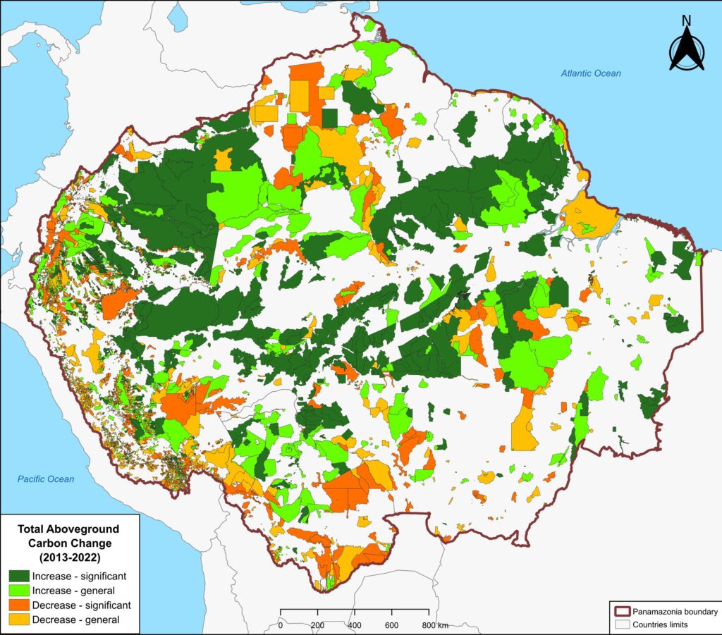
Figure 1. Total aboveground carbon change, Amazon protected areas & Indigenous territories 2013-2022. Data: Planet, ACA/MAAP.
We continue our ongoing series about carbon in the Amazon.
In part 1 (MAAP #215), we introduced a new dataset (Planet’s Forest Carbon Diligence) with wall-to-wall estimates for aboveground carbon at an unprecedented 30-meter resolution between 2013 and 2022. In part 2 (MAAP #217), we highlighted which parts of the Amazon are currently home to the highest (peak) carbon stocks. In part 3 (MAAP #220), we showed key cases of carbon loss (deforestation) and gain across the Amazon.
A key finding from this series is that the Amazon biome is teetering between a carbon source and sink. That is, historically the Amazon has functioned as a critical sink, with its forests accumulating carbon if left undisturbed. However, relative to the 2013 baseline, the Amazon flipped to a source during the high deforestation, drought, and fire seasons of 2015-2017. It then rebounded as a narrow carbon sink in 2022.
Here, in part 4, we focus on the importance of aboveground carbon in protected areas and Indigenous territories, which together cover 49.5% (414.9 million hectares) of the Amazon biome (see Figure 1).
We find that, as of 2022, Amazonian protected areas and Indigenous territories contained 34.1 billion metric tons of aboveground carbon (60% of the Amazon’s total). Importantly, in the ten years between 2013 and 2022, they functioned as a significant carbon sink, gaining 257 million metric tons.
With this data, we can also analyze aboveground carbon for each protected area and Indigenous territory. For example, Figure 1 illustrates aboveground carbon loss vs. gain for each protected area and Indigenous territory during the 10-year period of 2013 – 2022 (see details below).
Below, we further explain and illustrate the key findings.
Amazon-wide & Country-level Results
Amazonian protected areas and Indigenous territories currently cover nearly half (49.5%) of the Amazon biome, but contain 60% of the aboveground carbon. Together they contained 34.1 billion metric tons of aboveground carbon as of 2022, gaining 257 million metric tons since 2013, thus functioning as a carbon sink (Figure 2).1,2
In contrast, areas outside of protected areas and Indigenous territories (424 million hectares) contained 22.6 billion metric tons of aboveground carbon as of 2022, losing 255 million metric tons since 2013, thus functioning as an overall carbon source.
Thus, the carbon sink function of protected areas and Indigenous territories narrowly offsets the emissions in the rest of the Amazon.
We emphasize that the protected areas and Indigenous territories functioned as a significant carbon sink (p-value = 0.01), while the outside areas were not a significant source (p-value= 0.15).
Regarding results by country, protected areas and Indigenous territories were significant carbon sinks in Colombia, Brazil, Suriname, and French Guiana (Guyana gained carbon but not significantly). In contrast, they were significant carbon sources in Bolivia and Venezuela (Peru and Ecuador lost carbon but not significantly).
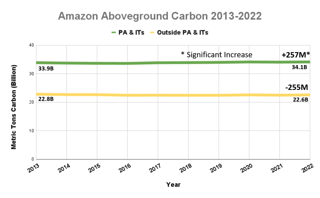
Figure 2. Amazon aboveground carbon 2013-2022, within vs. outside protected areas and Indigenous territories. Data: Planet, ACA/MAAP.
Individual Protected Area & Indigenous Territory Results
Figure 1 (see above) illustrates total aboveground carbon loss vs. gain for each protected area and Indigenous territory during the 10-year period of 2013 – 2022.
Overall, we found 1,103 areas that served as significant carbon sinks (dark green) during this period (238 protected areas and 865 Indigenous territories). These areas are concentrated in the northern and central Amazon. See Annex 1 for a list of specific areas that were significant carbon sinks.
It is important to note that deforestation pressures currently threaten several of these significant carbon sinks, including Chiribiquete National Park and Nukak-Maku Indigenous Reserve in Colombia, Sierra del Divisor National Park in Peru, and Canaima National Park in Venezuela.
In contrast, we found 1,439 areas (156 protected areas and 1,283 Indigenous territories) that served as significant carbon sources. It is important to note that some areas with little documented deforestation, such as Alto Purus National Park, may have carbon loss from natural causes.
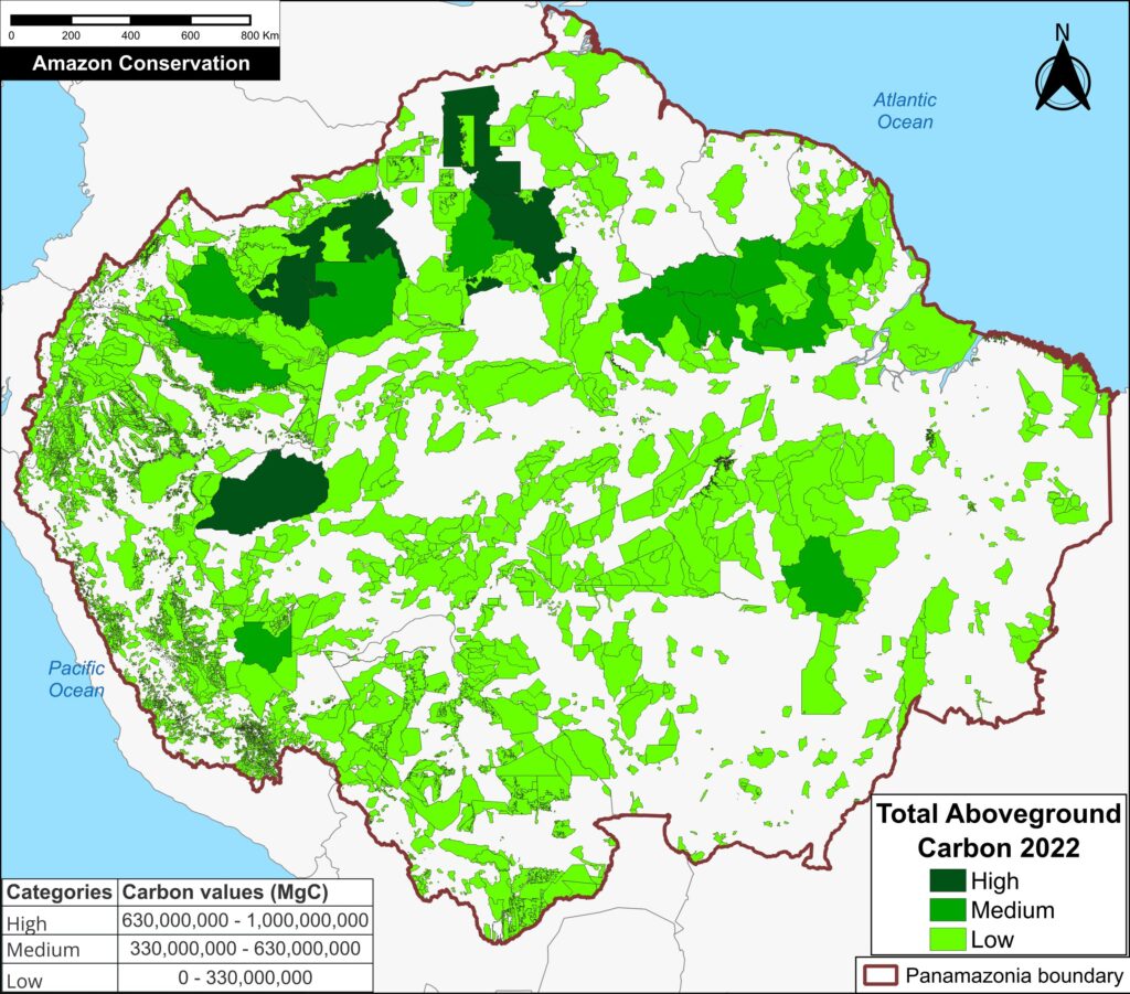
Figure 3. Total aboveground carbon stocks in each protected area and Indigenous territory. Data: Planet, ACA/MAAP.
Figure 3 offers the most recent snapshot of total aboveground carbon stocks in each protected area and Indigenous territory.
It presents data for 2022 categorized into three groups of High, Medium, and Low. Note that the highest carbon totals (over 330 million metric tons) are concentrated across the large designated areas of the northern Amazon.
These High and Medium carbon areas may be considered to have the highest overall conservation value purely in terms of total carbon.
See Annex 1 for specific areas with the highest carbon stocks as of 2022.
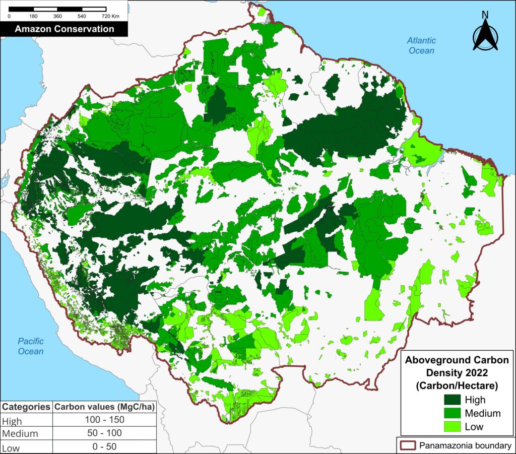
Figure 4. Aboveground carbon density in each protected area and Indigenous territory (2022). Data: Planet, ACA/MAAP
Finally, Figure 4 also displays the most recent data (2022) in each protected area and Indigenous territory, but standardized for area (aboveground carbon/hectare).
Note that the highest carbon totals (over 50 metric tons per hectare) are more evenly concentrated across the Amazon.
These High and Medium carbon areas may be considered to have the highest carbon conservation value per hectare.
Policy Implications:
Unlocking the Climate Value of Protected Areas and Indigenous Territories in the Amazon
Policy and finance for tropical forests as a climate solution have largely focused on reducing emissions from deforestation and forest degradation (REDD+). These efforts have made important strides in slowing and directing finance to tackle forest loss, particularly in high-deforestation regions. However, this emphasis on avoided emissions overlooks a critical component of the global carbon cycle: the carbon sink function (gaining of carbon over time) of primary tropical forests — which this analysis using Planet’s Forest Carbon Diligence data show is both measurable and significant.
This omission leaves a major flux in the carbon system—ongoing carbon sequestration in old-growth forests—outside the scope of existing market or non-market incentives. Critically, many of these carbon-absorbing forests are already located within established protected areas and indigenous territories. These areas are globally recognized for their importance in biodiversity conservation and for the stewardship provided by Indigenous Peoples and local communities.
As global attention increasingly turns to engineered carbon removal strategies such as BECCS (Bioenergy with carbon capture and storage) and Direct Air Capture, there is an urgent need to recognize that Amazonian forests are already performing this function—naturally and at scale. Yet the value of Protected Areas and Indigenous territories as a potent carbon sink is neither monetized nor rewarded under current frameworks, unless they can demonstrate that they are under threat from deforestation or degradation in order to access REDD+ finance. An emerging exception is the High Integrity Forests Investment Initiative (HIFOR), which recognizes the value of carbon sequestration in old-growth forests, but does not generate tradable credits for each ton absorbed.5 The Tropical Forests Forever Fund (TFFF) proposed by Brazil for adoption at COP 30, would also reward forest countries at a rate of approximately US$ 4.00/year for every hectare of tropical forest they protect, regardless of whether they are under threat.6
To date, however, protected areas and Indigenous territories, despite their proven climate contribution, often lack the financial support necessary to ensure long-term effectiveness and resilience. As a result, they often face chronic underfunding,7 limiting their long-term effectiveness and resilience. Policy innovation is needed to close this gap and integrate the carbon sink function of mature forests into funding mechanisms for forest protection. Doing so would unlock meaningful incentives for the continued, long-term stewardship of these high-carbon ecosystems and would ensure that one of the planet’s most effective natural climate solutions receives the attention and resources it deserves.
Annex 1
Specific areas that were significant carbon sinks include:
Otishi, Sierra del Divisor, Güeppí-Sekime and Yaguas National Parks, Matsés, and Pucacuro National Reserves, Ashaninka Communal Reserve, and Cordillera Escalera and Alto Nanay- Pintuyacu Chambira Regional Conservation Area, Matses, Pampa Hermosa, and Yavarí – Tapiche Indigenous Reserves, and Kugapakori, Nahua, Nanti Territorial Reserve in Peru;
Amacayacu, Chiribiquete, Cahuinari, Rio Pure, and Yaigoje Apaporis National Parks, Nukak Natural Reserve, Amazonas Forest Reserve, and Putumayo and Nukak-Maku, Yaigoje Rio Apaporis and Vaupes Indigenous Reserve in Colombia;
Campos Amazônicos, Juruena, Mapinguari, Nascentes do Lago Jari, Serra do Divisor, and Montanhas do Tumucumaque National Parks, Amanã, Aripuanã, Crepori, Tapajós, and Tefé National Forests in Brazil, Itaituba and Jatuarana National Forests, and Alto Rio Negro, Baú, Aripuanã, Aripuanã, Apyterewa, Mundurucu, and Vale do Javari Indigenous Territories in Brazil.
Achuar Indigenous Territory and Zona Intangible Tagaeri – Taromenane in Ecuador; Manuripi Heath National Reserve and Takana, Takana II, and Yuracare Indigenous Reserves in Bolivia; Central Suriname and Sipaliwini Nature Reserves in Suriname; Canaima National Park in Venezuela; and Parc Amazonien de Guyane National Park in French Guiana,
Specific areas with the highest carbon stocks, as of 2022, include:
Alto Purús, Manu, Sierra del Divisor, and Cordillera National Parks in Peru; Chiribiquete National Park in Colombia; Montanhas do Tumucumaque, Pico da Neblina, Jaú, and Juruena National Parks and Yanomami, Menkragnoti, Kayapó, Mundurucu, and Vale do Javari Indigenous Territories in Brazil; Caura and Canaima National Parks in Venezuela; and Parc Amazonien de Guyane National Park in French Guiana;
Methodology
We analyzed Planet Forest Carbon Diligence, a cutting-edge new dataset from the satellite-based company Planet, featuring a 10-year historical time series (2013 – 2022) with wall-to-wall estimates for aboveground carbon density at 30-meter resolution.3,4
One notable caveat of this data is that it does not distinguish aboveground carbon loss from natural vs human-caused drivers, so additional information may be incorporated to understand the context of each area.
Based on these data, annual aboveground carbon values were estimated in Amazonian protected areas and Indigenous territories to obtain a time series for 2013-2022. In addition, the Mann-Kendall test was used to analyze trends in the generated time series.
Our data source for protected areas and Indigenous territories is from RAISG (Amazon Network of Georeferenced Socio-Environmental Information), a consortium of civil society organizations in the Amazon countries. This source (accessed in December 2024) contains spatial data for 5,943 protected areas and Indigenous territories, covering 414.9 million hectares across the Amazon.
We determined that many of these areas (4,000) did not include creation date metadata, prohibiting any time-series control for that variable. Instead, we used the most current extent of protected areas and Indigenous territories as a proxy for those that existed from 2013 to 2022.
There was substantial overlap between protected areas and Indigenous territories, but we accounted for this to avoid double counting of the overlapping areas.
The aboveground carbon values for protected areas and Indigenous territories were calculated for each country and then summed across the Amazon.
The remaining areas were combined into the category of “Outside protected areas and Indigenous territories” and also calculated for each country and summed across the Amazon.
Our geographic range for the Amazon is a hybrid designed for maximum inclusion: biogeographic boundary (as defined by RAISG) for all countries, except for Bolivia and Peru, where we use the watershed boundary, and Brazil, where we use the Legal Amazon boundary. Our area estimate for this definition of the Amazon biome is 839.2 million hectares.
Notes
1 Breaking down the results by category, protected areas contained nearly 21.1 billion metric tons of aboveground carbon as of 2022, gaining over 204 million metric tons since 2013, while Indigenous territories contained over 16.8 billion metric tons of aboveground carbon as of 2022, gaining over 132 million metric tons since 2013. Note that protected areas and Indigenous territories overlap in many areas.
2 Standardizing for area (that is, calculating the results per hectare), protected areas and Indigenous territories contained 82.2 metric tons of aboveground carbon per hectare as of 2022, gaining a net 0.6 metric tons per hectare since 2013. In contrast, areas outside of protected areas and Indigenous territories contained 53.2 metric tons of aboveground carbon per hectare as of 2022, losing a net 0.6 metric tons per hectare since 2013.
3 Anderson C (2024) Forest Carbon Diligence: Breaking Down the Validation and Intercomparison Report. https://www.planet.com/pulse/forest-carbon-diligence-breaking-down-the-validation-and-intercomparison-report/
4 In terms of the limitations of Planet’s Forest Carbon Diligence data, Duncanson et al (2025) recently wrote a Letter in Science focused on spatial resolution for forest carbon maps. Given the natural constraint of the size of a tree, they discuss the challenge of pixel-level validation below 5 meters for forest carbon monitoring. The authors state that spatial resolution should at minimum exceed the crown diameter of a typical large tree, which is about 20 meters for tropical forests. In this sense, the 30-meter product exceeds this limitation.
Duncanson et al (2025) Spatial resolution for forest carbon maps. Science 387: 370-71.
5 WCS High Integrity Forest Investment Initiative (HIFOR): The Science Basis
6 https://www.bloomberg.com/news/newsletters/2025-04-04/too-big-to-fell-brazil-takes-trees-to-wall-street?cmpid=BBD040425_GR
7 UNEP-WCMC, IUCN, and NGS. (2022). Protected Planet Report 2022. Cambridge, UK: UNEP-WCMC.
Acknowledgments
Through a generous sharing agreement with the satellite company Planet, we have been granted access to this data across the entire Amazon biome for the analysis presented in this series.
We thank colleagues from the following organizations for helpful comments on this report: Planet, Conservación Amazónica – ACCA, Conservación Amazónica -ACEAA, Gaia Amazonas, Ecociencia, and Instituto del Bien Común.
We especially thank colleagues at Conservación Amazónica – ACCA for help with the 10-year data analysis.
This report was made possible by the generous support of the Norwegian Agency for Development Cooperation (NORAD)
![]()
Citation
Bodin B, Finer M, Castillo H, Mamani N (2025) Carbon in the Amazon (part 4): Protected Areas & Indigenous Territories. MAAP: 225.
MAAP #224: Illegal Deforestation in the Colombian Amazon – Chiribiquete National Park & Llanos del Yarí – Yaguará II Indigenous Reserve
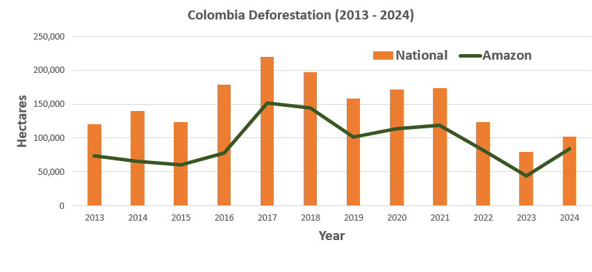
Graph 1. Deforestation in the Colombian Amazon, 2013-2024. Data: IDEAM, UMD/GFW
The Colombian Environment Ministry recently announced that, after the country experienced its lowest deforestation in over 20 years in 2023, forest clearing rose 35% in 2024 (Graph 1). In addition, the Ministry reported an increase in medium-sized clearing, indicating relatively organized and funded operations (Note 1).
Over the past 10 years, 60% of the national deforestation has occurred in the Colombian Amazon. As Graph 1 indicates, there was a large increase in 2017 following the peace accords with the guerrilla group FARC, and a subsequent decrease in 2022 and 2023 (Note 2). Initial estimates indicate an increase for 2024 (Note 3). Overall, there have been nearly 1,200,000 hectares of deforestation across the Colombian Amazon over the past 10 years.
Much of the clearing in the Colombian Amazon is likely illegal (Law of 2021), occurring in national protected areas and Indigenous reserves.
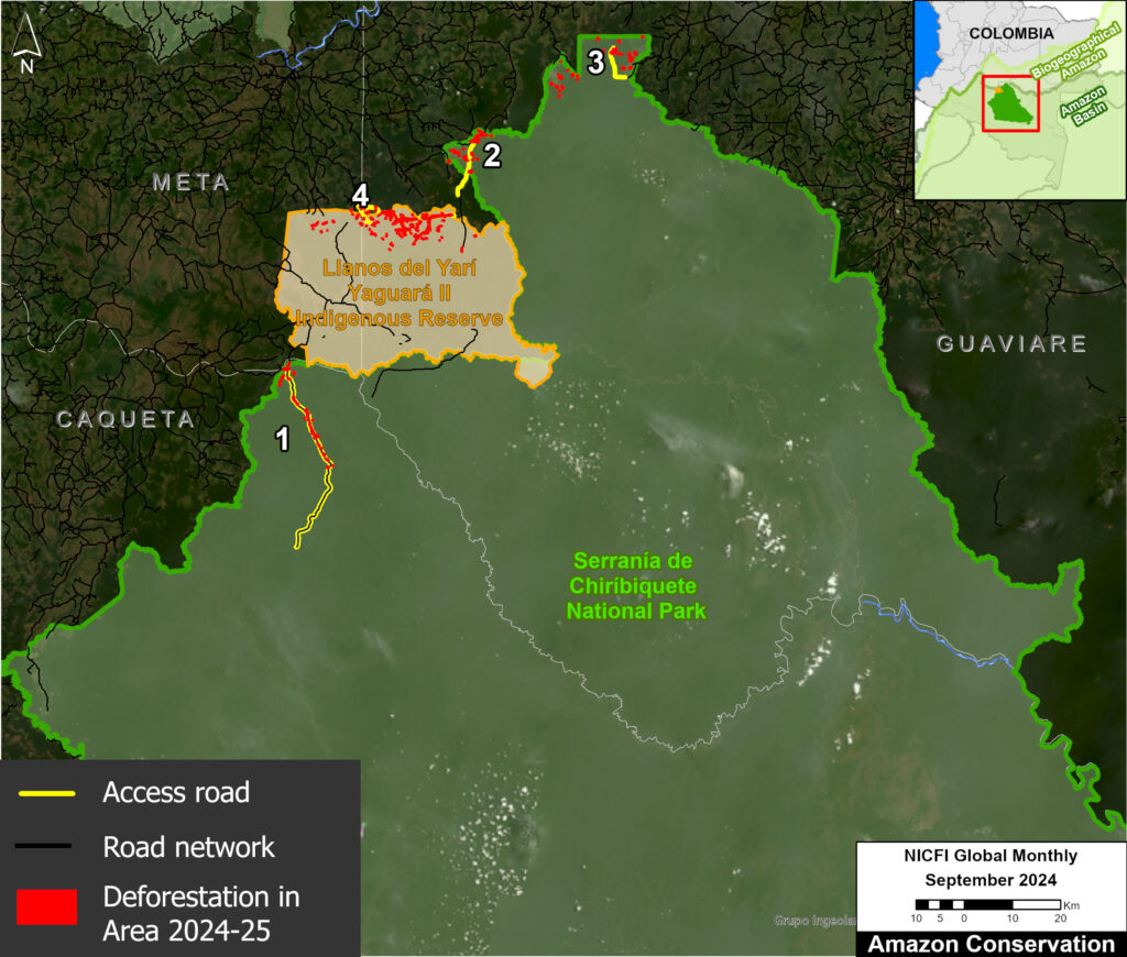
Base Map: Focal area of the report. Data: ACA/MAAP, FCDS.
Here, we highlight recent 2024-25 deforestation in two key areas in the core of the Colombian Amazon: Chiribiquete National Park (Parque Nacional Natural Serranía de Chiribiquete) and the adjacent Llanos del Yarí – Yaguará II Indigenous Reserve (Resguardo Indígena Llanos del Yarí – Yaguará II). See the Base Map for additional context.
These areas are affected by several deforestation pressures, such as the expansion of road infrastructure, extensive livestock farming, pasture expansion, land grabbing, and illicit crops (coca). These pressures often interact, with access roads facilitating livestock farming and pasture expansion, which then facilitates land grabbing.
These drivers have led to the deforestation of over 7,100 hectares in Chiribiquete National Park since its most recent expansion in 2018 (see Annex 1).
Most recently, we estimate the deforestation of 525 hectares in Chiribiquete National Park (concentrated in the northern sector) during 2024-25, plus an additional 856 hectares in Llanos del Yarí – Yaguará II Indigenous Reserve. Note that most of the deforestation follows access roads.
Below, we illustrate the key cases of recent deforestation in both areas, highlighting the role of access roads as facilitators of illegal clearing. These case studies feature satellite images and overflight photos.
Any deforestation in these areas is noteworthy not only due to its impacts on primary forests, biodiversity, and Indigenous groups, but also on carbon reserves. In an upcoming report, we reveal that Chiribiquete National Park is one of the Amazon’s most important and significant carbon sinks.
This report was conducted in collaboration with our Colombian partner Foundation for Conservation and Sustainable Development (Fundación para la Conservación y el Desarrollo Sostenible – FCDS), and with financial support from the Overbrook Foundation.
Illegal Deforestation Cases
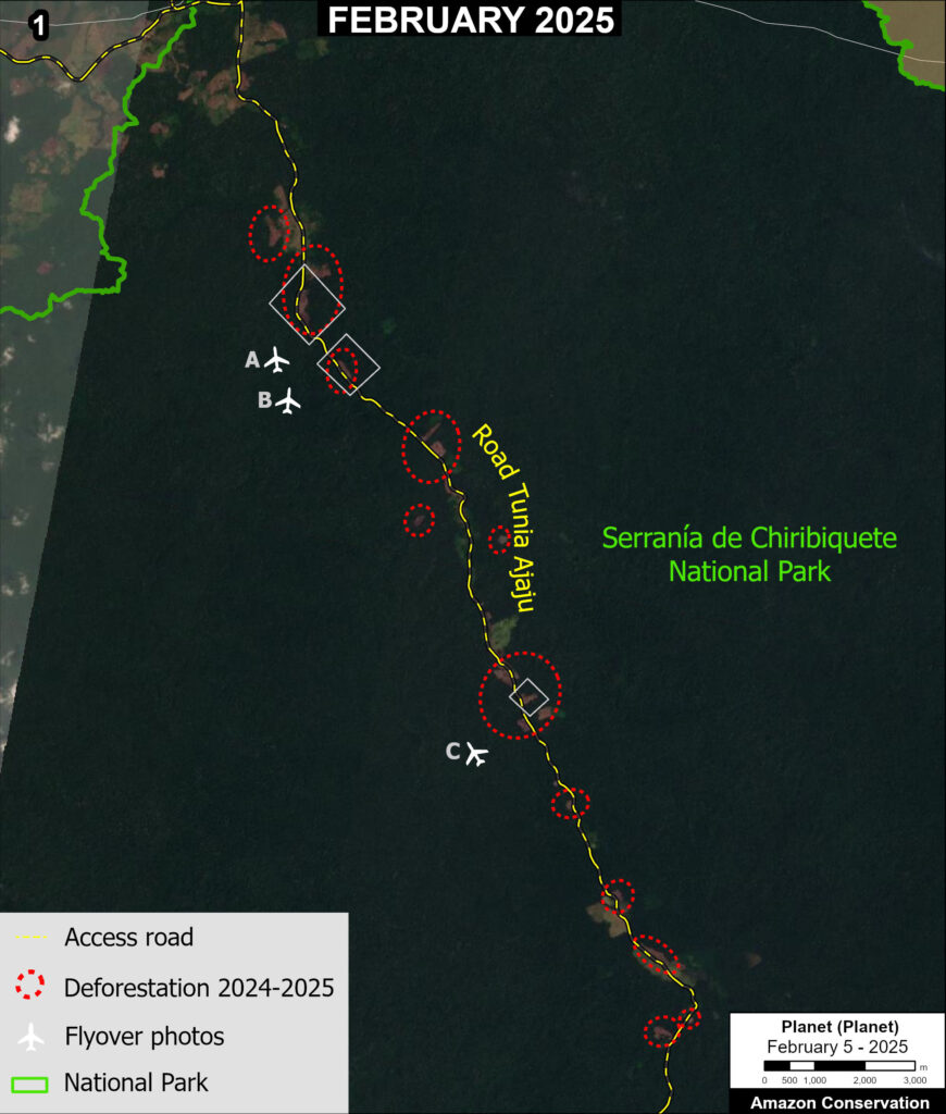
Zoom 1. Chiribiquete National Park. Data: ACA/MAAP, FCDS.
Chiribiquete National Park: Sector el Camuya
Zoom 1 shows the deforestation of 198 hectares during 2024 and early 2025 (indicated by red circles), along the Tunia-Ajaju road in the northwest sector of Chiribiquete National Park.
This road extends 45.3 kilometers into the park.
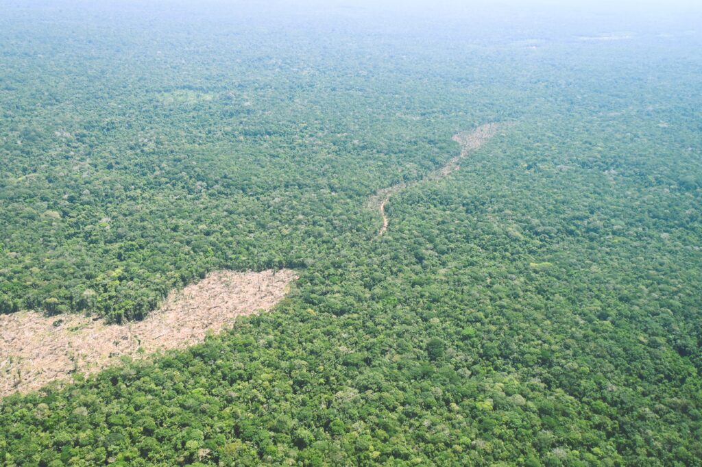
Photo 1A. Data: FCDS.
In January 2025, FCDS conducted a low-altitude overflight over this sector (see Photos 1A-C).
These photos bring an added level of spatial resolution and perspective, providing greater insight into the cause of the recent deforestation.
Photo 1A highlights deforestation associated with the opening of access roads in the park.
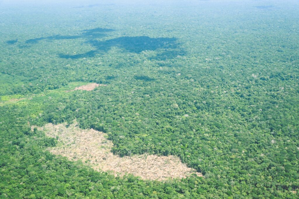
Photo 1B. Data: FCDS.
Photos 1B-C illustrate more clearly the fresh deforestation for expansion of the agricultural frontier.
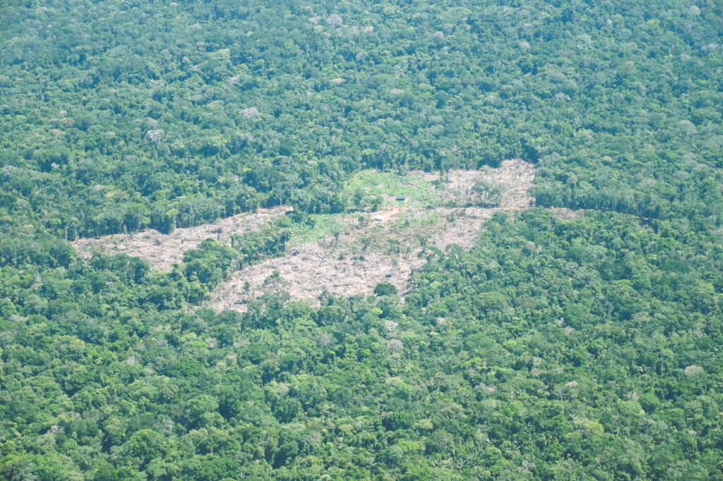
Photo 1C. Data: FCDS.
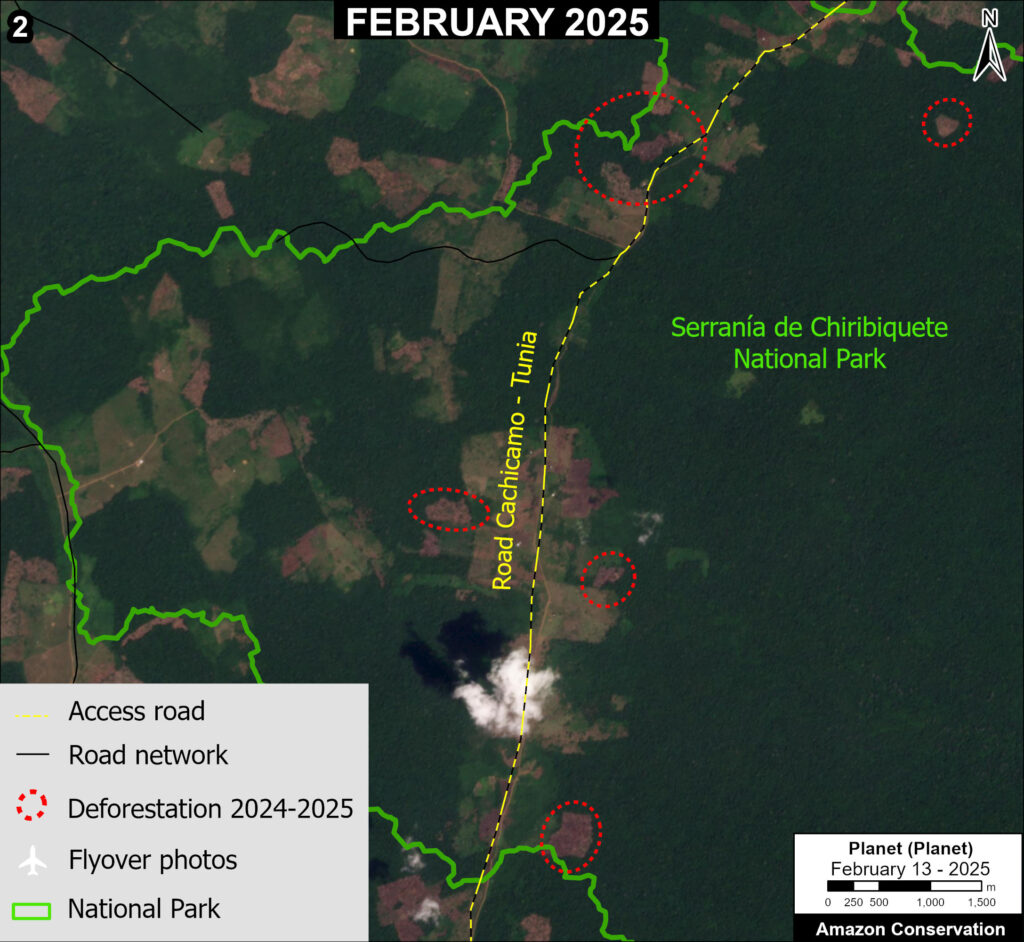
Zoom 2. Chiribiquete National Park. Data: ACA/MAAP, FCDS.
Chiribiquete National Park: Sector El Palmar
Zoom 2 shows the deforestation of 179 hectares during 2024 and early 2025 (indicated by red circles), along the Cachicamo-Tunia road in the northern sector of Chiribiquete National Park.
This road extends 21 kilometers inside the park.
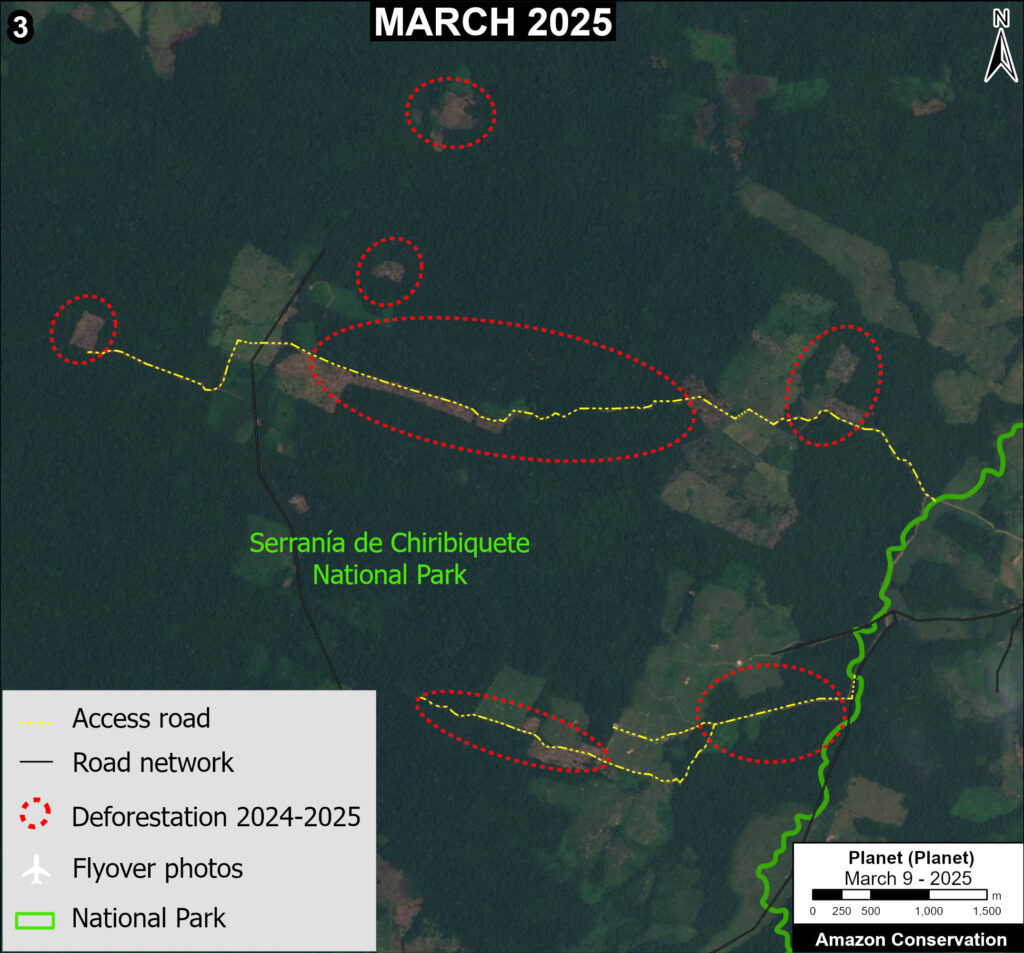
Zoom 3. Chiribiquete National Park. Data: ACA/MAAP, FCDS.
Chiribiquete National Park: Sector Norte
Zoom 3 shows the deforestation of 148 hectares during 2024 and early 2025 (indicated by red circles) along or near new access roads in the northeast sector of Chiribiquete National Park.
We estimate the construction of 15.2 kilometers inside the park during this period (also indicated by red circles).
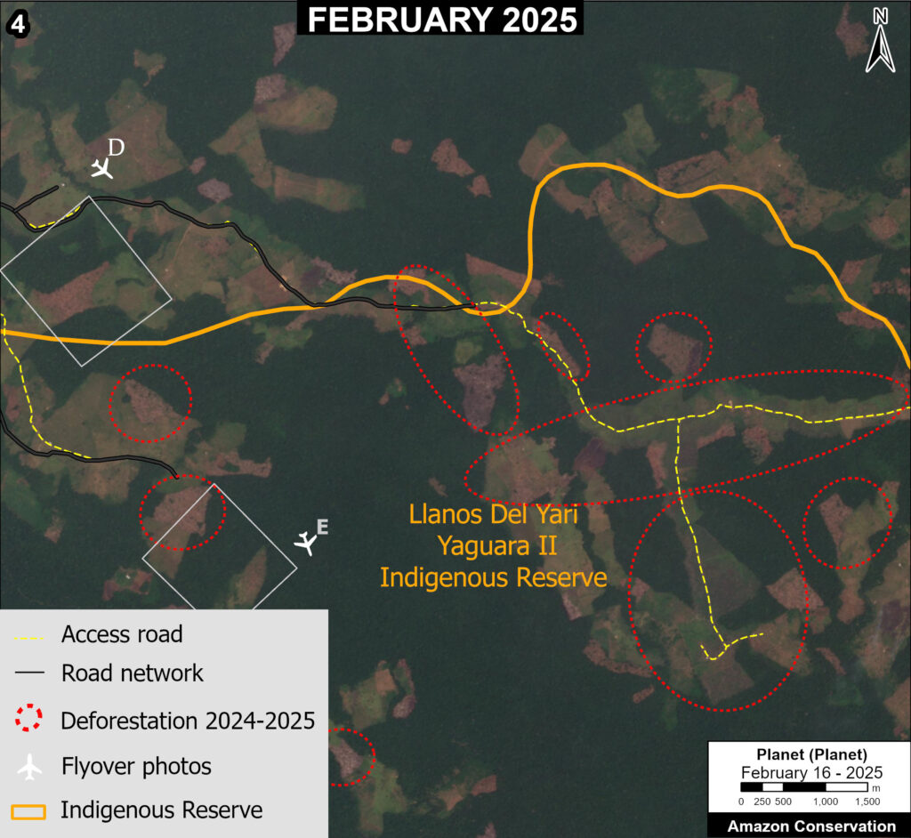
Zoom 4. Yarí – Yaguará II Indigenous Reserve. Data: ACA/MAAP, FCDS.
Yarí – Yaguará II Indigenous Reserve
Zoom 4 shows the major deforestation of 1,070 hectares during 2024 and early 2025 along or near a new illegal road in the northern part of Yarí – Yaguará II Indigenous Reserve.
This road extends 22 kilometers inside the reserve.
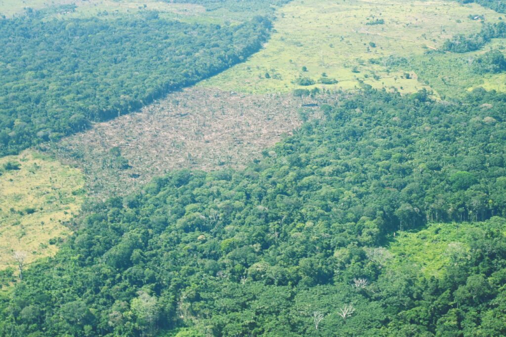
Photo 4D. Data: FCDS.
In January 2025, FCDS conducted a low-altitude overflight over this area, confirming and documenting the new patches of deforestation (see Photos 4D-E).
As noted above, these photos bring an added level of spatial resolution and perspective, providing greater insight into the cause of the recent deforestation.
Both Photos 4D-E indicate the expansion of livestock agricultural activities.
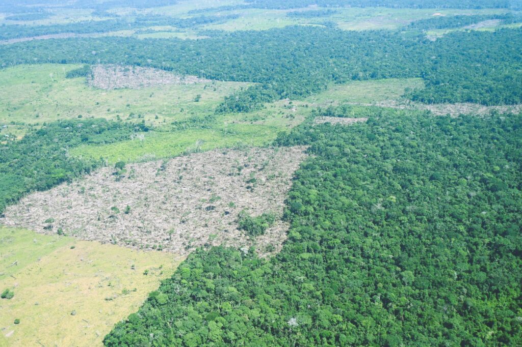
Photo 4E. Data: FCDS.
Policy Implications
The recent deforestation in protected areas and Indigenous territories described above highlights the shortcomings of several current policies of the State of Colombia, which have failed to stem the expansion of cattle ranching and illicit crops as a first step towards land grabbing and permanent deforestation. Several steps could be taken to overcome that failure:
- Improved coordination between public entities concerned with law enforcement against drivers of deforestation, shortening investigation processes and leading to more effective and comprehensive responses.
- The inclusion of targets for the reduction of deforestation and the mitigation of impacts on natural forests in agreements for the cessation of hostilities and the de-escalation of the conflict between the national government and armed groups.
- Monitoring and regulation of public investments for the expansion of livestock farming by local and national governments, to reduce public incentives for deforestation.
Annex 1.
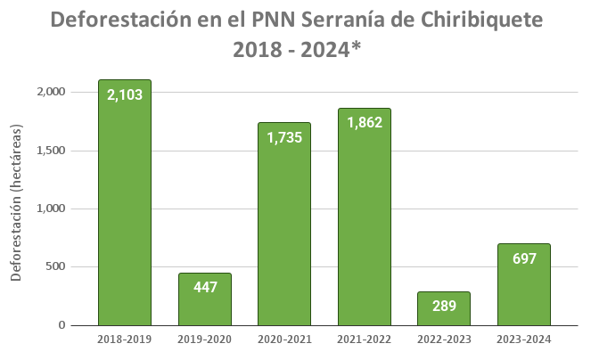
Annex 1. Data: FCDS
Notes
1 Griffin, O (2025) Colombia deforestation rose 35% in 2024, minister says
2 Based on data from Colombia’s Institute of Hydrology, Meteorology and Environmental Studies (Instituto de Hidrología, Meteorología y Estudios Ambientales – IDEAM), a government agency of the Ministry of Environment and Sustainable Development.
3 Based on data from the University of Maryland/Global Forest Watch.
Acknowledgments
This report was conducted in collaboration with our Colombian partner Foundation for Conservation and Sustainable Development (Fundación para la Conservación y el Desarrollo Sostenible – FCDS), and with financial support from the Overbrook Foundation.
MAAP #219: Illegal mining expansion in the Ecuadorian Amazon (Punino area)
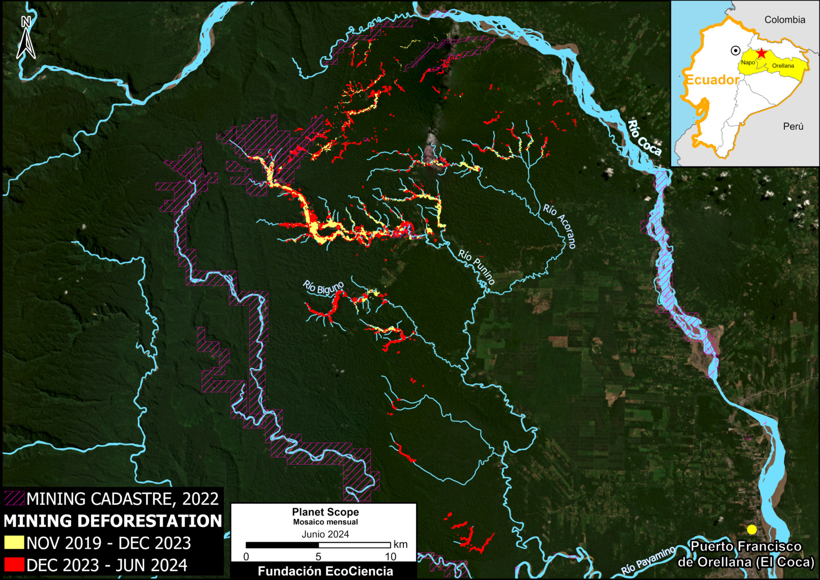
Base Map. Mining deforestation in the heart of the Ecuadorian Amazon (Punino area). Data: ARCERNNR 2022, Planet-NICFI, EcoCiencia.
In a series of previous reports, we warned about the emergence and expansion of illegal mining deforestation in the heart of the Ecuadorian Amazon, in the area surrounding the Punino River, located between the provinces of Napo and Orellana (MAAP #182, MAAP #151).
In the most recent report, we informed that this mining impact had reached 1,000 hectares (MAAP #206).
Here, we provide an update on the growing mining activity in and around the Punino River basin during the first half of 2024.
The Base Map shows an increase of 420 hectares in 2024 (indicated in red), bringing the total impact to 1,422 hectares (3,500 acres) since its inception in 2019 (yellow and red combined). This total is equivalent to more than 2,000 professional soccer fields.
The Base Map also shows that the vast majority (90%) of the mining deforestation is located outside the limits of the areas authorized for such activity (according to the mining registry updated to 2022). In other words, the vast majority of mining is likely illegal.
We emphasize that the mining deforestation has rapidly expanded to enter the limits of two protected areas: Sumaco-Napo Galeras National Park and El Chaco Municipal Conservation Area (see Figure 1, below).
In addition, the mining deforestation is actively expanding within the boundaries of Indigenous territories of the Kichwa nationality (see Figure 2, below).
Below we illustrate in more detail the rapid increase in mining deforestation, especially in these protected areas and Indigenous territories.
Mining expansion in the Punino area, 2019-2024
Chart 1 illustrates the steadily increasing mining deforestation in the Punino area over the past 5 years. The impact began in 2019, reaching 1,000 hectares by the end of 2023, and more recently reaching 1,422 hectares in June 2024.
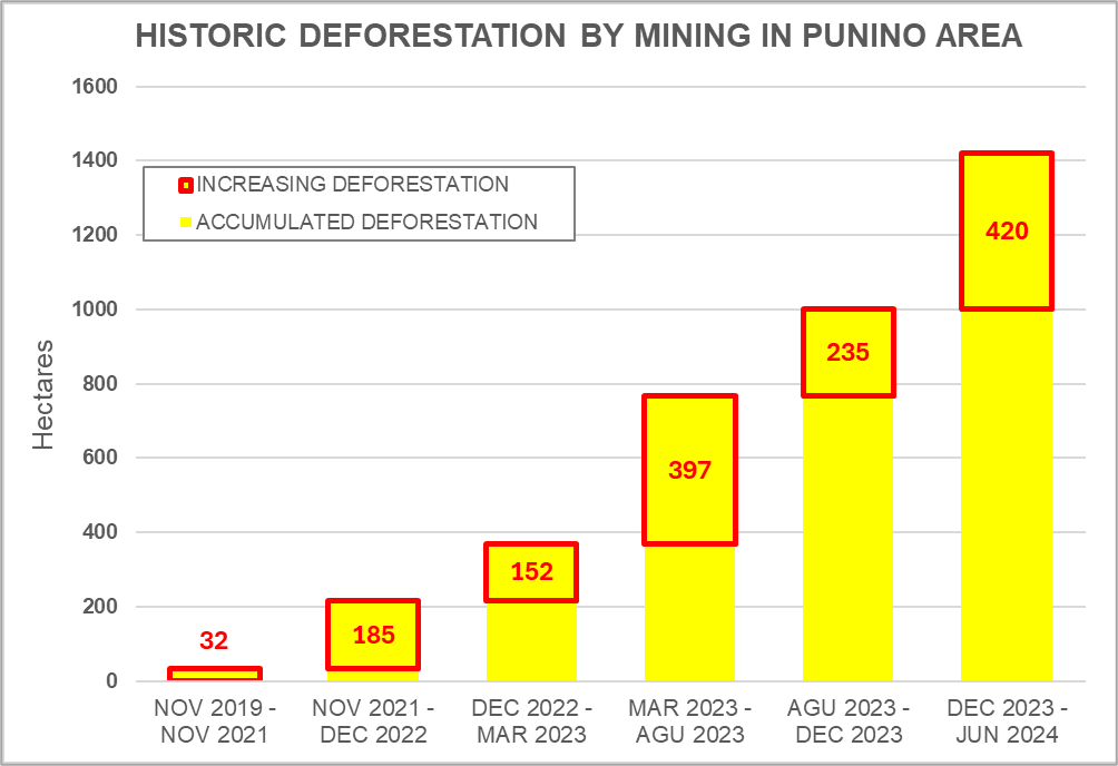
Chart 1. Historical deforestation due to mining in the Punino area between November 2019 and June 2024
Expansion of illegal mining in protected areas
Figure 1 shows the expansion of mining deforestation in and around the two protected areas of the Punino zone. Note that mining has recently penetrated the boundaries of both Sumaco-Napo Galeras National Park (0.32 hectares) and El Chaco Municipal Conservation Area (144 hectares).
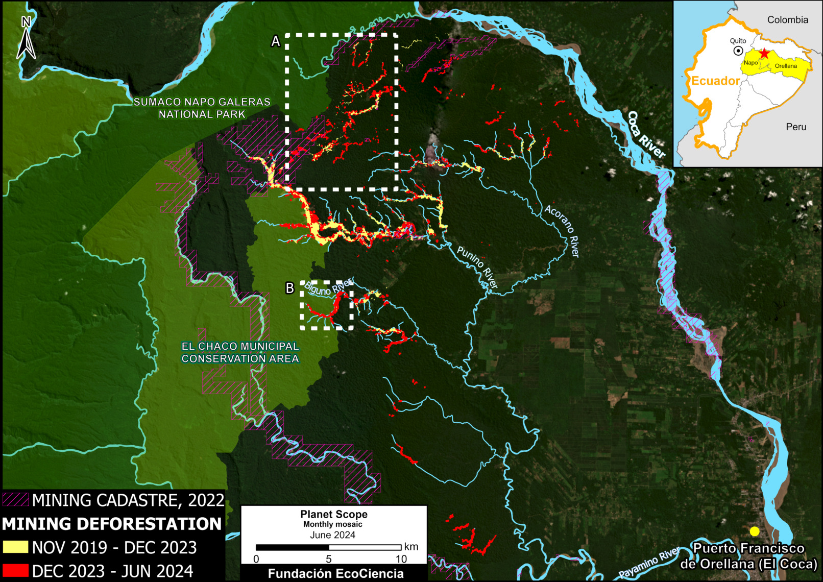
Figure 1. Protected areas affected by mining activity between 2019 and 2024 in the Punino area. Data: ARCERNNR 2022, MAATE 2024, NCI 2018, Planet-NICFI, EcoCiencia.
Figure 2 shows the initial encroachment (0.32 hectares) of mining deforestation in the boundaries of Sumaco Napo-Galeras National Park between September 2022 (left panel) and June 2024 (right panel).
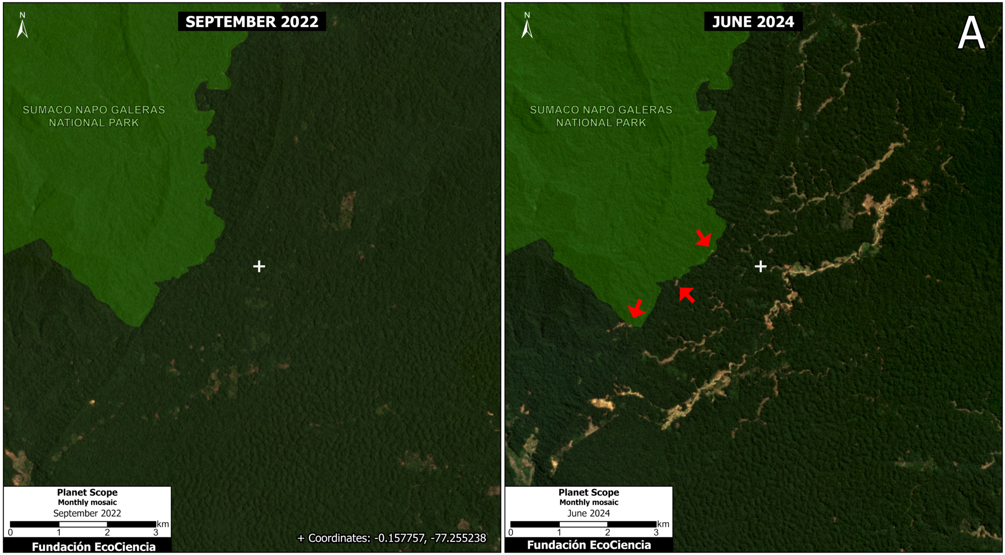
Figure 2. Mining deforestation within the boundaries of Sumaco Napo-Galeras National Park, comparing September 2022 (left panel) with June 2024 (right panel). Data: MAATE 2024, Planet/NICFI, EcoCiencia.
Figure 3 shows the invasion and expansion of deforestation due to mining (144 hectares) within the boundaries of El Chaco Municipal Conservation Area between September 2023 (left panel) and June 2024 (right panel).
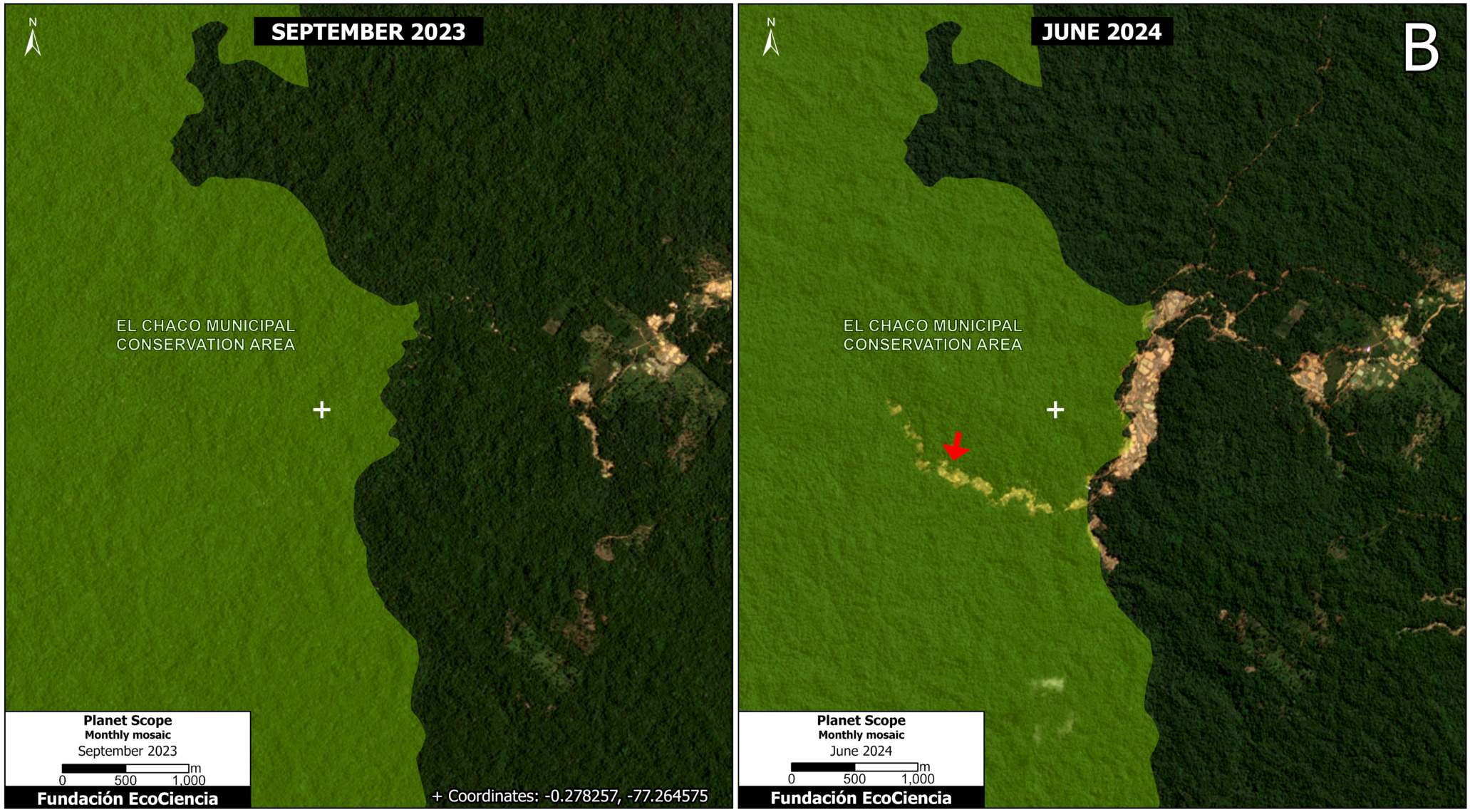
Figure 3. Mining deforestation within the boundaries of the El Chaco Municipal Conservation Area, comparing September 2023 (left panel) with June 2024 (right panel). Data: NCI 2018, Planet/NICFI, Ecociencia.
Expansion of illegal mining in indigenous territories
Figure 4 shows the expansion of mining deforestation (300 hectares) in relation to the Indigenous territories of the Kichwa nationality in the Punino area.
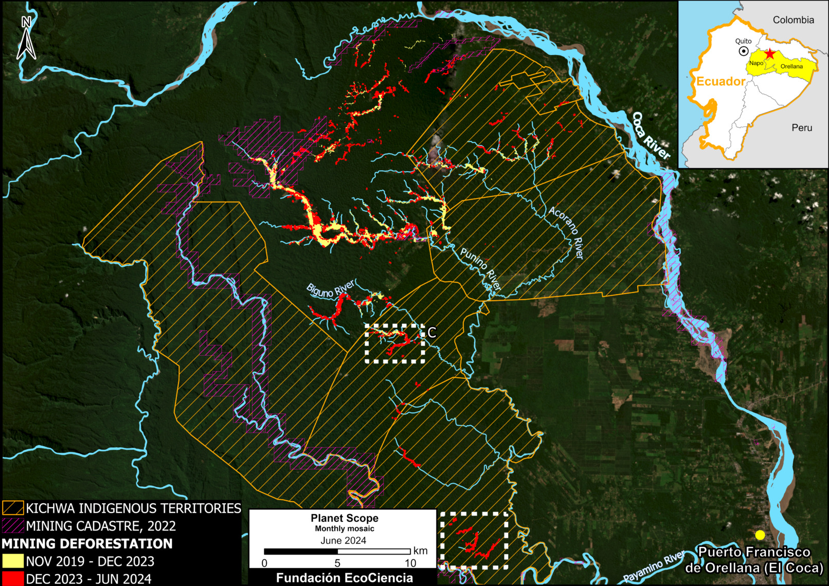
Figure 4. Indigenous territories affected by mining activity between 2019 and 2024 in the Punino area. Data: RAISG 2023, ARCERNNR 2022, Planet-NICFI, EcoCiencia.
Figure 5 shows the expansion of deforestation due to mining in the indigenous territories of the Kichwa nationality between September 2023 (left panel) and June 2024 (right panel).
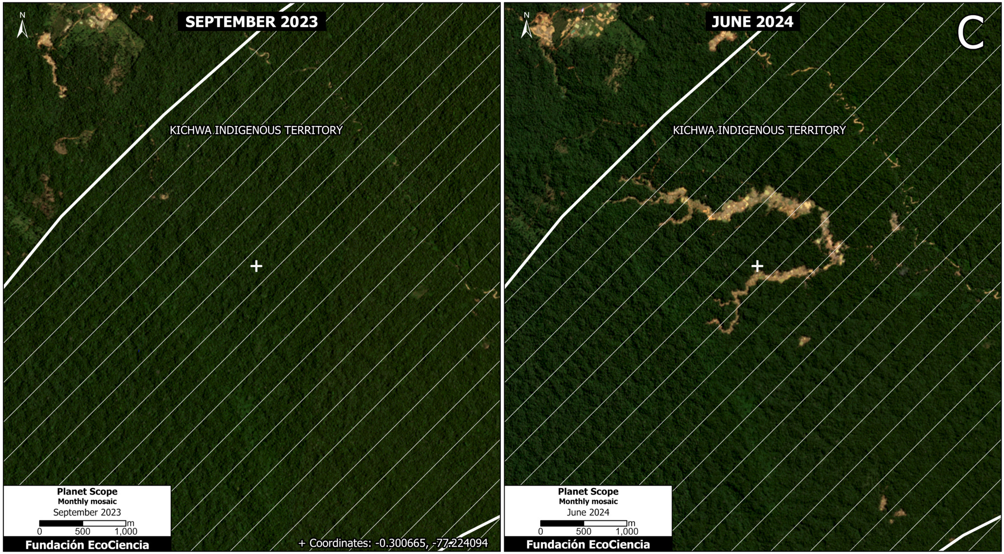
Figure 5. Mining deforestation within indigenous territory of the Kichwa nationality, comparing September 2023 (left panel) with June 2024 (right panel). Data: RAISG 2023, Planet-NICFI, EcoCiencia.
Figure 6 shows the expansion of deforestation due to mining in indigenous territories of the Kichwa nationality south of the study area between November 2019 (left panel) and June 2024 (right panel).
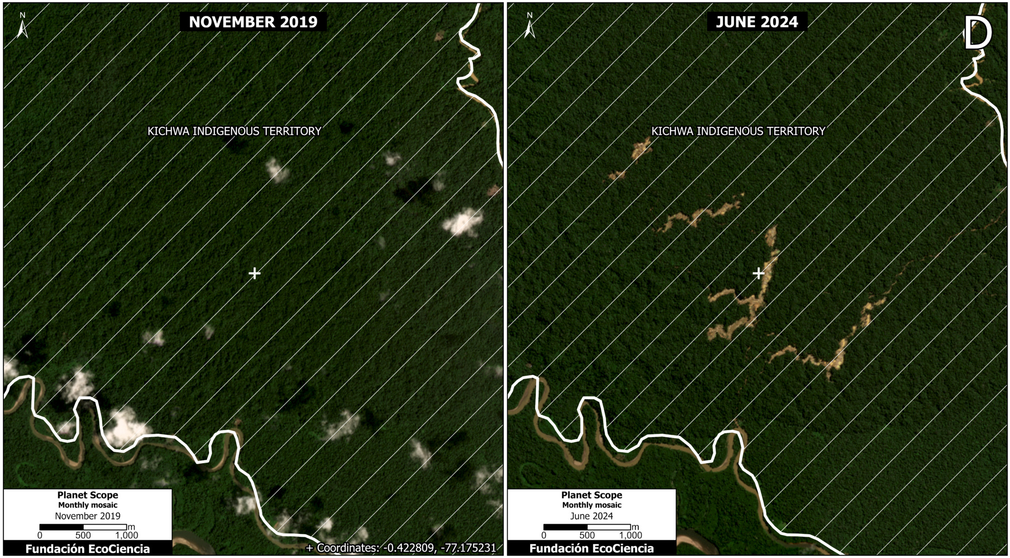
Figure 6. Mining deforestation within indigenous territory of the Kichwa nationality, comparing November 2019 (left panel) with June 2024 (right panel). Data: RAISG 2023, Planet-NICFI, EcoCiencia.
Annex 1
Annex 1 shows the four watersheds impacted by mining activity: the Punino River basin and also the Sardinas River, Lumucha River and Supayacu River basins, which in turn form part of the Coca River macro-water system.
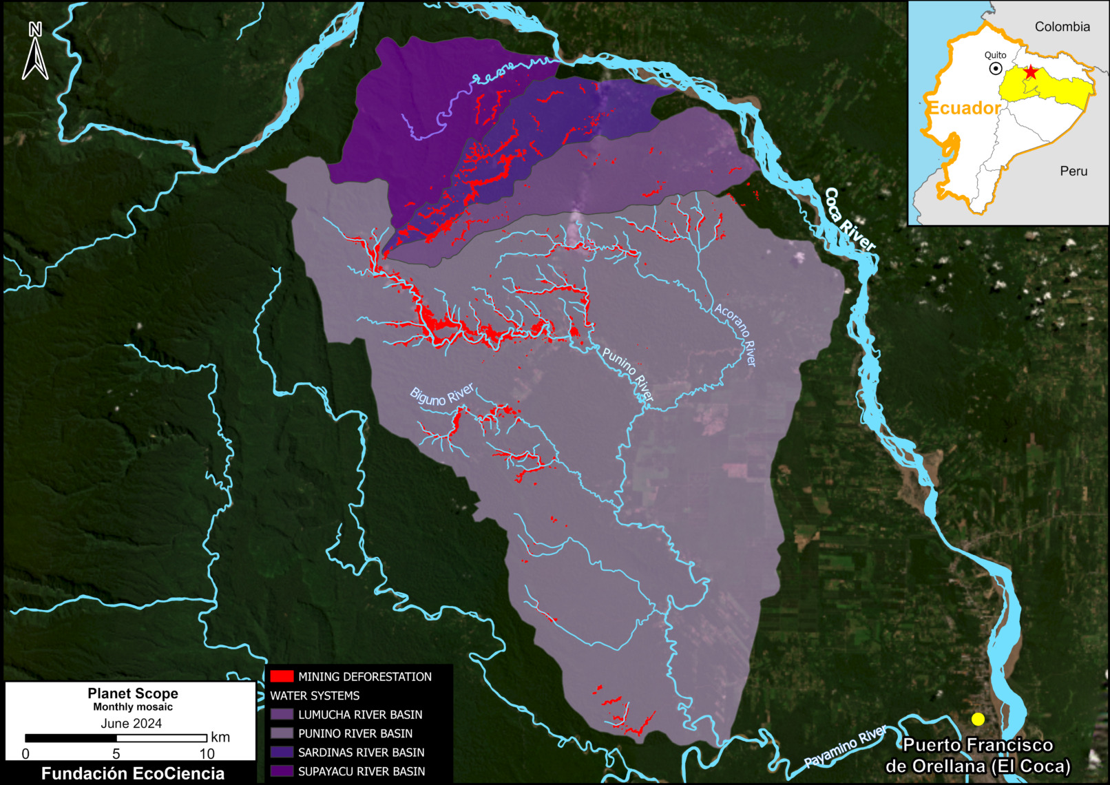
Annex 1. Water systems impacted by mining activity in the Punino area.
Annex 2
Annex 2 shows the construction of 91 kilometers of roads due to mining activity.
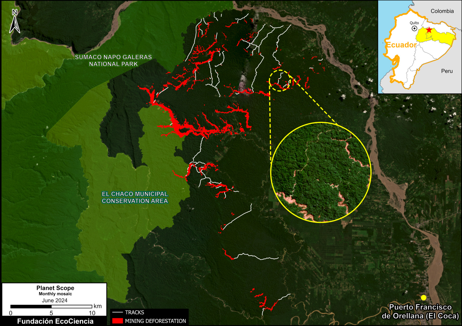
Annex 2. Construction of access roads associated with mining activity.
Acknowledgements
This report is part of a series focused on the Ecuadorian Amazon through a strategic collaboration between the EcoCiencia Foundation and Amazon Conservation, with the support of the Norwegian Agency for Development Cooperation (Norad).

![]()
MAAP #213: Estimating Carbon in Amazon Protected Areas & Indigenous Territories
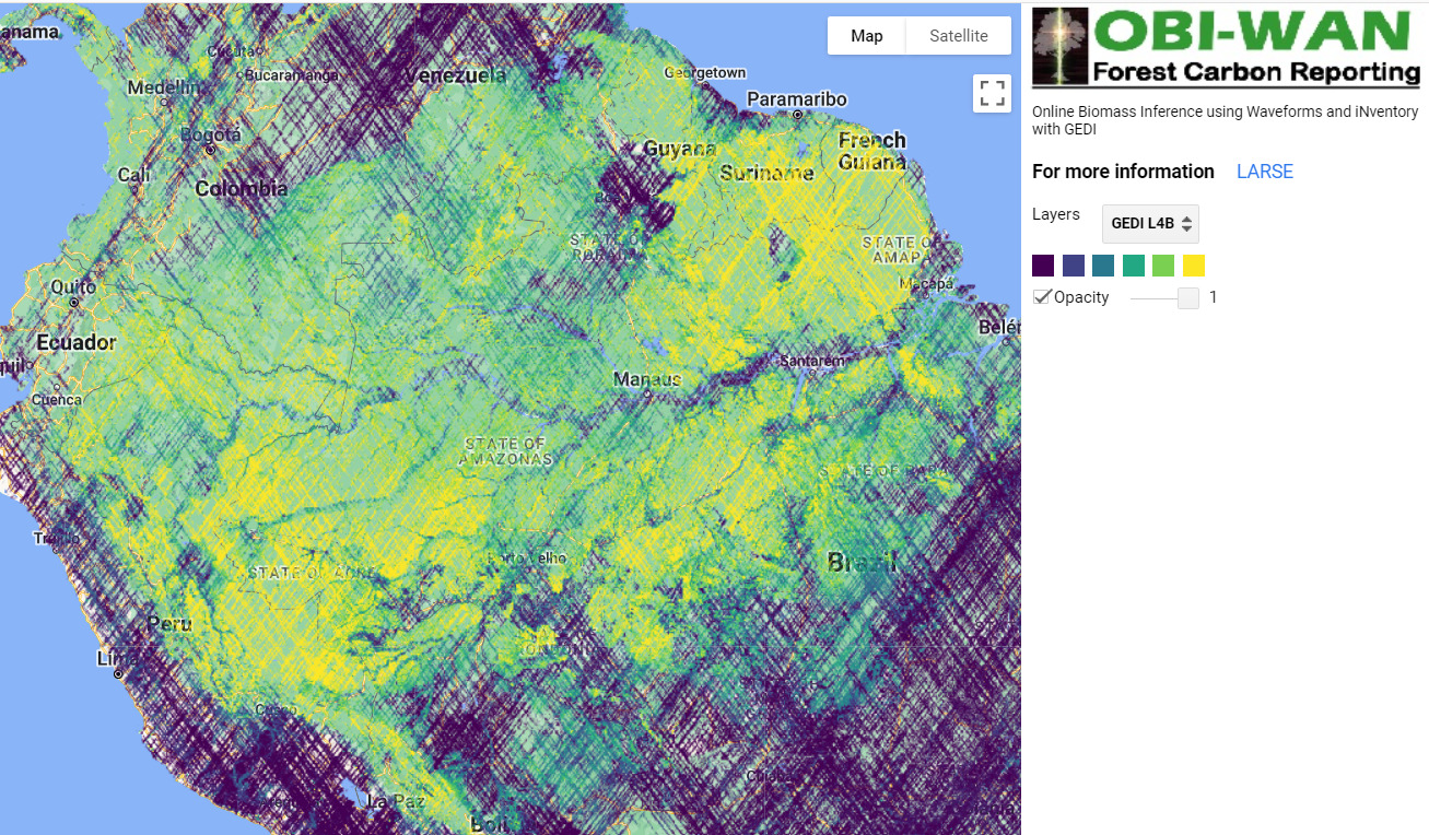
Intro Image. Screenshot of OBI-WAN forest carbon reporting app.
In a recent report (MAAP #199), we presented the updated version of NASA’s GEDI data,1 which uses lasers aboard the International Space Station to provide cutting-edge estimates of aboveground carbon globally, including our focal area, the Amazon.
These lasers, however, have not yet achieved full coverage, leaving considerable gaps in the data and resulting maps.
Here, we feature two new tools that allow us to fill in these gaps and provide detailed wall-to-wall estimates of aboveground biomass for specific areas, which can then be converted to aboveground carbon estimates.
The first is the OBI-WAN forest carbon reporting app (see Intro Image), which uses statistical inference to produce mean, total, and uncertainty estimates for biomass baselines at any given scale (from local to worldwide).2
The second is a fused product from GEDI and TanDEM-X missions.3 The combination of lidar (GEDI) and radar (TanDEM-X) has started to produce unmatched maps that combine the ability of lidar to retrieve forest structure and the ability of radar to offer wall-to-wall coverage at multiple resolutions (see Figures 1-5 below for examples at 25m resolution).
Employing these two tools, we focus on estimating aboveground carbon for select examples of two critical land designations in the Amazon: protected areas and indigenous territories. Both are critical to the long-term conservation of the core Amazon (MAAP #183). We hope that providing precise carbon data will provide additional incentives for their long-term conservation.
We select 5 focal areas (3 National Parks and 2 Indigenous Territories; see list below) across the Amazon to demonstrate the power of these datasets. Together, these five areas are currently home to over 1.4 billion metric tons of aboveground carbon.
- Protected Areas (National Parks)
Chirbiquete National Park (Colombian Amazon)
Manu National Park (Peruvian Amazon)
Madidi National Park (Bolivian Amazon)
k - Indigenous Territories
Kayapó Indigenous Territory (Brazilian Amazon)
Barranco Chico Indigenous Territory (Peruvian Amazon)
Focal Areas
As noted above, the aboveground carbon estimates below are based on the aboveground biomass estimates from the OBI-WAN forest carbon reporting app and GEDI-TanDEM-X data. Figures 1 – 5 are based on GEDI-TanDEM-X, at 25 meter resolution.
National Parks
Chirbiquete National Park (Colombian Amazon)
Chirbiquete National Park covers over 4.2 million hectares in the heart of the Colombian Amazon (Guaviare and Caqueta departments). Both datasets converge in the estimate of around 600 metric tons of aboveground biomass, equating to over 300 million metric tons of aboveground carbon across the park (80.5 tons of carbon per hectare). Figure 1 shows the detailed spatial distribution of this biomass across Chirbiquete National Park. Note that the GEDI-TanDEM-X data misses the western tip of the park.
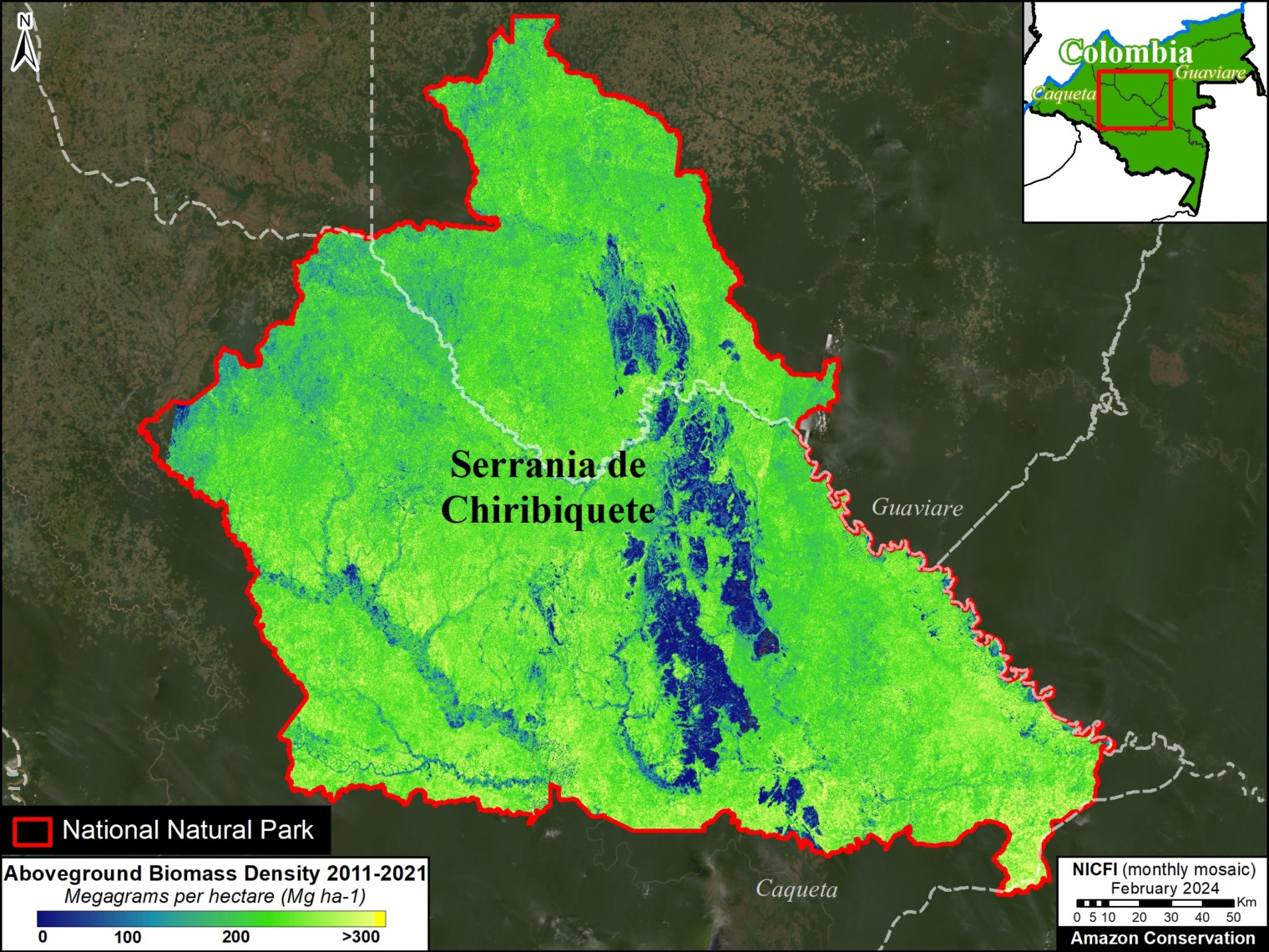
Figure 1. Aboveground biomass across Chiribiquete National Park (Colombian Amazon). Data: GEDI-TanDEM-X
Manu National Park (Peruvian Amazon)
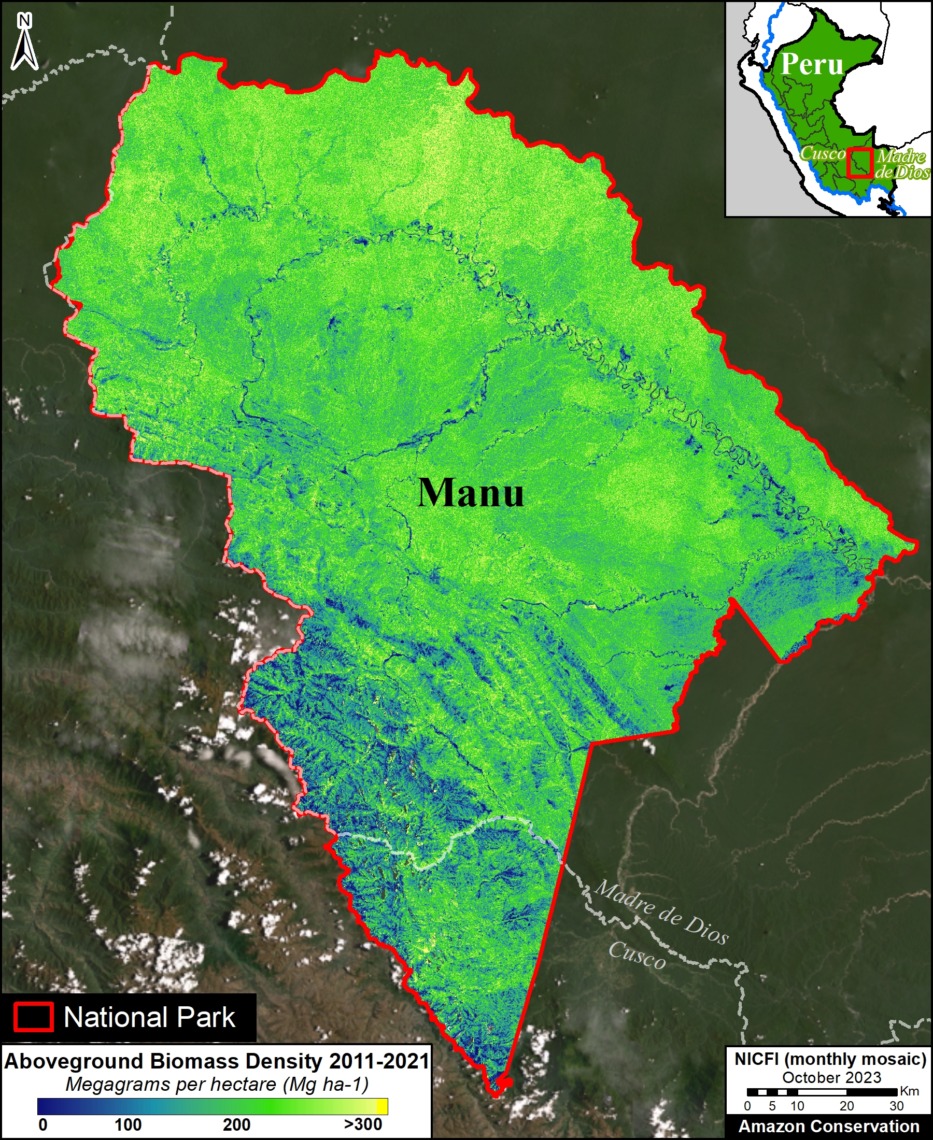
Figure 2. Aboveground biomass across Manu National Park (Peruvian Amazon). Data: GEDI-TanDEM-X
Manu National Park covers over 1.7 million hectares in the southern Peruvian Amazon (Madre de Dios and Cusco regions).
Both datasets converge in the estimate of over 450 metric tons of aboveground biomass, equating to over 215 million metric tons of aboveground carbon across the territory (126.8 tons of carbon per hectare).
Figure 2 shows the detailed spatial distribution of this biomass across Manu National Park.
Madidi National Park (Bolivian Amazon)
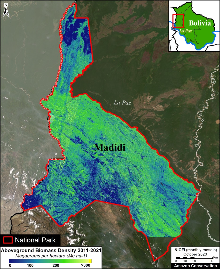
Figure 3. Aboveground biomass across Madidi National Park (Bolivian Amazon). Data: GEDI-TanDEM-X
Madidi National Park and Integrated Management Area covers over 1.8 million hectares in the western Bolivian Amazon (La Paz department).
Both datasets converge in the estimate of over 350 metric tons of aboveground biomass, equating to over 160 million metric tons of aboveground carbon across the park (85.3 tons of carbon per hectare).
Figure 3 shows the detailed spatial distribution of this biomass across Madidi National Park. Note that the GEDI-TanDEM-X data misses the southern tip of the park.
Indigenous Territories
Kayapó Indigenous Territory (Brazilian Amazon)
Kayapó Indigenous Territory covers over 3.2 million hectares in the eastern Brazilian Amazon (Pará state). Both datasets converge in the estimate of over 413,000 metric tons of aboveground biomass, equating to over 198 million metric tons of aboveground carbon across the territory. Figure 4 shows the detailed spatial distribution of this biomass across Kayapó and four neighboring Indigenous Territories. Totaling across these five territories (10.4 million hectares), the data sets converge on over 1.5 billion metric tons of aboveground biomass, and 730 million metric tons of aboveground carbon (70 tons per hectare).
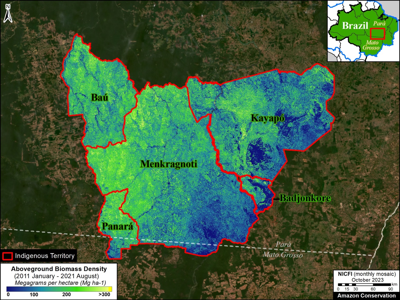
Figure 4. Aboveground biomass across Kayapó and neighboring Indigenous Territories (Brazilian Amazon). Data: GEDI-TanDEM-X
Barranco Chico Indigenous Territory (Peruvian Amazon)
Barranco Chico Indigenous Territory covers over 12,600 hectares in the southern Peruvian Amazon (Madre de Dios region). Both datasets converge in the estimate of over 2 million metric tons of aboveground biomass, equating to over 1 million metric tons of aboveground carbon. Figure 5 shows the detailed spatial distribution of this biomass across Barranco Chico and two neighboring Indigenous Territories (Puerto Luz and San Jose de Karene). Totaling across these three territories (nearly 90,000 hectares), the data sets converge on over 19 million metric tons of aboveground biomass, and over 9 million metric tons of aboveground carbon (102 tons per hectare).
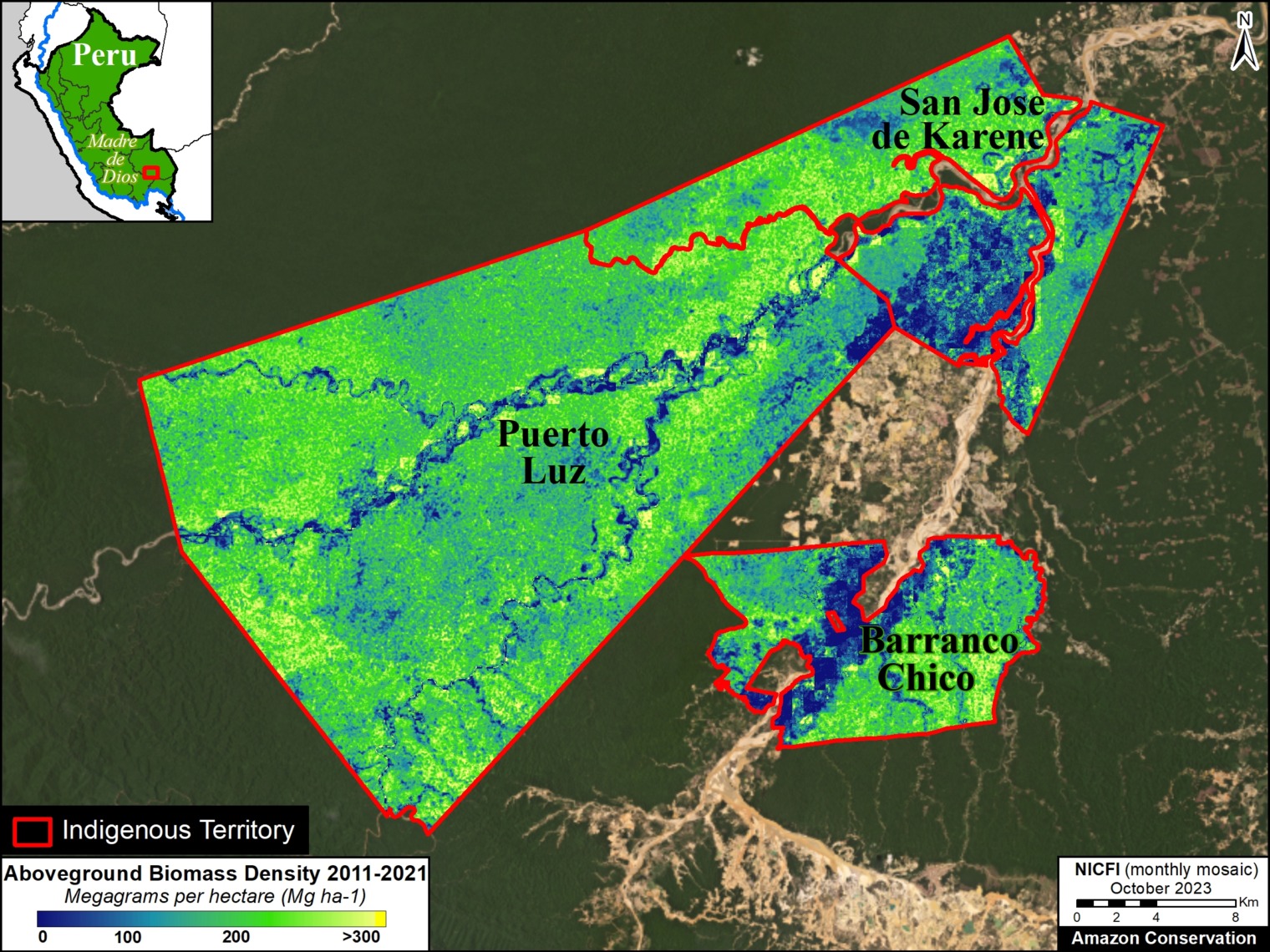
Figure 5. Aboveground biomass across Barranco Chico and neighboring Indigenous Territories (Peruvian Amazon). Data: GEDI-TanDEM-X
Notes
1 GEDI L4B Gridded Aboveground Biomass Density, Version 2.1. This data is measured in megagrams of aboveground biomass per hectare (Mg/ha) at a 1-kilometer resolution, with the period of April 2019 – March 2023. This serves as our estimate for aboveground carbon reserves, with the science-based assumption that 48% of recorded biomass is carbon.
2 The approach relies on the foundational paper from Patterson et al., (2019) and it is used by the GEDI mission to estimate mean and total biomass worldwide (Dubayh et al., 2022, Armston et al., 2023). The method considers the spatial distribution of GEDI tracks within a given user-specify boundary to infer the sampling error component of the total uncertainty that also includes the error from the GEDI L4A models used to predict biomass from canopy height estimates (Keller et al., 2022). For more information on the OBI-WAN app, see Healey and Yang 2022.
3 GEDI-TanDEM-X (GTDX) is a fusion of GEDI Version 2 and TanDEM-X (TDX) Interferometric Synthetic Aperture Radar (InSAR) images (from Jan 2011 to December 2020). It also incorporates annual forest loss data to account for deforestation during this time. The GTDX aboveground biomass maps were produced based on a generalized hierarchical model-based (GHMB) framework that utilizes GEDI biomass as training data to establish models for estimating biomass based on the GTDX canopy height. The combination of lidar (GEDI) and radar (TanDEM-X) has started to produce unmatched maps that combine the ability of lidar to retrieve forest structure and the ability of radar to offer wall-to-wall coverage (Qi et al.,2023, Dubayah et a;., 2023). This fused product is a wall-to-wall gap-free map that was produced at multiple resolutions: 25m, 100m and 1ha. Ongoing processing over the Pantropic region will be made available over the next months but some geographies have been already mapped such as most of the Amazon Basin (Dubayah et al., 2023). The data we used is publicly available.
References
Armston, J., Dubayah, R. O., Healey, S. P., Yang, Z., Patterson, P. L., Saarela, S., Stahl, G., Duncanson, L., Kellner, J. R., Pascual, A., & Bruening, J. (2023). Global Ecosystem Dynamics Investigation (GEDI)GEDI L4B Country-level Summaries of Aboveground Biomass [CSV]. 0 MB. https://doi.org/10.3334/ORNLDAAC/2321
Dubayah, R. O., Armston, J., Healey, S. P., Yang, Z., Patterson, P. L., Saarela, S., Stahl, G., Duncanson, L., Kellner, J. R., Bruening, J., & Pascual, A. (2023). Global Ecosystem Dynamics Investigation (GEDI)GEDI L4B Gridded Aboveground Biomass Density, Version 2.1 [COG]. 0 MB. https://doi.org/10.3334/ORNLDAAC/2299
Dubayah, R., Armston, J., Healey, S. P., Bruening, J. M., Patterson, P. L., Kellner, J. R., Duncanson, L., Saarela, S., Ståhl, G., Yang, Z., Tang, H., Blair, J. B., Fatoyinbo, L., Goetz, S., Hancock, S., Hansen, M., Hofton, M., Hurtt, G., & Luthcke, S. (2022). GEDI launches a new era of biomass inference from space. Environmental Research Letters, 17(9), 095001. https://doi.org/10.1088/1748-9326/ac8694
Dubayah, R., Blair, J. B., Goetz, S., Fatoyinbo, L., Hansen, M., Healey, S., Hofton, M., Hurtt, G., Kellner, J., Luthcke, S., Armston, J., Tang, H., Duncanson, L., Hancock, S., Jantz, P., Marselis, S., Patterson, P. L., Qi, W., & Silva, C. (2020). The Global Ecosystem Dynamics Investigation: High-resolution laser ranging of the Earth’s forests and topography. Science of Remote Sensing, 1, 100002. https://doi.org/10.1016/j.srs.2020.100002
Healey S, Yang Z (2022) The OBIWAN App: Estimating Property-Level Carbon Storage Using NASA’s GEDI Lidar. https://www.fs.usda.gov/research/rmrs/understory/obiwan-app-estimating-property-level-carbon-storage-using-nasas-gedi-lidar
Kellner, J. R., Armston, J., & Duncanson, L. (2022). Algorithm Theoretical Basis Document for GEDI Footprint Aboveground Biomass Density. Earth and Space Science, 10(4), e2022EA002516. https://doi.org/10.1029/2022EA002516
Dubayah, R.O., W. Qi, J. Armston, T. Fatoyinbo, K. Papathanassiou, M. Pardini, A. Stovall, C. Choi, and V. Cazcarra-Bes. 2023. Pantropical Forest Height and Biomass from GEDI and TanDEM-X Data Fusion. ORNL DAAC, Oak Ridge, Tennessee, USA. https://doi.org/10.3334/ORNLDAAC/2298
Qi, W., J. Armston, C. Choi, A. Stovall, S. Saarela, M. Pardini, L. Fatoyinbo, K. Papathanasiou, and R. Dubayah. 2023. Mapping large-scale pantropical forest canopy height by integrating GEDI lidar and TanDEM-X InSAR data. Research Square. https://doi.org/10.21203/rs.3.rs-3306982/v1
Krieger, G., M. Zink, M. Bachmann, B. Bräutigam, D. Schulze, M. Martone, P. Rizzoli, U. Steinbrecher, J. Walter Antony, F. De Zan, I. Hajnsek, K. Papathanassiou, F. Kugler, M. Rodriguez Cassola, M. Younis, S. Baumgartner, P. López-Dekker, P. Prats, and A. Moreira. 2013. TanDEM-X: A radar interferometer with two formation-flying satellites. Acta Astronautica 89:83–98. https://doi.org/10.1016/j.actaastro.2013.03.008
Acknowledgments
We greatly thank the University of Maryland’s GEDI team for data access and reviewing this report. In particular, we thank Ralph Dubayah, Matheus Nunes, and Sean Healey.
This report was made possible by the generous support of the Norwegian Agency for Development Cooperation (NORAD)
![]()
Citation
Mamani N, Pascual A, Finer M (2024) Estimating Carbon in Amazon Protected Areas & Indigenous Territories. MAAP: 213