MAAP #171: Deforestation in Mining Corridor of Peruvian Amazon (2021-2022)


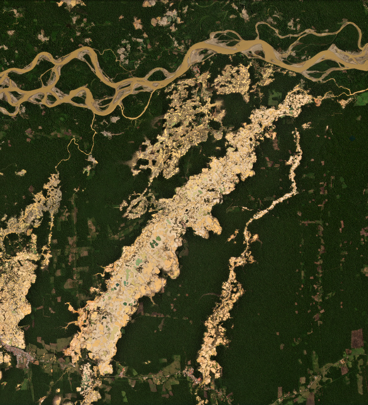
Figure 1. Recent mining deforestation in the Guacamayo zone of the Mining Corridor (Madre de Dios region of the southern Peruvian Amazon). Data: Planet.
Gold mining continues to be one of the main deforestation drivers in the southern Peruvian Amazon (Madre de Dios region).
In a recent report (MAAP #154), we highlighted the key cases of illegal mining in this area.
In an attempt to organize mining activities and promote a formalization process,* the Peruvian government has delimited a large Mining Corridor in Madre de Dios (see Base Map below).
Here, we analyze recent (2021 – 2022) deforestation in the Mining Corridor, using a novel methodology.
Deforestation within its limits is important because, although it may not be illegal, can be considerable due to the large area covered by the Mining Corridor (498,296 hectares, or 1.2 million acres).
The key part of this analysis is the novel ability to distinguish mining deforestation from agriculture deforestation, which is also common in the area.
In summary, we estimate the direct mining deforestation of 11,200 hectares (27,675 acres) in the Mining Corridor over the last two years (2021-22).
Deforestation in the Mining Corridor
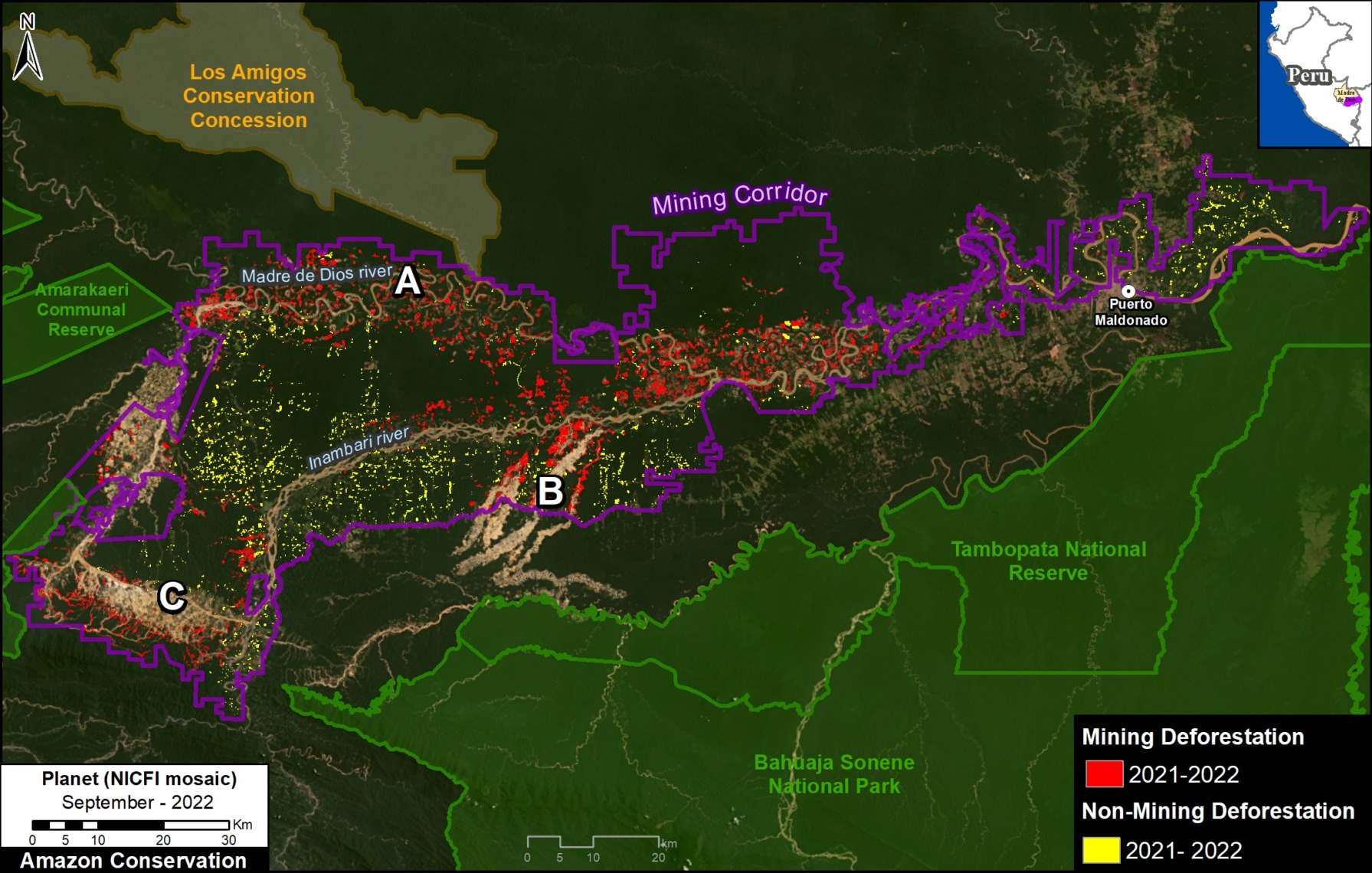
Base Map. Mining (red) vs Agriculture (yellow) deforestation within the Mining Corridor in the southern Amazon of Peru (Madre de Dios region), during the years 2021 and 2022. Data: ACCA/MAAP.
We found a total deforestation of 16,000 hectares (39,500 acres) within the Mining Corridor over the past two years (2021 and 2022).
Of this deforestation total, 70% is directly linked to gold mining (11,200 hectares; indicated by red on the Base Map), while the remaining 30% loss is agricultural expansion (4,800 hectares; indicated by yellow).
In the Base Map, note that mining deforestation is largely concentrated in three general areas:
(A) along the Madre Dios River, (B) the Guacamayo mining zone (also see Figure 1, above), and (C) around the perimeter of the Huepetuhe mining zone.
*Note on the mining formalization process in Peru
In the Mining Corridor, officially called the “Zona de pequeña minería y minería artesanal en el departamento de
Madre de Dios,” declared by Legislative Decree No. 1100, mining activities can be classified into one of three scenarios:
1) Formal: Formalization process completed, with approved environmental and operational permits.
2) Informal: In the process of being formalized, operating in spaces where extraction is allowed and using permitted machinery. This type is considered an administrative offense, not a crime.
3) Illegal: Operating in prohibited areas such as bodies of water (for example, a river or a lake) and/or using prohibited machinery. This type is considered a crime and is punishable by jail.
Methodology
We used LandTrendr, a temporal segmentation algorithm that identifies changes in pixel values through time, to detect forest loss within the mining corridor in 2021 (September 2020 – September 2021) and 2022 (September 2021 – July 2022). It is important to emphasize this method was originally designed for moderate-resolution (30 meters) Landsat imagery,1 but we adapted it for higher-resolution (4.7 meters) NICFI-Planet monthly mosaics.2
Additionally, we created a baseline for the period 2016- 2020 to eliminate old agriculture and mining areas (pre-2021) due to rapid changes in the natural re-vegetation process.
Finally, we manually separated the mining and non-mining forest loss for 2021 and 2022, in order to report specifically on direct mining-related impacts. For this part of the analysis, we used various resources to aid the manual process, such as radar-based alerts (RAMI), CINCIA historical data from 1985 to 2020, and forest loss data from the Peruvian government (PNCB) and the University of Maryland.
Acknowledgments
We thank S. Otoya for helpful comments on this report.
This report was conducted with technical assistance from USAID, via the Prevent project. Prevent works with the Government of Peru, civil society and the private sector to prevent and combat environmental crimes for the sake of the conservation of the Peruvian Amazon, particularly in the regions of Loreto, Madre de Dios and Ucayali.
This publication is made possible with the support of the American people through USAID. Its content is the sole responsibility of the authors and does not necessarily reflect the views of USAID or the US government.
![]()
Citation
Mamani N, Finer M (2022) Deforestation in Mining Corridor of Peruvian Amazon (2021-2022). MAAP: 171.
Download PDF of this article