MAAP #195: Gold Mining Deforestation in the Southern Peruvian Amazon, 2021-2023


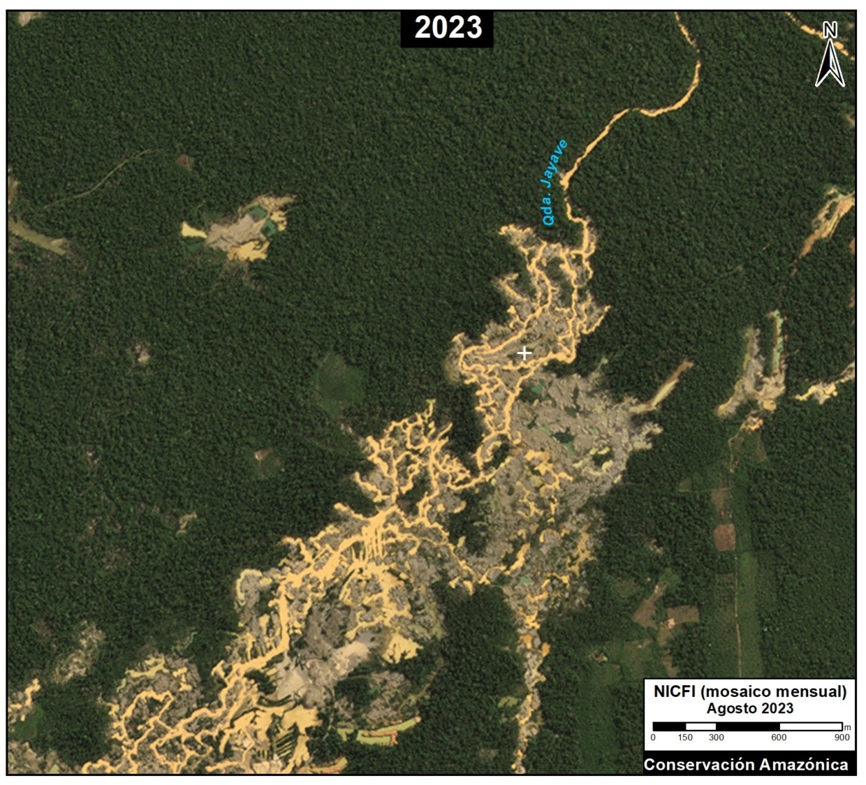
Figure 1. Recent deforestation in the Mining Corridor of the Madre de Dios region in the southern Peruvian Amazon (Guacamayo zone). Data: Planet.
In the context of overall Amazon gold mining, where illegal mining is rampant, southern Peru is an important case study given that the government has created the “Mining Corridor“, where mining is allowed in order to organize and promote this activity.
In this large area, officially known as the “Zone of small-scale and artisanal mining in the department of Madre Dios,” mining activity can be formal, informal, or illegal, depending on the location and legal compliance (see more details in the Notes section).
Knowing the level of mining deforestation that occurs within its limits is important because, although it may not be illegal, it can be considerable given that the Mining Corridor covers a large area of almost half a million hectares (498,296 ha).
Indeed, we estimate the mining deforestation of 18,174 hectares within the Mining Corridor over the last three years (2021-2023).
In addition, we identified the mining deforestation of 5,707 hectares outside the Mining Corridor, that is, in prohibited areas and thus likely illegal mining.
Consequently, we found a total mining deforestation of 23,881 hectares (59,011 acres) during this period (2021-2023) in southern Peru.
Of this total, 76% of the deforestation occurred within the Mining Corridor, while the remaining 24% corresponds to surrounding illegal mining.
Base Map: Mining Deforestation in the Southern Peruvian Amazon
The Base Map highlights the most recent mining deforestation in the years 2021-2023 (shown in red) in relation to the historical loss of forests in the area (shown in black), both inside and outside the Mining Corridor.
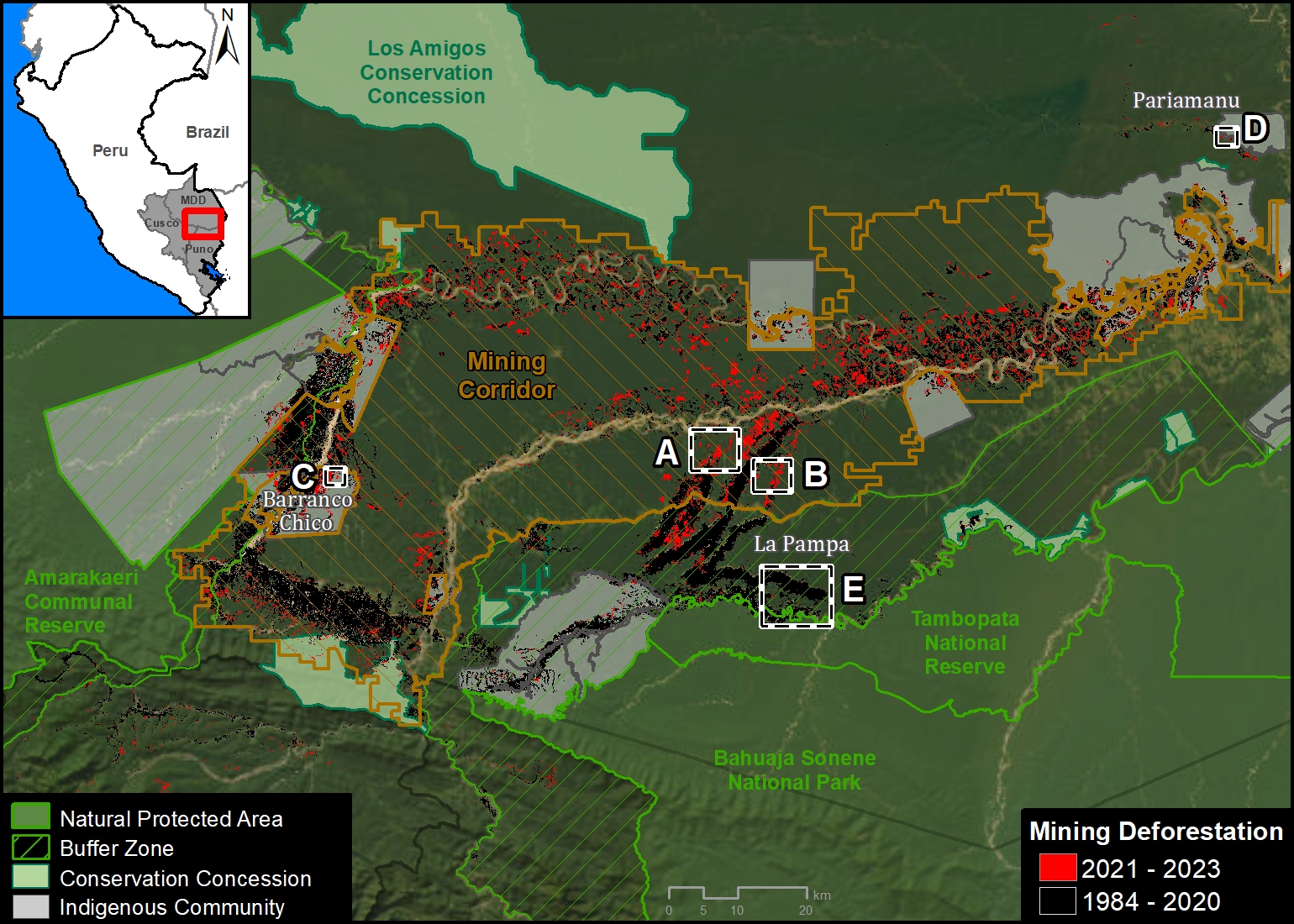
Base Map. Mining deforestation inside and outside the Madre de Dios Mining Corridor, in the southern Amazon of Peru, during the years 2021 and 2023. Data: ACCA/MAAP.
Note that mining deforestation is concentrated within the Mining Corridor, representing 76% of the total. This is especially evident in the Guacamayo mining area (See Zooms A and B) and along the Madre Dios River.
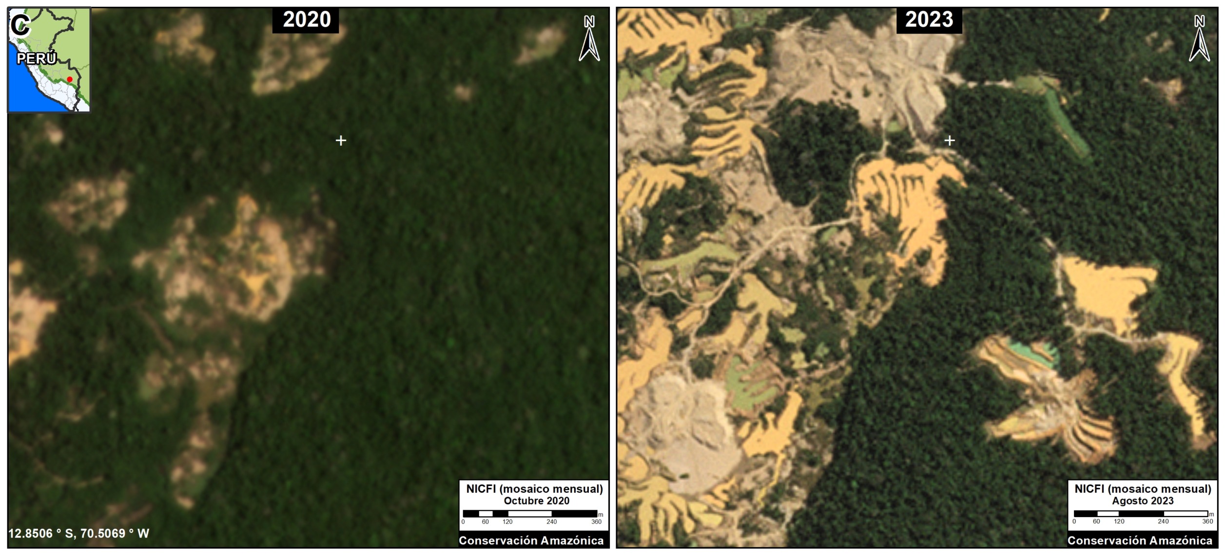
The rest of the mining deforestation (24%) is outside the Mining Corridor. The majority of this deforestation is occurring in the 10 Indigenous Communities of the area, covering 3,406 hectares. The most affected communities are Barranco Chico (Zoom C), San José de Karene, Tres Islas, and Kotsimba.
Mining deforestation has also been identified in buffer zones of protected natural areas. The most affected are Tambopata National Reserve, Bahuaja Sonene National Park and Amarakaeri Communal Reserve. However, it must be emphasized that mining within protected natural areas has been effectively controlled by the Peruvian State, through the National Service of Protected Natural Areas (SERNANP).
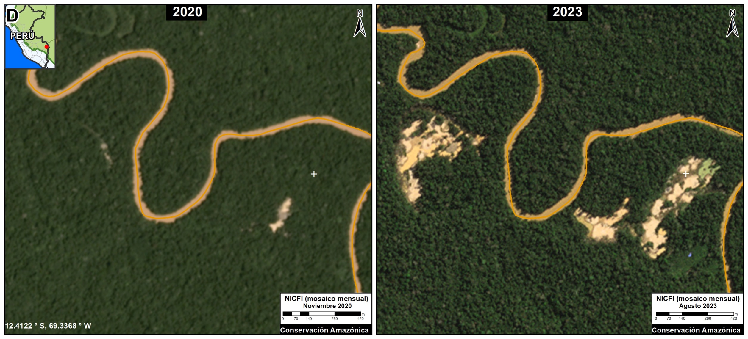
Additionally, a certain amount of mining deforestation (161 hectares) has been detected in Brazil nut forest concessions located in the Pariamanu area (Zoom D).
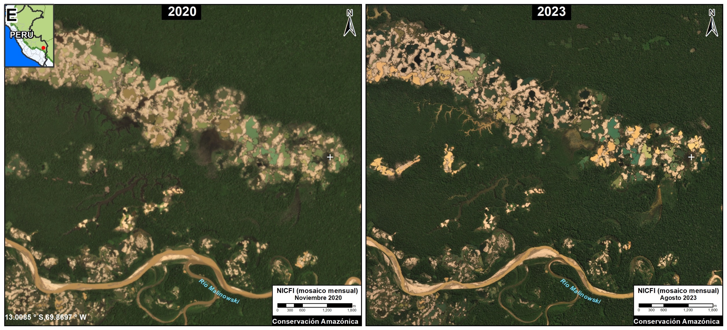
Finally, it is worth mentioning an area of importance in the buffer zone of Tambopata National Reserve, known as La Pampa (Zoom E). This area was the epicenter of destructive mining deforestation between 2014 and 2018. However, the imagery reveals that after Operation Mercurio, which began in early 2019, the expansion of mining deforestation in La Pampa basically stopped. Despite this, a recent report has shown a large increase in mining activity in previously deforested areas of La Pampa (MAAP #193).
High Resolution Zooms (A-E)
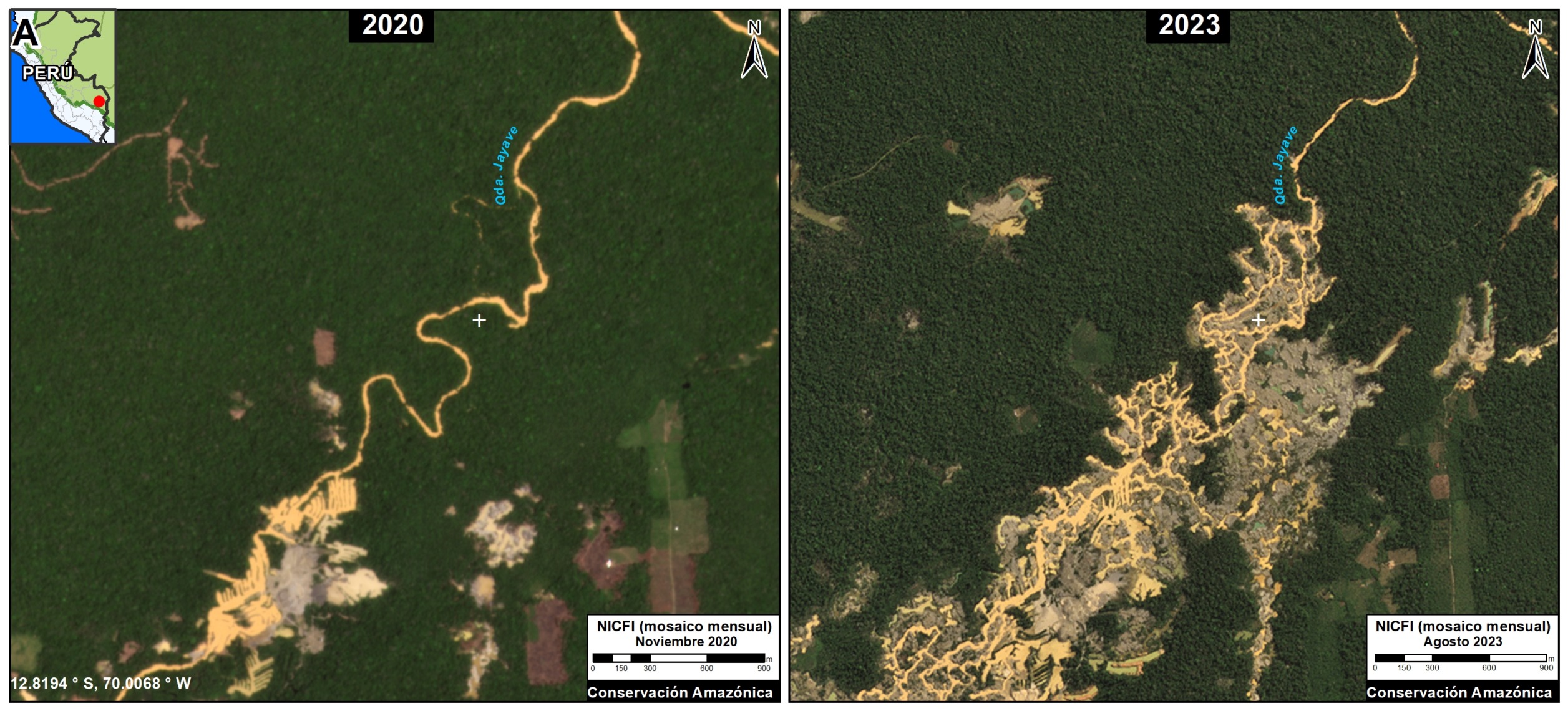
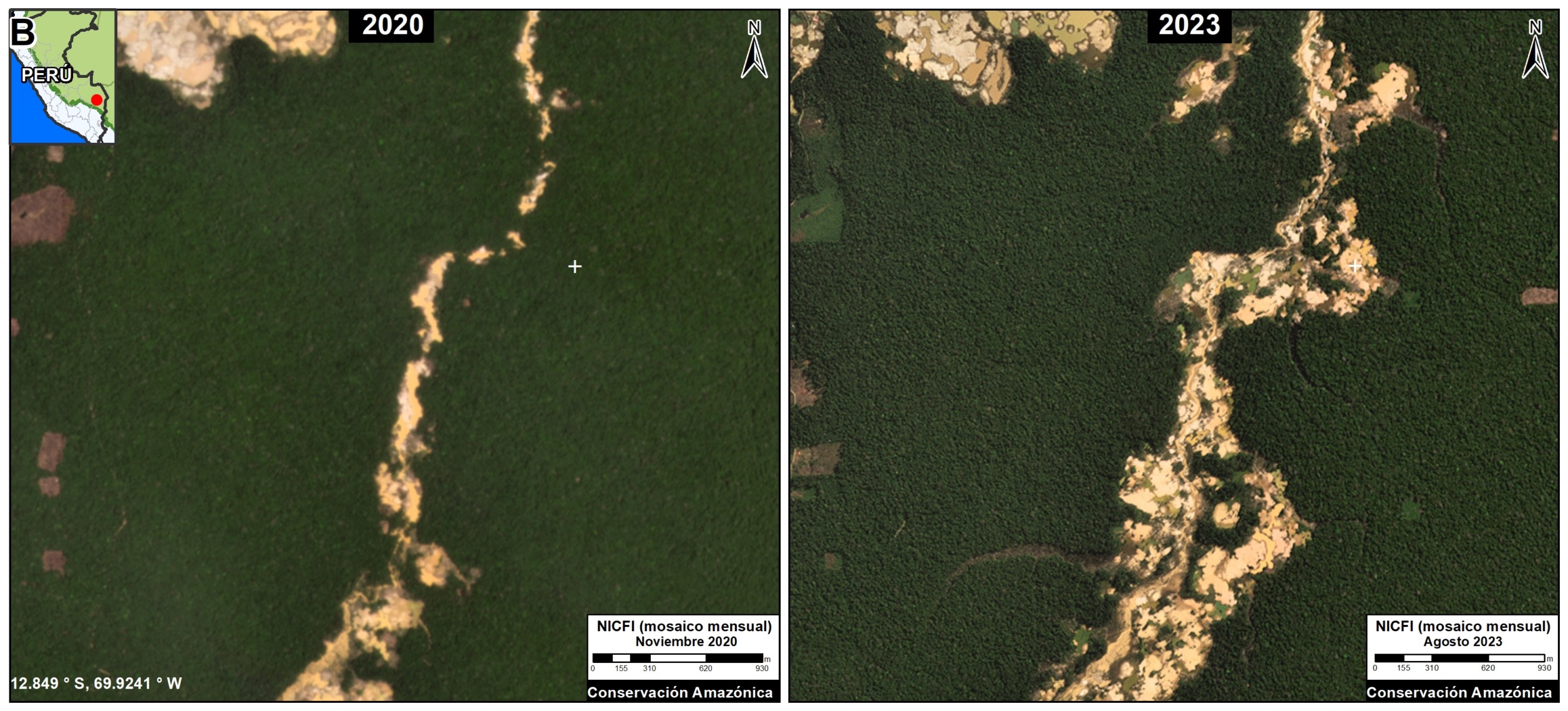
The following high-resolution zooms compare mining deforestation between the year 2020 (left panel) and the current time period of 2023 (right panel). Zooms A and B are located inside the Mining Corridor (Guacamayo area), while Zooms C-E are located outside.
Zoom A. Mining Corridor (Guacamayo zone – west)
Zoom B. Mining Corridor (Guacamayo zone – east)
Zoom C. Barranco Chico Indigenous Community
Zoom D. Brazil Nut Concession, Pariamanu zone
Zoom E. La Pampa
Notes
The Mining Corridor, designated by Legislative Decree No. 1100 as the “Zone for small-scale and artisanal mining in the department of Madre de Dios,” categorizes mining activities as follows:
- Formal: Completed formalization process with approved environmental and operational permits.
- Informal: In the process of formalization; Operates only in authorized extraction areas, uses permitted machinery, and is considered an administrative offense, not a crime.
- Illegal: Operates in prohibited areas such as bodies of water (e.g., rivers or lakes), uses prohibited machinery, is considered a criminal offense, and is punishable by imprisonment.
Methodology
We used LandTrendR, a temporal segmentation algorithm that identifies changes in pixel values over time, to detect forest loss within the Mining Corridor between 2021 and 2023 using the Google Earth Engine platform. It is important to note that this method was originally designed for Landsat images with moderate resolution (30 meters)1, but we adapted it for higher spatial resolution NICFI-Planet monthly mosaics (4.7 meters).2
Additionally, we created a baseline for the period 2016-2020 to eliminate old deforested areas (prior to 2021) due to rapid changes in the natural regrowth process.
Finally, we manually separated forest loss due to mining and other causes between 2021 and 2023 to specifically report on direct impacts related to mining. For this part of the analysis, we used various resources to aid the manual process, such as radar image alerts (RAMI) from the SERVIR Amazonia program, historical data from CINCIA from 1985 to 2020, forest loss data from the Peruvian government (National Forest Conservation Program for Climate Change Mitigation), and the University of Maryland.
- Kennedy, R.E., Yang, Z., Gorelick, N., Braaten, J., Cavalcante, L., Cohen, W.B., Healey, S. (2018). Implementation of the LandTrendr Algorithm on Google Earth Engine. Remote Sensing. 10, 691.
- Erik Lindquist, FAO, 2021
Acknowledgements
This report was prepared with the technical support of USAID through the Prevent Project. Prevent (Proyecto Prevenir in Spanish) works with the Government of Peru, civil society, and the private sector to prevent and combat environmental crimes for the conservation of the Peruvian Amazon, particularly in the regions of Loreto, Madre de Dios, and Ucayali.
Disclaimer: This publication is made possible by the generous support of the American people through USAID. The contents are the sole responsibility of the authors and do not necessarily reflect the views of USAID or the United States Government.
Citation
Finer M, Mamani N, Ariñez A (2023) Gold Mining Deforestation in the Southern Peruvian Amazon, 2021-2023. MAAP: 195.
Download PDF of this article