MAAP #185: Gold Mining Deforestation in the Southern Peruvian Amazon: 2021-2022 Update


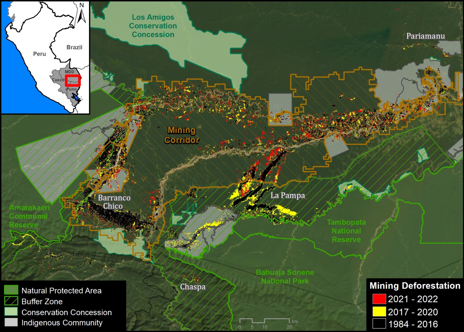
Base Map. Gold Mining Deforestation in the Southern Peruvian Amazon, 2021-2022 update. Zooms indicated by insets A-F. Click on image to enlarge. Data: ACA/MAAP, CINCIA.
Gold mining continues to be one of the main causes of deforestation in the southern Peruvian Amazon, especially in the Madre de Dios region.
Here, we provide a comprehensive look at the most recent (2021-2022) gold mining-related deforestation in the area, combining two important types of data for the first time:
- Deforestation within the Mining Corridor, a large area delimited by the Peruvian government to organize and promote mining. Mining activity in this corridor, officially known as the “Small-scale and Artisanal Mining Zone in the department of Madre de Dios,” can be formal, informal, or illegal.1
j - Deforestation outside the Mining Corridor, which represents our estimate of illegal mining. According to current regulations (Legislative Decree No. 1336), illegal mining occurs in one or more territorial categories such as protected natural areas, indigenous reserves, and natural bodies of water (such as lakes or rivers). Therefore, for this report, the presence of mining-related deforestation in protected natural areas and their buffer zones, as well as indigenous communities, is considered an indicator of illegality. However, it is important to recognize the possibility that some of these findings may be covered by current regulations regarding mining formalization.2 Therefore, it is recommended to consider the findings of illegal deforestation as referential.
These two study areas cover a total of 1.38 million hectares and include all detected mining areas in the southern Peruvian Amazon.
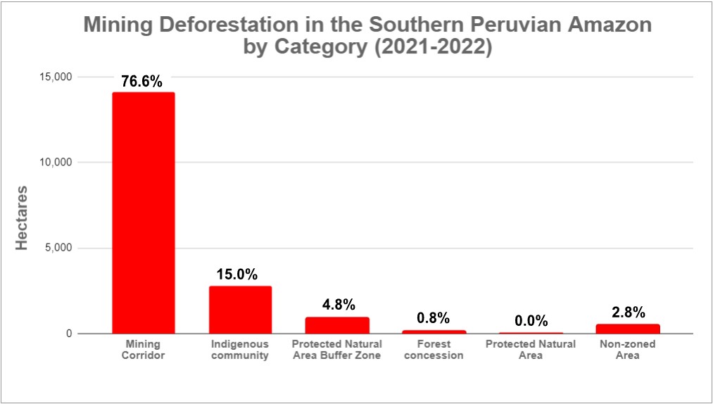
We highlight several important findings (see Base Map and Table 1):
-

Table 1. Data: ACA/MAAP.
We estimate a total deforestation of 18,421 hectares (45,520 acres) due to gold mining in the southern Peruvian Amazon in the last two years (2021-2022).
l - Of this total, the majority of mining-related deforestation (76.6%, or 14,117 hectares) occurred within the Mining Corridor.
l - The remaining deforestation (23.4%, or 4,304 hectares) took place outside the Mining Corridor. Breaking down this percentage, 15% is found in indigenous communities, 4.8% in buffer zones of protected natural areas, 0.8% in forest concessions, and 2.8% in non-zoned areas.
j - Furthermore, we found that mining within protected natural areas, such as the Tambopata National Reserve and the Amarakaeri Communal Reserve, has been effectively controlled by the Peruvian government through the National Service of Protected Natural Areas (SERNANP).
j - It is important to highlight that mining has stopped in the core of La Pampa (the most critical zone during the years 2014-2018) following Operation Mercury in early 2019 and the subsequent Restoration Plan in 2021.
j - Compared to the years prior to Operation Mercury (2017-2018), there has been an approximate decrease of 4.5% (866 hectares) in mining-related deforestation. Most notably, there has been a major reduction in mining outside the corridor (from 47.7% to 23.4%), and a greater concentration within the corridor (from 52.3 to 76.6%).3 That is, an apparent major reduction in illegal mining.
Mining Corridor
Our main finding is that the vast majority (76.6%) of gold mining-related deforestation in the southern Peruvian Amazon occurred within the Mining Corridor.
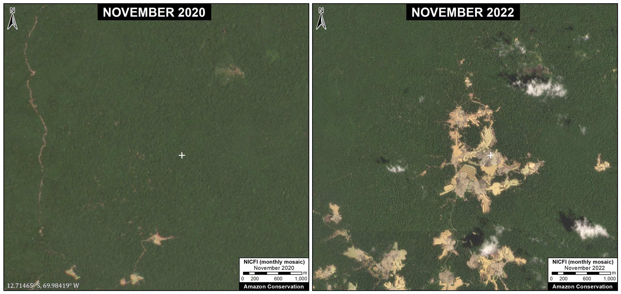
We estimate that the deforestation due to mining is 14,117 hectares within the Mining Corridor in the last two years (2021-2022). Below, we present a series of zooms of some emblematic examples of recent mining-related deforestation in the corridor (Images A-C).
Image A: Mining Corridor
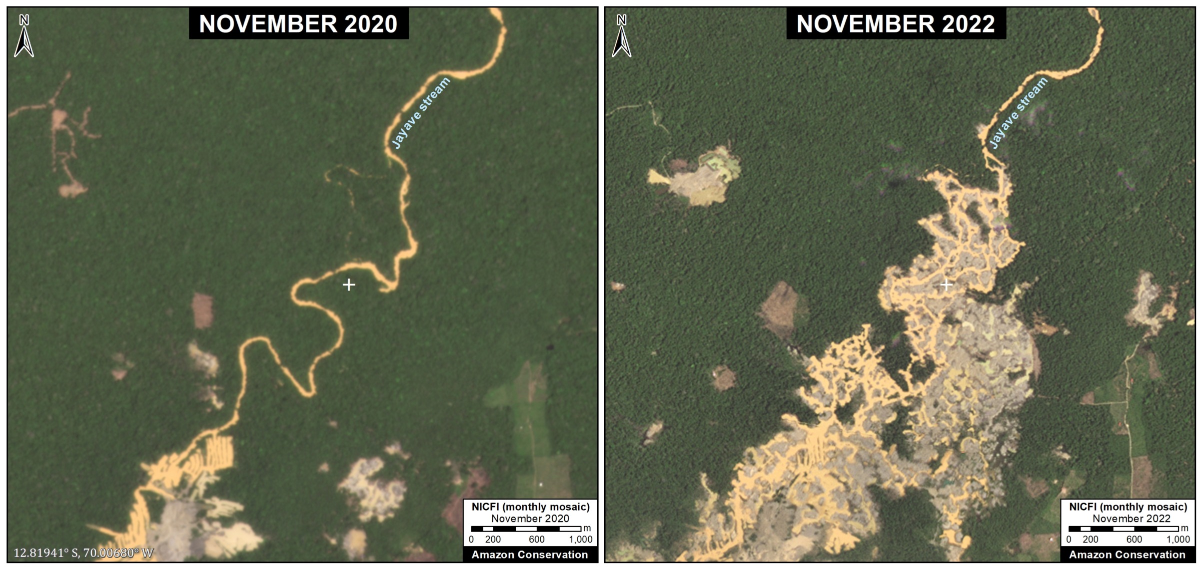
Image B: Mining Corridor
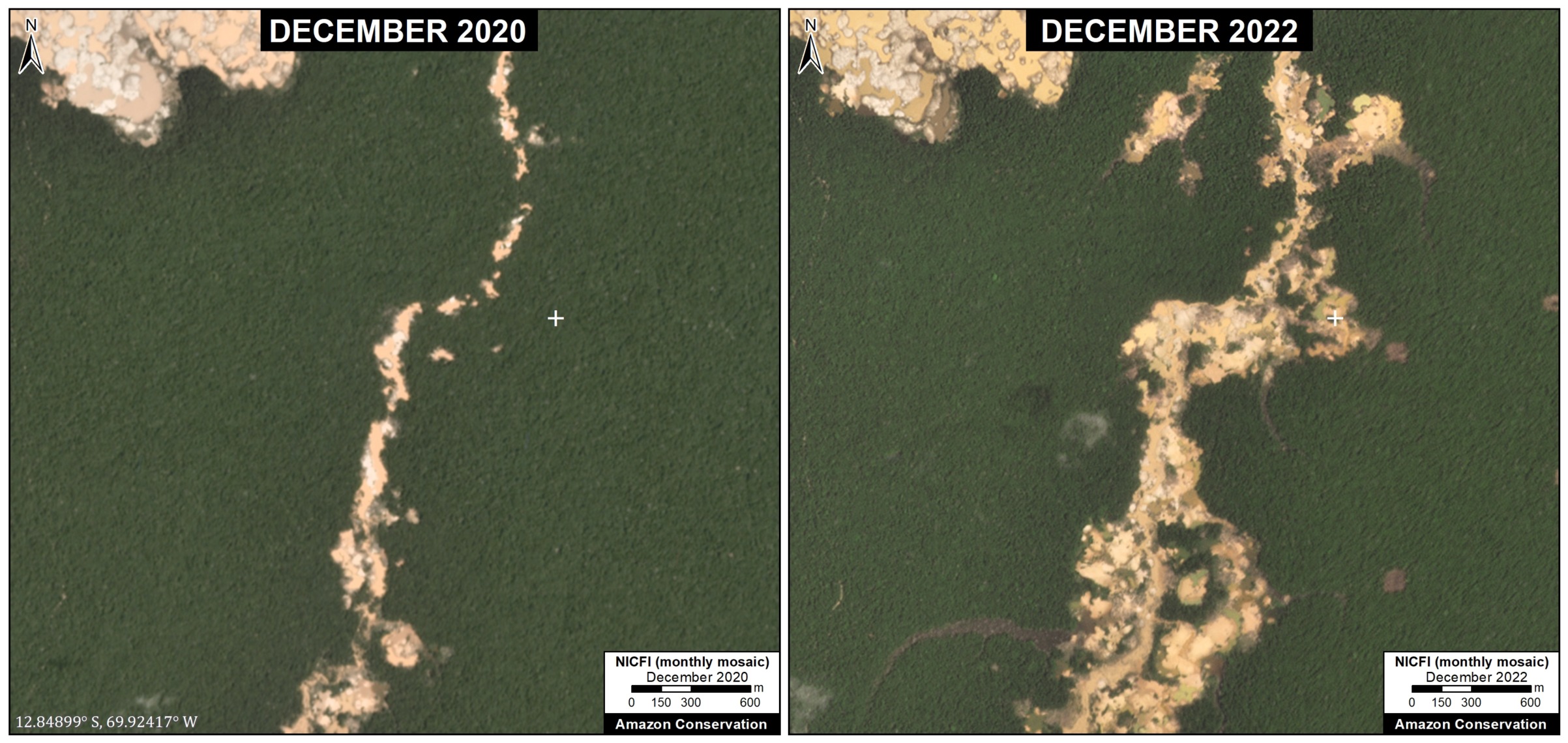
Image C: Mining Corridor
Outside of the Mining Corridor
The remaining deforestation due to mining (23.4%) is located outside the Mining Corridor. Breaking this down, 15% (2,769 hectares) occurred within indigenous territories, 4.8% (876 hectares) in buffer zones of protected areas, 0.8% (141 hectares) in forest concessions (for Brazil nuts), and 2.8% (517 hectares) in non-zoned areas during the last two years.
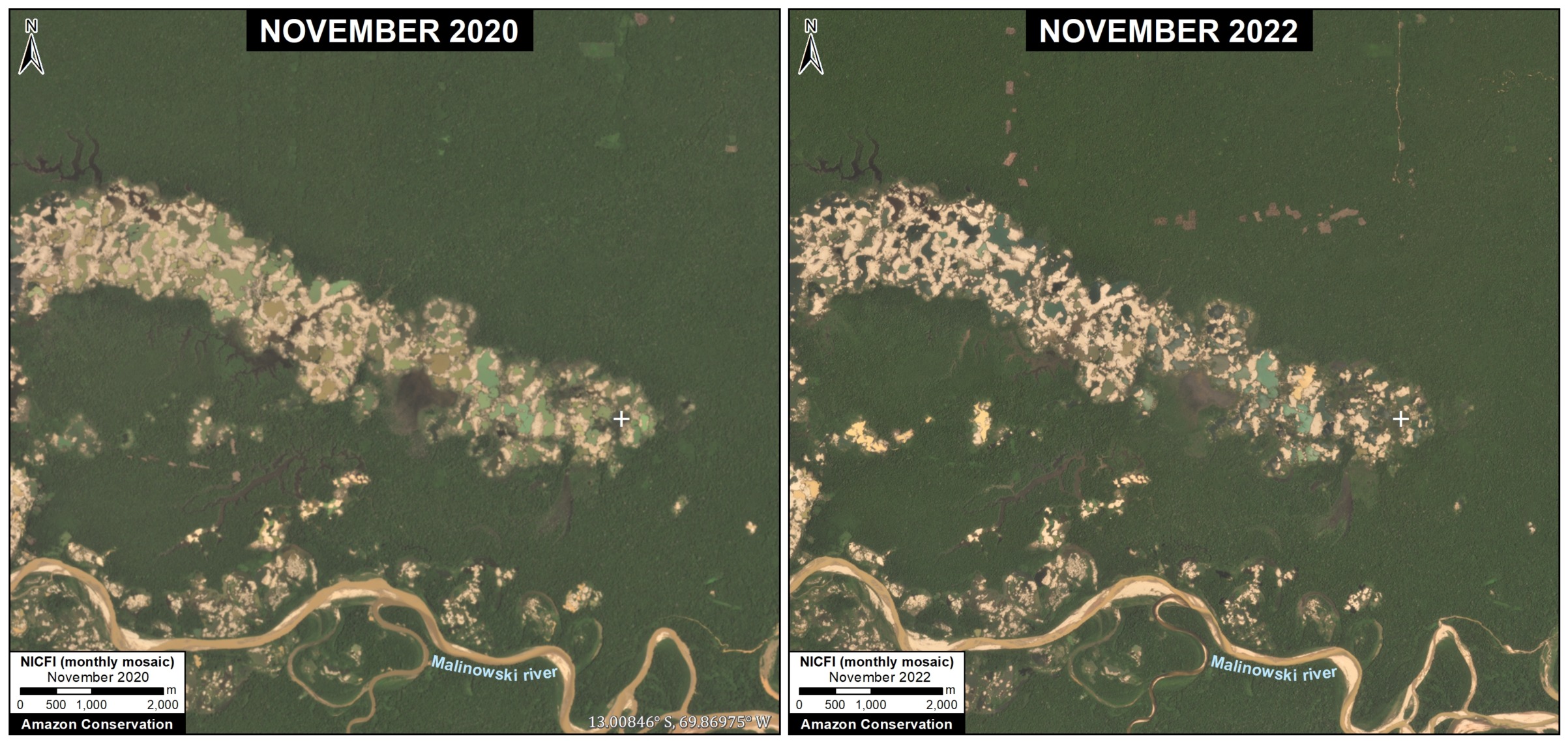
Regarding indigenous communities, the most affected were Barranco Chico (816 hectares) and San José de Karene (602 hectares), followed by Tres Islas (482 hectares), San Jacinto (177 hectares), Kotsimba (174 hectares), Puerto Luz (171 hectares), Boca Inambari (140 hectares), Shiringayoc (126 hectares), Arazaire (57 hectares), and El Pilar (23 hectares).
Regarding the buffer zones of protected areas, the most affected were the buffer zones of the Tambopata National Reserve, the Bahuaja Sonene National Park, and the Amarakaeri Communal Reserve. On the other hand, it has been found that mining within the actual protected areas, such as the Tambopata National Reserve and the Amarakaeri Communal Reserve, has been effectively controlled by the Peruvian government through the National Service of Natural Protected Areas (SERNANP).
Regarding forest concessions, deforestation due to mining was identified in 141 hectares within Brazil nut concessions in the Pariamanu and Pariamarca river basins.
Next, we continue with a series of zooms showing some emblematic examples of recent deforestation due to mining in the following prohibited areas: indigenous communities (Barranco Chico, Image D), buffer zone of the Bahuaja Sonene National Park (Chaspa, Image E), and Brazil nut concessions (Pariamanu, Image F).
We also present an important area in the buffer zone of the Tambopata National Reserve known as La Pampa (Image G). La Pampa was the epicenter of destructive deforestation due to gold mining between 2014 and 2018. We show that after Operation Mercury, which began in early 2019, the expansion of gold mining in La Pampa was essentially halted.
Image D: Barranco Chico (Indigenous Community)
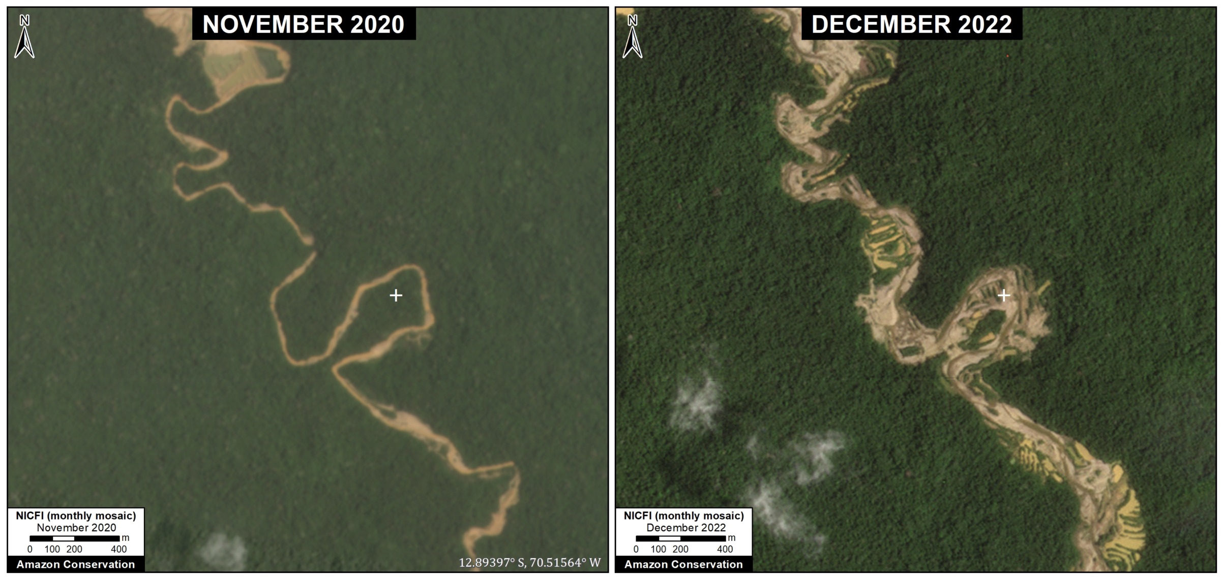
Image E: Chaspa (Buffer Zone of Bahuaja Sonene National Park)
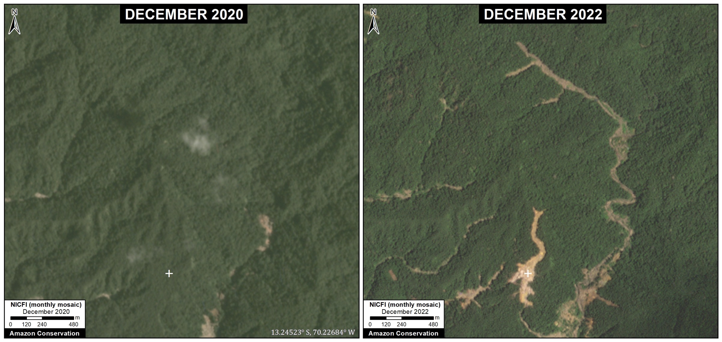
Image F: Pariamanu (Brazil Nut Concession)
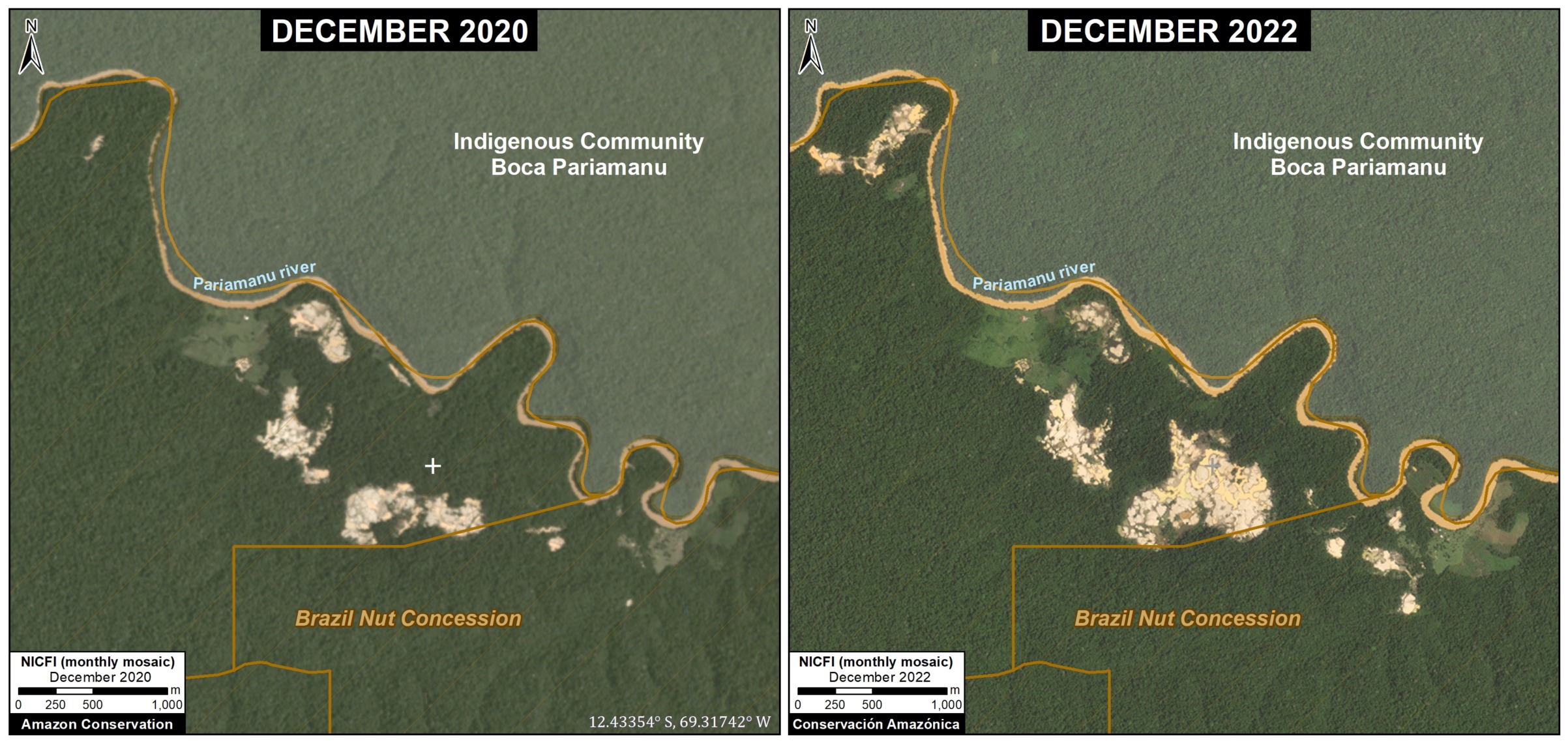
Image G: La Pampa (Buffer Zone of Tambopata National Reserve)
Annex
We show a version of the Basemap without the zoom insets.
Base Map (without insets). Deforestation by Gold Mining in the Southern Peruvian Amazon, with Update 2021-22. Click image to enlarge. Data: ACA/MAAP, CINCIA.
Notes
1The Mining Corridor, designated by Legislative Decree No. 1100 as the “Zone for small-scale and artisanal mining in the department of Madre de Dios,” categorizes mining activities as follows:
- Formal: Completed formalization process with approved environmental and operational permits.
- Informal: In the process of formalization; Operates only in authorized extraction areas, uses permitted machinery, and is considered an administrative offense, not a crime.
- Illegal: Operates in prohibited areas such as bodies of water (e.g., rivers or lakes), uses prohibited machinery, is considered a criminal offense, and is punishable by imprisonment.
2 Due to the possibility that these activities could be existing operations prior to the declaration of Natural Protected Areas and their buffer zones.
Methodology
Mining Corridor
We used LandTrendR, a temporal segmentation algorithm that identifies changes in pixel values over time, to detect forest loss within the Mining Corridor in 2021 and 2022 using the Google Earth Engine platform. It is important to note that this method was originally designed for Landsat images with moderate resolution (30 meters)1, but we adapted it for higher spatial resolution NICFI-Planet monthly mosaics (4.7 meters).2
Additionally, we created a baseline for the period 2016-2020 to eliminate old deforested areas (prior to 2021) due to rapid changes in the natural regrowth process.
Finally, we manually separated forest loss due to mining and other causes in 2021 and 2022 to specifically report on direct impacts related to mining. For this part of the analysis, we used various resources to aid the manual process, such as radar image alerts (RAMI) from the SERVIR Amazonia program, historical data from CINCIA from 1985 to 2020, forest loss data from the Peruvian government (National Forest Conservation Program for Climate Change Mitigation), and the University of Maryland.
- Kennedy, R.E., Yang, Z., Gorelick, N., Braaten, J., Cavalcante, L., Cohen, W.B., Healey, S. (2018). Implementation of the LandTrendr Algorithm on Google Earth Engine. Remote Sensing. 10, 691.
- Erik Lindquist, FAO, 2021
Outside the Mining Corridor
These places were identified as the main active fronts of deforestation due to gold mining, based on historical data from the Amazon Scientific Innovation Center – CINCIA and automatic alerts of forest loss generated by both the University of Maryland (GLAD alerts) and the Peruvian government platform (PNCBMCC-Geobosques).
The analysis combines the LandTrendr method (described earlier) with a photo interpretation based on high-resolution satellite images from Planet (3 meters). In each of the sites, we have detected, identified, and analyzed deforestation due to gold mining between 2021 and 2022. For areas with overlap between native communities and buffer zones, priority was given to the areas of the native communities.
Acknowledgements
We thank S. Novoa, C. Zavala, O. Liao, K. Nielsen, S. Otoya, and C. Ipenza for their valuable contributions and comments to this report, and R. McMullen for translation. We also thank C. Ascorra and M. Pillaca from the Amazon Scientific Innovation Center – CINCIA for providing us with historical mining data from 1985 to 2021.
This report was prepared with the technical support of USAID through the Prevent Project. Prevent (Proyecto Prevenir in Spanish) works with the Government of Peru, civil society, and the private sector to prevent and combat environmental crimes for the conservation of the Peruvian Amazon, particularly in the regions of Loreto, Madre de Dios, and Ucayali.
Disclaimer: This publication is made possible by the generous support of the American people through USAID. The contents are the sole responsibility of the authors and do not necessarily reflect the views of USAID or the United States Government.

Citation
Finer M, Mamani N (2023) Gold Mining Deforestation in the Southern Peruvian Amazon: 2021-2022 Update. MAAP: 185.
Download PDF of this article