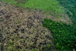
MAAP #136: Amazon Deforestation 2020 (Final)
*To download the report, click “Print” instead of “Download PDF” at the top of the page. In January, we presented the first look at 2020 Amazon deforestation based on early warning alert data (MAAP #132). Here, we update this analysis…
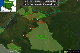
MAAP #133: Deforestation Continues in National Parks of Colombian Amazon
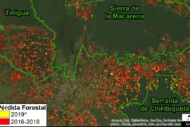
As we have indicated in previous reports (MAAP #120), there is an “arc of deforestation” in the northwest Colombian Amazon, impacting numerous protected areas and indigenous reserves. Here, we emphasize that this deforestation currently impacts four National Parks: Tinigua, Macarena,…
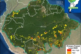
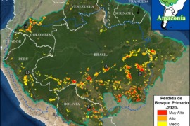
MAAP #132: Amazon Deforestation Hotspots 2020
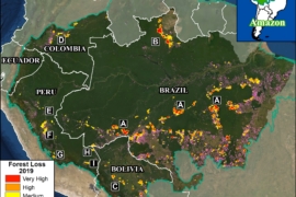
We present a first look at the major hotspots of primary forest loss across the Amazon in 2020 (see Base Map).* There are several major headlines: We estimate over 2 million hectares (5 million acres) of primary forest loss across…
MAAP #131: Power of Free High-resolution Satellite Imagery from Norway Agreement
This report demonstrates the powerful application of freely available, high-resolution satellite imagery recently made possible thanks to an agreement between the Government of Norway and several satellite companies.* This unprecedented agreement will bring commercial satellite technology, previously out of reach…
MAAP #122: Amazon Deforestation 2019
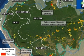
Newly released data for 2019 reveals the loss of over 1.7 million hectares (4.3 million acres) of primary Amazon forest in our 5 country study area (Bolivia, Brazil, Colombia, Ecuador, and Peru).* That is twice the size of Yellowstone National…
MAAP #120: Deforestation in the Colombian Amazon – 2020
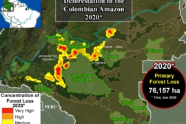
Here we present a first look at 2020 deforestation of primary forest in the Colombian Amazon, in relation to the new published annual data for 2019.* This new data confirms that deforestation decreased in 2019 (91,400 hectares) after a peak…
MAAP Synthesis: 2019 Amazon Deforestation Trends and Hotspots
MAAP, an initiative of Amazon Conservation, specializes in satellite-based, real-time deforestation monitoring of the Amazon. Our geographic focus covers five countries: Bolivia, Brazil, Colombia, Ecuador, and Peru (see Base Map). We found that, since 2001, this vast area lost 65.8…
Amazon Deforestation Trends, 2001-2019
These graphs correspond to MAAP Synthesis: 2019 Amazon Deforestation Trends and Hotspots.…
MAAP #106: Deforestation impacts 4 protected areas in the Colombian Amazon (2019)
We continue our focus on the northwest Colombian Amazon,* one of the most intense deforestation hotspots in the western Amazon (see MAAP# 100). Here, we analyze deforestation data over the past five years (2015-19) to better understand current trends and…
MAAP #101: Deforestation Continues in Colombian Amazon (2019)
A major deforestation surge continues in the northwest Colombian Amazon (MAAP #97). In 2018, it resulted in the loss of 199,000 hectares (491,700 acres)*, making it the most concentrated deforestation hotspot in the entire western Amazon (MAAP #100). Here, we…