MAAP #100: Western Amazon – Deforestation Hotspots 2018 (a regional perspective)
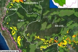
For the 100th MAAP report, we present our first large-scale western Amazon analysis: Colombia, Peru, Ecuador, Bolivia, and western Brazil (see Base Map). We use the new 2018 data for forest cover loss, generated by the University of Maryland (Hansen…
MAAP #97: Deforestation Surge in the Colombian Amazon, 2018 update
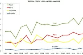
The Colombian Amazon is currently experiencing a deforestation surge (see graph). The surge started three years ago (2016) and peaked in 2017 with the highest annual deforestation on record (214,744 hectares).* Deforestation remains high in 2018: 156,722 hectares (based…
MAAP Synthesis #3: Deforestation in the Andean Amazon (Trends, Hotspots, Drivers)
MAAP, an initiative of the organization Amazon Conservation, uses cutting-edge satellite technology to monitor deforestation in near real-time in the megadiverse Andean Amazon (Peru, Colombia, Ecuador, and Bolivia). The monitoring is based on 5 satellite systems: Landsat (NASA/USGS), Sentinel (European…
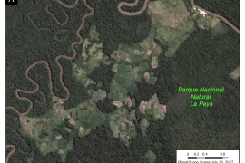
MAAP Colombia: Chiribiquete – Deforestation Hotspots in the Colombian Amazon, part 3
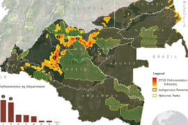
MAAP #86: Deforestation Hotspots in the Colombian Amazon, part 3: Chiribiquete-Macarena We present our third report* in a series investigating deforestation hotspots in the Colombian Amazon. Here, we focus on the “Chiribiquete-Macarena” hotspot, located between the Chiribiquete and La Macarena…
MAAP #77: Deforestation Hotspots in the Colombian Amazon, part 2
We present the second in a series of story maps investigating deforestation hotspots in the Colombian Amazon. Our goal is to identify the most critical hotspots (areas with the highest densities of deforestation) and use satellite imagery to identify the…
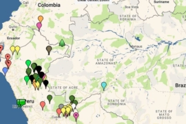
MAAP Interactive: Deforestation Drivers in the Andean Amazon
Since its launch in April 2015, MAAP has published over 70 reports related to deforestation (and natural forest loss) in the Andean Amazon. We have thus far focused on Peru, with several reports in Colombia and Brazil as well. These…
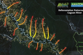
MAAP #63: Patterns of Deforestation in the Colombian Amazon
We are excited to present our initial analysis of the Colombian Amazon, a work that reflects an important collaboration with our colleagues at Amazon Conservation Team. It is also our first report in the more interactive “Story Map” format. This…
MAAP: Illegal Gold Mining in Puinawai National Park, Colombia
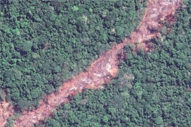
We documented the recent illegal gold mining deforestation Puinawai National Park, Colombia. …