MAAP #108: Understanding the Amazon Fires with Satellites, part 2
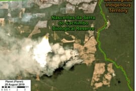
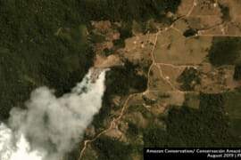
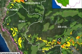
Here we present an updated analysis on the Amazon fires, as part of our ongoing coverage and building off what we reported in MAAP #107. First, we show an updated Base Map of the “fire hotspots” across the Amazon, based…
MAAP #107: Seeing the Amazon Fires with Satellites
Fires now burning in the Amazon, particularly Brazil and Bolivia, have become headline news and a viral topic on social media. Yet little information exists on the impact on the Amazon rainforest itself, as many of the detected fires originate…
MAAP #100: Western Amazon – Deforestation Hotspots 2018 (a regional perspective)
For the 100th MAAP report, we present our first large-scale western Amazon analysis: Colombia, Peru, Ecuador, Bolivia, and western Brazil (see Base Map). We use the new 2018 data for forest cover loss, generated by the University of Maryland (Hansen…
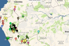
MAAP Interactive: Deforestation Drivers in the Andean Amazon
Since its launch in April 2015, MAAP has published over 70 reports related to deforestation (and natural forest loss) in the Andean Amazon. We have thus far focused on Peru, with several reports in Colombia and Brazil as well. These…
Bolivia: Large-scale Sugarcane Deforestation
New sugarcane plantations have caused the deforestation of more than 6,175 acres (2,500 hectares) in the department of La Paz. https://news.mongabay.com/2016/10/exclusive-rainforest-rapidly-cleared-for-sugarcane-in-bolivia/ https://news.mongabay.com/2016/11/another-700-hectares-of-bolivian-rainforest-lost-to-sugarcane-surge/…