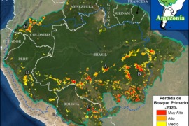
MAAP #136: Amazon Deforestation 2020 (Final)
*To download the report, click “Print” instead of “Download PDF” at the top of the page. In January, we presented the first look at 2020 Amazon deforestation based on early warning alert data (MAAP #132). Here, we update this analysis…
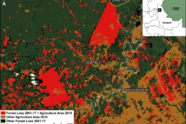
MAAP #134: Agriculture and Deforestation in the Peruvian Amazon
For the first time, Peru has a detailed National Agricultural Area Map. This unique map, produced with high-resolution satellite imagery, was published by the Peruvian Ministry of Agrarian Development (MIDAGRI) in January.* This map reveals that the agricultural area at…
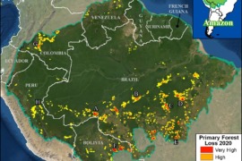
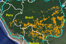
MAAP #132: Amazon Deforestation Hotspots 2020
We present a first look at the major hotspots of primary forest loss across the Amazon in 2020 (see Base Map).* There are several major headlines: We estimate over 2 million hectares (5 million acres) of primary forest loss across…
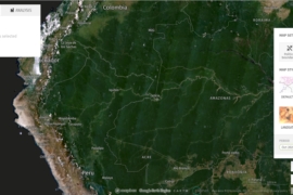
MAAP #131: Power of Free High-resolution Satellite Imagery from Norway Agreement
This report demonstrates the powerful application of freely available, high-resolution satellite imagery recently made possible thanks to an agreement between the Government of Norway and several satellite companies.* This unprecedented agreement will bring commercial satellite technology, previously out of reach…
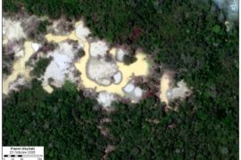
MAAP #130: Illegal Gold Mining Down 78% in Peruvian Amazon, But Still Threatens Key Areas
As part of USAID’s Prevent Project (dedicated to combating environmental crimes in the Amazon), we conducted an updated analysis of illegal gold mining deforestation in the southern Peruvian Amazon. In early 2019, the Peruvian government launched Operation Mercury, an unprecedented…
MAAP #129: Amazon Fires 2020 – Recap of Another Intense Fire Year
Following the intense Amazon fire season of 2019 that made international headlines, here we report another major fire year in 2020. Using the novel data from our real-time Amazon Fires Monitoring app,* we documented over 2,500 major fires across the…
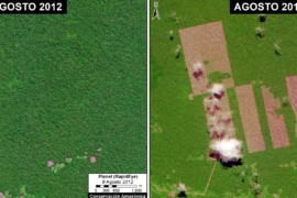
MAAP #128: United Cacao Case – 7 Years After Massive Deforestation in the Peruvian Amazon
Here, we confirm the massive deforestation of primary forest (more than 2,000 hectares) in the Peruvian Amazon by the company United Cacao between 2013 and 2016. We present a series of recently obtained (and never before published) satellite images to…
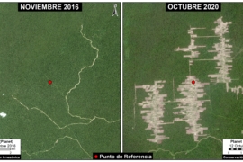
MAAP #127: Mennonite Colonies Continue Major Deforestation in Peruvian Amazon
The Mennonites, a religious group often associated with organized agricultural activity, have started three new colonies in the Peruvian Amazon. We have documented the deforestation of 8,500 acres (3,440 hectares) in these three colonies over the past four years (updated…
MAAP #126: Drones and Legal Action in the Peruvian Amazon
The southern Peruvian Amazon (Madre de Dios region), is threatened by illegal mining, logging, and illegal deforestation. In response, an association of forest concessionaires (known as ACOMAT) is implementing a comprehensive monitoring system that links the use of technology (satellites…
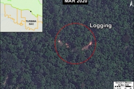
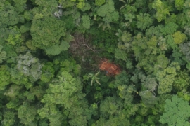
MAAP #125: Detecting Illegal Logging with Very High Resolution Satellites
Illegal logging in the Peruvian Amazon is mainly selective and, until now, difficult to detect through satellite information. In this report, we present the enormous potential of very high resolution satellite imagery (<70 cm) to identify illegal logging. The leading…